Quick Hitting System To Bring A Burst Of Snow In Parts Of The Northeast And Mid Atlantic This Evening Into Tonight
Hello everyone!
After several days of quiet weather, a fast-moving system will brifely return parts of the East to winter-like conditions this evening into tonight as snow falls heavily at times for some areas. While our strongly zonal pattern discussed a couple days ago will ensure this system doesn’t stick around for more than 6-8 hours at any given place, some spots in Southern New England could see a half foot of snow fall in that time. I’ll go over some of the factors driving this system, as well as what to expect in the way of accumulations and impacts.
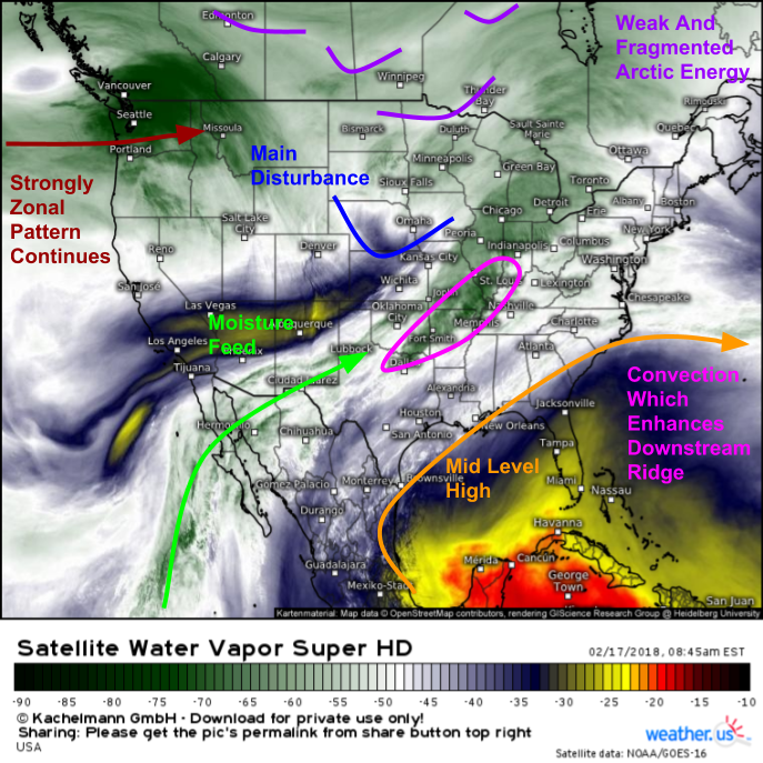
Water Vapor satellite imagery from GOES-East (what’s that?) is always a good place to start when evaluating a near-term storm threat. This morning, we can see all the elements that will come together to produce snow in the Northeast, as well as the elements that will prevent this from being a major storm. The main disturbance behind this system is currently located over Nebraska and is moving quickly ESE. Out ahead of this, an area of convection is noted from Dallas up towards Indianapolis. This convection will continue to move east, and while no severe weather is expected, the heat energy released into the upper atmosphere from these showers and storms will enhance upper level high pressure (ridging) downstream of the system. This process is one of a couple that will create a small window of opportunity in the midst of a pattern generally unfavorable for noteworthy snow. While this opportunity will exist, there are several factors visible on satellite imagery that are working against this storm. A large mid level high over the Gulf of Mexico means that this storm’s moisture has to come all the way from the Eastern Pacific. While this will be sufficient for precipitation, if you really wanted a significant snowstorm, you’d need at least some help from the Gulf of Mexico and Western Atlantic. There’s also a significant storm system entering the Pacific Northwest this morning which, in addition to bringing rain and mountain snow to that part of the country, will continue our zonal (west-east) wind pattern that will usher this storm quickly along to the east.
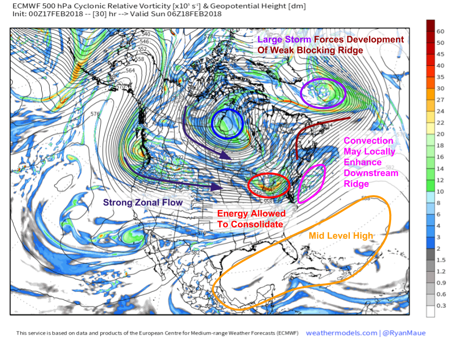
This ECMWF 500mb vorticity (energy) map shows what each of the features discussed above is expected to look like tonight. We can clearly see the mid level high shutting off moisture supplies from the Gulf of Mexico and the Western Atlantic, as well as that storm in the Pacific Northwest continuing to promote strong zonal flow across the country. However, there is one more piece to the puzzle that explains why despite the unfavorable upstream pattern, this storm will produce noteworthy snow. Notice the strong storm located off the southern tip of Greenland. This storm is helping to drive the development of some ridging over the Canadian Maritimes. Ridging acts like the brick wall of the atmosphere, and energy that encounters ridging is rarely strong enough to simply defy it. As a result, the energy currently moving across the Central US will be allowed to consolidate a little bit as it runs into the ridge, which won’t be strong enough to support major storm development, but will be just strong enough to turn flurries into a few inches.
Map from weathermodels.com.
Here’s the NAM’s portrayal of the stom over the next 24 hours. Snow will break out over parts of Western PA, Northern WV, and western MD/VA this afternoon, before spreading east towards coastal parts of the Mid Atlantic this evening. DC will be right on the rain/snow line, and is likely to see an initial burst of snow that quickly changes to rain as warm air moves north. A more prolonged burst of moderate to heavy snow is expected farther north in places like Philadelphia and Northern New Jersay. Snow will then move enortheast into New England tonight, with the heaviest snow in southern parts of the region and lighter amounts in the mountains of Vermont, New Hampshire, and Maine.
Map from weathermodels.com.
Here’s a look at how much snow to expect from this system. Most areas will fall in the 2-4″ range, with lighter amounts on the NW fringes of the system, as well as where snow mixes with or changes over to rain right along the coast. Heavier amounts of 4-8″ are expected just north of the rain/snow line from Northern NJ through CT and into parts of RI and SE MA. Keep in mind that even though we’re only 12 hours away from the event, there’s still some uncertainty as to exactly where the rain/snow line sets up. Forecasting the location of this line within 10-20 miles is a scientific accomplishment, but for those folks within that 10-20 mile zone, this remains a situation where impacts are hard to pin down.
Map from weathermodels.com.
Follow along with this storm using the tools we have at weather.us including HD radar (click to zoom in for the HD data at state level, then click again for counties) https://weather.us/radar-us, GOES-East satellite imagery (click to zoom in, or use menus to navigate to custom zoom mode) https://weather.us/satellite/satellite-infrared-superhd-5min.html, and current observations https://weather.us/observations/weather-observation.html (click to zoom in, other parameters via menus). Still curious about exactly what to expect in your town? Check out our Forecast Essentials tool https://weather.us/forecast/essentials for a basic overview, or our Forecast Ensemble tool https://weather.us/forecast/ensemble for more information about the range of potential outcomes and forecast uncertainty.
-Jack


