Powerful Ocean Storm To Bring Heavy Snow And High Winds To The East Coast Beginning Tomorrow
Hello everyone!
A powerful ocean storm is about to put on a dazzling display of raw atmospheric power off the East Coast beginning tomorrow. This system will be much stronger than your typical nor’easter, and will look (and, for parts of eastern New England, feel) like a hurricane by Thursday morning. One of the many unusual aspects of this storm will be the wide-ranging scope of wintry weather. Significant snow and ice will fall from the beaches of Florida’s Gulf Coast to the rocky outcroppings of Northeastern Maine. Additionally, winds will be gusty out of the Northwest for the entire eastern half of the country as the system intensifies. For parts of Eastern New England, winds will approach hurricane force as the core of the storm moves by offshore on Thursday. Behind the storm, a blast of bitter cold air will bring subzero wind chills as far south as Georgia as we head into the weekend.
In addition to this update which focuses on impacts, be sure to check out Dr. Ryan Maue’s blog that uses some of the cool new tools we have at weathermodels.com to highlight some of the storm’s unusual features.
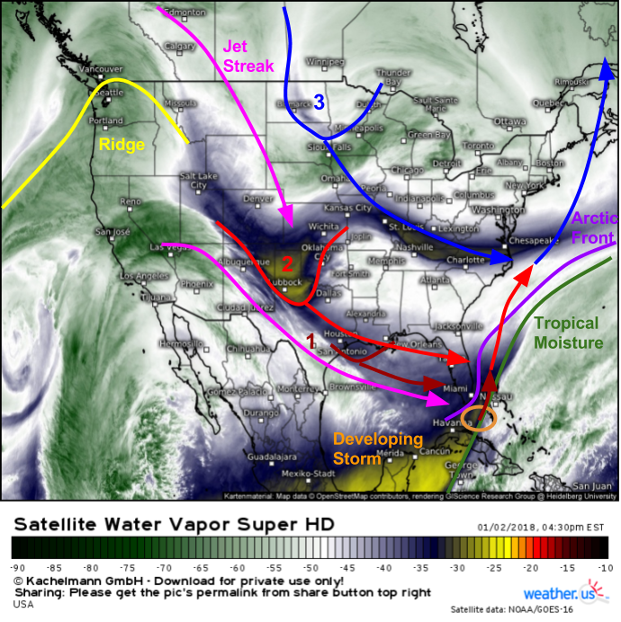
Here’s a look at Water Vapor satellite imagery (what’s that?) from this afternoon showing all the ingredients for our storm coming together. A strong Arctic front stretches from the waters between Bermuda and North Carolina down to the Florida Straits. A wave of low pressure is already developing along this front, and this is the system that will soon intensify into our powerful storm. Three disturbances are lined up in the center of the country, and each will drive a phase of our storm’s evolution. The first disturbance, noted as a weak wave in the Gulf of Mexico, will put an end to the Arctic front’s push southward, and begin the process of drawing the low, and its tropical moisture, towards the north. The second disturbance is much stronger, and is diving ESE across parts of TX and OK this evening. It will result in explosive intensification of the storm tomorrow afternoon/evening. The third disturbance is located across the northern plains and will result in the storm curving to the NNE as it departs the Outer Banks area on Thursday.
As the forecast has become significantly clearer in the past 24 hours, this post will focus mostly on the storm’s impacts, as well as some of the meteorology behind them instead of an analysis of what’s behind the system as a whole. For that discussion, check out last night’s post.
Part 1: Florida/Georgia Wintry Mix: 5AM – 2 PM Wednesday
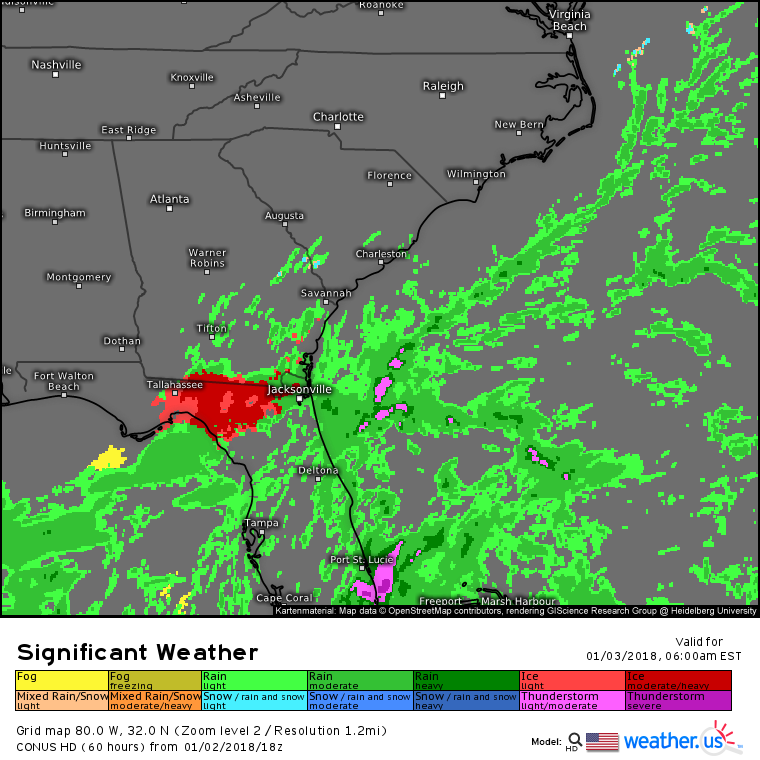
The first wintry precipitation will fall across parts of Northern Florida from the Gulf Coast south of Tallahassee to the capital itself and east to Jacksonville. SE Georgia will also get in on the action with light freezing rain and sleet beginning tomorrow morning roughly SE of an Albany – Macon – Augusta line. The main impact from this phase of the storm will be extremely slippery travel conditions due to ice building up on roadways.
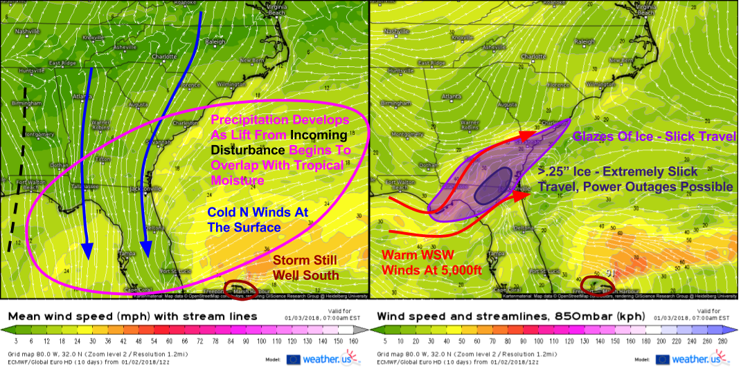
What’s behind the freezing rain? Here’s a little of the meteorology behind the madness. At the surface (left panel), winds are out of the north and subfreezing air is established due to the fresh tap of our Arctic airmass. Aloft (right panel), winds are out of the WSW and are transporting above freezing air into the region. As lifting gets going ahead of the incoming disturbance, precipitation will break out and as it falls, it will melt in the warm layer aloft, before freezing onto cold surfaces such as roads, trees, and power lines which will all be below 32 degrees due to the north winds. I’ve highlighted the areas expected to see ice impacts from the first phase of the storm which will get underway even before the system really intensifies.
Part 2: Carolina Snow: 2 PM Wednesday – 4 AM Thursday
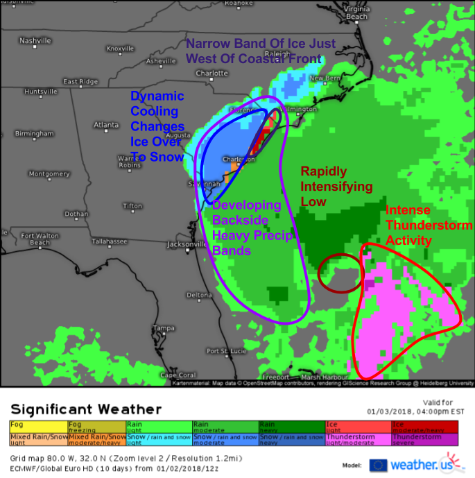
Tomorrow afternoon, our main area of low pressure will begin to rapidly develop off the Florida coast. This development will usher in a whole new set of dynamics that will result in the beginning of the next phase of the system’s impacts: heavy snowfall in the Carolinas. As this process unfolds, bands of heavy precipitation will begin developing on the NW side of the storm. These heavy precipitation bands will move onshore in coastal parts of Georgia and South Carolina tomorrow afternoon. If precipitation is heavy enough, it can mix out the warm layer aloft, a process which will be aided by the development of mid level low pressure centers offshore. As a result, expect ice to change to snow across far eastern parts of Georgia and the southeastern half of South Carolina. Snow will then be heavy at times for a few hours before the system moves NE and North Carolina becomes the main focus.
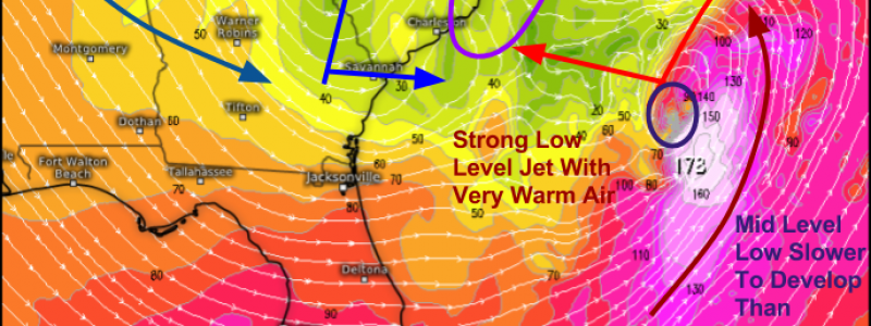
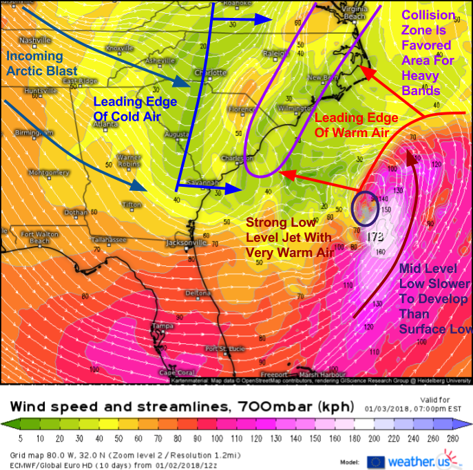
Here’s a glimpse at the dynamic process most important to the heavy precip in coastal parts of the Carolinas tomorrow evening. It’s a process known as frontogenesis, which literally means “creation of a front”. We know that a front is a boundary between two different airmasses, so we can create a front by taking two different airmasses and pushing them close together. A look at the 700mb (10,000ft) wind forecast from the ECMWF model for tomorrow evening, we can see that’s exactly what’s happening. As the mid level low forms and deepens (the formation of a closed off circulation during cyclogenesis happens from the bottom up), developing ESE flow ahead of it leads to a northwestward extension of the low level jet we see to the southeast of the system. This LLJ feature is carrying with it tremendous amounts of warm moist air. Meanwhile over Georgia, the leading edge of our next Arctic blast is rushing south, on a collision course with the expanding warmth. Where these two airmasses collide is where frontogenesis occurs, and where frontogenesis occurs, heavy bands of precipitation set up.
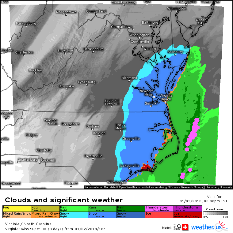
This Swiss Super HD model forecast shows the result of the frontogenesis dynamics discussed above. Moderate to heavy bands of snow will impact SE Virginia, Eastern North Carolina, and Southern parts of Maryland late tomorrow evening into tomorrow night. As the heavy precipitation cools the mid levels of the atmosphere, precipitation type will become dominated by near surface temperatures. Rain is likely along the Outer Banks where NNE winds blow in off the (relatively) warm waters of the Atlantic. You won’t have to go far inland though to get into the snow. Eventually, as the storm begins to depart to the northeast and additional energy from the Arctic arrives, even the Outer Banks will see a period of snow early on Thursday morning.
Part 3: New England Blizzard: 5 AM Thursday – 12 AM Friday
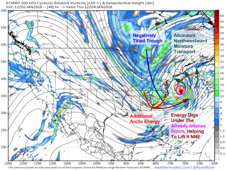
Here’s a look at what’s forecast to happen at 500mb (~20,000ft) on Thursday morning. We’ll already have an intense storm due to the efforts of our first three disturbances. The last disturbance will dig under the storm, helping it to lift NNE instead of get kicked ENE. The negative tilt (if you drew an x-y coordinate plane over the map, the line representing the trough axis would have a negative slope) of the trough is important because it helps to let moisture surge northwestward into the bitter cold airmass we have locked in place. This collision of airmasses will continue to fuel heavy precipitation, even after the fronts created over the Carolinas will already be well established.
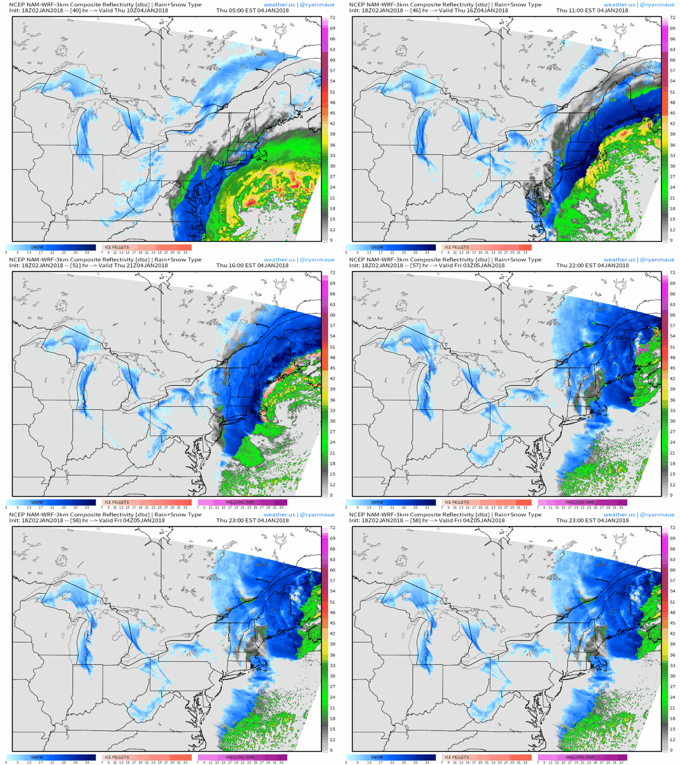
Here’s the NAM model’s interpretation of what will happen as the already-intense storm roars by off the New England coastline. Snow will move in from south to north on Thursday morning, with flakes falling in Boston by 6 AM and Portland Maine by 8. Snow will quickly ramp up as moderate-heavy bands roll in off the ocean. Depending on exactly how close the storm passes to the coastline, parts of Eastern New England from Boston to Portland to Bangor may get into some of the “inner core” bands that will feature intense 3-4″/hour snowfall rates, and wind gusts of 50-65 mph. Regardless, even the bands outside of the core will pack 1-3″/hour snowfall rates and wind gusts of 30-50 mph, more than enough to overwhelm plows and reduce visibilities to near zero. There’s a good chance that coastal parts of the region I just highlighted will meet official blizzard criteria. A blizzard is defined as a period of time greater than or equal to 3 consecutive hours when visibilities are reduced to 1/4 mi or less due to falling or blowing snow with winds either sustained or frequently gusting at or above 35 mph hour.
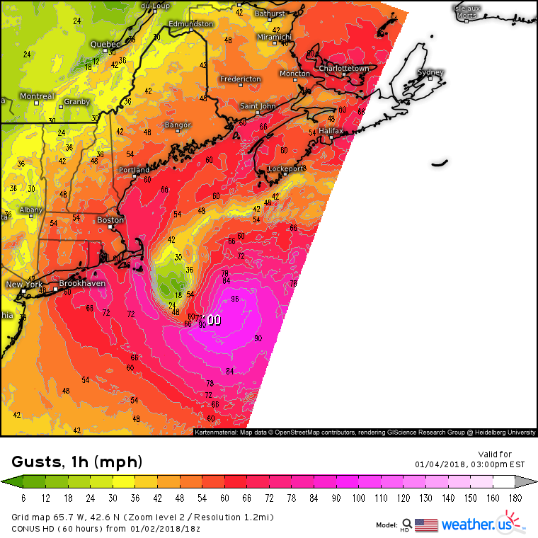
Here’s the NAM’s wind gust forecast, which I think does a pretty good job highlighting who’s expecting the worst of the winds. For Cape Cod and the islands, gusts to hurricane force are expected. Winds along the rest of the MA, NH, and ME coastline will likely push 65 mph, with lesser values inland. I think the model may be overly bullish on 50+ mph winds extending all the way into parts of Western New England, though that is a possibility if the track farther west that the NAM is depicting comes to fruition. Even with wind gusts of 40-50 mph, power outages are possible, so be prepared to be without electricity during a time of bitter cold if you live anywhere in New England, but especially along the coast.
Part 4: Post Storm Arctic Blast: Friday – Monday
Behind the storm, cold air will pour southward resulting in dangerous wind chills all the way to Georgia. This part of the post is copied and pasted from last night’s discussion, as everything still applies with regards to the post storm cold shot.
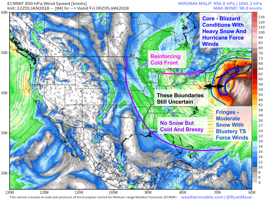
This map from the ECMWF shows the storm’s massive wind field, stretching from the Mississippi River out into the Central Atlantic. Even if you’re over a thousand miles from the storm’s center, you’ll be feeling its effects in the form of a very cold NW wind. That wind will be tapping air straight from the Arctic, and you’ll notice it!
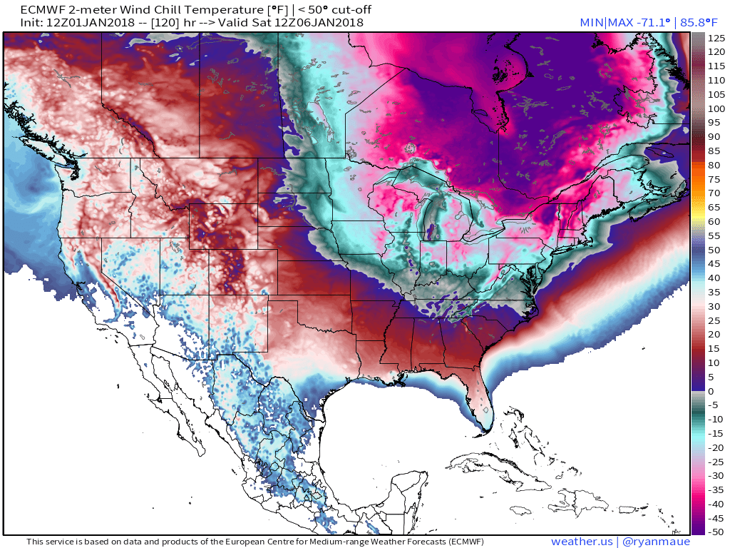
Behind the storm, bitter cold air will pour south. This map shows wind chills Saturday morning, when subzero values will extend as far south as Georgia. In the Northeast, values will drop below -20 for much of New England, including the coastline. Take proper precautions if you plan to be outside in the frigid weather!
Overview
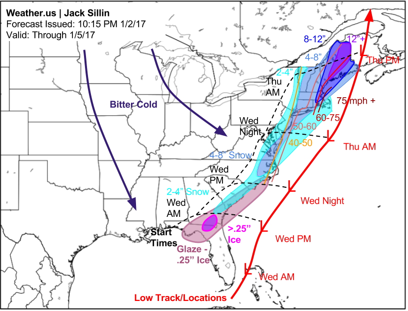
Here’s my overall thinking for snow, ice, and wind impacts from this storm as well as where I think the system will track and when precipitation will start. I haven’t hit on every single impact, the combination of astronomically high tides and strong winds will result in coastal flooding concerns for parts of New England, especially where sea ice has formed due to the unusual cold. Moving ice can cause damage to docks and other structures on/near the water if high winds and stormy seas set it in motion.
Several of the maps used in this post come from weathermodels.com, our new subscription service at weather.us. Be sure to sign up for a free trial anytime before January 25th to give it a try! Also be sure to check out Dr. Ryan Maue’s blog post highlighting some of the technical elements of the storm I didn’t mention here, as well as how to use some of the tools on weathermodels.com to forecast this storm.
I’ll be following this system as it evolves tomorrow on Twitter. Follow us at @WeatherdotUS and you can also follow me at @JackSillin
-Jack


Thanks for yet another english version explanation of what takes place during such mega-Nor’easters. Would you please explain how such beasts are fueled on a sustained basis? They seem similar, but I’ver read over and over: not the same, as hurricanes. My suspicion is they peter out quickly once they go too far north, probably by cold air strangulation arriving south of storm central.
Nor’easters are fueled by the energy stored up in what’s called a baroclinic zone, which is basically a sharp temperature gradient. As long as there’s a gradient (between cold air over the North American continent and warm air over the Gulf Stream), there will be fuel for these storms. You’re correct that they peter out as they head north, that’s because the gradient lessens once you move into the part of the world that is just plain cold this time of year (no warmth to generate contrast)