Phase Two of This Weekend’s Storm System To Bring Heavy Snow and Severe Storms To Parts Of The Great Lakes and Mississippi Valley Sunday-Monday
Hello everyone!
This post will take a more detailed look at phase two of the large and complex storm system expected to impact the eastern two thirds of the country as 2019 comes to a close in the next few days. An overview of the system can be found in this post while more detailed information on phase one can be found here. A link to more detailed info on phase three will be posted below. The second phase of the storm will begin developing in the central Mississippi Valley on Sunday afternoon as the first phase begins weakening over the Northern Plains.
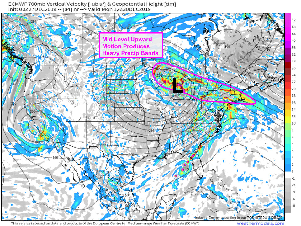
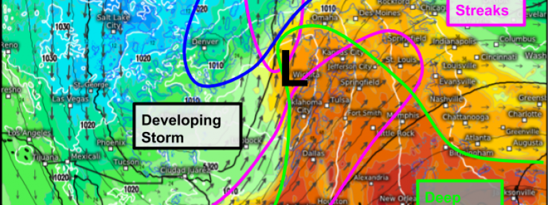
The ECMWF’s Synoptic Composite map does a good job highlighting the features that will be important to phase two’s development on Sunday afternoon/evening. A strong upper level disturbance will be moving through the Southern/Central Plains after diving through the Rockies today and turning east towards Texas tomorrow. Strong forcing for ascent (upward motion) ahead of this disturbance, combined with upper level divergence associated with a strong jet streak (note the long black arrows signifying strong winds at 300mb), will result in the formation of a secondary area of low pressure (“phase two”) near Memphis. This storm will rapidly intensify as it moves north-northeast on Sunday night before reaching its peak intensity over the Great Lakes on Monday morning. A quick look at the system’s position relative to the theta-e gradients associated with the first storm’s frontal structures shows that this secondary area of low pressure will be developing firmly within the warm sector of the first storm. As a result, it’s not expected to produce much in the way of wintry precipitation during the first part of its lifecycle on Sunday. That being said, it will produce some severe weather across parts of Mississippi and Alabama on Sunday evening.
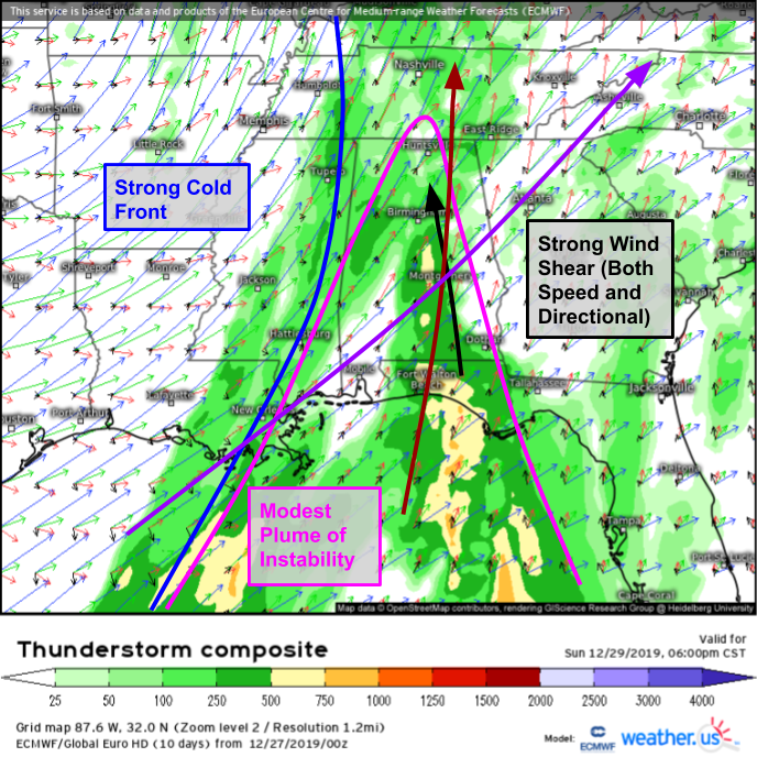
The best way to take a look at the ingredients for a severe weather setup is the ECMWF’s Thunderstorm Composite forecast map shown here. The lack of bright red/orange colors means that there won’t be a ton of CAPE (instability). This makes sense as it’s hard to get hot and humid air in late December, even over Alabama. However, the storm’s strong cold front will provide plenty of upward motion to get storms going, and the strong mid/upper level winds (highlighted in dark red and purple respectively) will provide plenty of wind shear (both speed and directional) for storm organization. Given the strong cold front and the orientation of the mid level winds roughly parallel to the front, this looks to be a primarily linear storm-mode event, though one or two supercells can’t be ruled out. Thus the primary threat will be damaging winds, with the chance of a couple tornadoes.
As the storm approaches its peak intensity early on Monday morning, a round of intense frontogenesis banding will develop over the Great Lakes. When combined with the deep tropical moisture moving north out of the Gulf of Mexico, this frontogenesis will produce bands of heavy precipitation. Remember that phase two of the storm is developing in the warm sector of the first storm, which means that initially there won’t be enough cold air for snow. However, the strong upward motion in these heavy precip bands combined with the latent heat processes associated with melting and the advection of colder air into the Great Lakes on the northwest side of the surface low will result in falling temps and a changeover to snow during the morning hours on Monday.
This loop of temperatures at 850mb (~5000ft) shows the rapid dynamic cooling over Wisconsin and the UP of Michigan as the second phase of the storm kicks into gear on Monday. As this dynamic cooling takes place, expect a changeover from rain to snow to occur from NW to SE during the day on Monday. Road conditions will quickly deteriorate as this process takes place, so be sure to plan ahead if you need to travel.
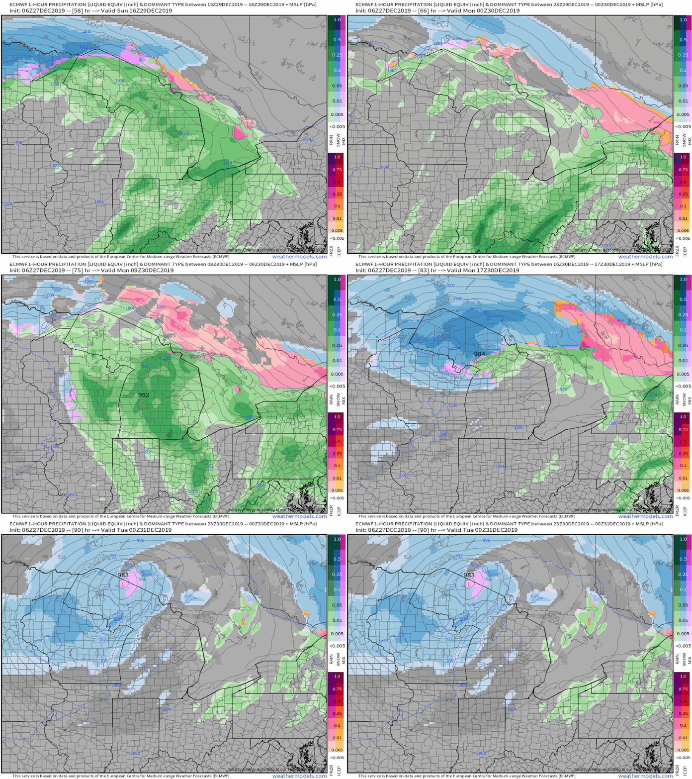
Hourly forecasts of precipitation type from the ECMWF do a good job showing how this process of dynamic cooling will translate into changing conditions at the surface. Once the changeover from rain to snow occurs, snow will fall at rates of 1-3″ per hours during the day on Monday as lifting of a similar intensity to that observed over the Northern Plains on Sunday develops.
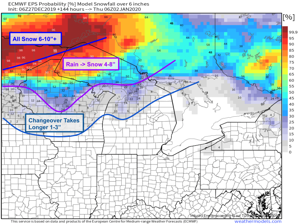
Here’s a look at approximate snowfall totals based on today’s forecast info. The most snow will fall in NE Minnesota where mixing is unlikely to occur at any point during either the first or second phases of the storm’s evolution. Rain will change to snow the fastest over northern Wisconsin and the UP of Michigan where a general 4-8″ of snow is expected. Farther south, snow will fall but the changeover will take longer so accumulations are likely to be much lower. Keep in mind that these numbers are only a ballpark estimate and will be refined further in the coming days. Because the warmest air in this part of the storm will be found at the surface (instead of aloft), limited icing concerns are expected in the Great Lakes as a result of phase two.
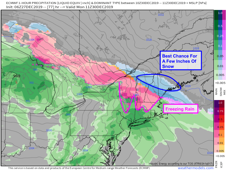
The same cannot be said for the Northeast where phase two will behave similarly to how phase one behaved in the Great Lakes. Warm air aloft will attempt to move northeast into the cold airmass previously established by the disturbances currently moving through Canada. The result will be a fairly widespread area of freezing rain across the Adirondacks, Catskills, and the mountains of northern New England. I will discuss the impacts expected from this system in New England in more detail later tonight in my phase-three blog.
-Jack

