Phase Three Of This Weekend’s Storm System To Bring Snow and Ice To New England For New Year’s
Hello everyone!
This post will take a more detailed look at phase three of the large storm system expected to develop across the country over the next several days. If you’re looking for a general overview of the system or more detailed information on the first and second phases of the system’s evolution, please refer to the linked posts.
Meteorologically speaking, the first wave of impactful weather in the Northeast will come as a result of the warm front associated with the second phase of the storm. With that in mind, because I focused on the Great Lakes/Southeast aspect of the system in my phase two post, I will begin my discussion here with the first wave of precipitation expected to begin on Sunday night for the sake of geographical consistency.
On Sunday night (the above forecast map is valid at 10 PM EST), phase two of the storm will be developing over the southern Great Lakes and a warm airmass will be moving up the Appalachians on the storm’s eastern side. That warm airmass will be running into a very cold and dry airmass moving south from a strong area of high pressure in central Quebec. This clash of airmasses will power the first round of precipitation over the Northeast beginning late Sunday evening and continuing through much of the day on Monday. Because warm air is less dense than cold air, it will be quite difficult for the approaching warm airmass to dislodge the cold airmass already in place across interior parts of the Northeast. This process will be most difficult at and near the surface, where topographic features help provide additional fortification for the cold. Aloft, the warm air will have an easier time moving in from the south/southwest. This will set up an environment conducive for freezing rain and sleet, with a layer of warm air aloft to melt the falling snow and a thin layer of cold air near the surface to help the rain refreeze either on contact with the ground (freezing rain) or into small ice pellets (sleet).
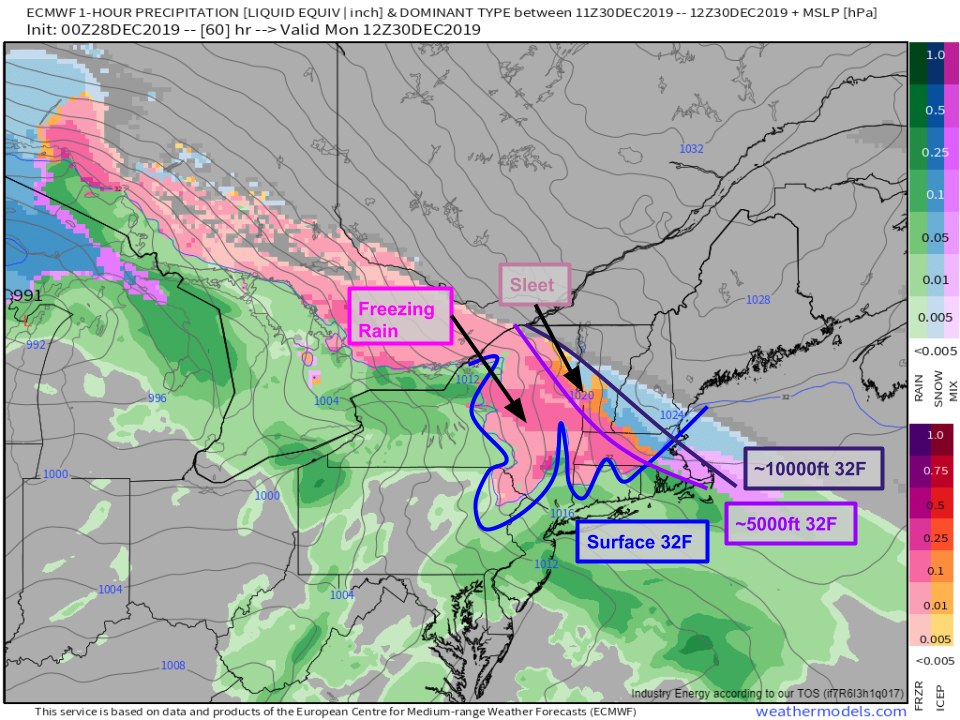
A closer look at the forecast for Monday morning shows widespread freezing rain and sleet as the freezing line at the surface lags well to the southwest of the freezing line at both 5,000 feet (generally the cutoff between sleet and freezing rain) and 10,000 feet (a good proxy for the sleet/snow line). As a result, expect extremely icy conditions across much of eastern NY, northern CT, western MA, and southern VT. If your plans take you through these areas on Monday, consider heading out a day early to take advantage of clear roads on Sunday.
Another way to highlight the variety of precipitation types expected is to look at the temperature at various heights above a given point (in this case North Adams MA) through time. Note the layer of warm air (blue) located above a layer of cold air (red/pink) between Monday morning and Tuesday night. When that near-surface cold layer is relatively shallow compared to the layer of warm air aloft (this is the case between Monday morning and Tuesday morning), conditions are ripe for freezing rain. When looking at charts like this one at weathermodels.com, keep in mind that the vertical coordinate isn’t elevation, but pressure. Since pressure decreases with height, this is a good proxy for elevation, but the surface isn’t actually at the bottom of the chart. I’ve drawn in the rough location of the 2,500 foot elevation mark in black to show that even when the model thinks the surface (valley floors) will be above freezing, such as Tuesday morning, many points on the actual ground (where the ground is a bit farther above sea level) will still be below freezing, and thus experiencing freezing rain or sleet.
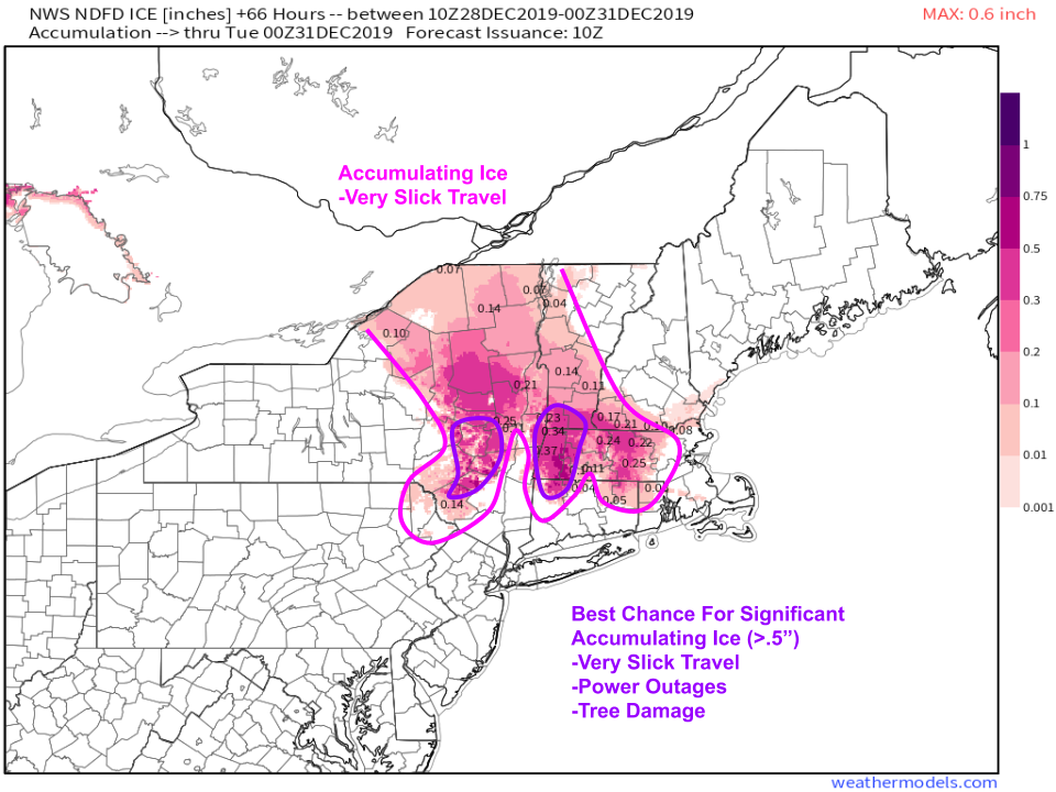
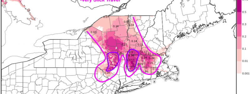
NWS freezing rain forecast products don’t yet cover the entire event, but the icy part of the system will be winding down by Monday evening, so this forecast graphic gets us pretty close to the event totals. A wide swath of accumulating ice is expected from this system, and I’ve highlighted my general area of concern in pink. Notice that I’ve taken that area a bit farther south across NE PA and NW CT in deference to the sticking power of the low level cold air which is often more resilient than forecast model guidance suggests. Pockets of the Berkshires and Catskills could be looking at a relatively significant ice storm event from this system with ice accretion values potentially exceeding 1/2″. This is more than enough to cause some tree/power line damage in addition to extremely slick roads.
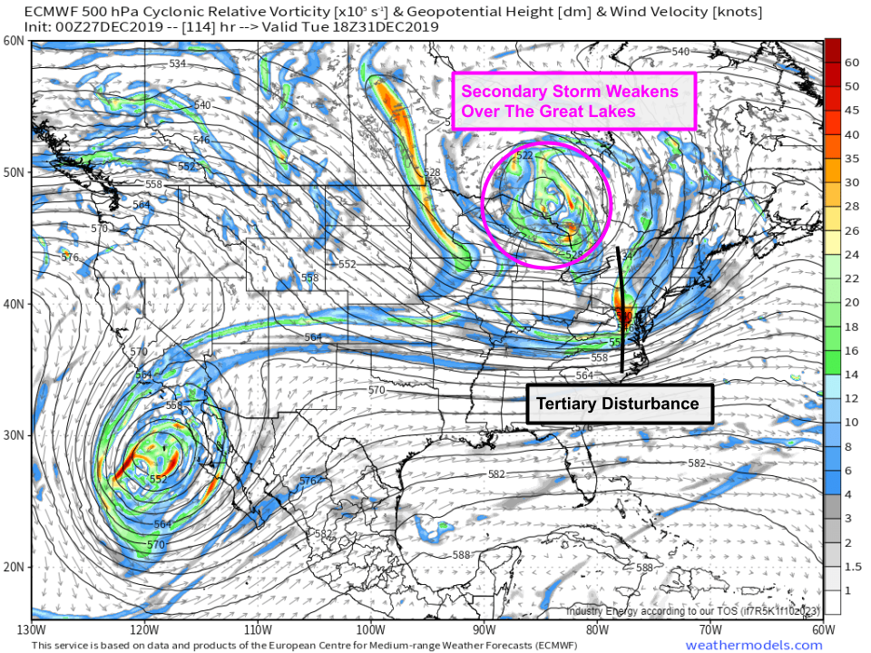
By the time we get to Tuesday, we’ll finally be entering phase three of the storm system’s evolution as a third disturbance swings around the base of the upper level low. This disturbance will touch off the development of a third storm off the Southern New England coastline which will strengthen as it moves NE into the Gulf of Maine. While this storm doesn’t appear to be nearly as intense as the first two iterations of the overall system, it will still be capable of bringing heavy snow to parts of Northern New England on Tuesday afternoon.
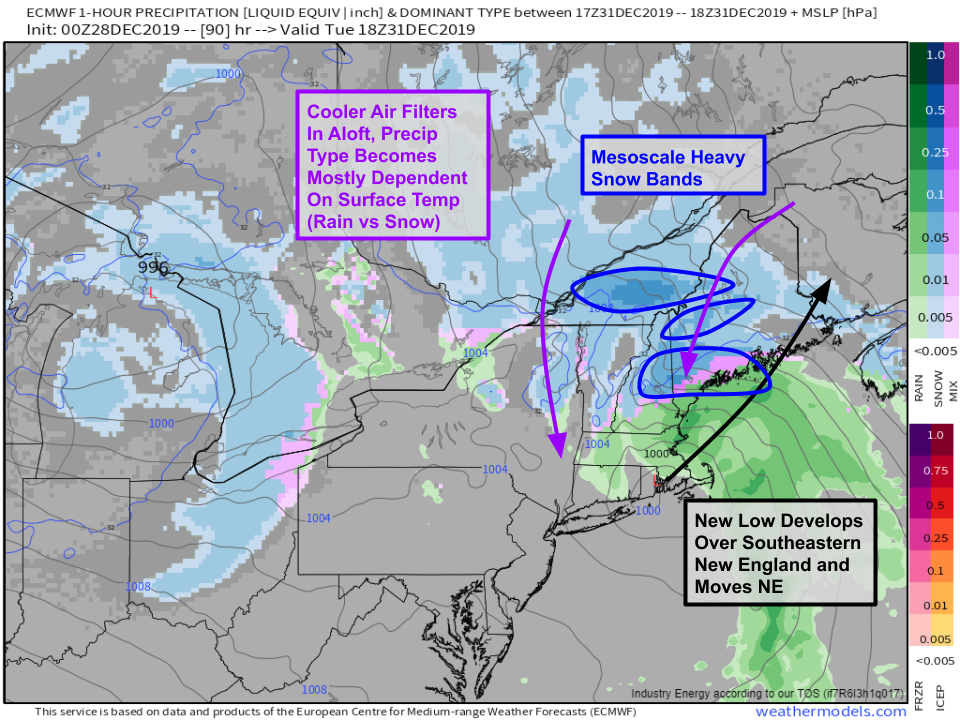
Here’s a look at the forecast for 2 PM EST on Tuesday as that new low moves into the Gulf of Maine. Bands of heavy snow will primarily impact NH and ME during this time, though the Green Mountains of VT could briefly see some heavier bursts of snow too. As cooler air moves south behind the developing storm, surface temperatures will become the main factor in determining precipitation types. This means that we’ll move away from the mixed bag of snow/sleet/ice and towards more of a rain/snow setup.
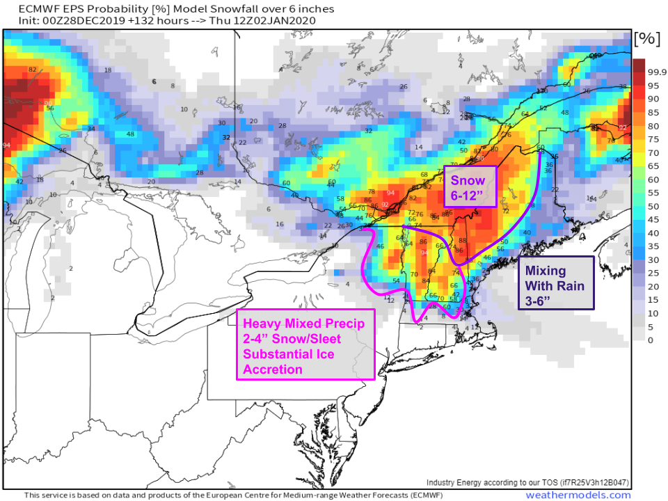
Here’s my best guess as to how much snow will fall from this system in New England. The EPS guidance I used as a backdrop for this graphic seems to be having some trouble differentiating snow from sleet/ice in VT/NY/SW NH, so take those values with a grain of salt. I think most of that area ends up with a couple inches of snow/sleet mixed in with the ice. If you’re looking for higher snow totals, head northeast into the White Mountains of NH or Maine where 6-12″ looks like a good bet. Lower amounts will be found along the Maine coast where warmer surface temps may inhibit snowfall accumulation somewhat, though there’s a good chance that this storm ends up coming in a bit colder than advertised by model guidance.
-Jack

