Opening Act of Multi-Stage Central/Eastern Storm To Bring Wintry Weather To Texas and Oklahoma Tomorrow
Hello everyone!
A complex storm system is developing in the Plains and Gulf of Mexico this morning. As the system slowly gets its act together today and especially tomorrow, it will bring a round of severe thunderstorms to parts of the Deep South including Louisiana, Mississippi, and Alabama. The severe side of this system was discussed in detail yesterday morning, and the thoughts there remain mostly unchanged. This post will focus on the beginning of this system’s wintry aspect as snow and ice develop in Texas tomorrow.
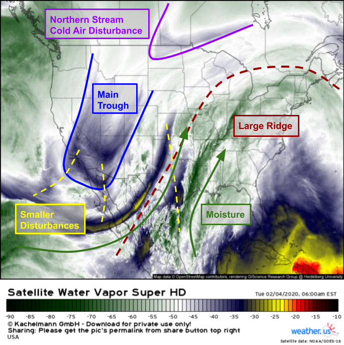
As per usual, we’ll start with a look at GOES-East WV imagery. The main trough responsible for this week’s storm is clearly visible over the southern Rockies while several smaller disturbances rotate around that trough’s base. Moisture taps from the Gulf of Mexico and Eastern Pacific are clearly evident as well, and that moisture will be important for both sides of the system (the severe and the wintry). Finally, we have a disturbance digging into North Dakota that’s directing a pocket of not-quite-Arctic air southeastward. Unfortunately for those looking for a big winter storm, a large ridge is present over much of the East Coast. The incoming cold air will basically bounce right off this ridge and head east into Canada instead of southeast into New England. That means that while northern New England will see a bit of this cold air, most spots along the storm’s track won’t have access to “real” cold air, and will have to make do with a modified polar airmass.
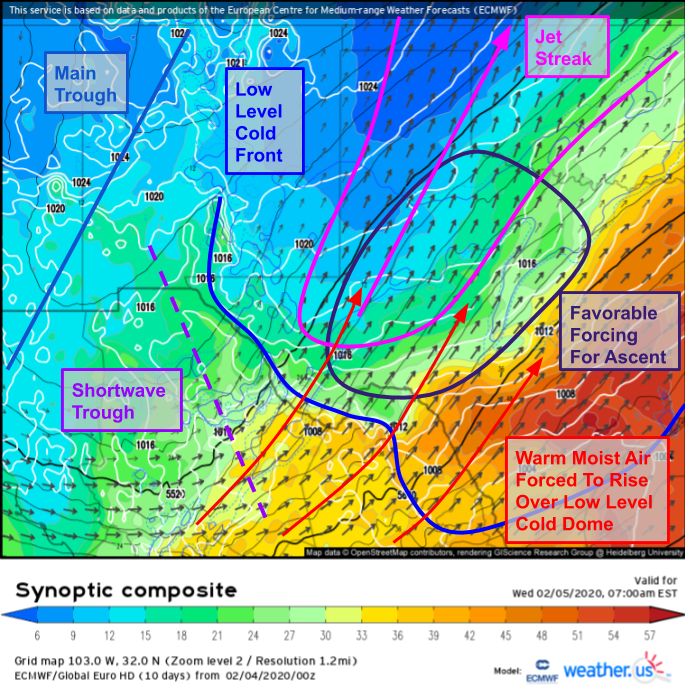
Here’s a look at the ECMWF’s Synoptic Composite forecast (click here for a tutorial on the synoptic composite) for the Texas area tomorrow morning, when the first round of substantial wintry precipitation is expected to develop. To get snow, you need cold air, moisture, and forcing for ascent which just means something to force air parcels to rise. After a strong cold front moves through Texas today, we’ll have enough cold air (especially over the Panhandle/north-central parts of the state). As one of the shortwave troughs we noted on satellite imagery moves northeast out of Mexico, we’ll have several mechanisms to drive forcing for ascent. The first will be isentropic uplift as warm moist air is forced to rise up and over the low level cold airmass. The second will be dynamic lifting associated with the right entrance region of an upper level jet streak. The third will be the lift associated with the approaching trough (both shortwave and longwave). We already saw the moisture feeds lined up on satellite imagery this morning. Based on this analysis, we can conclude that an area of steady precipitation (possibly snow, depending on temps) is likely to develop over Central Texas tomorrow morning.
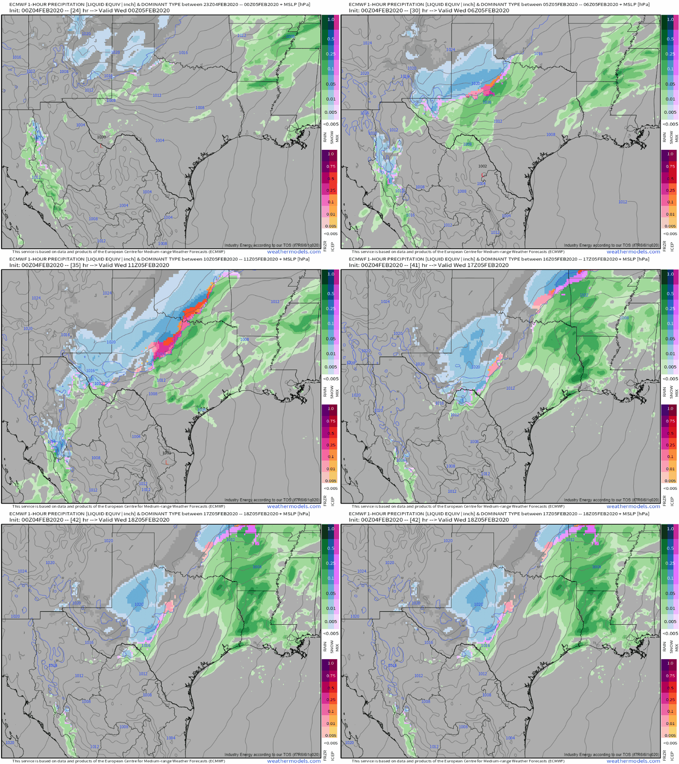
Sure enough, that’s exactly what model guidance is forecasting. We still need to nail down where exactly temps will be cold enough for snow, but we’ll have an area of steady precipitation to work with across roughly the northwestern half of Texas (remember, we’re not focusing on the thunderstorms over Eastern Texas in this post).
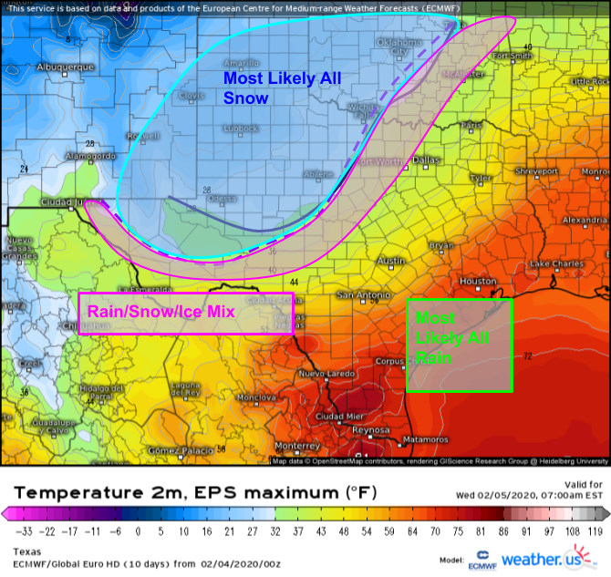
By looking at EPS forecasts for 850mb temps and surface temps, we can highlight the areas most likely to see all snow, all rain, or some mix of both. If a given location was forecast to remain below 0C at 850mb and below 34F at the surface, I put it in the “most likely all snow” category. If a given area was below 0C at 850mb in some but not all EPS simulations, or if surface temperatures were forecast to be below 32F in some but not all EPS simulations, I put it in the “Rain/Snow/Ice mix” category. If all EPS simulations agreed on a given area remaining >34F at the surface, I put it in the “most likely all rain” category. Of course this isn’t meant to be town-by-town precision, but it gives us a good idea of which general areas are most likely to experience rain, snow, or a mix of both.
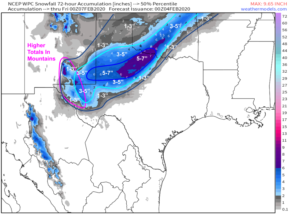
As far as accumulations go, here’s the “most likely” solution as determined by the WPC’s snowfall prediction ensemble system. I’ve tweaked the values a little bit based on my analysis (mostly over southern OK, where I don’t think there’s robust support for >6″) but otherwise that map looks pretty good. Snow will depart the TX/OK area tomorrow night as the storm moves up the Ohio Valley.
I’ll discuss this storm’s wintry impacts from Missouri to Maine in more detail tomorrow morning.
-Jack
