Nor’easter To Bring Rain And Mountain Snow To The Northeast Tomorrow Through Saturday
Hello everyone!
What’s in the forecast for the end of this week and the first part of the upcoming weekend is something we surprisingly haven’t seen much of this winter: a nor’easter. Fortunately for those who point out that yesterday was the first day of spring, any wintry weather associated with this system will be confined to the higher elevations of New York and New England. With that said, the heavy wet snow expected from this system along with gusty winds will make it fairly impactful for those areas. Along the coast, breezy onshore winds combined with astronomically high tides are likely to result in some coastal flooding concerns.
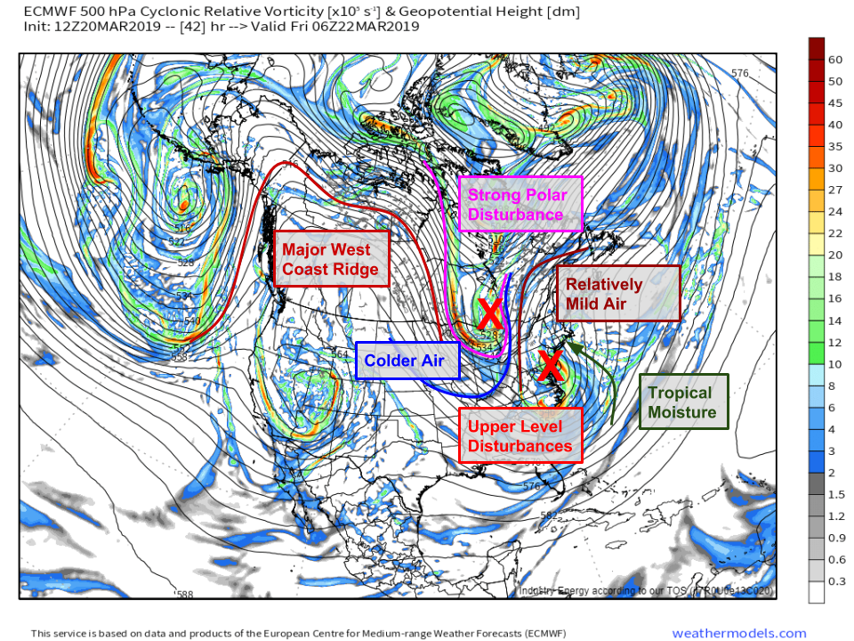
Here’s a look at the large scale upper level setup visualized by the ECMWF’s 500mb vorticity forecast for tonight. The first feature to notice is the large ridge of high pressure over the West Coast. What goes up must come down, and that ridge will force a strong polar disturbance south through Canada to carve out a trough of low pressure over the East Coast. This process will involve the merging of two upper level disturbances, the aforementioned polar system and a system embedded in the southern branch of the jet stream over the Ohio Valley. The northern system will bring the cold air, while the southern system will bring the moisture. Thankfully for those who are not a fan of winter weather, the cold air will be lagging the moisture a bit so this one’s all rain for the coastal plain. 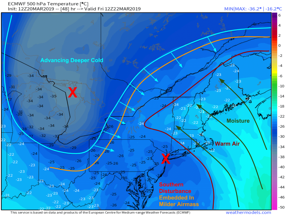
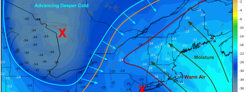
Here’s a better visualization of why this storm will be rain at lower elevations, even for areas N/NW of the low’s track. The whole southern disturbance is embedded within a mild airmass, so there’s no nearby cold air to feed into the storm. It’s only once the northern disturbance over the Great Lakes moves in and merges with the overall system that the storm will be able to tap a cold airmass. Meanwhile on the eastern side of the storm, warm moist air will be flowing in from the Atlantic. Curious why I’ve labeled temperature values in the low -20’s as warm? This map shows the temperature for 500mb, or about 25,000 feet. Of course it will be much warmer at the surface!
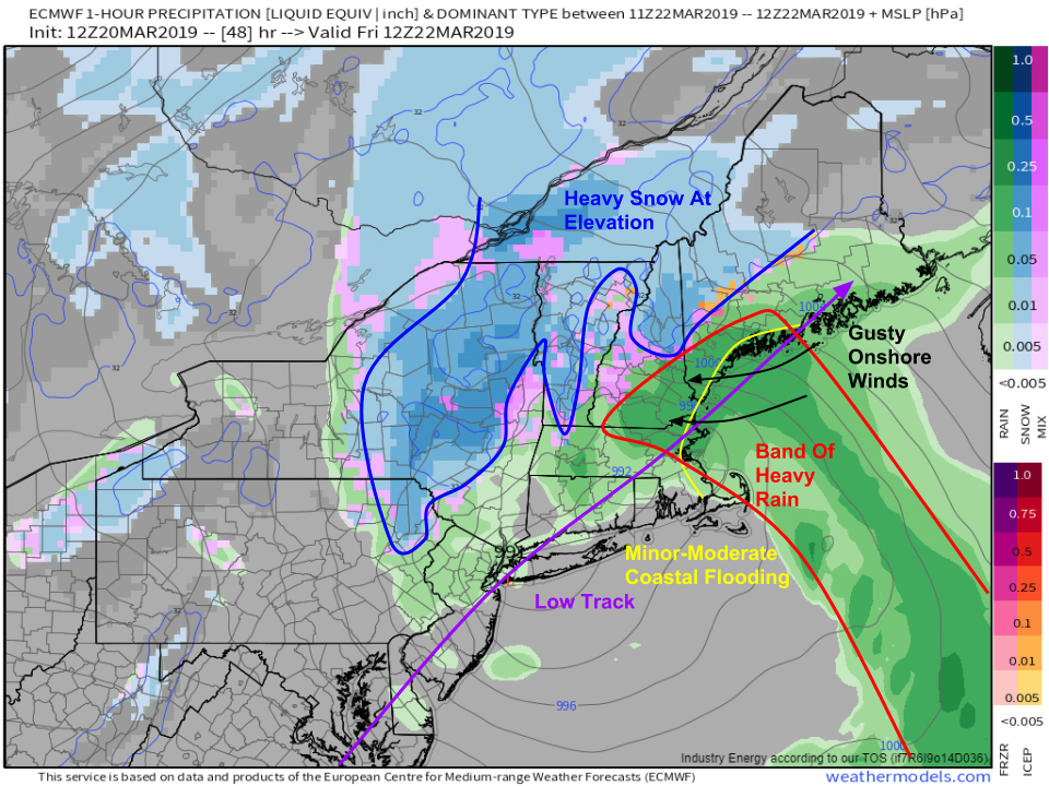
Here’s a look at what those upper level dynamics translate to at the surface. A band of heavy rain will propagate to the northeast ahead of the storm’s center, while cold air will start to wrap in the back side of the system supporting snow in New York. Note that the areas expecting snow are the higher elevations of ME, NH, and VT with only some lower elevation parts of New York seeing some flakes. Snow related impacts from this system will be highly elevation dependent! One other thing to keep an eye on will be gusty onshore winds that result in some minor-moderate coastal flooding along east-facing shores of ME, NH, and MA.
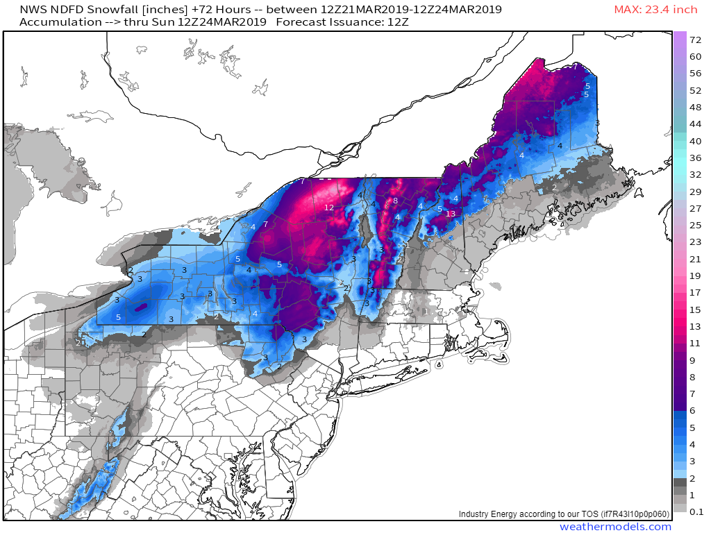
Here’s the NWS’s forecast for snow totals through Sunday morning, and it reads like a topographical map for a reason. With that milder airmass in place, you’ll need to head upwards in elevation to get temps cold enough for snow to stick. The result will be some impressive snowfall gradients, with totals ranging from perhaps an inch on the shores of Lake Champlain to 18″ just a few miles away in the Green Mountains.
Here’s a look at the system this morning as it moves up through North Carolina. Note the band of thunderstorms located off the Outer Banks. These storms are indicative of the northward transport of warm moist air, which is already helping to support bands of heavy rain across VA and MD. Be sure to follow along with the system as it moves NE via HD radar and GOES-East satellite products. Remember you can click any map to zoom in, and navigate to other types of imagery via the menus to the left of the image.
-Jack
