Nor’easter Likely To Bring Christmas Morning Snow To New England
Hello everyone!
White Christmas dreams are likely to come true for folks in New England as a rapidly developing Nor’easter brings a quick but heavy burst of snow just in time for Christmas morning. This will be a fast moving system, but will produce snow heavy enough to see decent accumulations in a short period of time. The heavier snowfall rates will mean dangerous travel with low visibilities and snow covered roads as plows struggle to keep up with swift accumulations.
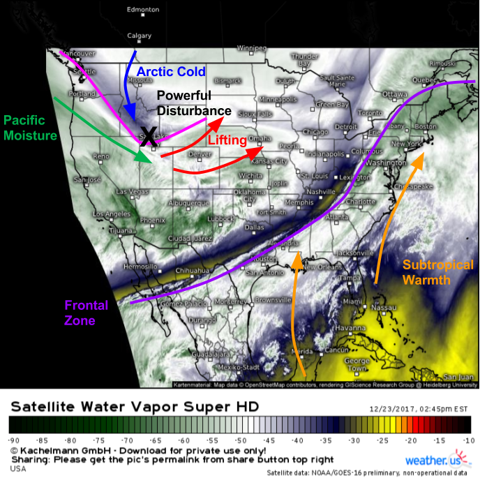
Water Vapor satellite imagery (what’s that?) shows the key players for this storm already moving into position across the US this afternoon. The primary feature to watch will be a very strong Arctic disturbance that is driving SE through the Rockies. I discussed this feature briefly this morning, as it has been bringing heavy snow to parts of Colorado and Wyoming today. This disturbance will continue to move SE then E through the Southern Plains tonight, and light snow will develop as lifting begins along and to the north of its track.
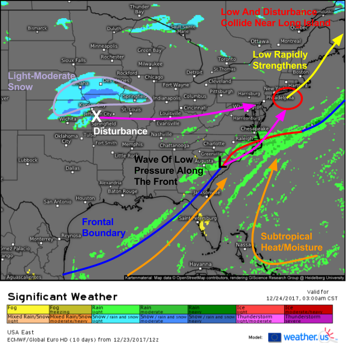
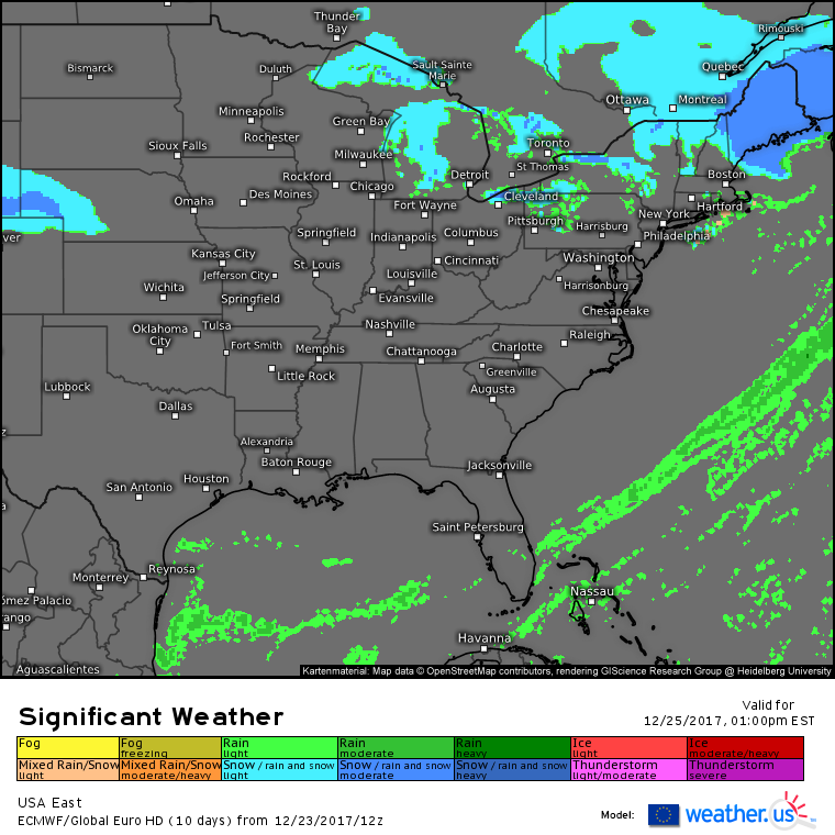
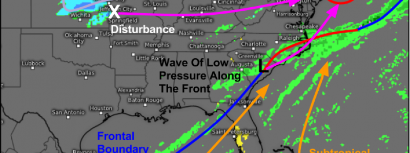
Here’s a look at the forecast significant weather for very early tomorrow morning. You can see the light-moderate snow associated with the disturbance moving through parts of the Central Plains. The portion of the system that has all the moisture will still be removed from the disturbance tomorrow morning, so heavy snow isn’t expected, but a quick 1-3″ of snow is possible in parts of Kansas, Nebraska, Missouri, Iowa, and Illinois. It won’t be until the Arctic disturbance makes contact with a wave of low pressure forming along a stalled frontal boundary that we really get the strong dynamics.
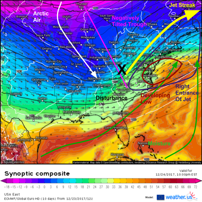
The ECMWF’s synoptic composite map (what’s that?) puts it all together in terms of the dynamics to watch for tomorrow evening. By 10 PM, the Arctic disturbance will be interacting with the frontal boundary left from today’s storm. As a result, a low will develop off the Mid Atlantic coast, and immediately become the beneficiary of several very strong dynamic features. It’ll have the Arctic disturbance leading a strong negatively tilted trough towards the coast. It’ll be sitting in the right entrance region of a strong anticyclonically curved jet streak. It’ll sit right on the boundary between subtropical warmth and Polar cold, a powder keg of potential energy that will be released thanks to the Arctic disturbance.
So what does all of that mean for the sensible weather in the eastern third of the country?
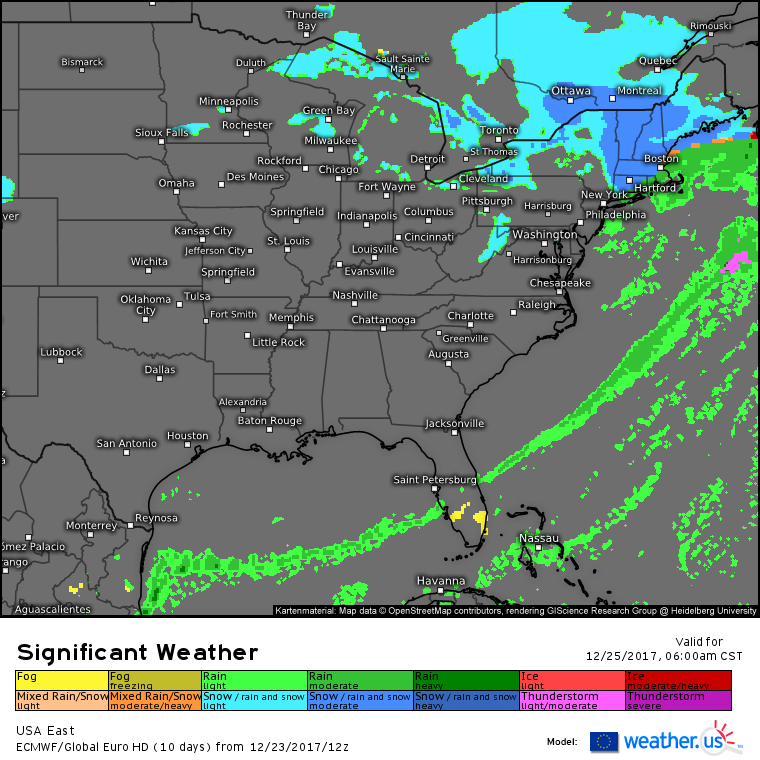
I mentioned above how the Arctic disturbance would produce a swath of light-moderate snow even before it encountered the moisture laden frontal boundary. The ECMWF’s forecast for tomorrow afternoon shows that area of light-moderate snow impacting parts of Indiana, Michigan, and Ohio as the disturbance plows through Kentucky. If you’re travelling through these areas tomorrow, use caution. Otherwise, weather will generally be quiet through tomorrow evening so use that time to get wherever you want to be on Christmas morning.
By tomorrow evening, we’ll be able to see the effects of the dynamics discussed above beginning to take shape. You can clearly tell that the Arctic disturbance is moving through the Pittsburgh area, and that it’s beginning to draw moisture from the frontal zone northward. This bridging of the gap between the energy and the moisture will result in light to moderate rain and snow breaking out in places like New York City and Philadelphia, though only a coating-2″ is expected at most before warm air invades and results in a change to rain for the whole NYC-DC corridor.
As we wake up on Christmas morning, the dreams of kids across most of New England will be coming true as the Arctic disturbance works its magic on the frontal wave. Heavy bands of snow will be impacting much of interior Southern New England as well as parts of Vermont, New Hampshire, and Southern Maine. The coastal low will be intensifying over Cape Cod, and will draw warm air inland across parts of RI and SE MA, as well as coastal CT. This warm air will be enough to change snow to rain, limiting accumulation potential. There’s still a little bit of uncertainty as to exactly where the storm’s redevelopment occurs and how fast that process unfolds, which will be the ultimate determiner of the rain/snow line.
By Monday afternoon, the storm will be all wrapped up for everyone except Maine. Gusty winds will kick in behind the storm as a very cold airmass begins to move south out of Canada. While travel Monday morning is definitely not recommended, you won’t have to wait long for the storm to move out and roads to be cleared off. Even Maine will see snow taper to flurries by Monday evening. It’s the fast moving nature of this storm that will prevent totals from getting too high as we have all the dynamics needed for very heavy snow.
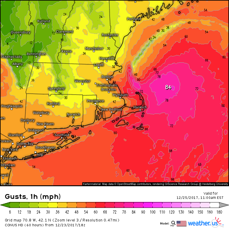
As the storm rapidly intensifies, winds will kick up due to the falling pressures. This map is one idea of how winds could intensify on the back side of the storm. The strongest winds will be SW of the low’s center, located just offshore of Boston. This means that Cape Cod, SE MA, and Long Island are in the jackpot zone for high winds, which will be gusting over 50 mph at times. Thankfully the coastal areas that will see the worst winds on Monday aren’t the same areas that saw the worst of the ice today. That being said, 30-40 mph gusts with trees still coated in ice from NE MA through SE NH and SW ME won’t be a good situation. Watch for a continued power outage threat in those areas due to the combo of leftover ice and strong winds.
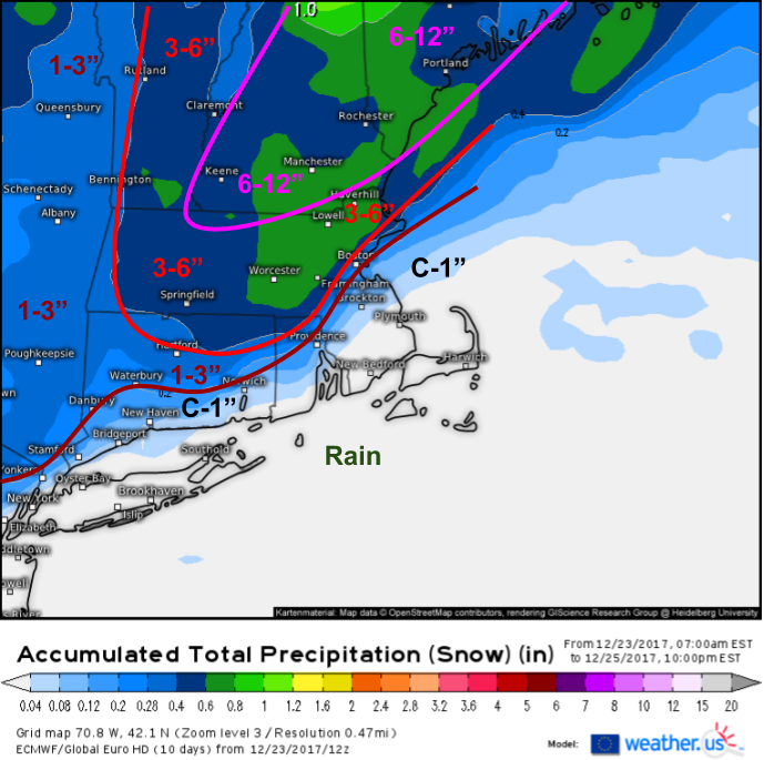
How much snow am I expecting from this system? This map should give a good idea. The area from Boston to Providence is the hardest forecast at the moment, because snowfall totals in that area will depend entirely on the exact location of the rain/snow line. If that boundary ends up 30 miles east of where it’s forecast, folks along the I-95 corridor will see quite a bit more snow than forecast. The opposite will happen if that line shifts NW. Regardless, the jackpot for this storm will lie in New Hampshire and Maine where 6-12″ are expected. These higher amounts are due to the stronger dynamics available from a stronger storm, and the storm will indeed be stronger when it impacts these areas.
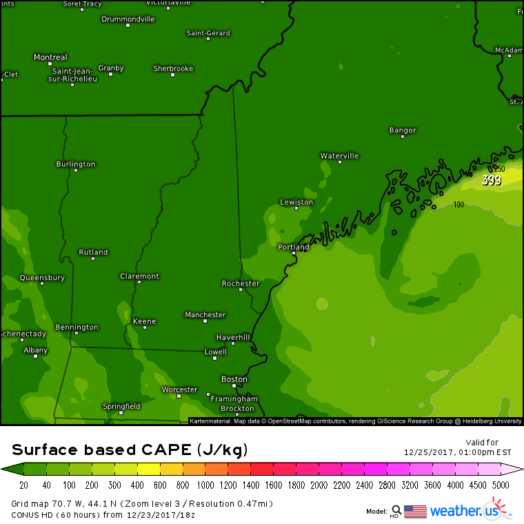
One final interesting part about this storm will be the potential for thundersnow under a very strong banding feature forecast to set up near Portland Maine. This map shows the amount of convective instability forecast midday on Monday. Notice the non-zero values extending from Portland to Lewiston. With very strong upward motion, this instability could be just enough to allow for a rumble or two of thundersnow before the storm pulls away.
-Jack
