Most Memorable Weather Events of 2022, Part One
The year 2022 was a bit of an odd one in terms of impactful weather. From an initially extremely inactive hurricane season to very few “large” weathermakers, it’s a bit difficult to come up with a top ten in terms of 2022 large-scale events. This year was quite a bit about smaller events that made large impacts: heatwaves, extreme (localized) flooding, and what became a sprawling drought.
We’ve decided to split this year’s end-of-the-year blog into two parts. You’ll read about the aforementioned floods, heatwaves, and droughts in part 2 of our blog, written by Armando.
In this blog (part one), I’ll recap some of the larger-scale events we’ve seen this year.
New Years Eve 2021/New Years 2022

The New Year kicked off with a bang as a powerful system rolled across the country. Arctic air filtering in from the north clashed with an unusually warm/moist airmass parked over the southern part of the country.
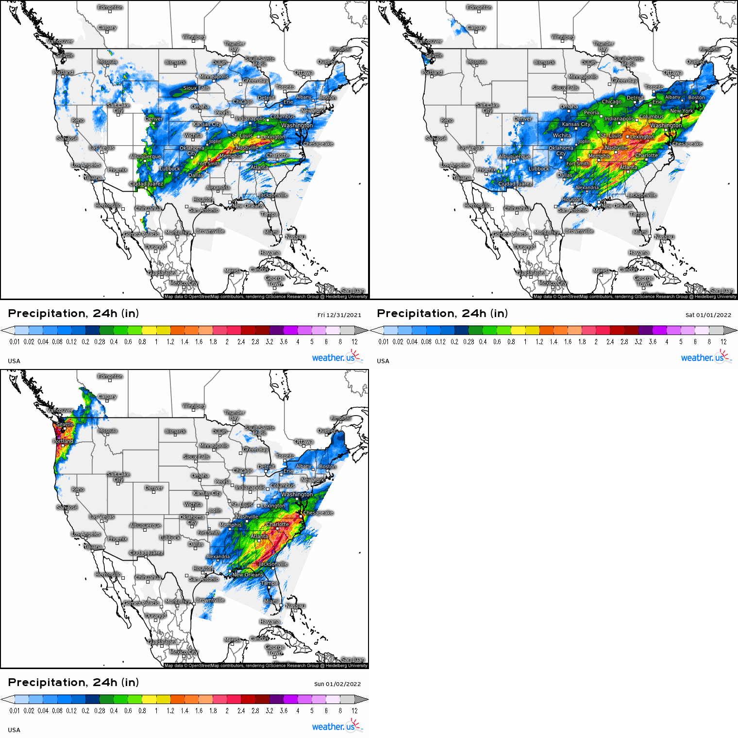
In the warm sector, severe weather was seen from the Tennessee/Ohio Valley regions into the Southeast. Several tornadoes rolled across Kentucky, Tennessee, Alabama, and Georgia. Reports of damaging winds were much more widespread. Heavy rain fell ahead of the front, resulting in localized flooding.
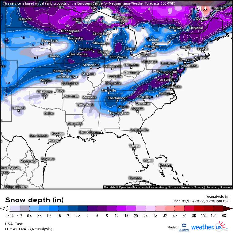
In the cold sector, frigid air rushed in quickly behind the front, allowing rain to turn to snow over some of the same areas that had received severe weather the day before. The heaviest totals were found along the Central/Southern Appalachians and into the Mid-Atlantic. Over a foot fell in places like Maryland, Virginia, Delaware, and New Jersey while totals exceeding 6 inches were found as far south as Northern Alabama.
January Nor’easter
The winter of 2021/2022 rolled on with a few more relatively minor snowfall events after New Years. As we approached the end of January, however, it became apparent that something big was looming. That “something” was a nor’easter.

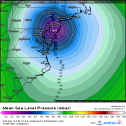
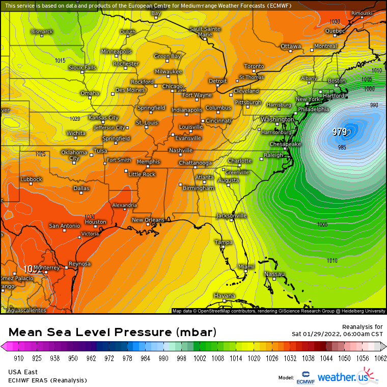
To create this storm, the southern jet stream phased with the northern jet stream just offshore of the East Coast. The result was a powerful, rapidly deepening low. This low “bombed out,” deepening roughly 38 millibars in just 12 hours. As it did so, it began honing in on New England.
As the low approached, strong high pressure centered over eastern Canada pumped sub-freezing air into the Northeast, assuring that this event would be mainly snow.
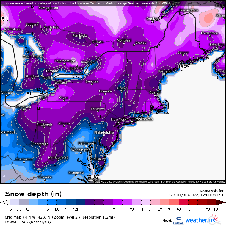
The deepening storm pounded areas from the Mid-Atlantic to New England with heavy snow. Massachusetts was hardest hit with nearly two and a half feet of snow recorded in some areas and widespread reports of 18 to 24 inches elsewhere.
Additionally, intense winds associated with the deepening cyclone pummeled the coast, resulting in blizzard conditions, coastal flooding and power outages. Hurricane-force wind gusts were observed in Massachusetts while widespread tropical storm force gusts were observed in other areas of New England such as Maine and Rhode Island.
March 5th Midwest Severe Event
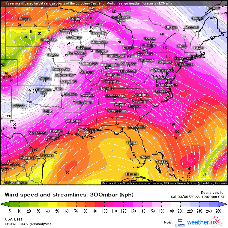
As the calendar slowly rolled toward Spring, severe season materialized quickly as we entered into March. However, it kicked off in a rather unlikely place – the Midwest.
A potent shortwave dug in over the Central Plains, tilted negatively, and then ejected northeastward across the Midwest.
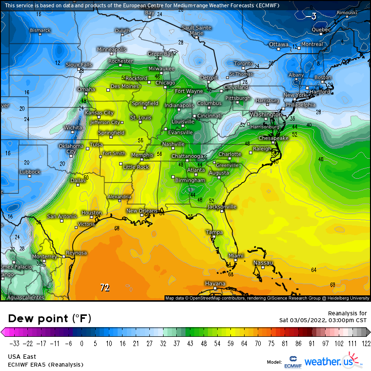
As the surface cyclone deepened and the low-level jet increased, anomalously warm/moist air – at least for this region during this time of year – shot northward. Though moisture was modest at best, steep lapse rates and the forcing of the incoming cold front worked together to produce an arcing band of convection.
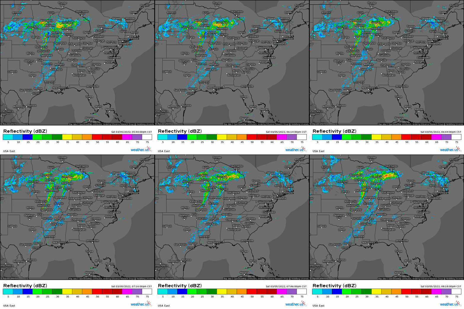
Though damaging winds were the initial concern, the event uptrended the day of as more instability than previously forecast materialized.
Discrete supercells were able to form in the early stages of the event. A tornado outbreak ensued.
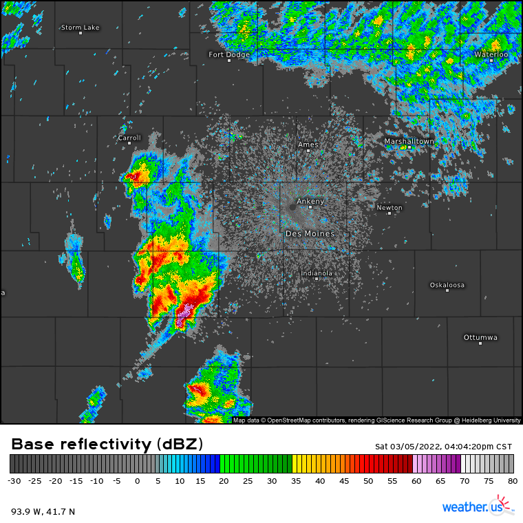
Over the course of the entire event, 32 tornadoes were confirmed. Most notable among these was a long-track EF4 that was on the ground for just over 70 miles in Iowa. Unfortunately, this tornado alone was the cause of 6 deaths.
As the evening rolled on, damaging winds became the primary hazard. Wind reports poured in from Iowa to Wisconsin to Ohio as the evening rolled on.
This system would go on to produce another widespread damaging wind event in the Northeast just two days later.
March 29-31 Severe Weather Outbreak
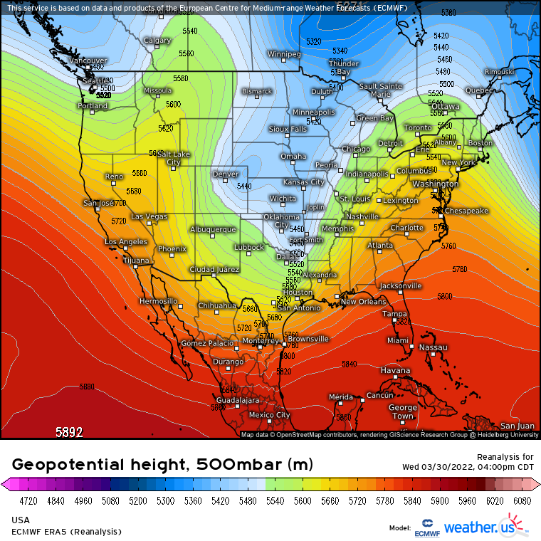
At the end of March, an upper-level trough descended over the Central US. While digging down toward the southern US, a potent shortwave rounded the base of the trough, intent on causing mischief.
An associated surface low deepened, pulling warm/moist air northward. Strong vertical shear was in place as well, and conditions were conducive to severe weather.
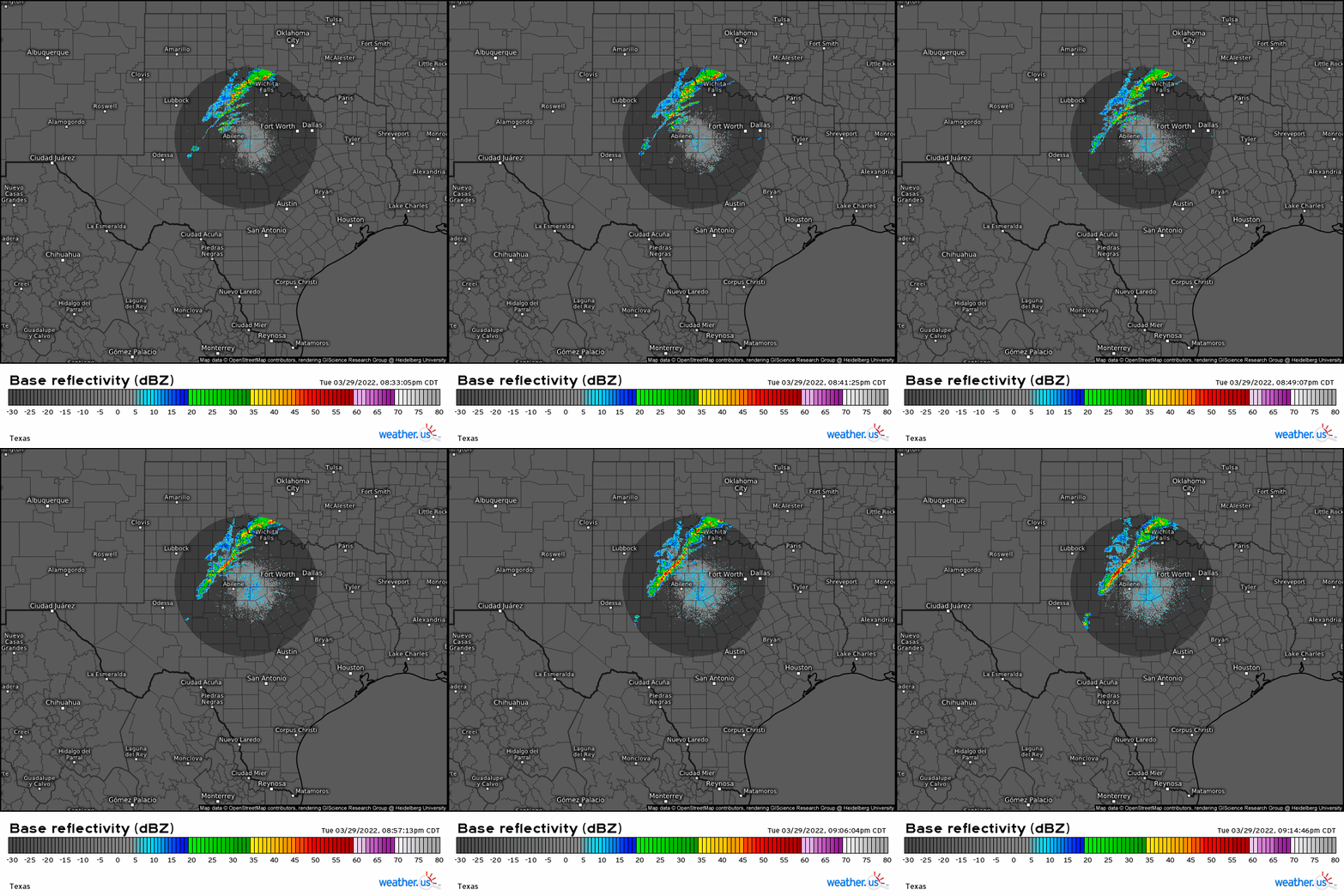
In the evening hours of March 29, the dryline pushed eastward across western Texas, and convective initiation occurred.
Scattered severe weather resulted from this line, mostly over the eastern parts of the Plains in the overnight/early morning hours. But the true severe outbreak would occur the next day.
On March 30th, with strong vertical shear already in place, it wasn’t long before broken cloud cover provided a match to the existing tinder in the form of instability. As the squall line moved into more favorable conditions, severe weather reports exploded.
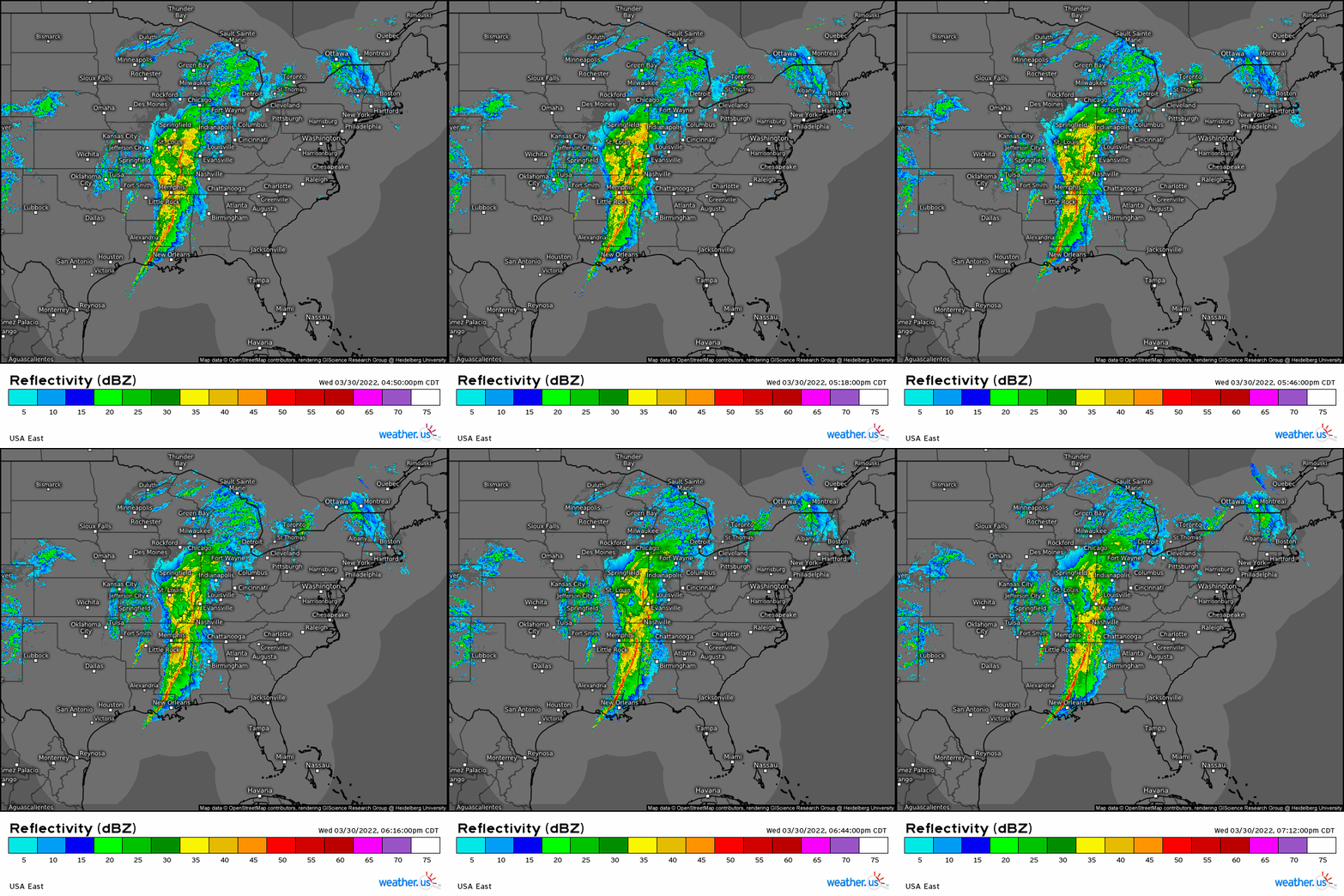
Ahead of the line, discrete cells were able to form and eventually put down more than a few tornadoes in addition to widespread damaging winds.
Over the course of the 3-day event, many tornadoes occurred, but three of these were rather significant.
The first was an EF3 that occurred in the early morning hours near Fayetteville, AR. Plenty of damage was reported, but no deaths occurred.
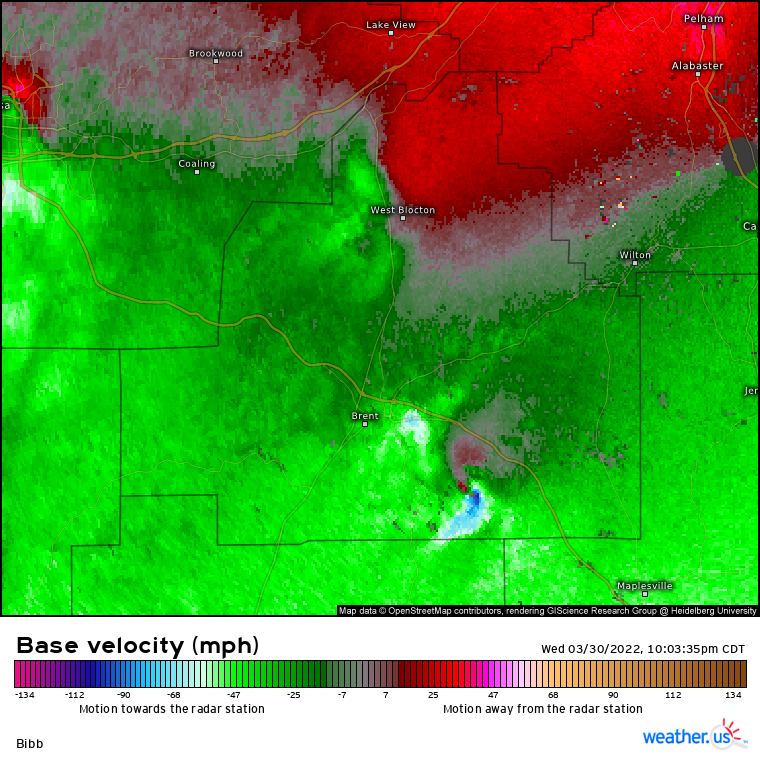
The second was a long-track EF3 in Central Alabama. This tornado began near Brent, AL and tracked just over 29 miles before dissipating near Montevallo, AL. Fortunately, the most intense damage was seen in forested, unpopulated areas, though several buildings and homes were damaged along the way. No deaths were reported.
The third occurred in the early morning hours of March 31. A tornado with the maximum intensity of EF3 and a path length of just over 12 miles formed near Wausau, FL and lifted a little while later near Cottondale FL. Intense damage was done to homes along the path and, unfortunately, two deaths were recorded.
When all was said and done, the three day event resulted in 90 confirmed tornadoes and over 300 wind reports from Texas to far southern New York.
Hurricane Ian
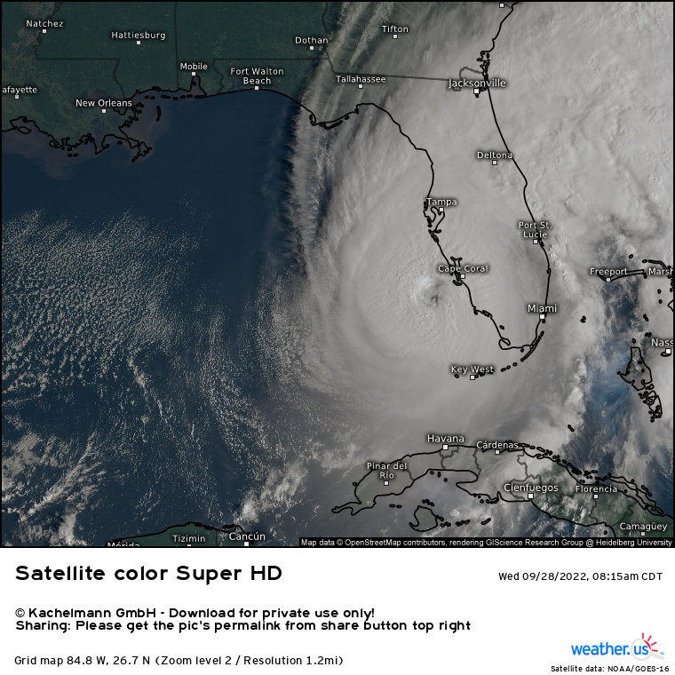
Severe season rolled on as the calendar edged toward summer. Though a few notable events occurred in the late spring, attention began to turn toward the onset of hurricane season as it was predicted to be another hyperactive year.
However, dry air continually plagued the Atlantic basin through the usually-active months of July and August. Any wave that seemed to have potential was either choked by dry air or sheared apart. Rumors of a “bust” year began flying. But, as a very wise professor once told our forecasting class, “It only takes one to make it a memorable year.” And we certainly got that “one.”
The disturbance that would become Hurricane Ian began as an African Easterly Wave that started its journey across the Atlantic on September 14. A hostile environment kept it from organizing at first. But, roughly 5 days later as it approached the Windward Islands, it was tagged for potential development by the NHC.
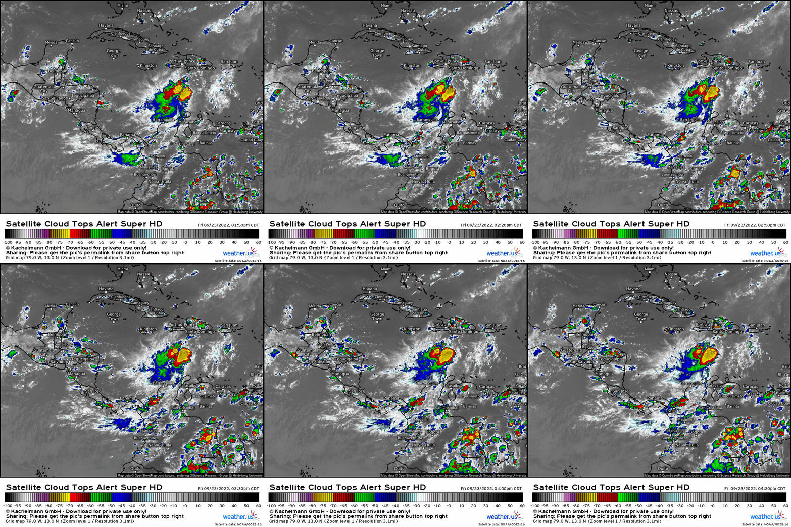
On September 23, the disturbance, now located in the Caribbean, had organized enough to be designated Tropical Depression Nine. Less than 24 hours later, it was upgraded to Tropical Storm Ian.
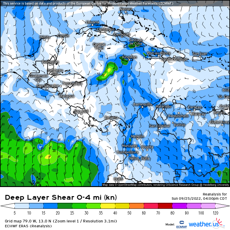
Bathtub-warm waters and very little shear offered Ian the perfect environment in which to attempt rapid intensification. By September 27, Ian was a category 3 hurricane as it made landfall in western Cuba.
The fairly narrow, relatively flat terrain of the western portion of Cuba offered little resistance to Ian, which emerged relatively unscathed into the Gulf of Mexico just a few hours after landfall.
At this point, it was clear that Ian had it’s eyes set on Florida. However, uncertainty in the forecast regarding interaction with a trough sweeping eastward across the US lead to greater-than-average uncertainty about just where in Florida landfall might be.
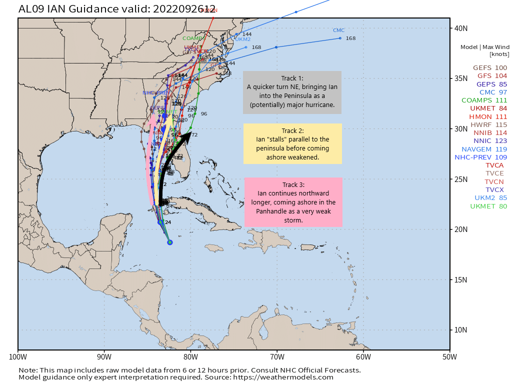
For a decent amount of time, Track 2 (as displayed above) was the favored solution. It was believed that Ian would nearly stall just offshore of the Tampa Bay area, bringing the largest impacts to the Bay area before coming ashore just north of the region.
However, a faster-moving trough resulted in a quick adjustment to Track 3 as the favored solution, shifting the focus from Tampa Bay to the Fort Myers area. Frantic preparations were made.
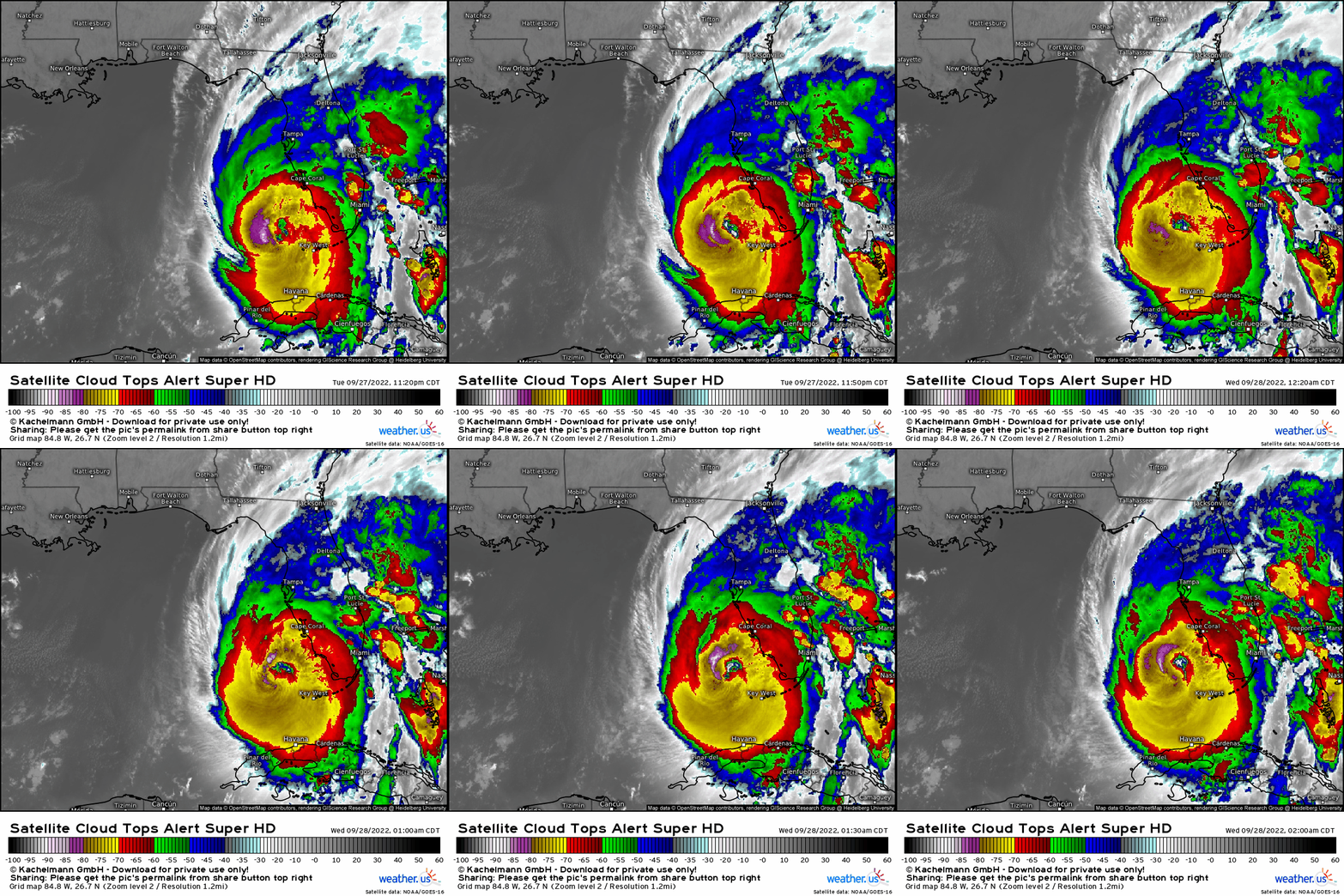
Meanwhile, Ian had taken advantage of its environment and become a powerful, high-end category 4 hurricane.
Eye-popping forecasts were issued. Peak surge heights of 8 to 12 feet were predicted. A foot and a half of rain was forecast for parts of the Florida peninsula. Some evacuated. Tragically, some did not.
On September 28, 2022 at 3:05 pm, a strong category 4 Hurricane Ian made landfall near Cayo Costa, Florida. With a central pressure of 940 mb and sustained winds of 150 mph, the effects were devastating.
Extreme wind warnings were issued. Flash flood emergencies occurred. An extremely destructive storm surge of 10 to 15 feet was observed in Naples, Fort Myers Beach, and the surrounding areas. Causeways to and from islands just offshore were flooded over, cutting off access to the mainland and help. Unfortunately, nearly 150 people died in Florida alone due to Hurricane Ian.
Ian’s journey didn’t end there.
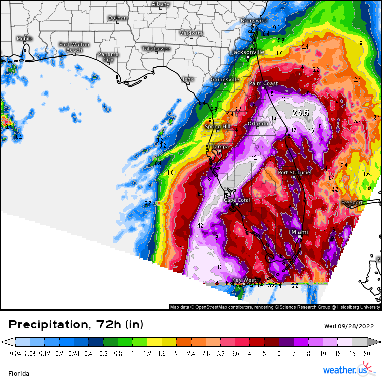
Ian crossed the Florida peninsula, dumping an incredible amount of rainfall along the way. Just a day after landfall, Ian exited northeast Florida and entered the Atlantic Ocean as a tropical storm.
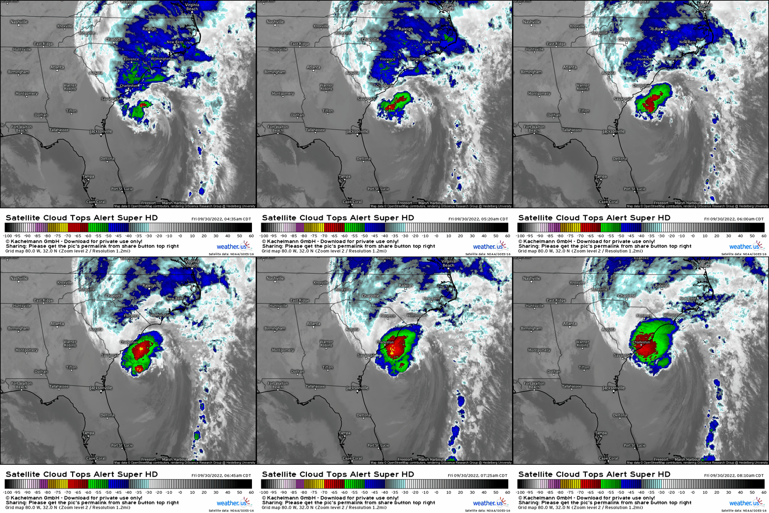
Though its satellite presentation was a bit of a mess, Ian was able to reorganize enough to once again attain hurricane status as a category 1. It made its final landfall near Georgetown, SC on September 30.
Though Ian weakened quickly after landfall, its effects were felt far and wide.
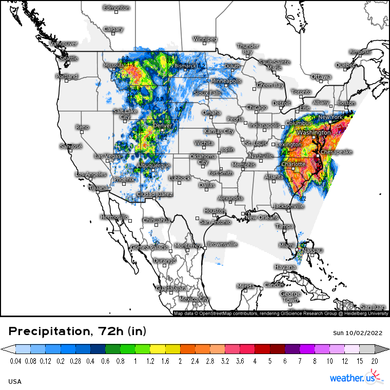
Ian’s moisture streamed northward, inundating the Mid-Atlantic region. Additionally, Ian’s remnant low stalled offshore of New Jersey for several days. Strong winds, heavy rains, and coastal flooding resulted.
Hurricane Ian was the deadliest hurricane to impact Florida since the 1935 Labor Day Hurricane. It will undoubtedly be remembered for a long time.
Hurricane Nicole
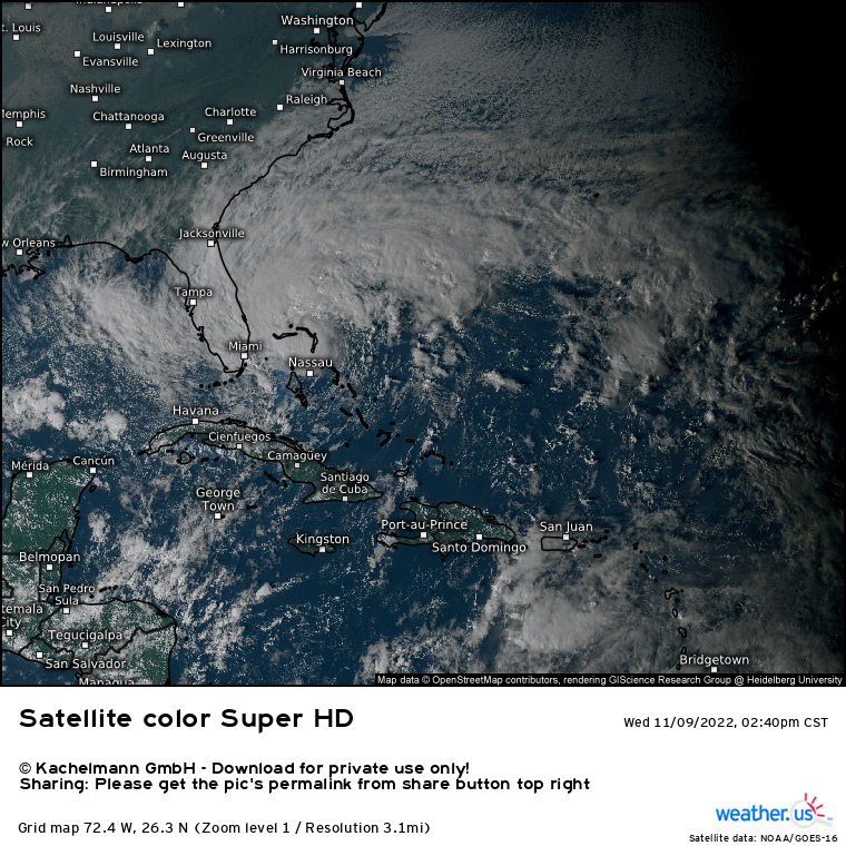
The 2022 Hurricane Season may have had a “late” start, but despite an already-devastating direct hit on Florida, the 2022 season wasn’t done with them just yet.
Hurricane Nicole was a late season storm that began as a subtropical low in the southwestern Atlantic in early November. It was a large storm, as these lows often are. Even though it was forecast to track over some rather warm waters, its size made rapid intensification unlikely. The warm waters did, however, help it fire enough central thunderstorm activity to transition from a subtropical storm to a tropical storm.
Nicole made a brief landfall on Great Abaco Island in the Bahamas on November 9th. As its center re-emerged over water, it set it sights on Florida’s east coast.
As Nicole tracked over warmer waters between Florida and the Bahamas, it was able to strengthen into a Category 1 hurricane. However, its size and dry air/substantial shear in the vicinity kept it from strengthening further.
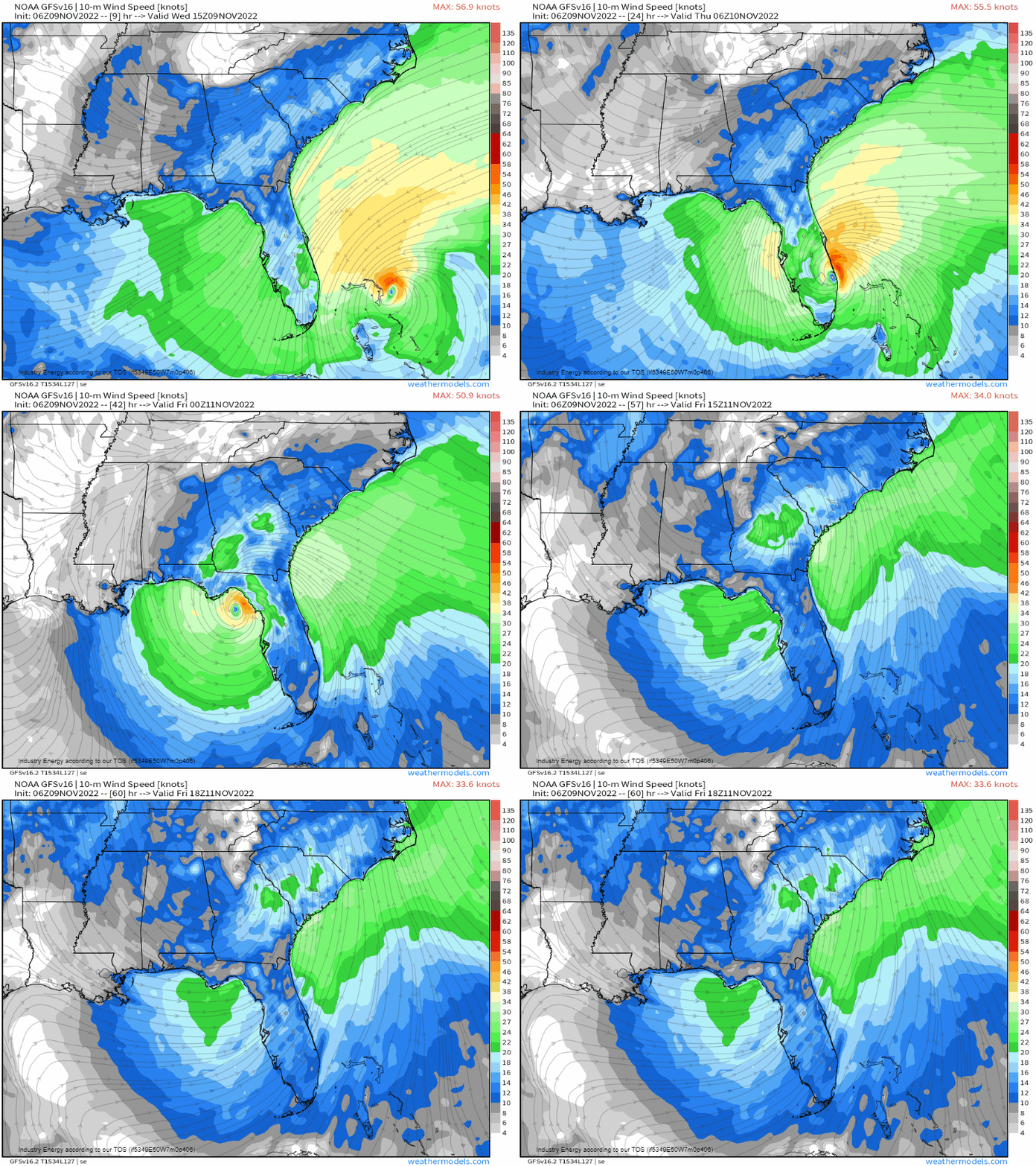
Still, Nicole was large and, despite the fact that it was “only” a Category 1, its effects were felt far from the center.
Nicole’s large wind field facilitated a prolonged onshore push of water for Florida’s eastern coast. The affected area, which had just been impacted by Hurricane Ian not six weeks earlier, saw structures weaken and crumble under the relentless onslaught of the ocean. Though surge levels were only recorded between 3 and 5 feet, hundreds of millions of dollars in damage was done.
Additionally, though the center of Nicole was located near Florida, its size allowed for storm surge reports as far north as South Carolina.
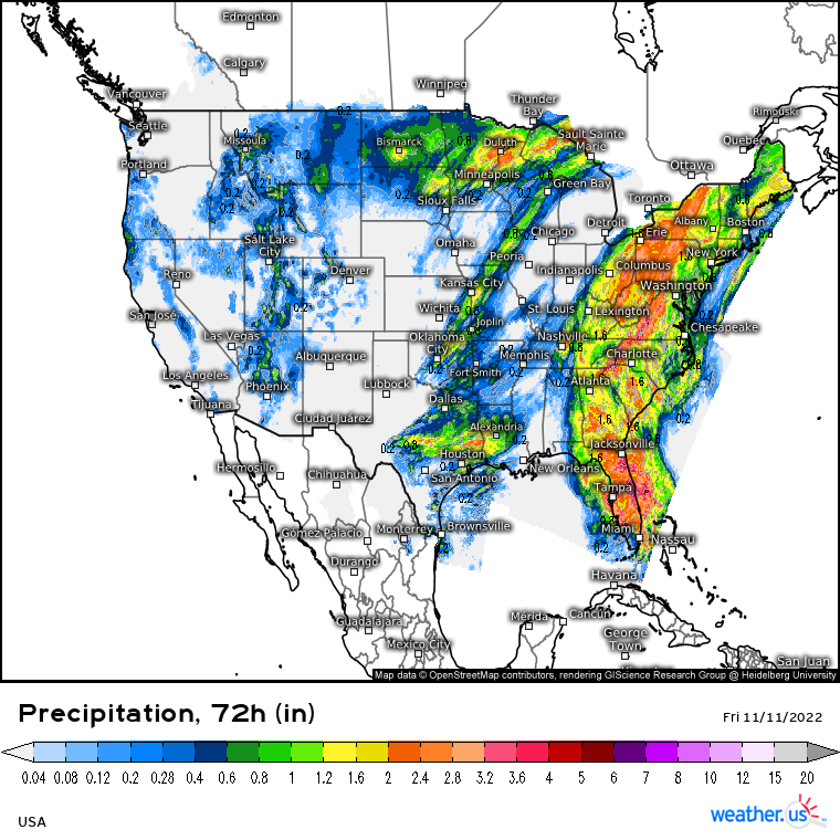
As Nicole made landfall on November 10 on North Hutchinson Island, FL, it brought with it that deep tropical moisture hurricanes are so well known for. Heavy rain alone is usually an issue for any location, but heavy rain on top of the flooding from Hurricane Ian 6 weeks earlier was disastrous.
Nicole quickly crossed the Florida peninsula and briefly emerged into the Gulf of Mexico before making another landfall the same day in the Big Bend region of Florida.
Nicole’s tropical moisture was then squeezed northward ahead of an incoming trough. Once again the Southeast and Mid-Atlantic were inundated and more flooding resulted.
Nicole was only the third hurricane in recorded history to make landfall in Florida in November. Despite it “only” being a category 1, this storm once again proved the point that hurricanes don’t have to be extremely strong to be extremely impactful.
November Lake Effect Snow
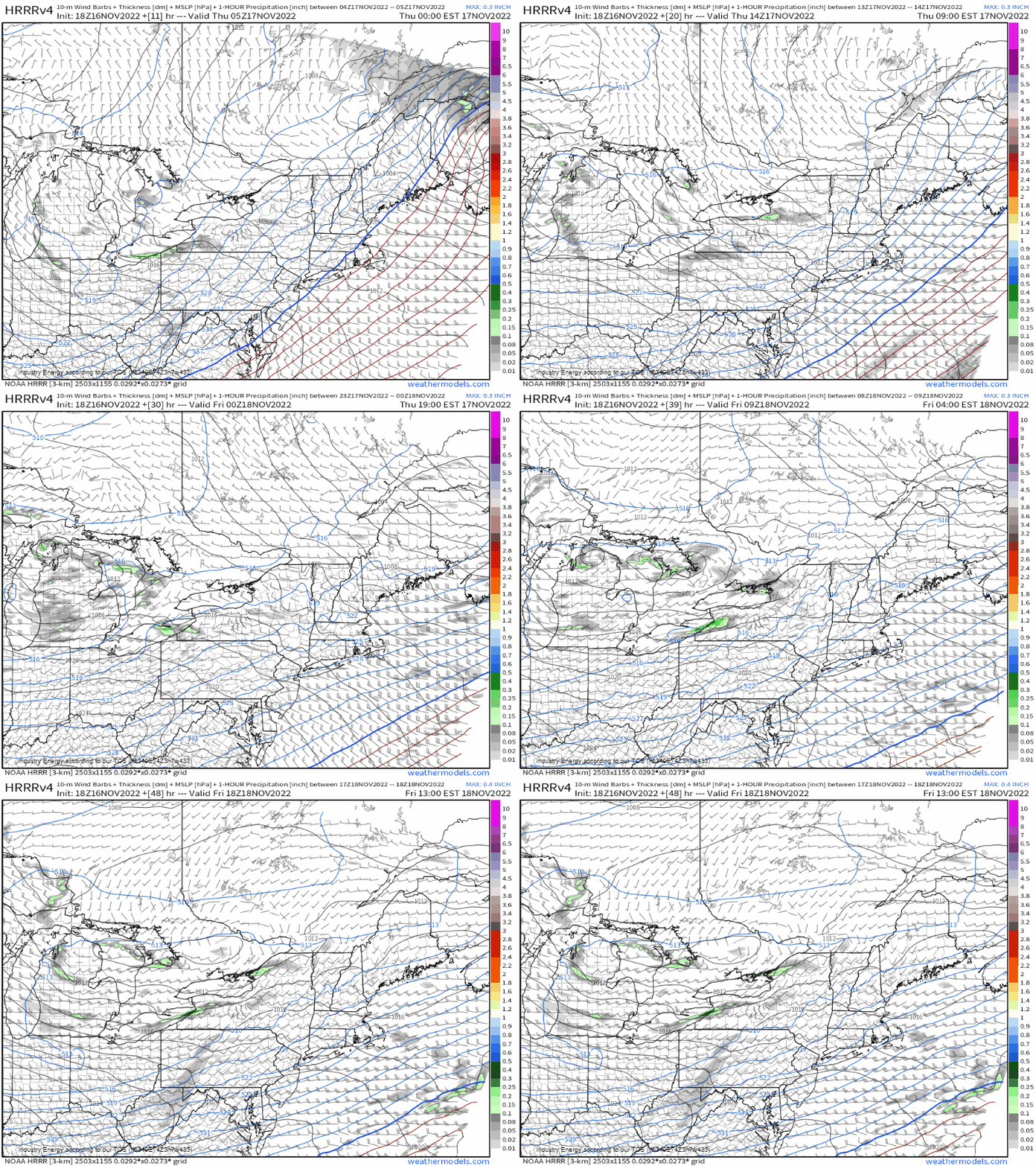
As hurricane season was breathing its last gasp, winter was beginning to nudge in to the northern reaches of the United States.
In mid-November, a trough pushed through the Northeast. One the back end was chilly air and a favorable set-up for a prolonged lake effect snow event off of Lakes Erie and Ontario.
South-southwesterly flow would materialize and linger as the trough lifted northeast, allowing winds to flow in a long fetch across a nearly record warm Lake Erie and still-rather-warm Lake Ontario.
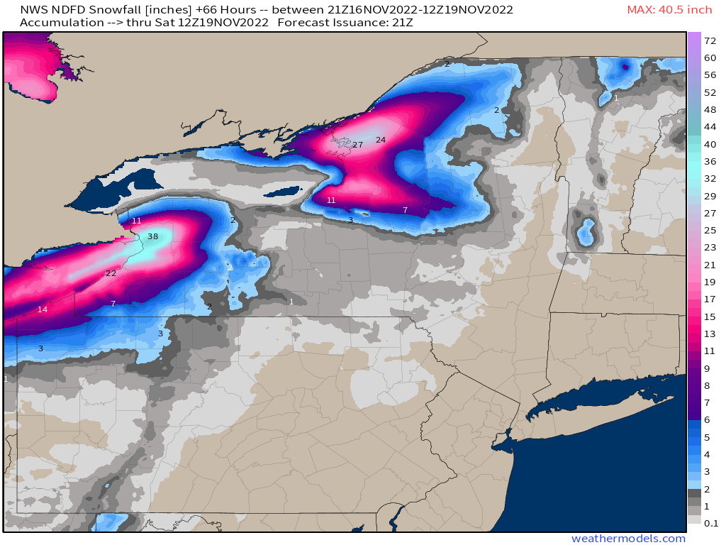
Models displayed some insane totals – nearly 4 feet near the Buffalo area! As it turns out, they weren’t insane enough.
Forecasted soundings ahead of the event displayed a nearly 19 C degree difference between the lake temperature and the 850 mb level. This pointed to plenty of low-level instability to power the event.

Late on November 17, a firehose of moisture began streaming off of the lakes. The most potent snow band of the event quickly set up just south of Buffalo, NY. Though it wiggled some from time to time, it blasted towns just south of Buffalo through the morning of November 19.
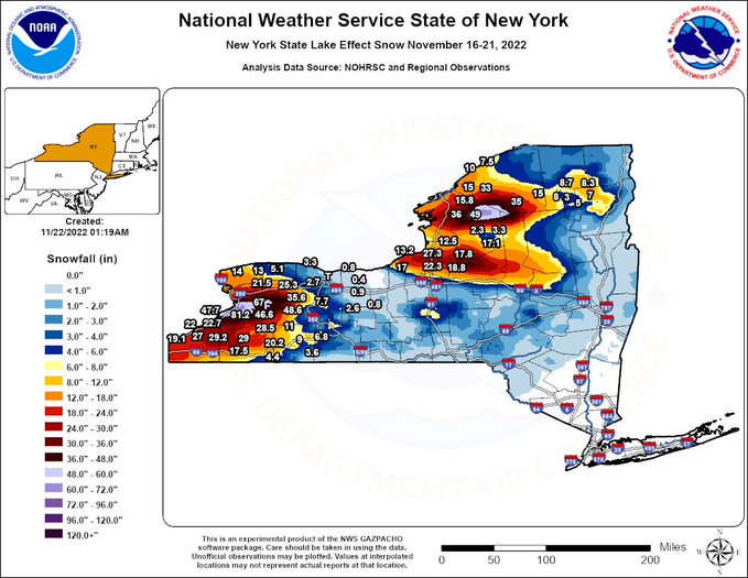
When all was said and done, an incredible 81.2 inches was recorded at Hamburg, NY while the nearby Orchard Park, NY measured 80.0 inches. There were other impressive totals from around the Great Lakes, but these were simply mind-blowing.
Unfortunately for this region, this wouldn’t be the last “mind-blowing” lake effect event of the season.
Arctic Outbreak of December 2022
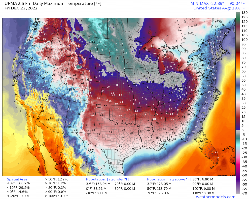
Though November 2022 produced a few interesting severe weather set-ups, we’ll keep with the theme of winter weather and move on to the Arctic Outbreak that occurred just a week ago.
Keep in mind that any data from this event is still being sorted through and stats are preliminary at the time this blog is being published.
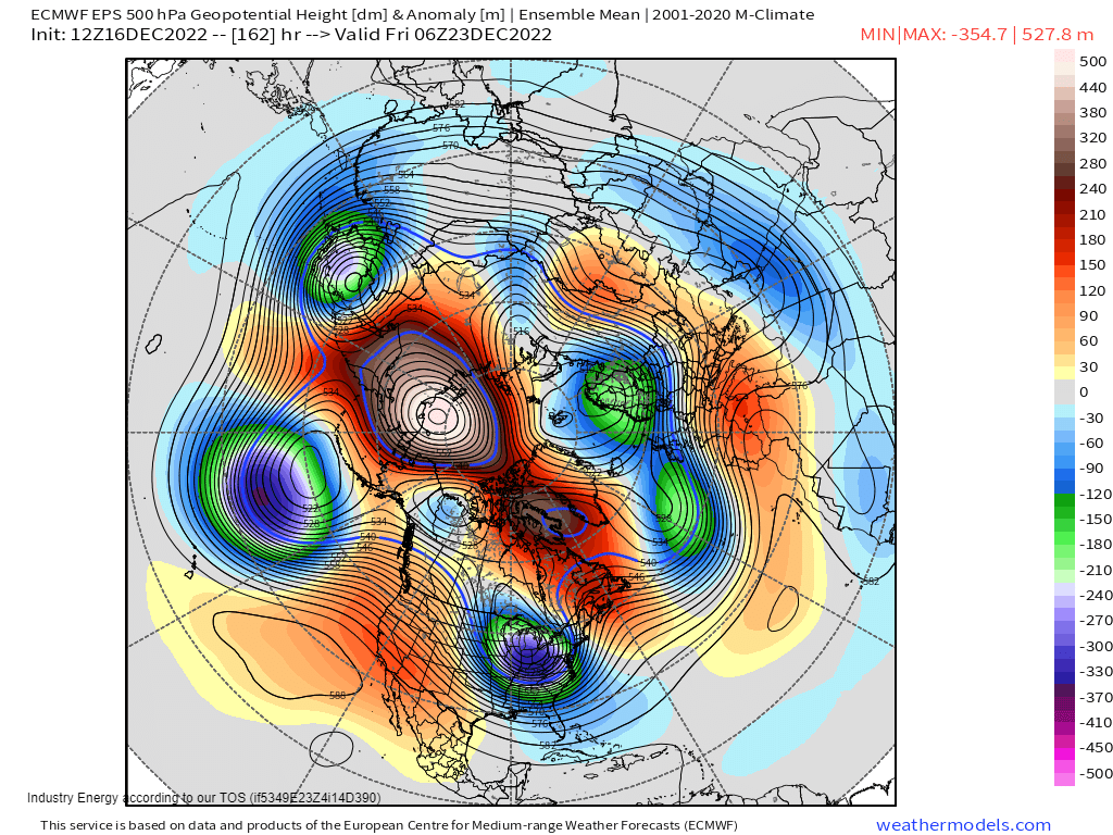
Toward the end of November/beginning of December, meteorologists began to notice teleconnections lining up in the forecast in a favorable way to produce anomalously cold air for those east of the Rockies.
After a bit of a delay due to a stubbornly negative PNA, the switch finally flipped. A -AO, west-based -NAO, -EPO, and +PNA lined up, providing us with cross-polar flow. The Siberian Express spilled into Canada and then finally into the lower 48.

Temperatures plummeted. Daytime highs as low as -20 F were seen in the Northern High Plains. Single digits passed for high temperatures as far south as the Tennessee Valley.
Many recorded their coldest Christmas in decades. Additionally, many traditionally warmer locations spend over 100 hours below freezing. Rolling blackouts were common in the south as the power grid struggled to keep up with the much-increased demand for heat.
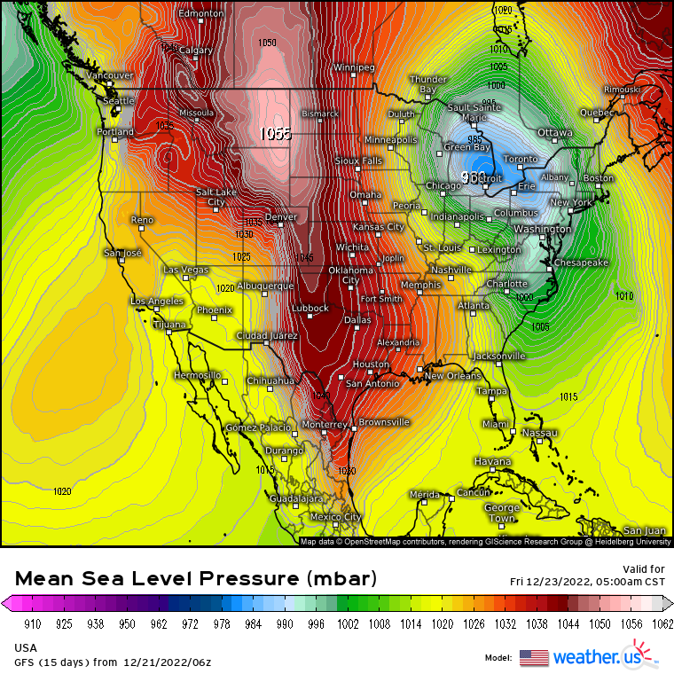
Ahead of this arctic air, a mid-latitude cyclone plowed northeast, bombing out as it went. The resulting pressure gradient from the deep low and a strong high on either side lead to sometimes-intense, long-lasting winds over a large area.
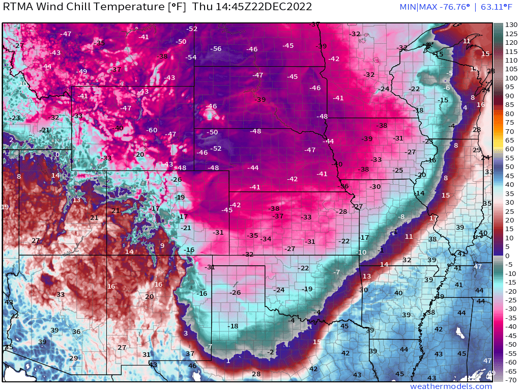
Wind chills as low as -70 F were recorded in the Northern High Plains. Additionally, wind chills below zero were felt nearly to the Gulf Coast.
Winds facilitated blizzard conditions throughout the Midwest and, later, into the Northeast as a long-duration lake effect snow event began as the bomb cyclone departed.
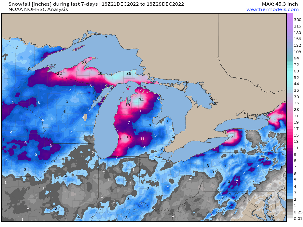
Heavy snowfall and serious blizzard conditions lasted for days, especially for Buffalo, NY.
Unfortunately, there were more than a few casualties attributed to this event. At the time of publication, at least 31 people had died in Erie County, NY alone as a direct result of this storm. Some were victims of the elements. Some saw their health fail while trying to clear snow.
Though we’re still sorting through all the data from this event, it is clear that the Bomb Cyclone/Arctic Outbreak of 2022 will be remembered for a very long time.
That just about wraps up my portion of the Most Memorable Events of 2022. Check out Part 2, written by Armando and available on December 30th, for the rest of this year’s weather story.
***All stats sourced from NWS, WPC, and SPC official reports.

