More Severe Storms And Flash Flooding In NE TX/AR Today As Future East Coast Storm Develops
Hello everyone!
Today will feature yet another round of severe weather and flash flooding in the NE Texas/Southern Arkansas area as another storm system develops over the Southern Plains. This storm is headed more towards the east than north however, which means it won’t be as strong as the last one, and thus both the flash flooding and the severe weather won’t be nearly as intense today as they were on Saturday. That doesn’t mean they won’t cause problems though! As this system moves to the east-northeast over the next couple days, it will bring some snow to parts of the Midwest before redeveloping off the East Coast into a powerful Nor’easter. Meanwhile on the West Coast, another powerful storm will bring copious amounts of rain and mountain snow to areas from Washington all the way down through much of California beginning tonight and extending through tomorrow and Friday. I will have more information on that storm in a separate blog post later this morning.
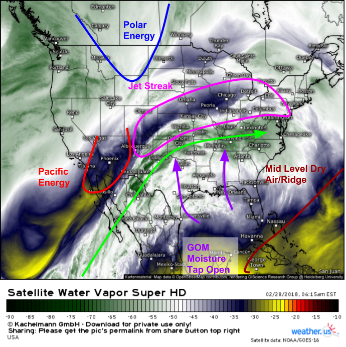
Here’s a look at GOES-East WV satellite imagery (what’s that?) this morning showing all the elements falling into place for today’s weather threats across parts of the Southern MS Valley. A deep plume of mid/upper level moisture is seen streaming across the region from the Tropical East Pacific, while the large mid level high that once reigned over the Gulf of Mexico has been kicked well east over the Tropical Atlantic. As a result, the Gulf of Mexico’s moisture tap is now open for business in the low levels. We can already see the results of this progress by looking at current observations in Texas where dew point temperatures are in the upper 60’s across the entire eastern part of the state as of 6 AM CST.
Additionally, upper level energy is approaching the region from the west as the upper level low that brought rain and snow to California earlier in the week moves east. This, along with the dynamics associated with the right entrance region of a strong jet streak over the Central US, will help set the scene favorably for upward motion capable of severe storms and heavy rain.
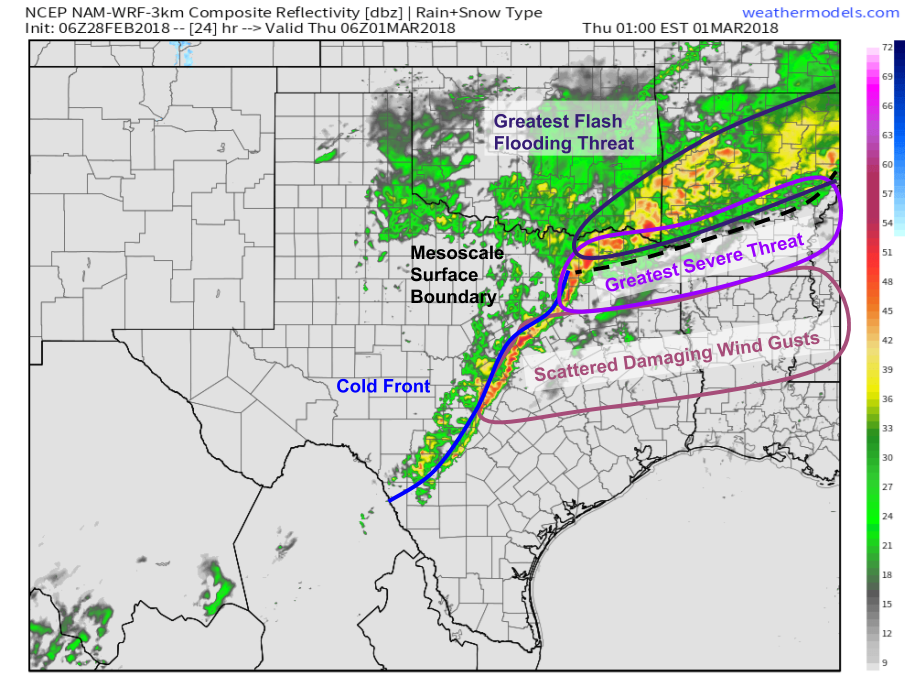
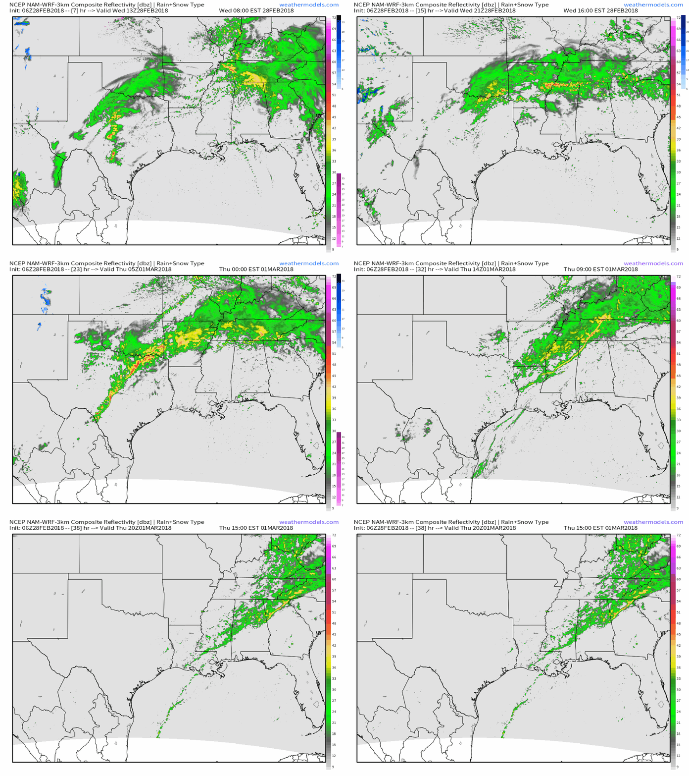
Here’s a look at what’s expected to happen as all that moisture interacts with some surface features underneath the background lifting provided by the upper level features discussed above. The NAM’s simulated radar map from weathermodels.com valid at midnight CST shows a line of storms along a cold front in Central Texas, as well as stronger but more disorganized storms along and north of a mesoscale boundary over far NE TX and Southern AR. It’s where the cold front intersects this boundary that the severe weather threat will be greatest. The main threats will be damaging wind and large hail, though a tornado or two can’t be ruled out. Farther south, a thin squall line is expected to form along the cold front which would favor a scattered damaging wind threat for parts of Eastern TX and Northern LA. Steadier and heavier rains are expected north of that boundary in Arkansas, and this is where the greatest risk of flash flooding will reside tonight before heavy rains move east early tomorrow morning.
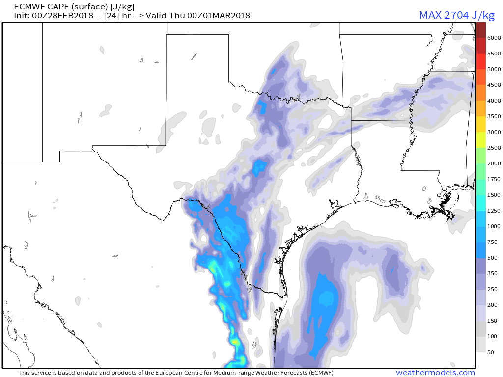
While forcing mechanisms and upper level wind patterns are very favorable for severe storms today, a widespread intense severe weather outbreak is not expected. This CAPE (thunderstorm fuel) map from the ECMWF via weathermodels.com shows why. Fuel for thunderstorms will be limited as persistent cloud cover in this area today will prevent the sun from drastically heating the boundary layer, which would result in a steeper vertical temperature gradient and thus more fuel for storms. Because of this limitation, any severe weather will be limited in scope, though it only takes one strong cell over your house to turn a marginal event into a very meaningful one.
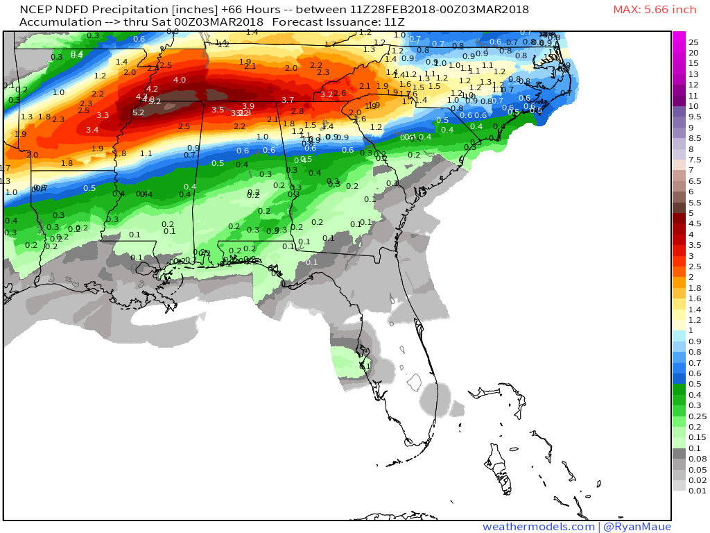
Here’s a look at the total rainfall expected from this system over the next couple of days. Notice the long axis of 3-6″ rainfall extending from Arkansas eastward into parts of the Southeast. Anywhere in that 3-6″ band is at a fairly high risk for flash flooding as storm cells train repeatedly over the same areas due to winds aloft (that steer storms) blowing parallel to the boundary that is located in this area. This, combined with a steady stream of moisture rich inflow from the Gulf of Mexico, will result in the flash flooding threat. Keep in mind that many of the areas expecting heavy rain from this system have already seen over a foot of rain in the past week due to persistent storm activity, so soils are already saturated and rivers already near bankful. Remember to never drive through floodwaters, and always heed the advice of local officials regarding any evacuations that might become necessary.
Map via weathermodels.com.
Here’s an animated version of the NAM’s simulated radar map I showed above that highlights the overall evolution of storms in this area today. You can see both the training of storms from Arkansas eastward through Tennessee, as well as the strong to severe storms erupting in Texas this evening. For more maps and animations like this, head on over to weathermodels.com.
As this storm heads east tomorrow, it will spark the development of a powerful Nor’easter off the Mid Atlantic coast. I will break that storm down in a separate post this evening.
For more information on your local forecast: https://weather.us/
For more information on the local forecast for ME/NH: https://forecasterjack.com/2018/02/28/another-very-mild-day-today/
-Jack
