Moderate Snow To Impact Parts Of The Northeast Tonight And Tomorrow
Hello everyone!
The Arctic front we talked about on Sunday morning has evolved more or less as expected through this morning. Light snow has fallen across the Plains with higher amounts in the Midwest/Great Lakes area. The front is now bringing widespread wintry precip to the Deep South as it encounters a little bit of Gulf moisture. If you’re interested in this aspect of the storm, read back to that Sunday morning post for a breakdown of the setup, and watch it unfold on HD radar maps, Super HD satellite imagery, and current observations. This post will focus on the next phase of the storm, which will bring a moderate snow event to parts of the Northeast tonight and tomorrow.
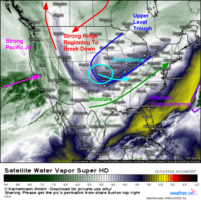
GOES East water vapor satellite imagery (what’s that?) shows all the pieces falling into place for a moderate snow event in the Northeast tonight/tomorrow. A strong ridge is located over the Rockies, stretching north into Western Canada. However, a strong Pacific jet is beginning to eat into this ridge, and its eventual collapse will play an important part in our storm’s evolution. If that Pacific jet wasn’t breaking down the ridge, this would likely be a major winter storm as opposed to a moderate event. Meanwhile, the specific disturbance that will be responsible for the developing storm is diving SE around the base of an upper level trough oriented SW-NE from Kansas to Michigan. This orientation, also known as “positively tilted” is forced by the collapsing ridge, which is oriented in the same direction. However, while this orientation is unfavorable for a major storm, a decent moisture plume is now becoming established from the Pacific as the jet begins to break down the ridge. Additionally, offshore thunderstorms are boosting downstream heights (more on that process, how it works, and why it’s important) near Bermuda, which will prevent the whole system from moving offshore too quickly.
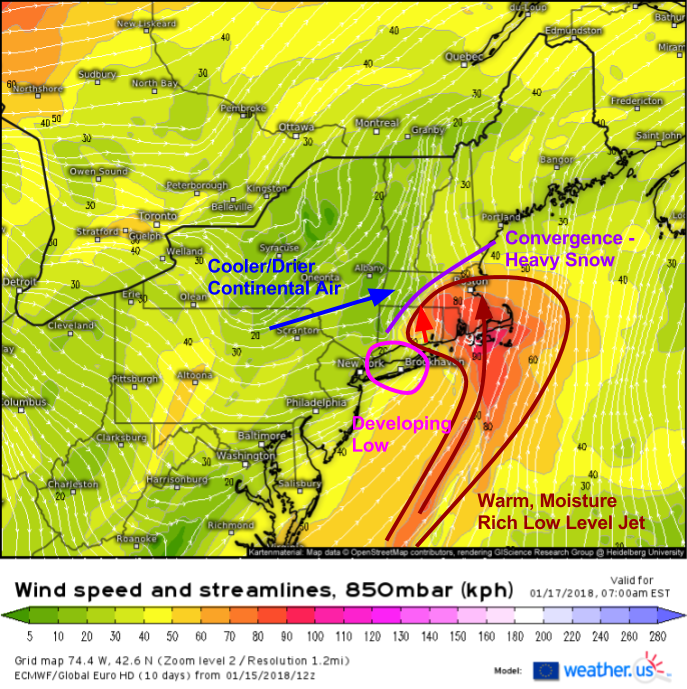
Here’s a quick look at the dynamics that will fuel a band of heavy snow tomorrow morning from NNJ up through coastal ME.
The most important dynamics at play will reside right around 5,000 feet, the level shown here. As low pressure begins to develop at this level over or just east of NYC, a process known as frontogenesis will occur to the north and northeast of the low. Frontogenesis is the process that results in the creation of a front. This process is important for the development of heavy snow bands, because it results in converging airstreams in the low/mid levels. Not only does this contribute to rising air that leads to precipitation, it also strengthens the thermal gradient due to the warm airmass coming in closer proximity to the colder airmass. As the low level jet runs into this increasingly strong gradient, it will promote an increasingly heavy band of snow. Because we’re dealing with frontogenesis on the front side of a weak storm system as opposed to the back side of an intense storm, there’s likely to be a single band of heavy snow that develops as a result of these dynamics. Confidence in the placement of that band is fairly high, but adjustments of a few miles in any direction will make a big difference for eventual snowfall totals.
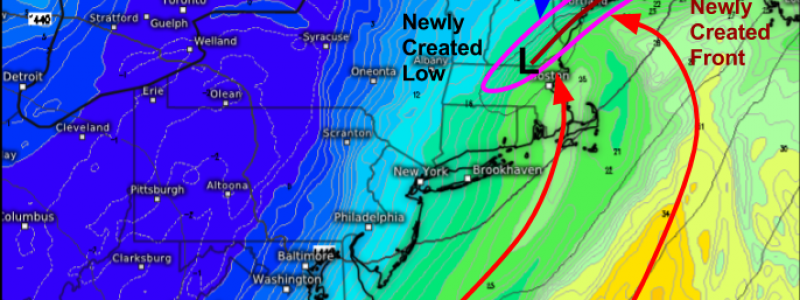
Here’s another way of visualizing the upcoming clash of airmasses and 850mb dynamics that will result in the band of heavy snow. This map is one we just added to weather.us, and shows 850mb theta-e (a measure of atmospheric heat/moisture content) as well as 850mb geopotential heights. We can see a closed gph contour over Southern NH, signaling the development of a new low pressure system. Ahead of that low, we can see the frontogenesis process wrapping up, with a well defined frontal structure beginning to emerge along the coast of Maine. As the low level jet continues to push warm, moisture laden air parcels towards this front, they will be forced to rise up the front, cooling and condensing as they go.
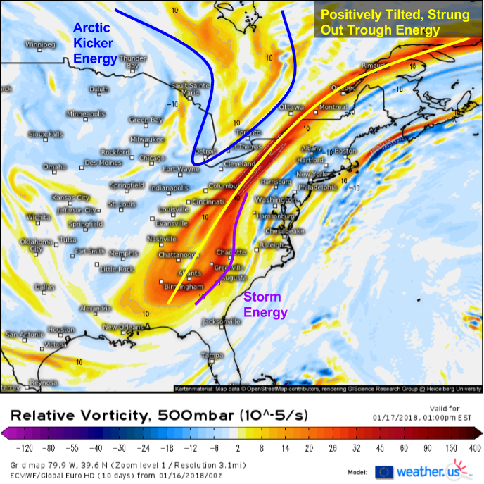
Here’s a look at the 500mb energy map, which shows why this storm won’t be a major one. Our main trough energy is strung out from Labrador to Alabama, and isn’t consolidated. It’s also positively tilted (NE-SW) meaning winds ahead of the trough axis are out of the WSW, which pushes any developing storm system ENE instead of NNE or N. There’s also the problem of an Arctic kicker disturbance that instead of dropping into the trough and amplifying it, will act to push the whole system offshore even more quickly than if it were left to its own devices. The energy pinwheeling around the base of the trough through the Southeast/Southern Mid Atlantic will be a little too late for our lower level systems, which will develop well NE of the upper level support. As a result, none of the dynamics here will be explosive, unlike the past couple systems on the East Coast, however a long enough period of moderate snow will produce some decent totals even without 2-3″/hour snowfall rates.
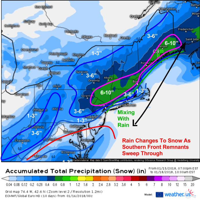
Here’s how much snow I’m expecting from this system. There are lots of complicated dynamics at play, but this map should work out pretty well. In areas under the frontogenesis band from NNJ through NW CT, much of MA, and into Coastal ME, over 6″ of snow can be expected, with a few isolated areas of 8-10″. As the dynamics of the coastal low itself take over, heavier snow bands will expand in coverage and intensity over parts of Downeast Maine. The front itself is bringing light-moderate snow to parts of the Appalachians/Ohio Valley this morning, and as that front sweeps east today, rain will change to snow in parts of Virginia with an inch or two of accumulation possible. Snow will wrap up tomorrow from SW to NE as the system moves into Canada.
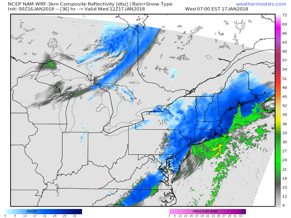
While storm total snowfall will be far from record setting, this simulated radar map from weathermodels.com shows moderate to heavy snow falling at 7 AM tomorrow from NYC to Boston. This will cause big problems for the commute, as moderate/heavy snow and the morning rush don’t work well together. Don’t be fooled by the low totals, especially in places like NYC and Boston where a brief period of rain could hold totals down a bit. 4″ may not sound like much, but if it’s falling right as everyone’s headed to work and school, major problems will ensue! Plan for delays and use extra caution if you do have to head out tomorrow morning.
Track this storm with the array of tools we have at weather.us, including HD radar imagery, Super HD satellite imagery, and current observations (click any map to zoom in for more detail, all the way to county level), as well as the model data both at weather.us and weathermodels.com.
-Jack



Nice write up Jack .. well done.
Thank you Roger!