Michael Rapidly Intensifying As It Moves Into The Gulf Of Mexico
Hello everyone!
Michael is rapidly intensifying between the Yucatan Peninsula and Cuba this morning, and has earned hurricane status as of the 11 AM EDT advisory from the National Hurricane Center. The storm will continue to move generally north over the next couple days, before making landfall in the Florida Panhandle Wednesday night or Thursday morning. With favorable conditions ahead for the storm, intensification into a major hurricane is possible. This blog entry will be a longer, more in-depth look at Michael, its impacts, and some of the dynamics associated with the storm.
As an additional note, if you’re confused about any of the maps here, I’ve included links to tutorials I’ve done on many of our products. You can find them below the maps under the “Tutorial” headings. If you’re confused about something without a tutorial heading, drop a note in the comments section or send me an email jack@weather.us and I’ll add it to the list.
Beginning this afternoon, I’ll have a “live blog” with short updates posted every few hours on the latest trends with the storm. Dr. Ryan Maue is also running a live blog, which you can find here. In addition to these blogs, you can find our updates on Twitter @WeatherdotUS, @RyanMaue, and @JackSillin. Also be sure to remain informed with official info from the NHC and local NWS offices.
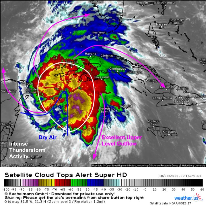
Here’s a look at Michael this morning, showing what’s overall a fairly healthy system. Upper level outflow is excellent, and fans out in all directions which indicates a general lack of wind shear. Very cold cloud tops below -70C are noted throughout the storm, with numerous “hot towers” or extremely intense thunderstorm cells below -80C. The only fly in the ointment appears to be some dry air sneaking into the storm’s southern flank. While this may temporarily slow strengthening a little bit, it’s not expected to have a long term impact on the storm’s structure or intensity.
Tutorial: Satellite imagery
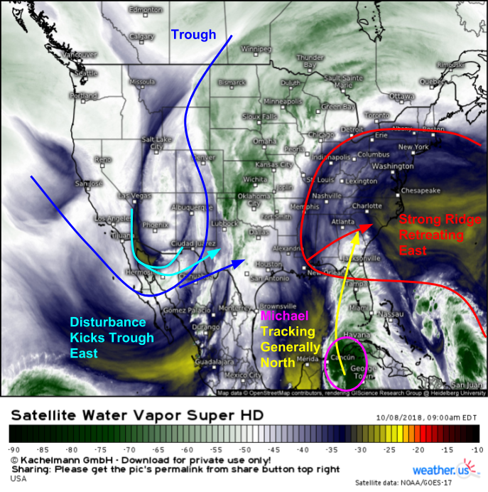
The steering pattern for Michael visible on WV satellite imagery is fairly straightforward, and is resulting in high confidence regarding the track forecast. A strong ridge is noted over Bermuda, with a strong trough centered over the Four Corners region. Michael will be tracking north through the gap between the two. While this gap is currently centered over Texas, a strong disturbance digging into NW Mexico will kick both trough and ridge east so that gap is located over the Florida Panhandle by Wednesday, which will lead Michael to make landfall somewhere near Panama City. Of course the exact point of landfall is still subject to adjustment, but the range of possible outcomes is fairly narrow at this point.
Tutorial: Satellite imagery
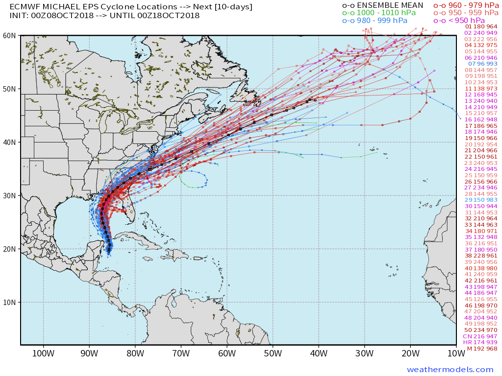
EPS track guidance further highlights the fairly narrow range in possible outcomes. Notice the vast majority of members (49/51) take Michael through the Big Bend region of Florida before moving NE through Georgia and the Carolinas then out to sea. The two members that take the storm near Tampa are strong outliers and should be discounted as there’s no support for that solution in observational data. Notice also that there’s strong consensus in the storm strengthening as it approaches landfall, with nearly all members dropping the storm’s central pressure dramatically over the next couple days. Map via weathermodels.com.
Tutorial: Storm track ensembles
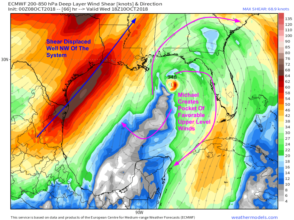
Environmental conditions support this strengthening. While I had concerns on Saturday about wind shear and it hampering Michael’s ability to strengthen, newer forecast updates show Michael carving out a pocket of favorable upper level winds by way of its intense thunderstorm activity. These thunderstorms create upper level high pressure above the storm, which acts to “deflect” wind shear away to the northwest, if the storm is strong enough. This is exactly what’s forecast for Michael, and shear is not expected to be much of a concern as the storm moves north. Map via weathermodels.com.
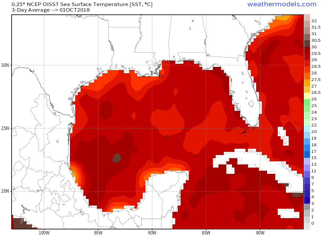
Wind shear isn’t the only thing needed for intensification of a tropical cyclone. Warm ocean temps are also crucially important. Unfortunately for residents of the Florida Panhandle, the Gulf of Mexico is far from chilly this time of year. Tropical cyclones typically need Sea Surface Temps (SST’s) above 26C to sustain themselves. Current readings along Michael’s forecast path range from 29-29.5C. Map via weathermodels.com.
Now that we have a good idea of some of the meteorological dynamics associated with Michael and its forecast for the next few days, we can take a look at some impacts.
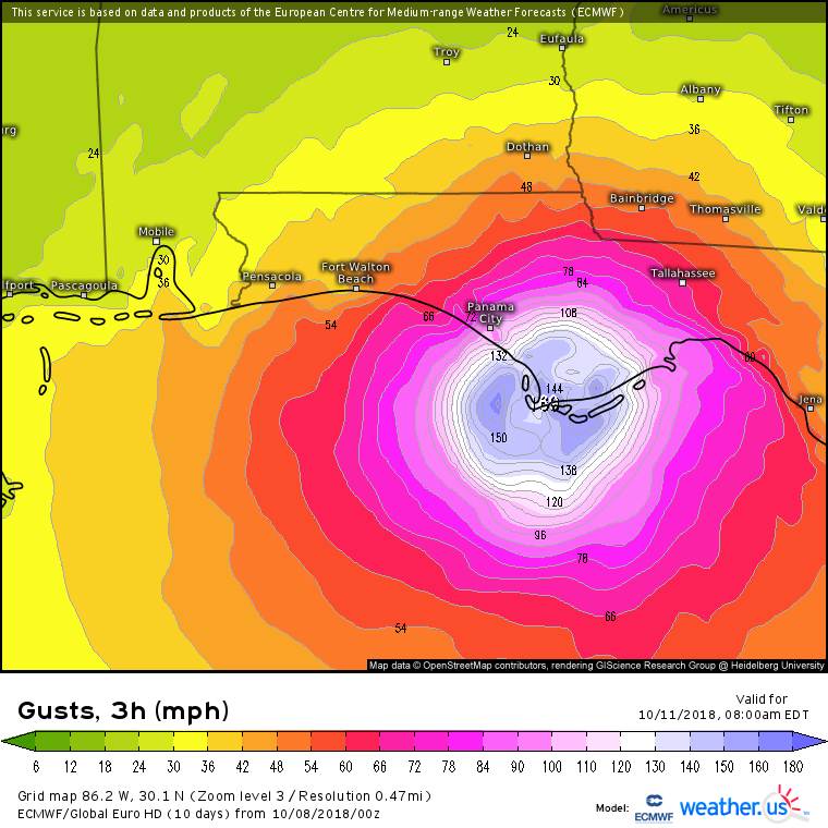
Of course, with a major hurricane landfall comes the threat for very strong winds. This is the ECMWF’s idea for wind gusts at landfall Wednesday/Wednesday night. Don’t focus too much on the exact numbers, but any of the white/blue areas near the Apalachicola National Forest should be prepared for destructive wind gusts above 120 mph. Strong damaging winds over 70 mph will extend farther from the core, and will likely impact the metropolitan areas of Panama City and Tallahassee.
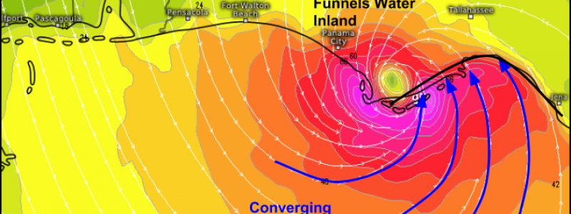
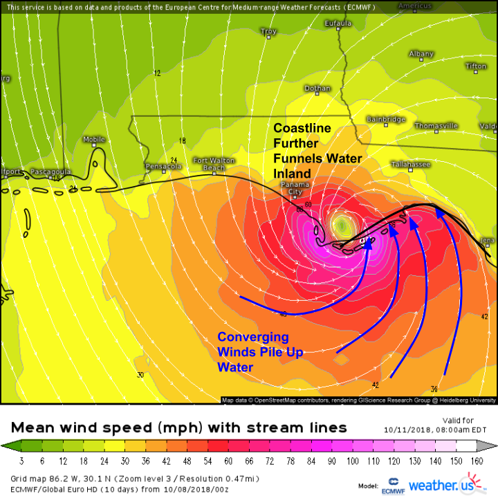
The wind speeds will be important for wind damage, but for storm surge, it’s all about wind direction. Unfortunately, due to the shape of the coastline, and the topography of the area, the coastline south of Tallahassee is extremely vulnerable to storm surge. Winds will be converging on this area as the core of the hurricane moves ashore to the west, and this converging wind pattern will push water up against the coast. This effect will be further enhanced by the shape of the coastline, which will also help funnel water inland. As a result, coastal areas south of Tallahassee should be prepared for extremely dangerous storm surge flooding. Heed the advice of local officials if they tell you to evacuate!
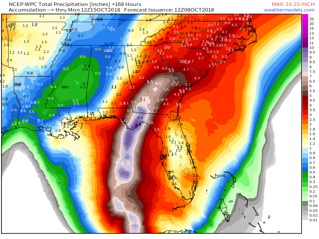
Our final big impact to discuss will be rain. Tropical cyclones always produce a lot of rain, and Michael will be no different. Locations near the path of the storm’s core can expect a good 7-10″ of rain this week. Thankfully, Michael will not behave like Florence in the sense that it will be moving briskly during and after landfall. There won’t be any lingering or days of persistent downpours. The bad news is that after making landfall in Florida, Michael will turn to the northeast, and bring tropical storm conditions to the Carolinas. This will include another 3-6″ of rain that areas still waterlogged after Florence certainly do not need. Map via weathermodels.com.
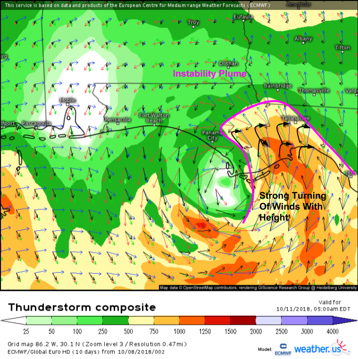
Finally, in addition to the wind/rain/surge, we’ll have to worry about tornadoes in the storm’s northeast quadrant. The ECMWF’s thunderstorm composite map shows a plume of instability in this region of the storm, with very strong turning of the winds with height. Given the strength of these winds, there will be an enormous amount of rotational energy available for thunderstorms to tap into. This threat will be maximized near/before the time of landfall, and will extend inland to parts of far SW GA.
Tutorial: Thunderstorm Composite
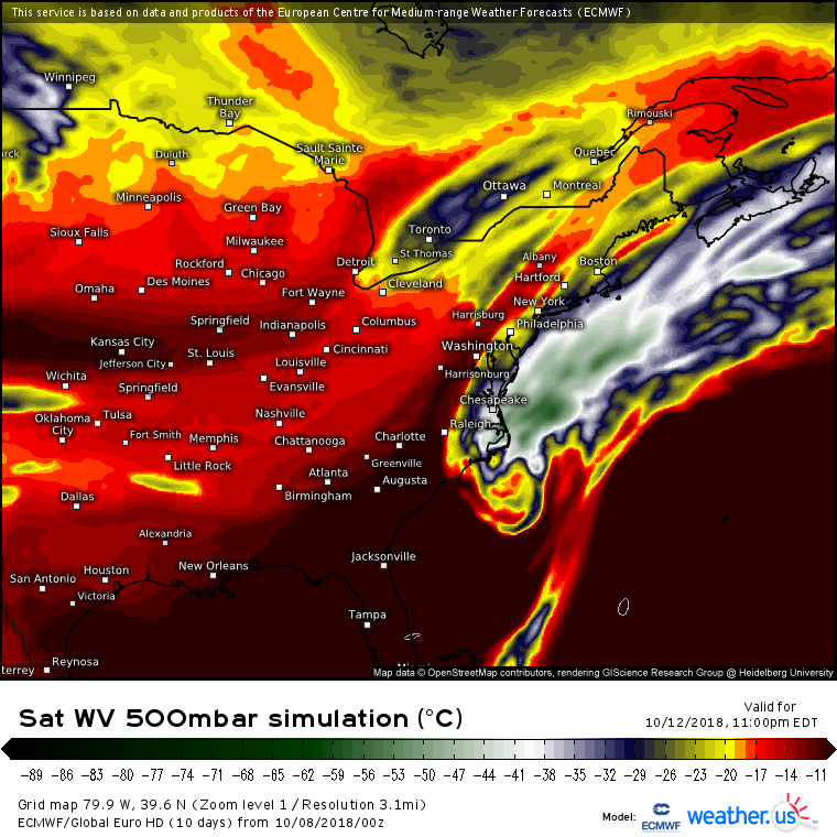
Michael will depart the US as a strong extratropical storm on Friday.
Keep tabs on Michael with all the tools we have at weather.us including HD satellite imagery, model data, town-specific forecast data, HD radar imagery, and lightning analysis.
I will start my live blog later this afternoon/evening with shorter and more frequent updates. Ryan’s live blog can be found/followed at this link. Official NHC forecasts can be found here, and official local NWS forecasts here. Be sure to stay updated with official info first, and use our thoughts as supplemental info. We’re not here to replace NWS/NHC!
-Jack


You are absolutely brilliant. I searched every site until FINALLY I found someone to explain every question I had. Thank you so much for your hard work and apparent understanding of the weather. I live in Mobile, AL. We are used to tropical events and and barely flinch at the sight of a storm to be honest unless its a strong cat 2 or more.. even then we are leary of weather reports. My city in particular has not had a direct hit from a major hurricane since 1979 believe it or not; Hurricane Frederick. I was only 7 years old. I have never seen another one like it. Katrina and Ivan were so-so in my city as we did not take a direct hit. We have been blessed as the storms pass by us like we have an invisible force-field or hurricane repellent or something. I really enjoyed your explanation and it was very easy to follow. I am adding you to my favorites. Lastly, are there any other links you have? I would like to read your posts more often.