Messy Winter Storm To Impact The Midwest And Northeast Tuesday Into Wednesday
Hello everyone!
Our next winter storm will be another of the ‘messy’ variety with precip falling as a mix of rain, sleet, freezing rain, and snow for a large swath of the Midwest and Northeast over the next few days. While freezing rain won’t accumulate enough to cause widespread power outages, ice will be a fairly major part of the story as warm air has a much easier time moving in aloft than at the surface. This post as always will be a mix of what to expect from this system, and some of the meteorology that explains the forecast.
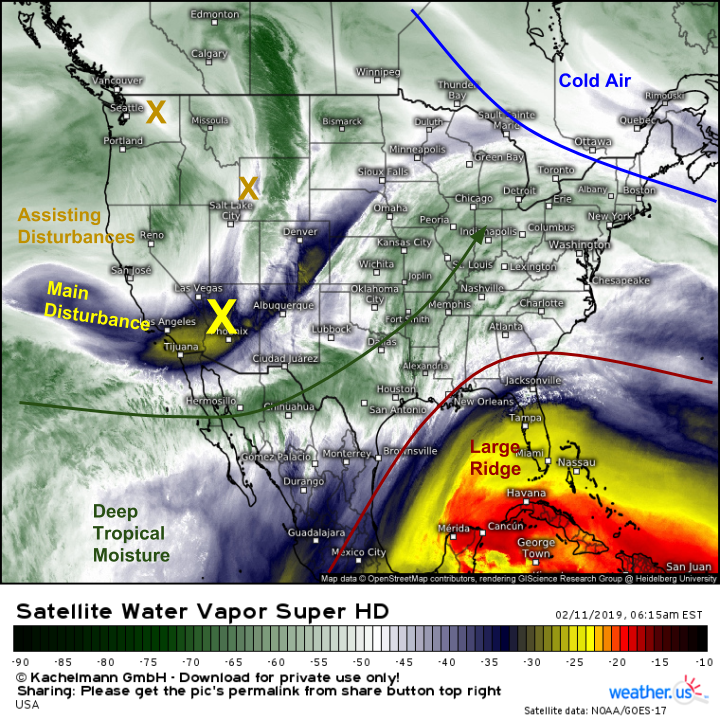
Here’s a look at GOES-East WV satellite imagery this morning, showing the large scale systems that will work to create the messy storm in the East. The first feature to note is the large ridge over Florida. This will act to redirect upper level energy and moisture north towards the Great Lakes instead of east out to sea. As far as moisture and upper level energy go, we have plenty of both. Deep tropical moisture from the Pacific can be seen streaming into the Mississippi Valley ahead of several disturbances currently bringing snow to the Rockies. This moisture and energy will be running into cold air establishing itself over SE Canada and New England, setting up the wide variety of precipitation types.
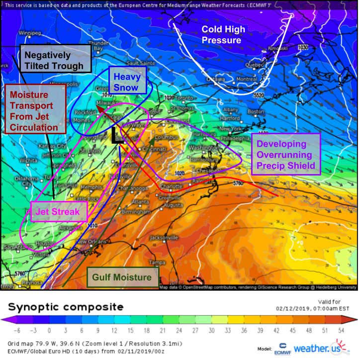
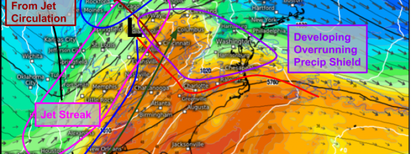
The first phase of the storm will begin tonight/tomorrow morning across the Midwest, and the ECMWF’s synoptic composite map does a great job highlighting the dynamics involved. Low pressure will develop in the Plains and move towards the Ohio Valley as the upper level energy we saw on WV imagery above moves out of the Rockies. A seasonably strong jet streak will extend from Texas up towards Ontario, with the exit region of the jet over the Great Lakes. In the exit region of jet streaks, air moves from the warm side of the jet towards the cold side in the low to mid levels (below the upper level jet core) as part of what’s known as an “indirect thermal circulation”. That circulation will draw moisture from the Ohio Valley back to the west into a colder airmass. The left exit region of the jet streak will provide upward motion, and the result will be bands of moderate to heavy snow.
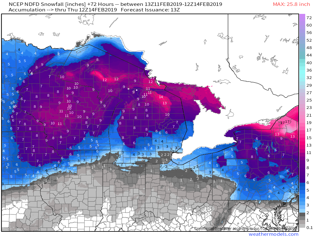
Here’s a look at the National Weather Service’s forecast for snow totals in the Great Lakes. Most of Wisconsin and northern Michigan can expect 6-12″ of snow, with lesser amounts to the NW (farther away from the circulation that is bringing in the moisture) and SE (too warm for all snow). Snow will develop in the Midwest this evening, peaking in intensity tomorrow morning, then tapering off tomorrow evening as the second phase begins in the Northeast. Map via weathermodels.com.
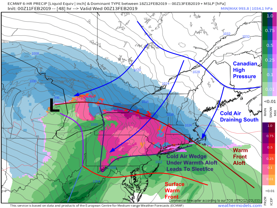
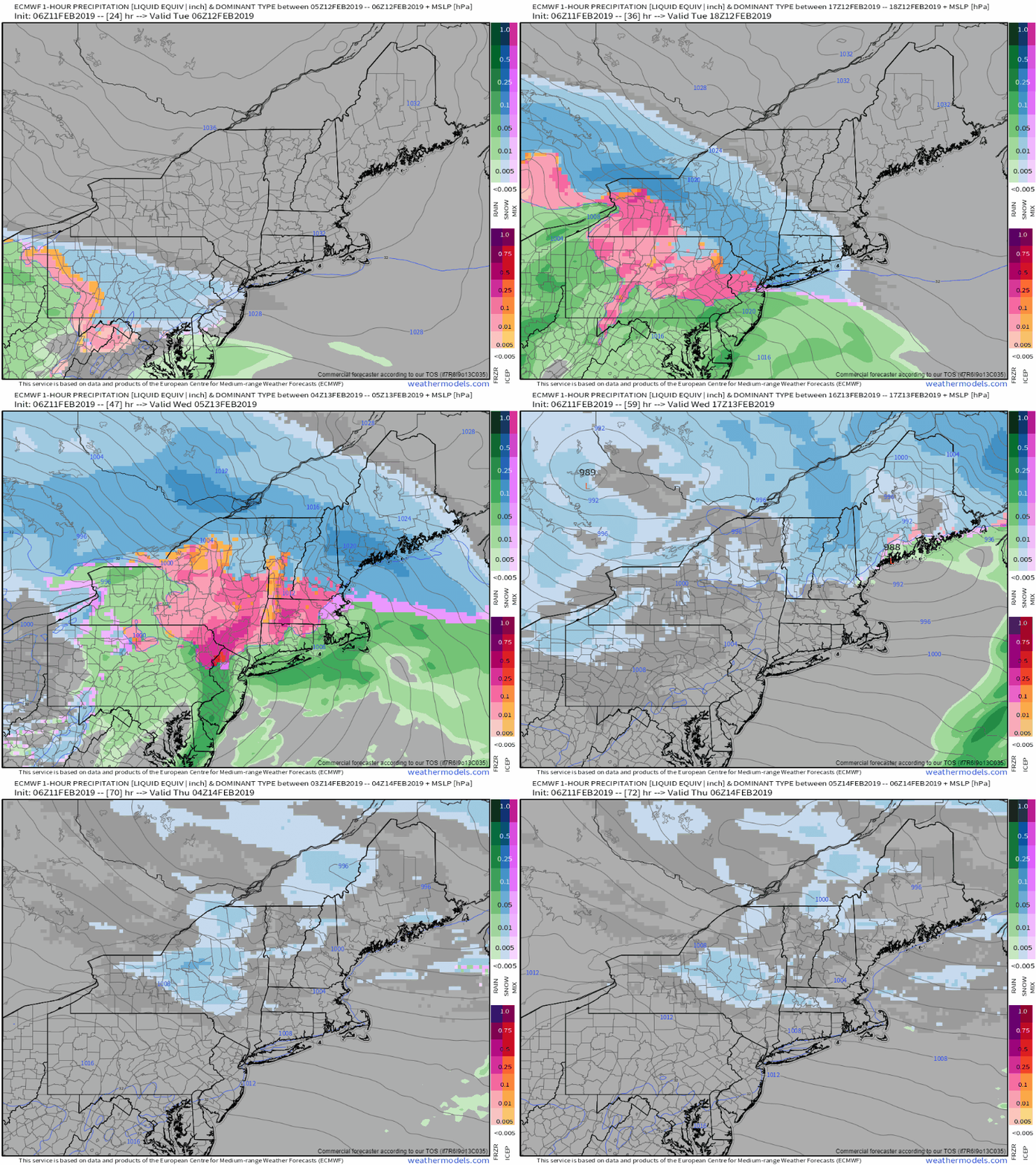
Phase two of the system will be a trickier forecast as our full range of precipitation types become involved. The ECMWF’s precipitation type forecast shows this issue fairly well. Most precipitation will be associated with the cyclone’s warm front, as warm air from the Pacific is forced to rise up and over low level cold air provided by Arctic high pressure in Canada. This is a fairly common process, but in this case the warm front at 10,000 feet will be several hundred miles north of the surface front. In between, we’ll see a large area where temps aloft are too warm for snow, but surface temps are still below freezing. The result will be plenty of sleet and freezing rain, along with all the hazards of ice on roads, trees, and power lines. Map via weathermodels.com.
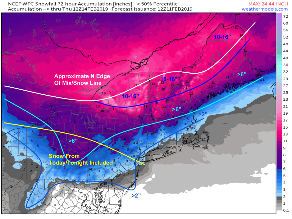
So how much snow will actually accumulate? Here’s a rough outline. A frontal boundary draped over the Mid Atlantic has been bring continued light snow and sleet to PA/MD/WV over the past 12 hours or so, and will continue through the day today. Because that snow is a separate system, I won’t dig into it too much but you can track it yourself with HD radar, and a look at the ECMWF’s synoptic composite maps for this morning should give a pretty good sense of the dynamics behind it if you’re curious. Map via weathermodels.com.
The main event will produce a widespread 4-8″ snowfall from central/western NY all the way up through northern New England. Lighter amounts will be found to the southeast where mixing with sleet/rain will occur sooner. The mountains of N NY, N VT, and NW ME will hold onto snow the longest, and may escape with very little in the way of sleet. That’s where you’ll find the best shot at seeing over a foot of snow out of this system.
Here’s a rough outline of how precip types are expected to evolve over the course of the storm tomorrow. Everyone north of the Mason Dixon line will start out with at least a few flakes. The coast will then see a change over to plain rain, while inland areas see mixed precipitation including both sleet and freezing rain. A cold front will move through the area on Wednesday, bringing snow back to northwestern areas primarily in the form of lake effect. GIF via weathermodels.com.
-Jack
