Making Sense Of Model Forecasts For Tropical Storm Laura
Hello everyone!
Much attention is being paid to weather model forecasts of Tropical Storm Laura this afternoon as the system looks to threaten the US Gulf Coast as a hurricane this coming week. There are so many models out there that you can find almost any solution you want if you just look through enough guidance. This afternoon’s suite of guidance is a stellar example of this idea. Looking for a model that shows extreme rapid intensification of Laura into a Category 5 hurricane? The HWRF has you covered. Looking for a model that shows Laura struggling to become more than a mid-grade tropical storm? Head on over to the ECMWF. So does this mean we’re left with no idea of what Laura will do? Thankfully no. Through careful analysis of available model guidance and observations of what the atmosphere is actually doing, we can extract lots of useful information even from seemingly chaotic model runs. This post will walk interested readers through that process. If you’re interested in the key takeaways from a forecast perspective, skip to the end of this post or re-read this morning’s update.
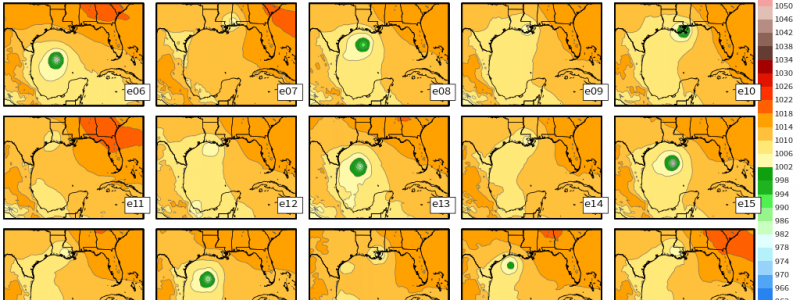
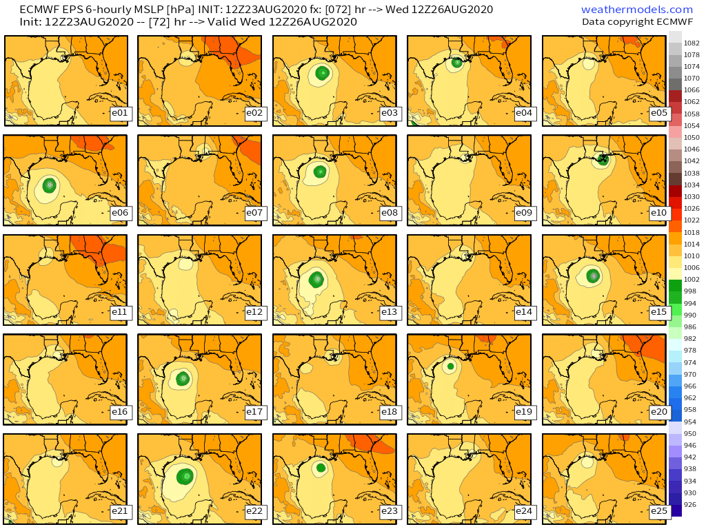 Our central problem when looking at model guidance (especially this afternoon it seems) is that they depict a wide range of possible outcomes for Laura and at face-value, it can seem hard to figure out which solutions are more or less likely to verify. To illustrate this, the image above shows 25 ECMWF ensemble member sea level pressure forecasts for Wednesday morning. If you were only to look at this (the end solution), would you be able to make an educated guess about whether member 22 (showing a major hurricane) or member 24 (showing a weak tropical storm) was more likely?
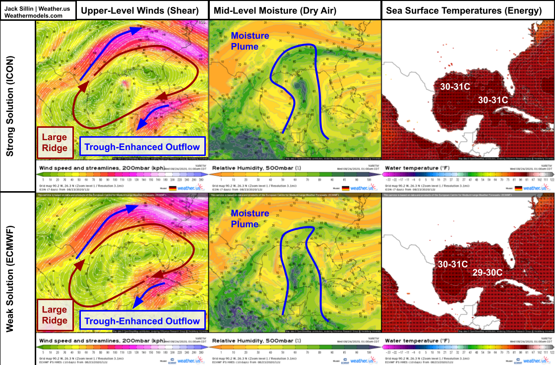
Thankfully, there’s a lot more information still on the table here. The first natural question to ask is something along the lines of “why do certain model forecasts show extreme intensification while others show a much weaker storm”? Remember that there are a few important variables working to determine how strong Laura will get. Variables contributing to Laura’s intensity can be broken down into one of two categories: its environment and its structure. So lets compare depictions of some of those relevant variables between a model showing an intense hurricane and a model showing a weak tropical storm.
On the environment side, there is essentially no difference between the models. Both the “strong” and “weak” models show an environment over the Gulf of Mexico that is just about off-the-charts favorable for rapid intensification. There’s a huge ridge aloft with trough-enhanced outflow channels both to the north and south of Laura’s center. The system is embedded within a deep plume of moisture so dry-ish air to the west and northeast of the system will be kept separate from the core. The ECMWF does show slightly cooler SSTs over the eastern Gulf of Mexico because its oceanic model is coupled to its atmospheric model so its correctly identifying a tiny bit of upwelling/overturning due to Hurricane Marco. However I assure you that Laura will have absolutely no problem intensifying over 29C waters. All that to say that the variability in model intensity forecasts is not attributable to variability in forecasts of environmental parameters. Even the models showing a weak storm show a very favorable environment for intensification.
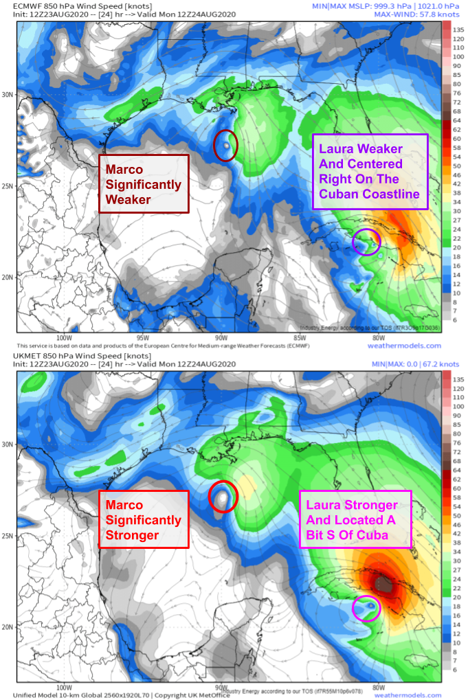 That means that different models are showing different possible outcomes for Laura based on differences in depicting its structure over the Gulf of Mexico. The ECMWF is showing a broad and disorganized system that doesn’t have enough time over water to organize an inner core, and other guidance such as the ICON, GFS, and UKMET are showing a compact, intense system that is able to intensify over the Gulf. So what explains these differences?
There are a two primary variables to keep track of on the “storm structure” side of the equation: storm structure entering the GOM (controlled by Cuba interaction) and time spent over the Gulf of Mexico. A third variable could be called “random convective interactions” and is essentially impossible to predict with our current suite of weather models.
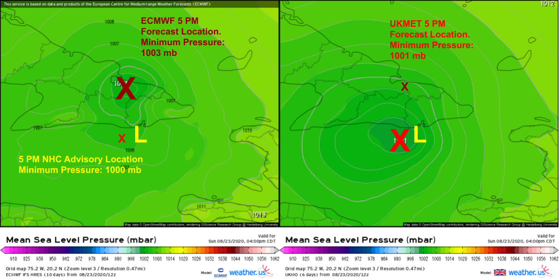
To investigate the first variable (initial structure heading into the GOM), we’ll compare the 24-hour forecast from the ECMWF (which, remember, is showing a weaker Laura) with the 24-hour forecast from the UKMET (which is showing a stronger Laura). A couple differences immediately pop out: the ECMWF shows a weaker system (peak 850mb winds ~55kts) located right on or just north of the southern coast of Cuba.
The UKMET shows a stronger system (peak 850mb winds ~65kts) located about 50 miles south of the southern coast of Cuba. So not only is the UKMET’s version of Laura stronger, it’s also positioned over warm water which would promote further strengthening before arriving in the Gulf of Mexico. Additionally, the UKMET solution would preserve the system’s existing inner core which would make subsequent strengthening easier.
So the bottom line on the “storm structure” side of the equation is that the stronger and farther SW Laura tracks over the next 24 hours, the more intense it could be in the Gulf of Mexico.
One additional item to note is that the UKMET and ECMWF disagree significantly on how strong Marco will be tomorrow morning. The ECMWF shows the system pretty much evaporating by then, with a barely-closed circulation south of Louisiana. The UKMET on the other hand keeps Marco a fairly intact system all the way to the Louisiana coastline.
Though this seems unrelated to the forecast for Laura, perhaps it won’t surprise those of you who have tracked tropical cyclones for a while that the fate of Laura is somewhat dependent on the fate of Marco even though they now appear unlikely to undergo the binary “Fujiwhara” interaction that looked possible a few days ago.
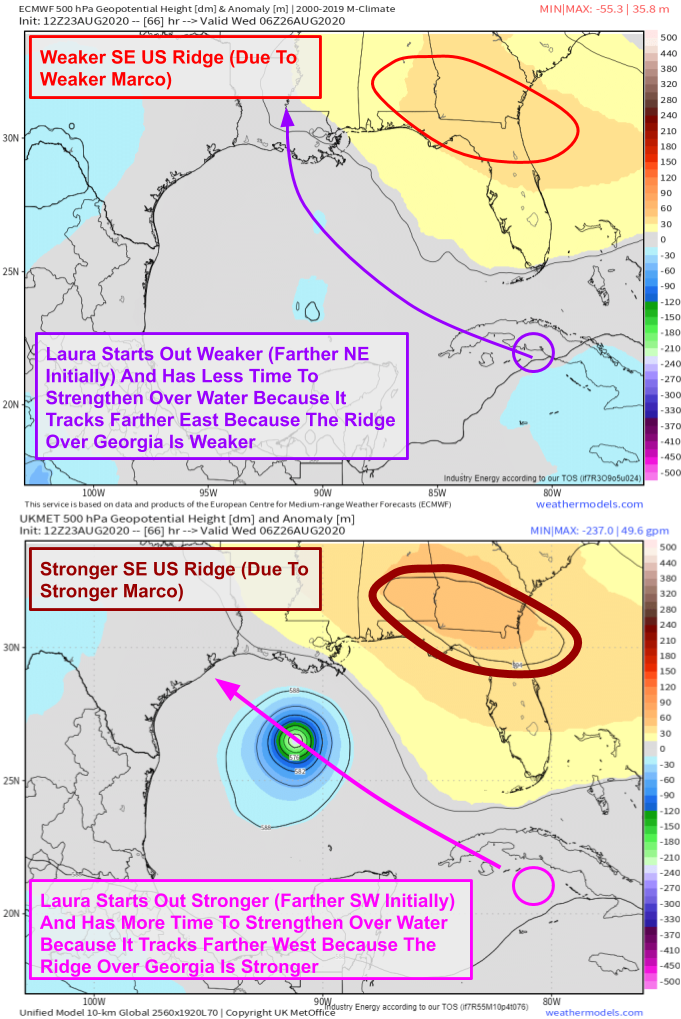 Marco’s role in Laura’s future is on the “time over the Gulf of Mexico available to strengthen” side of the equation.
Remember that tropical cyclones produce lots of warm upper-level outflow. That warm air has to go somewhere, and in the case of Marco, that somewhere is northeast of the center into the ridge developing over the Southeast US. So the more warm outflow Marco produces, the stronger that ridge will end up being.
That theoretical idea is backed up by our ECMWF vs UKMET comparison. The UKMET with its stronger depiction of Marco shows a much stronger ridge over GA/FL by Tuesday night compared to the ECMWF.
What’s the upshot of this? The stronger that ridge is, the farther SW Laura will end up tracking. The farther SW Laura goes, the more time it will have over the Gulf of Mexico to strengthen, and the stronger it will likely end up being. There’s also a feedback loop at play here: a stronger Laura moves farther SW due to how steering currents change with height then ends up stronger because it moved farther SW and has more time over water. This is the type of nonlinear feedback loop that is responsible for so much of the confusion among our models.
The next step in our analysis is to see how current observational trends match up (or don’t) with each modeled scenario. There are a few things we can look for in satellite imagery and Hurricane Hunter observations tonight: how strong Marco is, how strong Laura is, and where Laura is going.
We’ve already gone over the extreme versions of each scenario (weak Marco + weak Laura + Laura tracking farther north = much weaker Laura and vice versa), but what about the various possible permutations? What if Marco is weak but Laura is strong and tracking farther southwest or if Marco is weak and Laura is strong but tracks farther northeast?
Thankfully we can cross some of these scenarios off the list of consideration because each of these three variables are not independent meaning that an error or trend in one parameter will produce a predictable response in the other parameters of interest. I think it’s possible to see a weaker Marco and stronger Laura in the near-term because Marco isn’t really influencing Laura much at the moment. Same goes for a stronger Marco and weaker Laura tonight. I don’t think we see a stronger and farther northeast Laura track based on the duration of possible interaction with Cuba. Similarly, the favorable environment in the Caribbean means that I would find it hard to see Laura missing Cuba to the south and remaining weak. So if Laura is tracking farther south tonight, we can be fairly confident in tossing the extremely weak solution depicted by the ECMWF. Similarly, if Laura falls apart tonight, the very strong solution depicted by the UKMET would be very unlikely to wind up verifying.
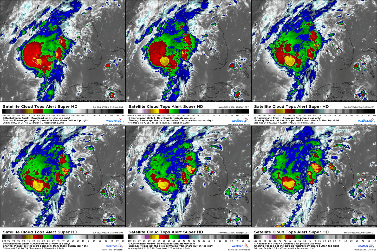
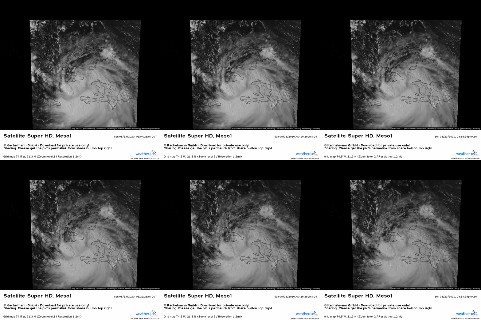 So what’s actually happening out in the real atmosphere this evening? Laura is looking fairly healthy on satellite imagery and has a robust circulation located south of Guantanamo Bay in Cuba. This is suggested by satellite imagery and confirmed by Hurricane Hunter observations as well as radar imagery from Guantanamo Bay. Hurricane Hunters found Laura a bit stronger than models suggested it would be by this evening (near or just below 1000mb with strong tropical storm-force winds). Furthermore, the center appears to be tracking almost due west. All this strongly points towards a solution where Laura is stronger and farther south/west than models currently expect.
A comparison of ECMWF and UKMET forecasts for 5 PM today against the 5 PM NHC advisory highlights the superior performance of the UKMET model in the near-term. While it’s still possible that the storm wobbles a little north, it seems like so far the ECMWF’s depiction of the storm as much weaker and farther northeast is unlikely to represent reality by tomorrow.
In the Gulf of Mexico, Marco’s convection seems to have waned a bit with DMIN but it is far from totally collapsed as the ECMWF indicates will happen this evening. Does that mean Marco will remain strong all night? Not necessarily. But so far, there are no signs that deviation from the going forecast of a relatively stronger Marco would be unwise.
So out of all this model confusion, after careful analysis of available guidance and observational information, I think we can get a pretty clear idea that the model guidance showing a stronger Laura and a track farther SW is much more likely to verify than the weaker/farther northeast solutions. Does that mean those solutions are set in stone? Definitely not! Laura could wobble back to the north tonight or tomorrow, it could struggle as it clips the mountains of SW Cuba, it could encounter some unexpected obstacles traversing the far northern Caribbean Sea tomorrow, or it could wind up losing some of its current structure due to land interaction or semi-random convective processes. But right now, all signs are pointing towards one solution and away from another if you look a bit beyond the topline end solutions of “major hurricane” or “tropical storm”.
-Jack
