Major Winter Storm To Impact Parts Of The Southern US This Weekend
Hello everyone!
A storms system currently bringing light rain and snow to parts of California will move east through the Rockies over the next couple days before emerging in Texas late on Friday. As the storm pulls Gulf of Mexico moisture north, and Canadian cold air south, a band of wintry precipitation will form from the Texas Panhandle all the way east to the Carolinas. This post will detail what to expect for the first phase of the system (western areas) as well as the uncertainties regarding the second phase of the system (in the Mid Atlantic/Southeast).
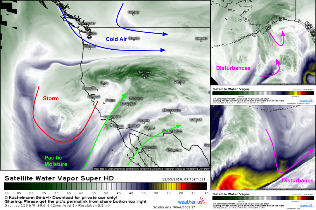
Here’s a look at where some of the elements important to the evolution of the storm are located this morning. Our main storm is a few hundred miles west of Los Angeles. Note the Pacific moisture streaming north on the eastern side of the system. That moisture tap will remain open as the storm traverses the Rockies and emerges onto the Southern Plains. Meanwhile, other disturbances are lurking farther to the west and northwest, both south of Alaska and south of the Aleutian Islands. However, the most critical disturbance that will determine whether the storm brings heavy snow farther north in the Mid Atlantic (including DC) is actually out of satellite range hundreds of miles north of the Northern Alaskan coastline. Maps via weather.us satellite imagery viewer.
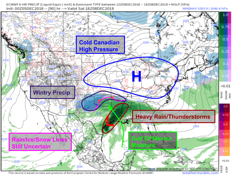
The first phase of the system in the Southern Plains only involves that California storm, so forecast confidence is much higher in the Texas/Oklahoma area than it is in the Carolinas. As the system ejects into Texas, low pressure will form near Houston. Warm moist air on the east side of the storm will be transported northwest towards the Texas Panhandle/Oklahoma area. Here it will encounter cold air from a high pressure system over the Great Lakes that moved south from Canada on Friday. The result will be snow, sleet, and ice where surface temperatures are cold enough. The exact rain/snow/ice lines have yet to be determined yet, but will likely be NW of the Dallas area, and quite close to the Oklahoma City area. Map via weathermodels.com.
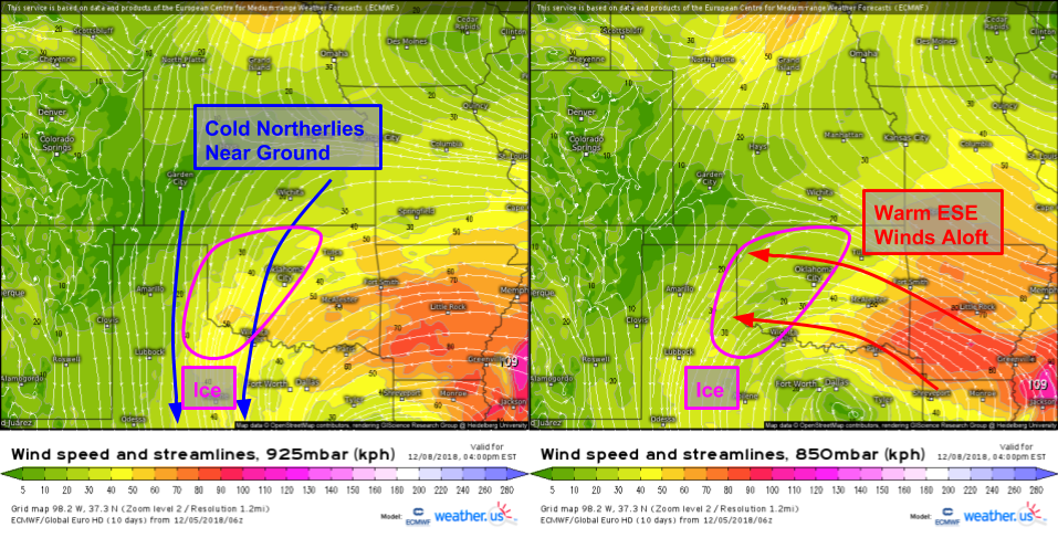
The winds in the lower atmosphere are conducive for freezing rain across parts of southwestern Oklahoma on Saturday. Warm air will be transported in at around 5,000 feet (right image) while cold air moves in closer to the surface (left image). It’s not a classic setup for a damaging ice storm, but ice could accumulate up to a half inch, which is more than enough to cause some problems. Farther west, not enough warm air will be able to arrive aloft to change snow over to ice, and farther south east not enough cold air will be able to arrive at the surface to cause falling raindrops to freeze on contact. We’ll continue to try to pin down the exact rain/snow/ice zones in the coming days!
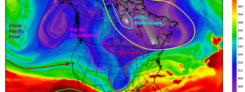
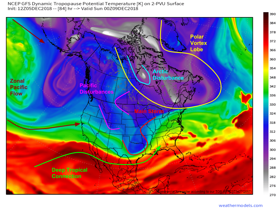
By Saturday night, the storm will be moving towards the Southeastern US, and the setup will be getting a bit more complicated aloft. This map displays the height of the tropopause, where the troposphere (lowest layer of the atmosphere) transitions to the stratosphere. It’s a good way to spot different airmasses as well as various upper level disturbances. The main storm shows up well over the TX-AR-OK area, while two Pacific disturbances are moving southeast over the Northern Rockies. Meanwhile to the northeast, a lobe of the Polar Vortex is anchored in NE Canada, with a strong Arctic disturbance travelling down its western flank. How all these disturbances interact will be crucial in determining exactly how the storm behaves. Map via weathermodels.com.
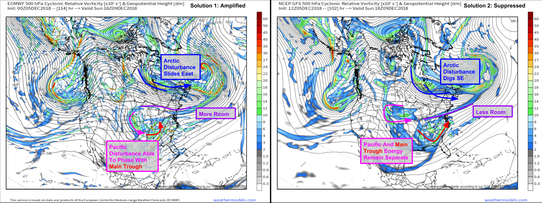
Here’s a look at two possible outcomes regarding how the disturbances might interact. The first possibility is that the Pacific disturbances are able to move fast enough to catch up with the main storm, becoming part of its circulation. This extra infusion of energy would allow the storm to strengthen, producing heavier precipitation. If that were to happen, it’s also likely that the Arctic disturbance moving through Hudson Bay would slide farther to the east instead of digging southeast. This would create a bit more room for the storm to come north as it emerges into the Atlantic. Note that this doesn’t mean the PHL/NYC/BOS corridor is in for a big storm, but it would put DC/NJ in play. The other possible outcome is that that Arctic disturbance digs farther southeast which drives a wedge between the Pacific disturbance and the main storm. This would prohibit the Pacific energy from interacting with the main storm, thus it would end up weaker and farther south. As of now, both solutions remain on the table! Maps via weathermodels.com.
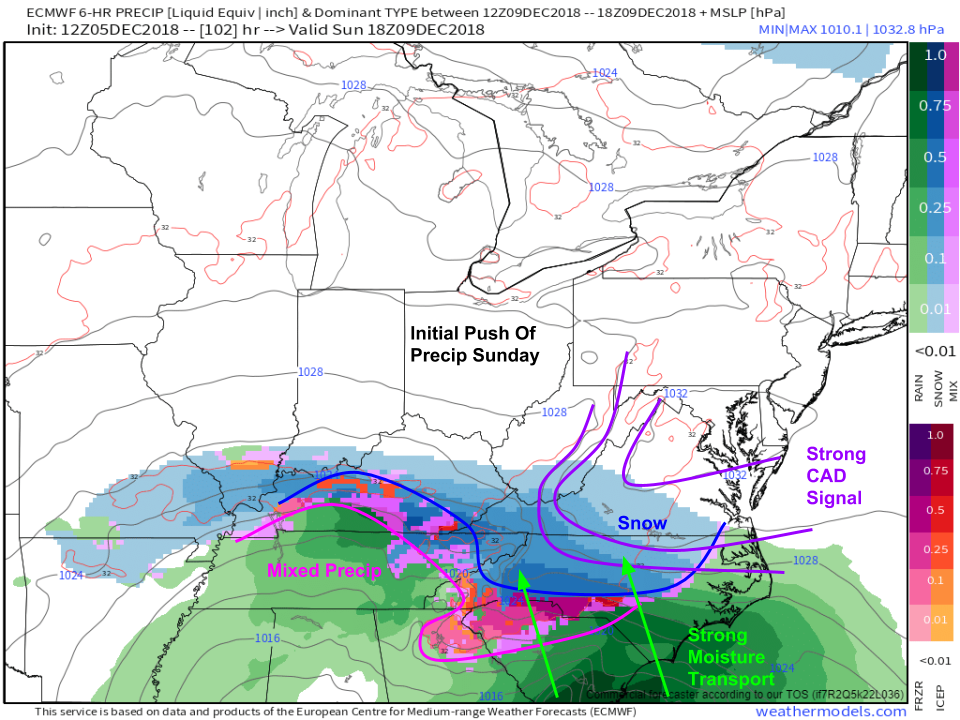
The initial push of precip will involve strong cold air damming east of the Appalachians. Snow will fall in SW VA, and most of NC away from the coast. As warm air moves in aloft over the top of low level cold air, sleet and ice will fall from S NC through NW SC into NE GA. Note that all these precip type zones could shift north or south depending on what all those disturbances end up doing. This map is from today’s ECMWF run which favored the more suppressed solution. Other models/runs have favored the more amplified solution, which would bring snow up into DC and mixed precip farther north into Central NC. Map via weathermodels.com.
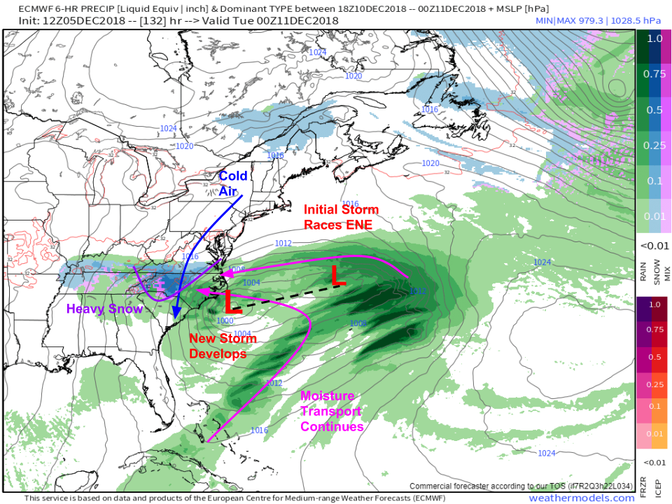
On Monday, the initial storm will likely be racing ENE towards Bermuda. Meanwhile, it looks like the system will develop another component closer to the NC coast, which could prolong the heavy snow over Central/Western NC. Of course, the exact evolution of this second component and the location of that potential heavy snow band will depend highly on how the disturbances discussed above evolve. Map via weathermodels.com.
At this range (4-6 days), ensemble guidance is still quite valuable, but beware as some of the maps can be misleading. Take for example one of my favorite maps for tracking East Coast storm potential: the EPS low locations map. It shows you not just the average sea level pressure forecast from all the ensemble members, but it also plots the location of each low pressure area from each individual ensemble member, which gives you a fuller picture of the range of possible outcomes. Here, two clusters of possible low locations are shown, one near the NC coast, and one much farther offshore. This may lead one to believe there are two possible outcomes: either the storm remains close to the coast (heavy snow) or it moves well offshore (little/no snow). However, inspecting individual ensemble member forecasts shows not two but three possible outcomes. Some of those lows are actually “double barrel” structures, with one low center near the coast and one offshore. Thankfully at weathermodels.com, you can see the individual ensemble member forecasts, which can help double check some of the aggregated ensemble products we have.
I’ll have more updates on the storm as it gets closer. Curious now what might be in store for your town? Harness the power of the ECMWF ensembles for your forecast with our Forecast Ensemble tool. You’ll be able to see not just the most likely forecast outcome, but also a range of possible outcomes that take into account much of the uncertainties described here. For more info, check out this tutorial video.
-Jack


Jack, great post and very timely as well. Your depth of expertise is appreciated
by those of us in the PSZ (potential snow zone) in the mid-Atlantic.
Do I get that snow shovel primed and ready to rock? Or just build
a fire and let it happen????
Thanks for filling the details