Major Storm To Impact Oregon And California Tomorrow
Hello everyone!
A major storm system will impact Oregon and California tomorrow with torrential rain, strong winds, and heavy snow for the mountains. This storm will be notable because of its unusually intense core, which will deliver winds near hurricane force to parts of the CA/OR coastline that usually don’t see the most intense winds from winter storms. This post will break down the meteorological processes that will fuel the storm’s explosive development, as well as some of the expected impacts. As always, if you’re looking for forecast information specific to your town, please head over to weather.us and make use of the tools available there. If you’re looking for a look at the forecast for pre-Thanksgiving travel, check out our post from Saturday which is still relevant, and will be updated again later today.
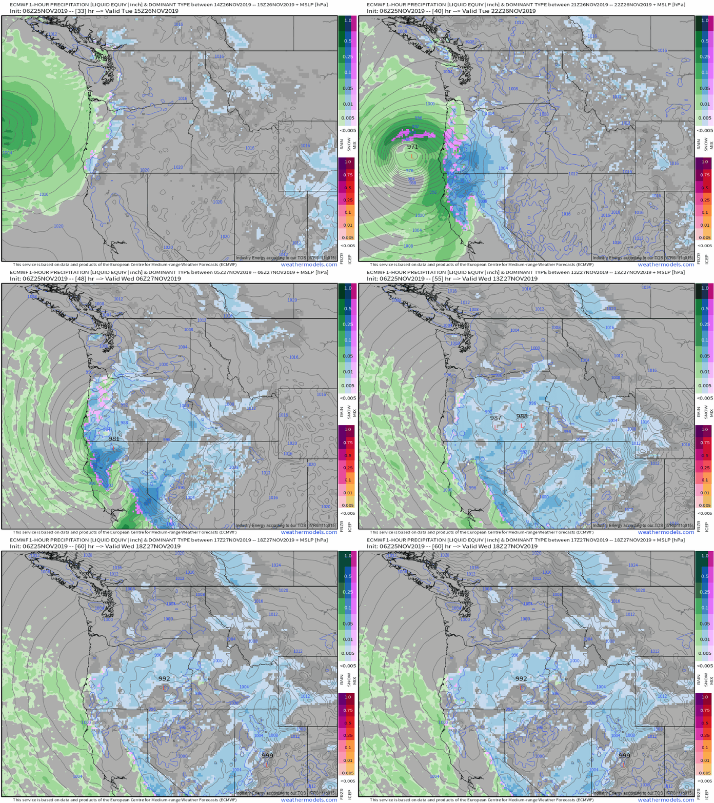
The storm’s components are currently scattered around the North Pacific, so instead of a satellite loop to start off the discussion today, here’s a look at the system’s general evolution as depicted by the ECMWF model’s hourly forecast guidance. Right off the bat, we can see that this system will be strong and well-organized. Depending on exactly how strong the storm gets, low pressure records may fall near the CA/OR border on Tuesday night. This is an unusually powerful storm for this latitude! The first half of the post will explain why the storm will get so strong, while the second half will take on the expected impacts. GIF via weathermodels.com.
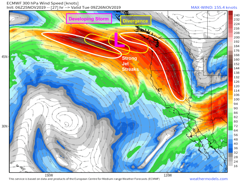
Beginning early tomorrow morning, we’ll see a ‘dual jet streak’ setup develop south of Alaska. This means that there will be two jet streaks (pockets of very fast winds embedded within the larger jet stream, shown above in white) located in close enough proximity to interact with each other. The eastern jet streak will be curved anticyclonically (turns to the right as you go east) while the western jet will begin relatively straight before curving cyclonically (turning to the left as you go east) later in the day. This means that divergence aloft will be maximized over the developing storm, located a few hundred miles west of Seattle. When air diverges aloft, it creates an area of lower pressure, which air from near the surface then rises to fill. This rising motion helps drive low pressure development at the surface, as well as clouds and precipitation. Map via weathermodels.com.
These jet dynamics will kick into an even higher gear tomorrow afternoon as the western jet streak intensifies. The storm will still be located in that ‘sweet spot’ between the two jets, which will help it rapidly intensify during the day tomorrow as it approaches Oregon and California. Map via weathermodels.com.
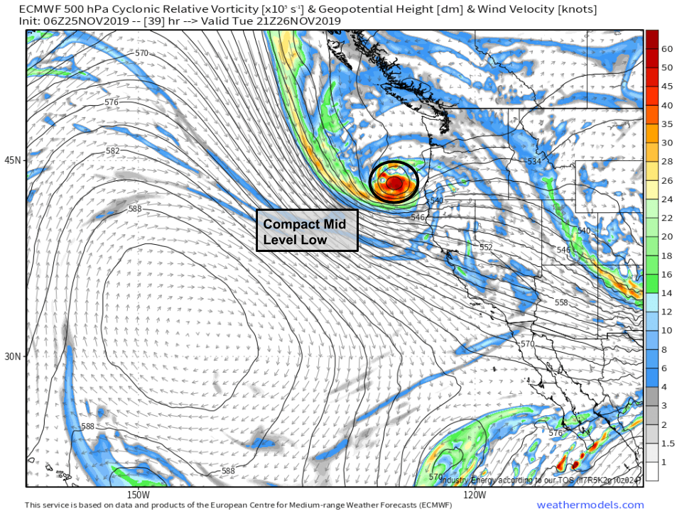
In the mid levels, a very strong closed low will develop in response to the jet streak dynamics discussed above. Several mid level disturbances will consolidate tomorrow as the trough deepens and drops southeastward. This consolidation will lead to a strong but compact mid level low located just NW of the surface low. As a result, the storm will become quite strong, but it will be on the relatively smaller side, and its worst impacts, particularly regarding strong winds, will be confined to a fairly narrow swath of the southern Oregon/northern California coast. Map via weathermodels.com.
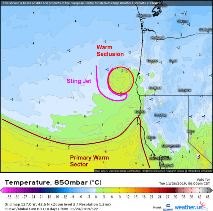
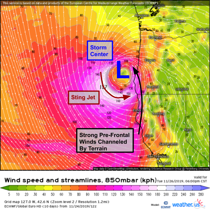
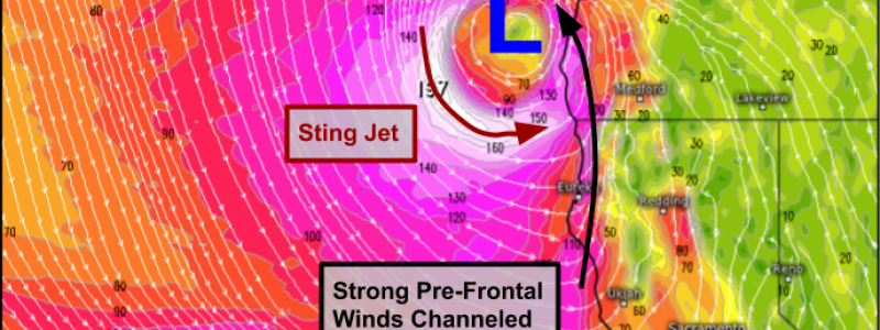
The storm’s strongest winds will develop SW of the low, and will be associated with a feature known as a ‘sting jet’. Sting jets form on the back side of ‘warm seclusion’ storms where a pocket of warm air in the mid levels becomes cut off from the primary warm sector. This storm is a perfect example of such a setup, as shown by the 850mb temperature forecast above. The storm’s primary warm sector is located west of San Francisco, but a pocket of warm air remains intact near the storm’s center NW of Eureka CA. Along the back side of that warm pocket, a powerful sting jet is expected to develop. If you want to know more about sting jets and how they work, check out this post from earlier this year. Note that the post is discussing a nor’easter off the East Coast, but very little is related to that specific storm’s forecast, and it takes a deep dive into the dynamics behind that storm’s sting jet, which will work in the same way as the storm off CA this week.
850mb wind forecasts for tomorrow afternoon highlight the sting jet perfectly. Winds at this level (about 5,000 feet above the ground) will almost certainly exceed 100 mph. The tricky part of the forecast for the CA/OR coast will be figuring out how much of that momentum can be transferred down to the surface. As of now, it looks like perhaps 60-70% of the winds at 850mb will be mixed to the surface based on lower atmosphere thermodynamic profiles and the dynamics associated with the sting jet which favor stronger momentum transfer than you’d typically expect in strong winds ahead of a cold front. This would support wind gusts of roughly 60-70 mph right along the coastline, with higher gusts possible in the adjacent mountains. While these winds will be capable of bringing down trees and powerlines, they will be confined to a relatively small part of the coastline roughly between Eureka and Crescent City. Another area of strong winds is likely ahead of the cold/occluded front, and while these will generally be less intense than the sting jet winds, the interaction between the winds and the terrain will likely produce pockets of 50-60 mph winds capable of tree/power line damage.
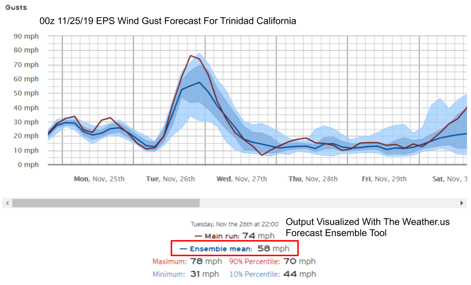
Here’s a look at our Forecast Ensemble output for the town of Trinidad CA, located roughly half way between Eureka and Crescent City. Note that while there remains some disagreement regarding exactly how strong the winds might get, there is strong agreement that gusts will range somewhere between 50 and 70 mph. Curious what this graph looks like for your town? Head on over to weather.us and type your town’s name into the search box to find out. Looking for more guidance on how to interpret these charts? Check out this tutorial video for a more thorough explanation.
With our discussion of the storm’s wind impacts complete, lets now move over to the precipitation-related impacts.
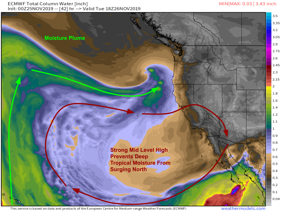
The first place to start when discussing a possible heavy precipitation event is always a map that looks something like this, which displays a parameter known as Precipitable Water, which represents the amount of rain that would fall if all the moisture in the atmosphere above a given point were to suddenly condense into liquid water. The moisture forecast for tomorrow afternoon does not resemble a classic California heavy precipitation event, as a mid level area of high pressure will block any northward movement of deep tropical moisture (PWAT values >2″) from the waters west of Mexico. Instead, this system’s moisture will take a roundabout path through the North Pacific, beginning near Hawaii before moving north ahead of an entirely separate storm system then making a sharp left towards the West Coast. The lack of a direct tropical connection means that we won’t be breaking any rainfall records with this storm, but that doesn’t mean there won’t be precipitation and lots of it. Map via weathermodels.com.
ECMWF precipitation forecasts call for a general 1-3″ of rain and liquid-equivalent snow as the storm moves onshore Tuesday-Thursday. The highest totals will be found in the coastal mountains of southern Oregon and Northern California as well as the Sierra Nevada. Most of the precipitation there will fall as snow, with 2-4 feet expected by the end of the week. While there will certainly be some minor to possibly moderate flooding, this is overall a beneficial storm for fire-weary California, and should basically end the fire season across the northern half of the state though of course a prolonged dry spell could bring dangerous conditions back at any time. GIF via weathermodels.com.
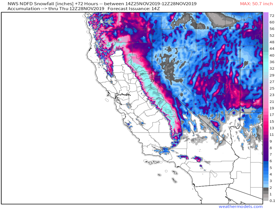
Here’s a look at the NWS snowfall forecast for the next 72 hours, which covers most of the upcoming event. Over four feet of snow could fall up in the high Sierras, which is great news both for water supplies and the ski industry, though it will make driving over the passes dangerous or even impossible Tuesday and Wednesday. Be sure to plan ahead if you need to get across the range for Thanksgiving! Map via weathermodels.com.
Rain and snow will shift into the central Rockies on Thursday as the storm moves steadily east.
-Jack
