Major Storm To Develop Off The East Coast Bringing Snow, Wind, And Cold
Hello everyone!
A major storm will develop off the East Coast in the next couple days, which will result in bitter cold temperatures and gusty NW winds for most of the eastern third of the country as well as snow, which could be heavy, for areas right along the coast. While the forecast for bitter cold and gusty winds is one filled with high confidence, the snow forecast is much trickier, and will be quite sensitive to small shifts in the track of the low.
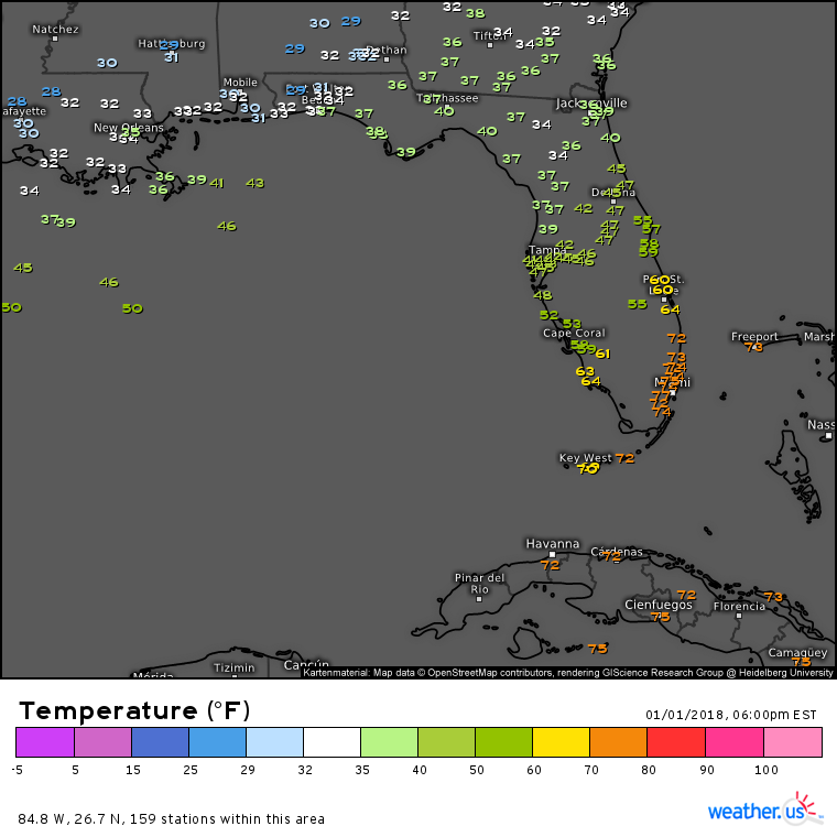
There are two basic ingredients for a strong extratropical storm like this one: a temperature gradient (baroclinic zone) and upper level kinetic energy (in the form of a disturbance, or area of enhanced winds). Our baroclinic zone is ready to go off the southeast coast as a strong Arctic front has moved just offshore and is now sitting about half way down the Florida peninsula.
A map of the current temperatures in Florida highlights this temperature gradient. Temps are below freezing all the way to the shores of the Gulf in the Panhandle area while Miami is enjoying an evening with temps hovering pleasantly in the 70’s. This large change in temperature over a short distance is a powder keg of potential energy that is waiting for a spark to ignite.
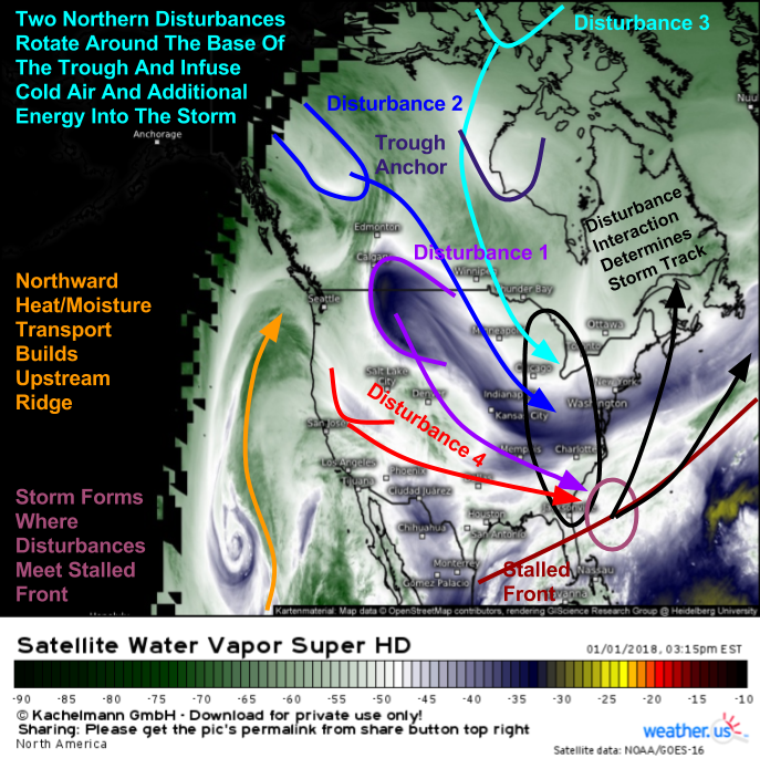
Water Vapor satellite imagery (what’s that?) shows plenty of sparks flying across the US and Canada as a variety of disturbances dive southeast towards the Gulf Stream waters.
I’ve marked the 4 disturbances most important to the formation, intensification, and tracking of our storm on this map. Disturbances 1 and 4 will combine tomorrow off the Florida coast and will result in the actual formation of the storm, which will initially be located just north of the Bahamas. Disturbances 2 and 3 will be much more important on Thursday as they will guide the storm either NNE closer to the coastline, or ENE farther offshore. Which track the system ends up taking will determine how much snow falls along the East Coast, and exactly how high wind gusts peak as the storm moves by. Regardless of the storm’s exact track, gusty winds and bitter cold air will be a dangerous combination for plants, pipes, and people who aren’t prepared.
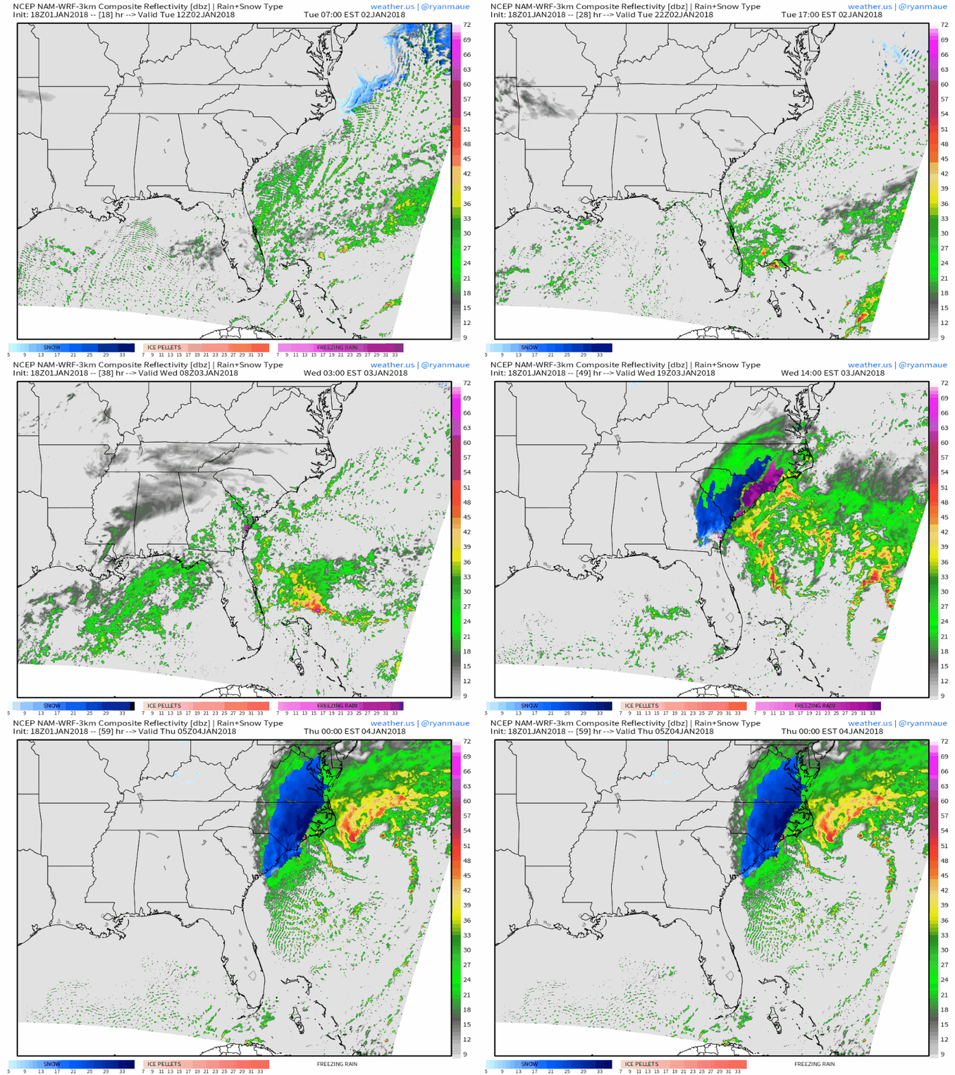
Here’s the NAM model’s depiction of what happens in terms of sensible weather as the cyclogenesis process takes place from tomorrow morning through Thursday morning. You can see the frontal boundary offshore, the beginnings of a surface low swirling near the northern Bahamas, and the incoming disturbance (light rain diving ESE through Arkansas into Mississippi/Alabama. Notice what happens when that disturbance encounters the front and surface low. There’s a rapid strengthening of the storm from a small swirl to a powerful cyclone. Also notice how far south frozen precipitation begins. Parts of northern Florida are likely to see a wintry mix of snow, sleet, and freezing rain from this system Wednesday morning as the cold air associated with the disturbance in the Northern Plains clashes with tropical moisture.
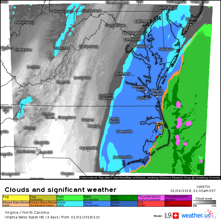
The next phase of the storm’s impacts occurs as it intensifies into a strong cyclone off the Carolina coast. This is when snow will begin to be a concern for the coastal Mid Atlantic from South Carolina and Georgia all the way up to New Jersey. Swiss Super HD model forecasts show rain as the dominant precipitation type along the Outer Banks while heavy snow falls just inland. Lighter snow is expected farther west at the edge of the system. How far west snow is able to move and how much falls will depend on the exact track of the storm, and how much moisture/lift it’s able to throw back westward as it intensifies.
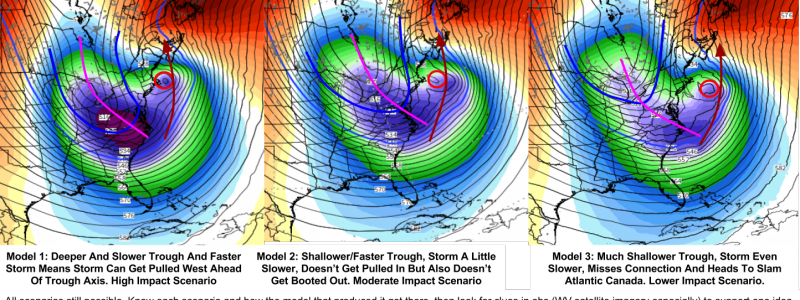
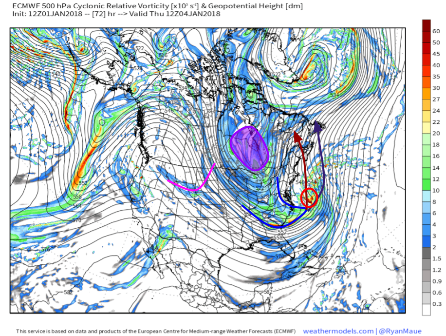
So what will determine the track of the storm? This map shows us the dynamics that will steer the storm either closer to the coast or farther away. The map shows 500mb heights and vorticity (mid level pressure/energy). The area of energy due south of Cape Cod (red circle) is the storm that formed in the Bahamas and rapidly intensified off the Carolinas. Additional energy from the Pacific and Polar regions will be dropping into a trough axis located just to the west of the storm (blue line). The big question is the exact strength, timing, and placement of both of these features.
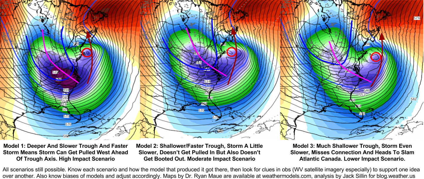
Here are three possible scenarios for the interaction between the incoming Pacific/Polar energy and the already-established storm system. The first scenario would be the highest impact, as the energy would enter the bottom of the trough strong and fast, leading to a slower and stronger trough axis overall, as well as an extension of the trough axis farther east. The net result of this process would be the storm having room to get pulled NW by the southeast winds ahead of the negatively tilted (NW-SE oriented) trough axis (at and above 500mb, known as the level of nondivergence, winds blow along the height lines with low the low heights always to the left of the wind direction). As a result, the core of heaviest snow and highest winds would be able to move onshore in parts of Eastern New England, while a much wider swath of the Northeast and Mid Atlantic would see at least some accumulating snow.
The second scenario would be a middle of the road option, where the trough is deep enough to tug the storm a little to the northwest, but the incoming energy isn’t quite strong enough to fully capture the storm. It would be strong enough to prevent the storm from getting kicked east, however, ensuring moderate impacts for New England and coastal parts of the Mid Atlantic.
The third scenario would be the lowest impact option, where the trough isn’t deep enough, and the incoming energy not strong enough to pull the storm northwest at all. Instead, it would kick the system ENE, limiting accumulating snow to the immediate coastline, and leaving most areas cold and dry.
How do you make sense of all this uncertainty? We have a few tools at weather.us designed to help you do just that, and Forecast Ensemble is one of the best.
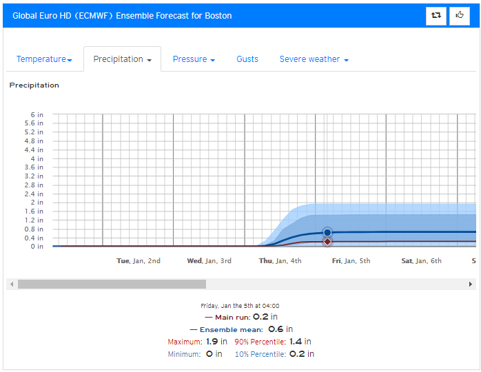
This is our Forecast Ensemble product for Boston showing uncertainty in QPF (Quantitative Precipitation Forecast) values through Friday due to the storm. I’m using the QPF product instead of the snow depth product because all the precipitation is expected to fall as snow for anyone not on Cape Cod due to the impressive Arctic airmass in place currently. Also, looking at QPF values lets you pick your own snow to liquid ratio instead of relying on the model’s attempts to figure that out.
The min/max values of 0 and 1.9 inches respectively represent the very best and very worst case scenarios. It is possible (though very unlikely) that Boston escapes without seeing a single flake. This would happen if and only if a chain of drastic and unexpected changes occurs with several of our disturbances. Is it possible hypothetically? sure. Is it a realistic possibility? not really. It is also possible, that through a series of equally drastic and improbable events that Boston ends up with 1.9″ of QPF, which would translate to around 2 feet of snow. Again, while this is hypothetically possible, it’s quite unlikely.
The better values to focus on to give you a range of reasonably possible potential outcomes are the 10th and 90th percentiles. These are the QPF values that have a 90% and 10% chance respectively of being exceeded. There’s a 90% that Boston will get more than .2″ of QPF, which would be around 2″ of snow. There’s only a 10% chance that more than 1.4″ of QPF will fall, which would translate to a little over a foot of snow. Notice the large spread between these values. This signals high uncertainty, something we already saw and attributed to the sensitive interactions between the variety of upper level disturbances. As the storm approaches and the forecast becomes a little clearer, these numbers will get closer together, signaling that the model is honing in on the final outcome.
You can get Forecast Ensemble output for any town/city in the world at weather.us, just type the location you’re looking for into the search bar and you’re good to go!
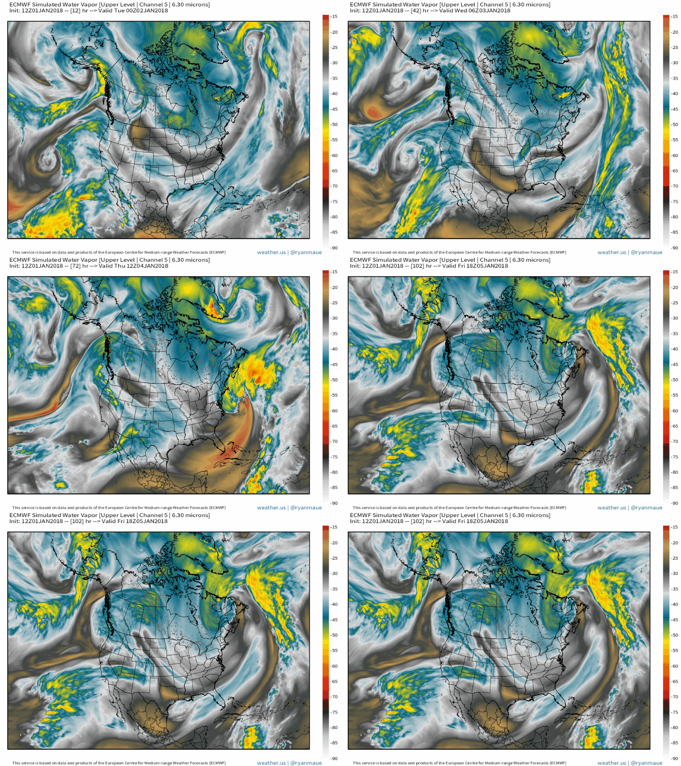
Here’s a loop of what the ECMWF model thinks water vapor satellite imagery will show as the storm evolves in the next couple days. While the exact track of the system has yet to be ironed out, there is very high confidence in an extremely impressive cyclogenesis event occurring. The storm will become extremely large in both its wind field and its precipitation shield, meaning that even if the track ends up being a couple hundred miles offshore, snow and wind will still bring impacts to parts of the coast.
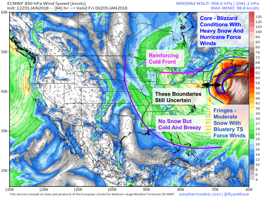
This map from the ECMWF shows the storm’s massive wind field, stretching from the Mississippi River out into the Central Atlantic. Even if you’re over a thousand miles from the storm’s center, you’ll be feeling its effects in the form of a very cold NW wind. Closer to the center will be the storm’s core where the most intense conditions will be found. In the area within 50-100mi of the center, bands of heavy snow are expected along with wind gusts to hurricane force. Whether these conditions impact the coastal parts of New England or remain just offshore is still TBD. The next “layer” of the storm is the fringe where snow will be falling at light to moderate rates, and winds, while not as ferocious as in the core, will still be quite gusty. Even in this area, travel will be difficult due to the falling and blowing snow.
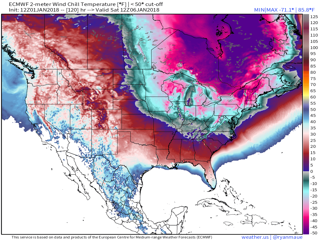
Behind the storm, bitter cold air will pour south. This map shows wind chills Saturday morning, when subzero values will extend as far south as Georgia. In the Northeast, values will drop below -20 for much of New England, including the coastline. Take proper precautions if you plan to be outside in the frigid weather!
Several of the maps used in this post come from weathermodels.com, our new subscription service at weather.us. Be sure to sign up for a free trial anytime before January 25th to give it a try!
I’ll have much more on this storm as it evolves in the coming days.
-Jack


What do I do if I have a flight Friday night?!
No worries for Friday night, storm will be long gone by then. Just a matter of airline logistics
I really like the forecast ensemble product. I’ve saved your forecast from a few days ago so I can keep returning to the link to see most recent prediction. Can I get to this from the weather.us website?
Yep, on our homepage mouse over the “Forecast” tab at the top left then select “Forecast Ensemble” https://weather.us/forecast/ensemble then type in whichever location you want
Beautifully crafted post, Jack. Thank you!