Major Severe Weather Expected Today Across Parts Of The Midwest
Hello everyone!
Today will feature a very active day for severe weather as a powerful cold front drives east through an unstable, moisture-rich airmass. Storms will develop this afternoon along the cold front, which will extend to the south of a developing surface low moving through Illinois. To the north of the low, a fairly major winter storm is already beginning across parts of Minnesota, Iowa, Nebraska, and South Dakota this morning. Snow bands in this area will continue to intensify and shift east through the day today as the storm gets going. To the southeast of the low, the main story will be severe weather. Storms developing on and ahead of the cold front will be capable of all severe hazards, from very large hail to widespread damaging winds, and even including the potential for some tornadoes.
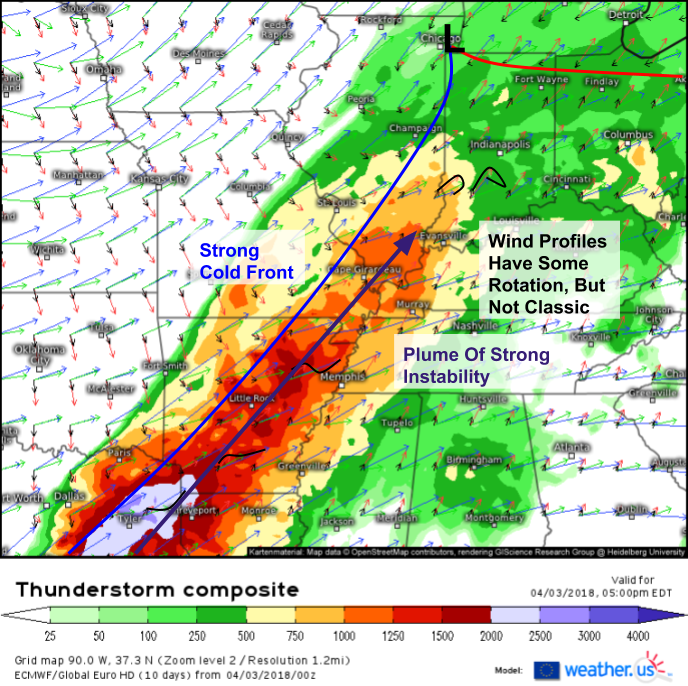
The ECMWF’s thunderstorm composite product (what’s that?) does a good job highlighting some of the overall characteristics of the setup today. The primary feature to watch will be the very strong cold front crashing southeast. This front will provide more than enough forcing to get widespread storm development, and the upper level winds associated with the airmass change will help storms quickly organize into line segments. These line segments will mainly be damaging wind threats, though tornadoes and hail are also possible. Wind profiles don’t show the classic uniform strengthening and veering with height that we typically look for to support tornadoes, but there is some rotation in the atmosphere as shown by the looped profiles in S IL/IN. Also of note is the plume of strong instability with CAPE values over 1,000 J/kg fairly widespread. All the ingredients are in place for a widespread damaging wind event in this area, with tornadoes and hail being secondary threats.
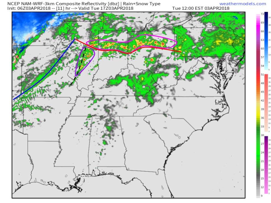
Here’s a look at the NAM’s simulated radar forecast for noon today. We can see storms existing along two boundaries by that time. First, we have the warm front extending from Illinois across Indiana and into Ohio. Storms are already ongoing along this boundary this morning, as seen by HD radar imagery from the area. Because storms will be “training” over the same areas for hours, flash flooding will be the primary concern with these storms. As these storms interact with the warm front, there’s a chance that one or two of them could tap into the front’s rotational energy and drop a quick tornado. That chance is fairly low, but nonzero. The other boundary to watch early in the afternoon will be a prefrontal trough in Illinois. Storms developing along this trough will have to be watched for all severe hazards as they could briefly exist as individual cells before merging into a line. Map via weathermodels.com.
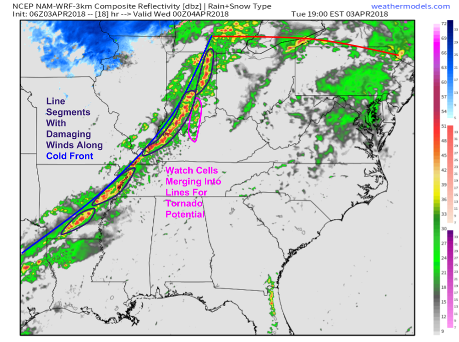
By later in the evening, storms will have formed along the cold front itself and will be organizing into line segments capable of fairly widespread damaging winds. Any cells that can pop up ahead of the line, then merge into the line will have to be watched for some tornado potential as well, though damaging winds will be the main threat. Map via weathermodels.com.
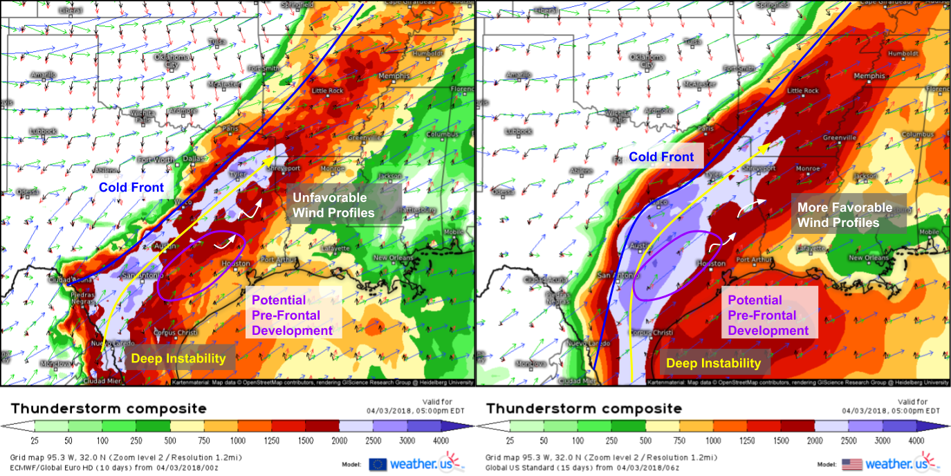
Farther south in Texas, severe weather is also expected today. The greatest uncertainty in this area revolves around wind profiles in an area ahead of the front that could be conducive to pre-frontal development. The ECMWF (left) and GFS (right) agree on deep instability ahead of the cold front, and mesoscale models (such as the NAM and HRRR which we’ll look at in a moment) both point to potential discrete storm development ahead of the front. However, the GFS and ECMWF disagree greatly on what vertical wind profiles will look like in this area this evening. The ECMWF has winds backing with height, typically unfavorable for supercells. However, the GFS has winds doing the opposite: veering with height, which would be conducive to one or two of those discrete cells becoming supercellular in nature. These cells, if they develop, and especially if they acquire some supercellular characteristics could produce very large hail in addition to damaging winds and potentially even a tornado.
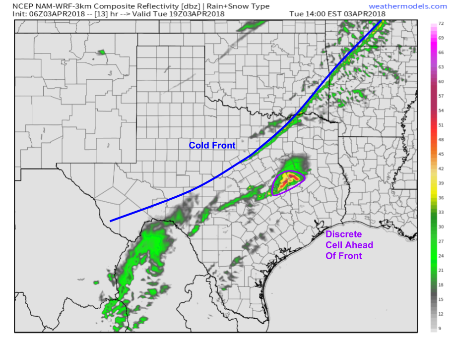
Here’s the NAM’s depiction of what the radar may look like at 2 PM this afternoon showing a discrete cell out ahead of the cold front. Whether a cell like this develops is uncertain, but if it does, it will likely exist in a very favorable environment. Either way, it won’t be long before storms erupt along the cold front and the primary threat goes over to damaging winds associated with linear storm structures. Map via weathermodels.com.
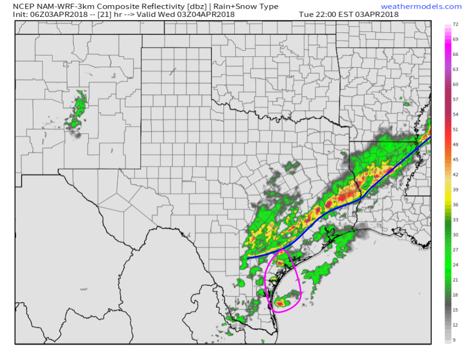
Here’s a NAM simulated radar forecast for later in the evening highlighting this transition towards a more linear storm mode as the cold front crashes towards the coast. Damaging winds will be the main threat from this line. Farther south, there are some hints at discrete convection near Corpus Christi. We’ll have to watch to see if these storms actually develop, but if they do, they may prolong the hail/tornado threat a little later into the evening for that area. Map via weathermodels.com.
Track all the storms today with the tools we have at weather.us. Follow large scale developments with nationwide GOES-East WV satellite imagery https://weather.us/satellite/usa/satellite-water-vapor-superhd-5min.html#play, and keep track of smaller scale features with zoomed in satellite imagery down to county level/1 minute resolution https://weather.us/satellite/kansas/satellite-superhd2-1min.html#play. Once storms form, follow their every move with our HD radar https://weather.us/radar-us/illinois/reflectivity/KIND.html#play and stormtracking products https://weather.us/radar-us/illinois/stormtracking/KIND.html#play, and keep track of where lightning is striking with lightning analysis https://weather.us/lightning/illinois/20180403-1335z.html, which provides strike locations down to street level if you click to zoom to a specific county then click the (+) or (-) icon of an individual strike.
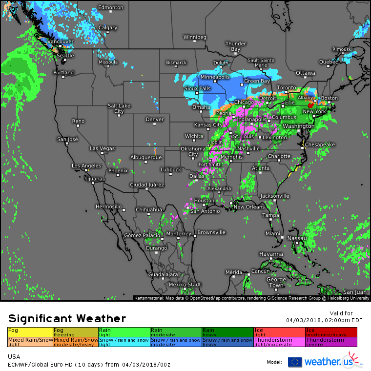
Elsewhere across the country today, the system responsible for the severe storms will bring other more wintry impacts to areas farther north. Heavy snow will fall across parts of Minnesota, Iowa, and Wisconsin on the northwest side of the low, while snow will change to freezing rain and sleet across parts of upstate New York and New England on the northeast side of the low. Quiet weather will dominate the West Coast today under a large upper level ridge.
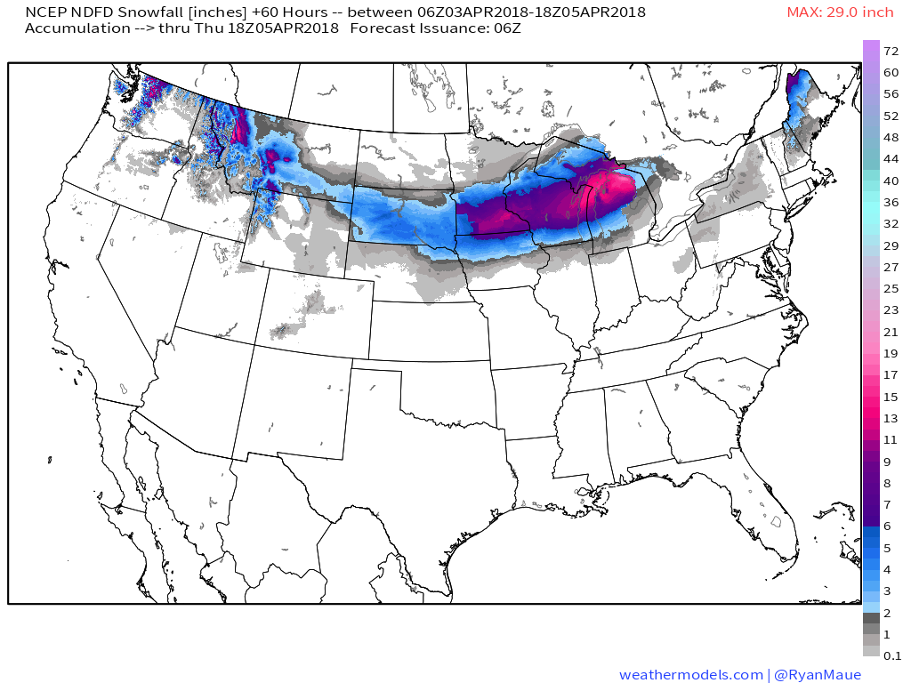
How much snow is expected from this system? Areas from Southern MN through Central WI and into Northern MI will see over 6″ of snow, with some amounts in this area locally approaching a foot depending on exactly how banding sets up. Lighter amounts are falling currently in parts of Nebraska and South Dakota. Snow will also accumulate on the front side of the storm in parts of upstate NY and New England, but amounts here will be lighter due to the marginal airmass. For more on what to expect in NY/New England from this system, refer to our Swiss Super HD model forecast for that part of the country https://weather.us/model-charts/newengland/new-england/significant-weather-extended/20180404-0100z.html. Snow map via weathermodels.com.
I’ll be following the storms on twitter this evening, providing updates over at @WeatherdotUS, so follow along there starting around 5 PM.
For more information on your local forecast: https://weather.us/
For more information on the local forecast for ME/NH today: https://forecasterjack.com/2018/04/03/snow-arrives-this-afternoon-changes-to-sleet-and-ice-this-evening/
-Jack
