Major Nor’easter To Bring Heavy Snow And High Winds To The Northeast Wednesday/Thursday
Hello everyone!
Less than a week after the last major Nor’easter brought hurricane force wind gusts and major coastal flooding to parts of the Northeast, another storm is forecast to rapidly develop off the New England coastline over the next couple days. This storm, while less intense than the last one, will produce bands of extremely heavy snow along with another round of strong winds and coastal impacts. Unlike the last storm, snowfall will by far be this storm’s most impactful element, with a wide swath of 6-12″ expected, and some localized amounts well over a foot possible in mountainous areas of interior New York/New England.
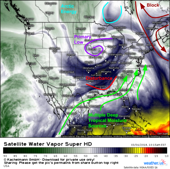
As always, it’s helpful to start with GOES-East Water Vapor satellite imagery (what’s that?) when discussing an upcoming storm to see the important features that will play a part in the storm’s development/evolution. The main feature visible this morning is an occluded low over Iowa. This is the remnant of the system that I discussed on Sunday evening that brought blizzard conditions and severe storms to the Central US yesterday. It is weakening as it moves south, and meanwhile a strong disturbance is crashing into its cold front over the Deep South. The interaction between this disturbance, the cold front, and soon the Atlantic Ocean will drive secondary low development off Cape Hatteras tonight. It’s that secondary low that will tap deep tropical moisture from the East Pacific, the Gulf of Mexico, and the Atlantic as it rapidly develops and moves north tomorrow. Meanwhile, Arctic energy will be diving south from James Bay, simultaneously steering the storm up the coast and providing an additional source of cold air. Strong blocking over the Atlantic will be an additional factor that prohibits this storm from escaping out to sea.
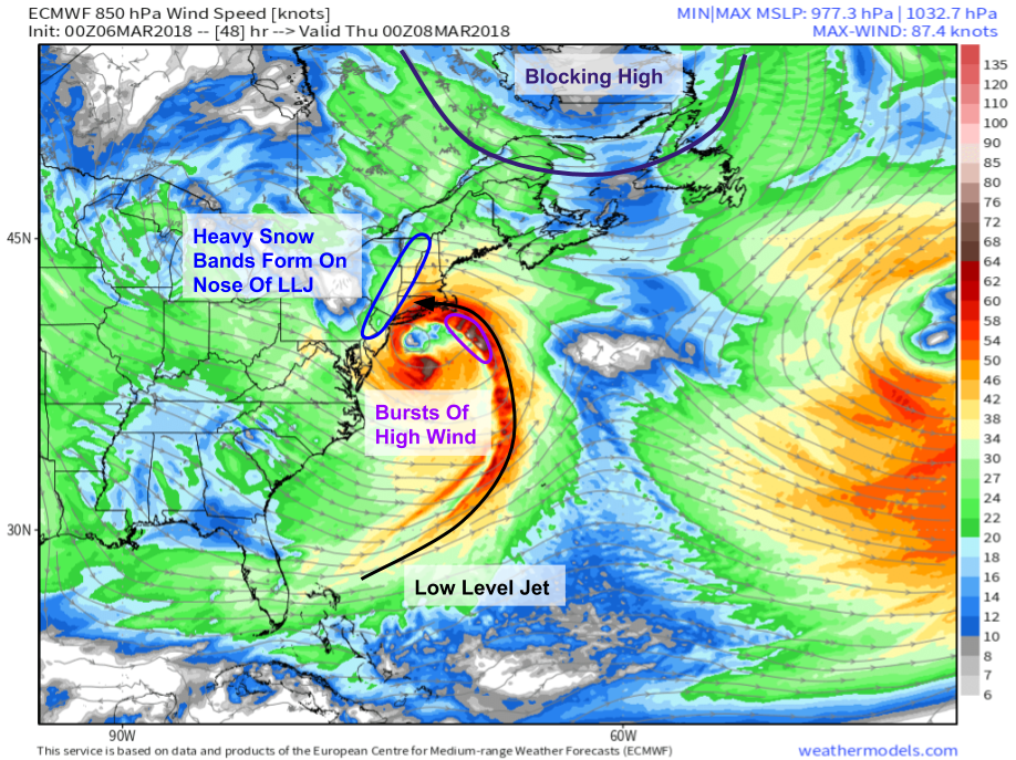
A look at the 5,000 foot level, we can see this will be another strong, well-organized system. A low level jet sourced from the Bahamas will curl north then northwest towards the center of the low just SE of NYC. Bursts of high wind will be embedded within the LLJ and will bring more wind gusts above 50 mph to Cape Cod, though wind gusts to hurricane force are not expected unlike last time. That being said, given that trees are already weakened/leaning, 50 mph wind gusts from this storm will be much more impactful than 50 mph wind gusts normally are. Meanwhile to the northwest, bands of heavy snow will form along the nose of the LLJ as warm, moisture laden air transported in on the LLJ crashes into the existing cold airmass.
Map via weathermodels.com.
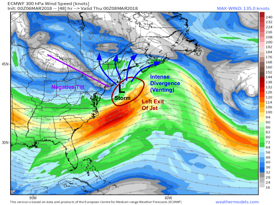
At the upper level jet stream level, ECMWF forecasts show a setup ripe for strong upward motion located over our developing storm system tomorrow evening. A strong jet streak will exit the East Coast tomorrow afternoon, and the storm will be developing right in its left exit region. This is an area known to favor large scale rising motion, favorable to the strengthening of surface storms. Additionally, winds north of the storm are shown spreading out (diverging) which will serve two purposes to enhance snowfall in New England. First, it will help contribute to upward motion because as air races away from itself in the upper levels, an area of low pressure forms. Air from the lower levels then rises to fill this void, resulting in upward motion. Second, it will help transport moisture from the storm’s center northwest. The negative tilt of the trough west of the storm will help this process by favoring southeast winds aloft. That negative tilt will also help keep the storm close to the coast instead of moving east.
Map via weathermodels.com.
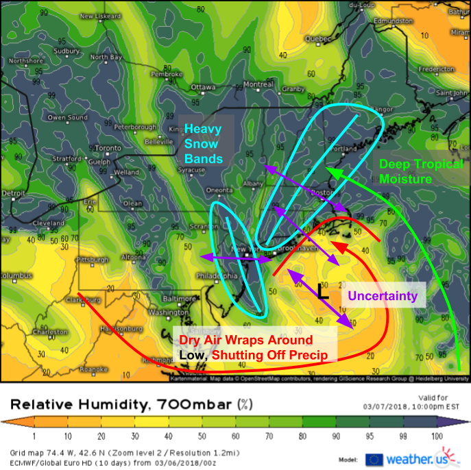
I’ve talked before about how cyclogenesis (the process of forming a cyclone) happens from the bottom up, with the new low appearing later and farther NW as you go up in the atmosphere. While the surface low will form off of Cape Hatteras tonight, the secondary low at 700mb (about 10,000 feet) won’t form until tomorrow afternoon in the vicinity of the Jersey Shore. While we’re fairly confident in the track of the primary upper level features at this point, the track of lower level features is much more uncertain.
Here’s a look at the ECMWF’s forecast for the relative humidity at 700mb tomorrow night. As you can see, this layer is primarily responsible for the evolution of a large number of the storm’s features. Two areas favored for heavy snow bands are visible, one to the north of the low where the moisture laden LLJ fans out as it hits the cold air, and another to the WNW of the low where intense frontogenesis will be occurring. Frontogenesis is the process of the creation of a front, which manifests itself as a strengthening of the horizontal temperature gradient with time. This can only occur if two different airmasses are forced together, a process that results in upward motion. There is some uncertainty as to the exact placement of the 700mb low, however, and as a result, the exact location of the heavy snow bands remains in question. Additionally, the relative humidity map shows dry air wrapping around the south side of the low and into SE New England. This so-called “dry slot” will shut off precipitation wherever it moves ashore, resulting in significantly lowered snowfall totals.
Now that we have a good sense of the overall setup and dynamics behind this storm, we can take a look at more specific timing/impacts. For this, we turn from the larger scale global weather models (ECMWF, GFS, CMC, ICON etc.) towards the smaller scale mesoscale weather models that are run for a shorter time, but at a much higher spatiotemporal resolution. Mesoscale models include the NAM, HRRR, and of course the highest resolution one of them all, the Swiss Super HD.
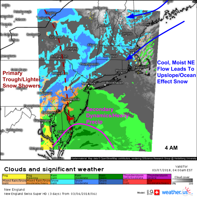
This Swiss Super HD forecast shows our storm getting going early tomorrow morning across parts of the Northern Mid Atlantic and western Northeast. Precipitation is already moving into parts of PA, MD, and VA in association with the primary frontal boundary leftover from the Great Plains low. This precip is generally light, and won’t amount to much. It’s only once the secondary coastal storm gets going that things really ramp up. That process will be just beginning at 4 AM, when bands of heavy rain will be moving onshore along the beaches of Delaware and SE New Jersey.
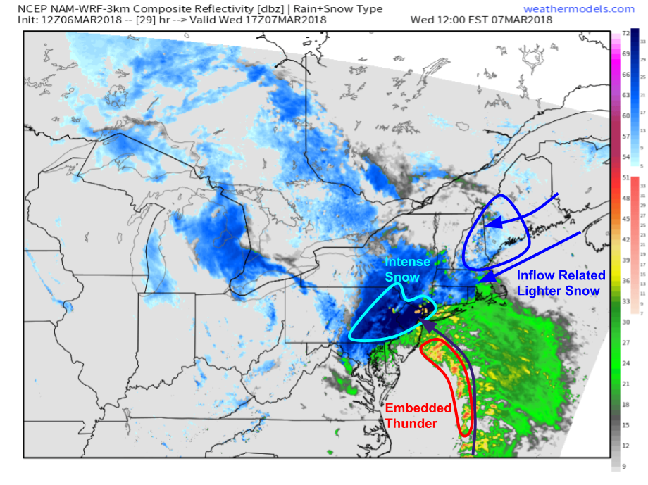
As the morning wears on tomorrow, the secondary low will rapidly be developing and as a result, bands of heavy snow will begin impacting NE PA, NNJ, and SE NY near and just NW of NYC. A line of thunderstorms will form along the edge of the low level jet discussed above, and these storms will bring pockets of gusty wind and enhanced precipitation to the NJ coast as they move ashore. Meanwhile farther to the northeast, evidence of cold, moist inflow is seen over New England where light snow will begin to fall well ahead of the main storm system due to a combination of upslope in NW NH/ME and Ocean Effect in SE NH/MA.
Map via weathermodels.com.
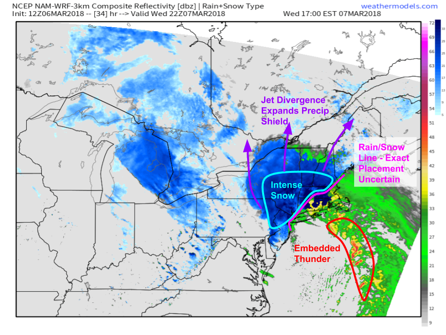
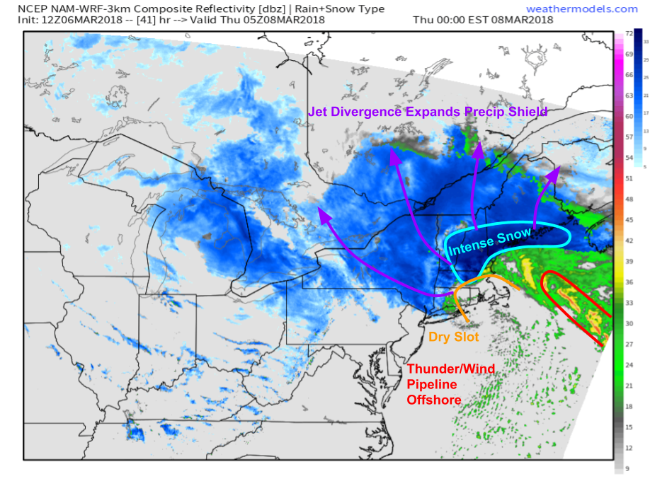
By tomorrow evening, intense snow will be ongoing across much of NNJ and SE NY away from NYC, and will begin to spread east into New England. The jet streak divergence discussed earlier will help fan the precipitation shield out and away from the center of the storm, which will lead to moderate snow from Syracuse NY all the way into the mountains of NH and ME. Meanwhile, the rain/snow line will be wavering across CT, RI, and SE MA. The exact placement of the rain/snow line is still uncertain, but it will make all the difference in totals for areas right along it. Currently, areas west of Boston and north of Hartford CT stand the best chance at remaining mostly snow, while Cape Cod is very likely to remain all rain. It’s that transition zone right along I-95 that’s most uncertain. If the rain/snow line ends up even 5 or 10 miles farther east, folks expecting 3″ now may end up with 12″, and if the line ends up farther west it will have the opposite effect on totals.
Map via weathermodels.com.
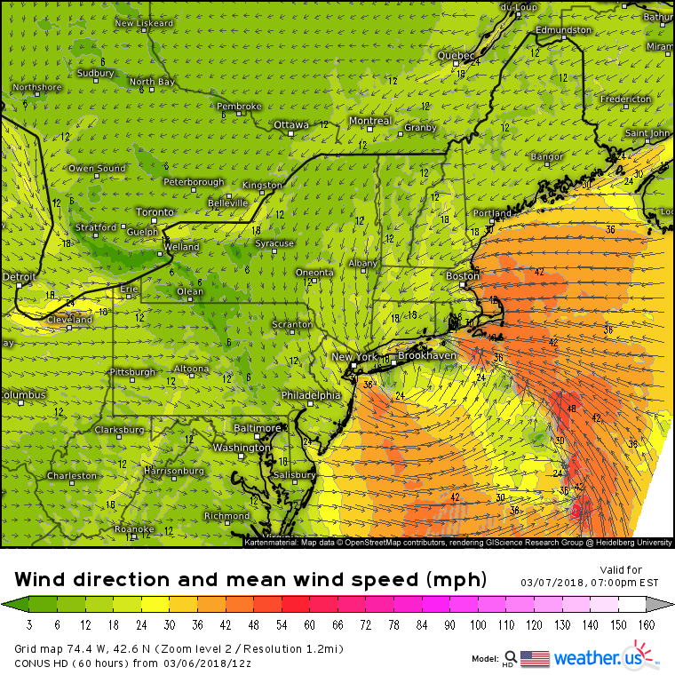
The pipeline of convection that was aimed at coastal NJ earlier in the day will point itself at Cape Cod, where rumbles of thunder and wind gusts over 55 mph are expected. The map above from the NAM model shows pockets of enhanced winds in that pipeline of convection tomorrow evening. In those pockets, sustained winds of 40+ mph are expected, with gusts over 55 mph. However, these bursts will be nowhere near as powerful as those on Friday, when winds gusted over 90 mph on Cape Cod. While the winds from a storm like this would ordinarily be quite manageable, considering that trees have been significantly weakened by Friday’s storm, expect much more widespread tree/power line damage than in a typical 55 mph Nor’easter event.
The same processes will continue into tomorrow night as the storm lifts northeast. Bands of intense snow will move into NH/ME as the dry slot discussed above punches into SE New England. Jet divergence will continue to expand the precipitation shield, with moderate snow extending hundreds of miles from the most intense band near the core of the system. The pipeline of convective elements will shift east of Cape Cod, and will no longer be an issue as the storm begins to occlude and weaken slowly over the Gulf of Maine.
For more specific timing rundowns hour by hour, check out the full 3km NAM model run I’ve grabbed parts of here on weathermodels.com.
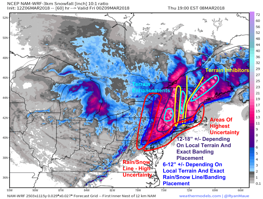
Here’s a general look at how much snow can be expected from this system, with the 3 km NAM used as a backdrop. The model isn’t perfect, and some of its snow forecasts are greatly overdone, but I think it does a good job picking out the overall distribution of snow totals, as well as where terrain will enhance or detract from snowfall amounts. A general 6-12″ will be widespread from this storm, with amounts over a foot expected in the higher terrain of NE PA, NNJ, ENY, and northeast into interior New England. Higher elevations such as the Catskills, Greens, and Whites/Longfellows will see amounts well over a foot, perhaps even up to two feet. Meanwhile, the lower elevations of the Hudson and Connecticut river valleys will see lower amounts in the 4-8″ range. The most uncertain areas are at the edges of the heaviest snow zone. The rain/snow line will cause problems from DC through NYC and up towards Boston, while it remains to be seen how much moisture can wrap back into central PA/NY, making predictions uncertain there as well. For more information on how much snow is expected in your town, check out the town-specific information we have at weather.us including our basic overview and more detailed model/ensemble comparisons that highlight forecast uncertainty.
Map via weathermodels.com.
This system will stall out over Maine Thursday evening, with any snow limited to the higher elevations of Northern New England at that point. Quiet weather will then return to the East as we move into the weekend.
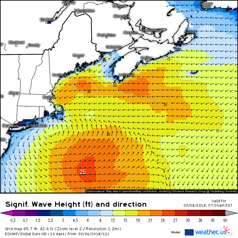
In addition to the snow and wind impacts discussed above, ECMWF forecasts also indicate renewed wave action developing as ENE winds funnel water back towards the coastline while the system intensifies. These waves will not be as massive as those we saw on Friday, nor will tides or storm surge be as high. However, our coastal defenses are severely bruised after the beating they took from that last storm. Seawalls are crumbling and dunes are already eroded. This will make coastal impacts from this storm much more significant than those from a typical Nor’easter of this strength. The bar for significant impacts has dropped quite a bit due to the preceding storm. Take precautions for additional erosion and local inundation from this storm if you live in coastal MA, NH, or southern ME.
Watch this system take shape through the several different lenses we offer at weather.us to analyze current weather. GOES-East visible satellite imagery (https://weather.us/satellite/799-w-396-n/satellite-superhd-15min.html#play2) will let you see where clouds are right now, while water vapor imagery (https://weather.us/satellite/799-w-396-n/satellite-water-vapor-superhd-15min.html#play2) will let you look at the mid/upper level features driving the system. IR satellite imagery (https://weather.us/satellite/799-w-396-n/top-alert-superhd-15min.html#play2) serves as a good substitute when visible imagery is unavailable during the day. HD radar imagery (https://weather.us/radar-us/usa-east/#play2) will be your tool of choice to watch as bands of heavy rain/snow develop tonight and tomorrow. Click the SD regional composite image for state level HD imagery, then click again to zoom to county level for a look at what’s happening in your town. Curious what’s actually being observed on the ground, not just sensed aloft by satellite or radar? We also have current observations (https://weather.us/observations/weather-observation.html) available across the US (and the world) that update each hour with the latest data. Use the menus to the left of the image to select additional observation parameters.
Enjoy the snow!
-Jack
