Major Hurricane Harvey Set To Devastate Parts Of Coastal Texas
Hello everyone!
Hurricane Harvey has now intensified into a Category 3 storm with winds of 120 mph. It is closing in on the Texas coastline, where it will make landfall tonight. Not much has changed with the storm’s presentation on radar and satellite. The inner core did undergo an Eyewall Replacement Cycle which happens when the thunderstorms in the eyewall (inner core) spin so fast that they collapse, leaving more organized storms slightly farther out to take over. This process is now complete and after a pause in strengthening this morning, the storm has resumed intensification.
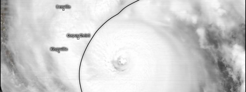
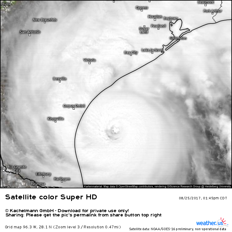
GOES-16 satellite loops show the storm continues to look very healthy. Dry air continues to spiral into the storm from the east and south which is likely the only reason we’re not looking at a Category 4 or 5 storm at the moment. The eye of the storm has cleared out nicely with very strong thunderstorms forming a complete ring around the center. Strong thunderstorms are also noted farther away from the center, moving onshore in the outer spiral bands across the Houston area.
I’ve covered Harvey’s impacts in great detail over the past few days. Here’s a quick rundown of the main points. Harvey will make landfall tonight as a Category 3 storm. Landfall will occur just northeast of Corpus Christi and should happen a little before midnight tonight. Within 20 miles of the point of landfall, sustained winds over 120 mph are expected with gusts to 150 mph. A devastating storm surge will sweep across the barrier islands and adjacent inland areas. Just north and east of the landfall point, the surge will exceed 10 feet. Smaller, but still very impactful surge values will be noted farther away from the core of the storm. In addition to the surge, large breaking waves in excess of 20 feet are expected to hammer the coast as the storm moves onshore. Harvey will churn inland tonight and its forward motion will slow considerably. This slowing down will kick into high gear the most dangerous part of the storm: inland flooding.
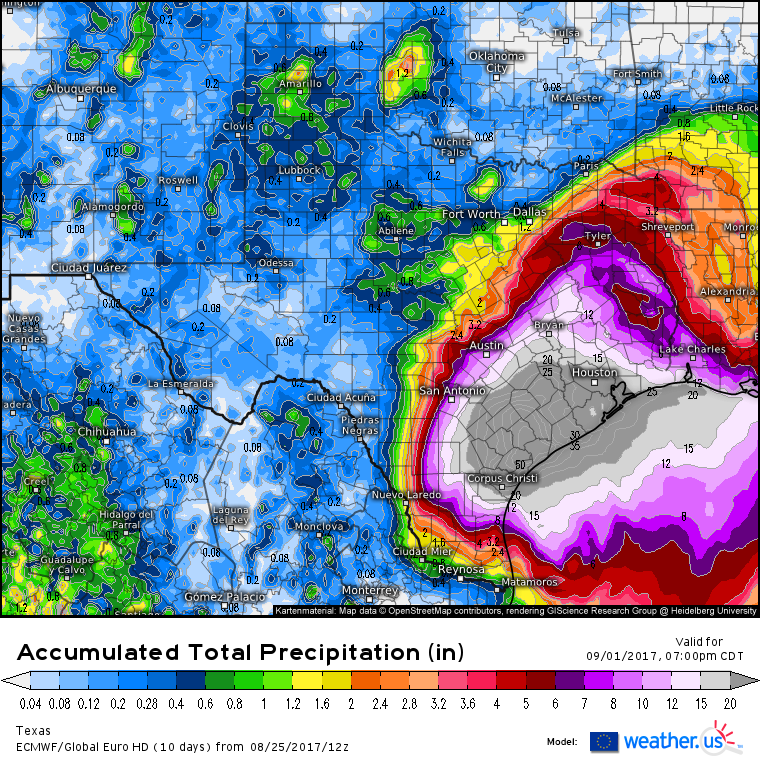
The latest ECMWF run, available in full resolution for free on weather.us, shows potential for feet of rain as Harvey lazily drifts around SE Texas. The magnitude of the flooding disaster here can’t be overstated. Click the links above to explore some of the model rainfall forecasts for the storm. Use the menus to the left of the image to change the zoom as well as select different parameters.
Rain is already in progress across the region and it likely won’t let up until the middle of next week.
Why is it going to rain for so long? After making landfall tonight, the storm will stall and complete a little loop north of Corpus Christi before it moves slowly southeast, back over water. This whole process, landfall, loop/stall, retrograde east, will take several days. During those several days it will be pouring across a wide swath of SE TX. It likely won’t be until the middle or later parts of next week that the storm finally moves away from the Corpus Christi area.
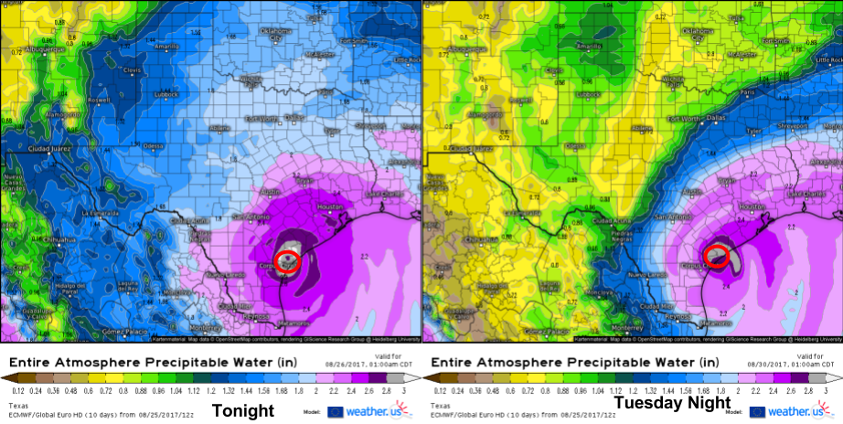
Latest model guidance continues to hint at the potential for the storm to re-intensify as it moves back out over the Gulf of Mexico in the middle of next week. The 12Z ECMWF forecasts a second landfall just a few miles from the first.
The above image is a parameter newly added to weather.us known as Precipitable Water. It’s a measure of how much moisture there is in the atmosphere. Moisture is maximized at the center of a tropical cyclone which makes this a useful tool for tracking Harvey. The two maps shown are the ECMWF’s forecast for tonight (on the left) and Tuesday night (on the right). Notice how it has Harvey making landfall in the same location both nights. While the second landfall likely won’t be as strong as the one tonight, it will certainly post big problems as it will impact areas already devastated from tonight’s events.
Given the complicated nature of the forecast, the details of the second landfall have yet to be worked out. I’ll have much more information about it as we get closer. For now, all eyes are on the storm tonight as it makes its way towards shore.
As the storm bears down on Texas tonight, there are several ways you can track the storm yourself. First of all, check out GOES-16 satellite loops which will show you where the storm is and how fast it’s moving. You can also get a sense for how strong the storm is by watching how organized it is. The storm looks fairly good now, but as it moves over land it will weaken. Thunderstorm activity won’t be as intense, and the eye will disappear. As the sun sets, the visible satellite won’t be available anymore. At that point, use the menus to the left of the image to select a different view that doesn’t need the sun’s light to produce its image. One of my favorites is the Top Alert view which shows you how cold the cloud tops are. The colder the cloud top, the higher in the atmosphere that cloud extends, the stronger the storm producing that cloud is.
Another valuable tool will be our HD radar. Watch the storm’s eye move ashore and track each spiral band as it rotates around the center. The link above is for the HD radar for Corpus Christi. For a regional overview, click the small blue button at the top of the image titled “SD” to see a lower resolution view of the entire system, from Mexico to Louisiana.
You also may be interested in watching the observations from weather stations in the area. We display all the parameters available for each station including temperature, wind speed, wind gusts, wind direction, and precipitation data. All of those will be things to keep an eye on as the system continues to impact Texas through next week. As with all of our data, you can use the menus to the left of the image to explore all the available options in terms of observation time and parameter.
I’ll have more updates this evening and tomorrow as the storm continues on!
-Jack


