Major Coastal Storm To Bring High Winds And Heavy Rain To The Northeast Sunday Into Monday
Hello everyone!
Today’s afternoon update will be a deep dive into the upcoming coastal storm that is forecast to impact the Northeast tomorrow. One of the elements of the storm, Tropical Storm Philippe, is already bringing gusty winds, heavy rains, and severe storms to Florida this afternoon. In this post, I’ll discuss the full forecast, including timing and impacts, as well as point you to some of the resources we have at weather.us to help you stay ahead of the storm. With that in mind, let’s begin!
Overview/TS Philippe
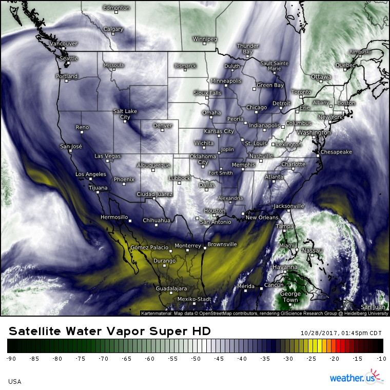
As always, our first stop is with GOES-16 water vapor satellite imagery (what’s that?). This map shows all of our players on the field so to speak this afternoon. TS Philippe is located near the Southern coast of Cuba, while a cold front is draped from Northeastern Mexico up into Northeastern Canada. Along that front, a strong upper level disturbance is located across Arkansas and is moving SE to join up with TS Philippe. Before we dig into the impacts from that upper level disturbance, let’s take a minute to discuss TS Philippe, it’s current condition, impacts, and forecast.
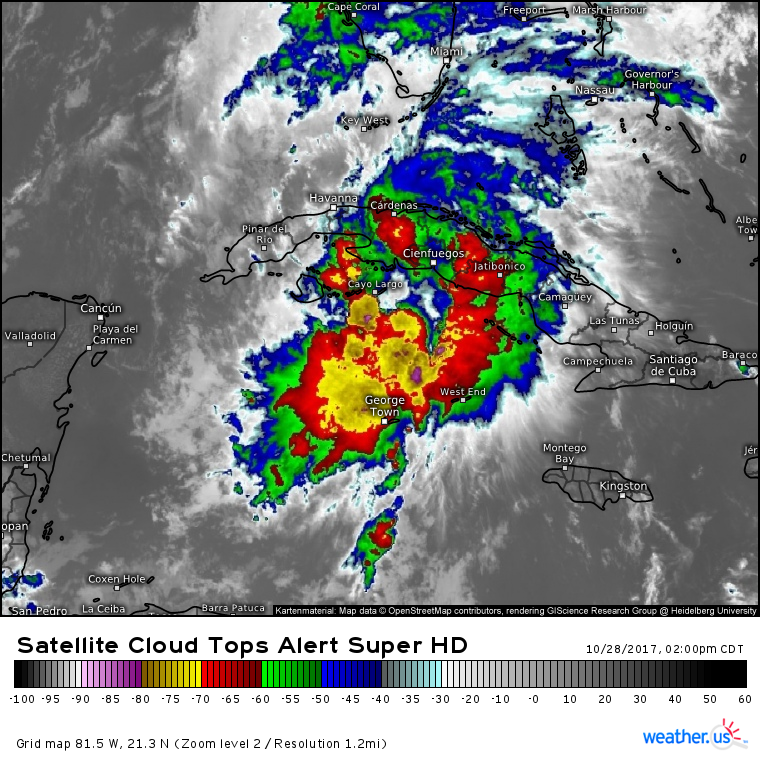
GOES-16 cloud top IR imagery (what’s that?) shows TS Philippe approaching the Southern coast of Cuba this afternoon. The system has excellent outflow in all directions as shear from the upper level disturbance over AR has yet to make it that far south. Strong thunderstorm activity is noted over the center of the storm with a large area of cloud tops below -70C and a few towers down to -80C. Fortunately for the Northeast US, the system is about to make landfall in Cuba which will help to slow development tonight.
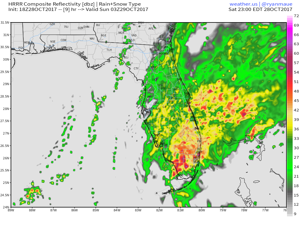
Philippe will move north tonight, ending up off the SE Florida coast. Heavy rain, gusty winds, and severe thunderstorm activity will continue across Florida this afternoon and into tonight as the system moves by offshore. There’s a small disturbance located to the north of Philippe that could help enhance thunderstorms over Southern Florida tonight, even if the center of the named tropical doesn’t make landfall. If you see a swirl on our HD radar products that’s too far NW to be Philippe itself, it’s probably that disturbance! Keep an eye on it, because it will become a very important player in the Northeast by tomorrow evening.
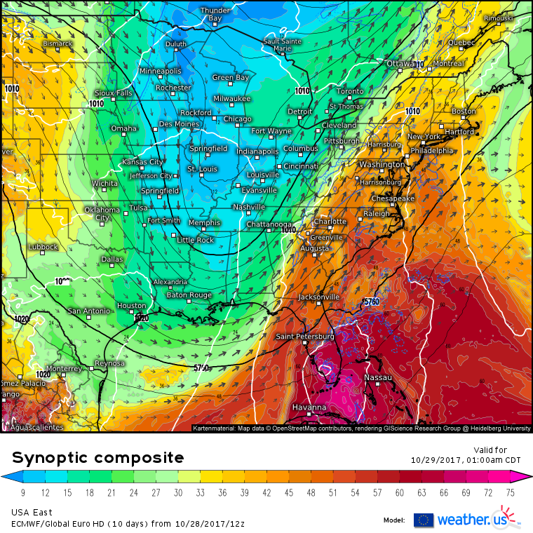
ECMWF forecasts for tonight actually show that northwestern disturbance becoming dominant, with the lowest pressures found across SW Florida. This, if it happens, will be very important, because it would allow for the tropical dynamics of TD-18 to get sucked up into the developing storm. If the southeastern center (currently designated TD-18) is dominant, than the tropical energy from the whole system could very well get booted out to sea. Whether or not TD-18 (soon to be designated TS Philippe) gets pulled up into the main storm, or shunted offshore, will play a very big role in determining how much of an enhancement it will be able to bring to the wind and rain in the Northeast.
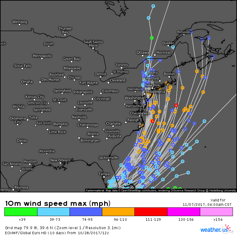
These are the track forecasts for Philippe from the ECMWF ensembles (how do I use this map?). Notice the very wide spread in possible tracks for the system, ranging from Bermuda to Philadelphia. Keep in mind that this forecast isn’t for 5 or 7 days from now, it’s for tomorrow! The disagreement among the models is stemming from their inability to accurately resolve this NW lobe. The models have had days of observations to show them what’s going on with the larger scale circulation of Philippe, including its southeasterly center. The NW lobe, however, is primarily composed of thunderstorms that the models can’t “see” very well. It also hasn’t been around for very long. Based on this, along with the dramatic NW shift in high resolution models that are picking up on the lobe today, I have reasonably high confidence that much of Philippe’s energy will be able to make it into the main storm. Philippe may even remain intact and strengthen as it races towards New England.
Enough about the tropics, let’s discuss the main storm now, because it will be quite the show all by itself, even without its tropical sidekick.
Forecasts show an extremely strong jet streak developing across the Appalachians tomorrow afternoon. This jet streak is anticyclonically curved, meaning that we look to the right hand side of its entrance region for some very strong rising motion. It is in that right entrance region off the Carolina coast that the storm will rapidly intensify tomorrow afternoon. Philippe’s circulation is barely visible in the map above, located due south of Cape Hatteras and due east of Cape Canaveral. You can see how it’s right on the bubble between getting sucked north into the jet, or being flung east out into the Atlantic. Which center can develop faster will be key in figuring out how much energy can be deposited into the developing storm. It is important to note, however, that these jet dynamics will set the scene up in such a way that even if the SE center of Philippe dominates and very little of that tropical energy makes it into the low, we’re still going to be looking at a lot of rain and wind for the Northeast.
Timing
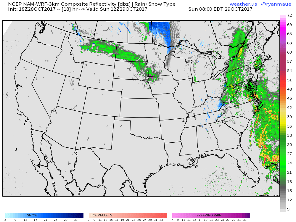
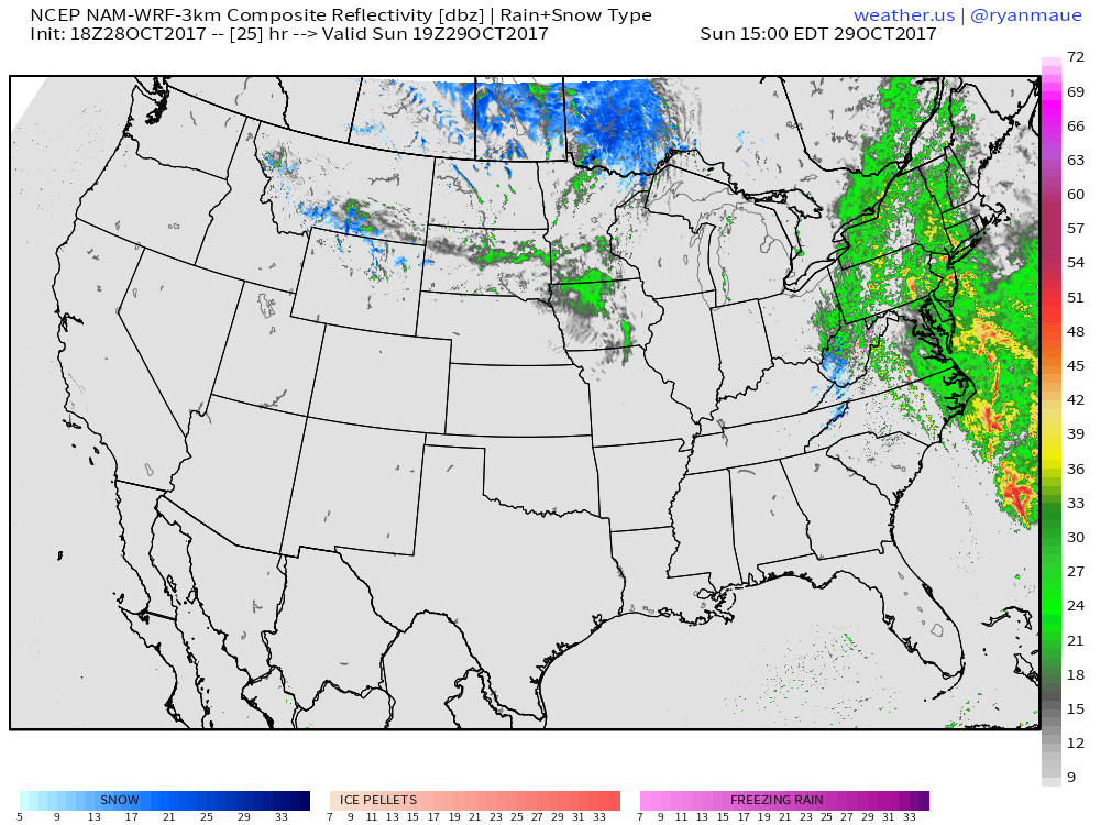
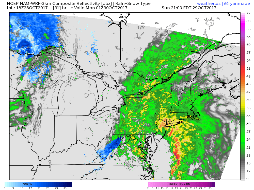
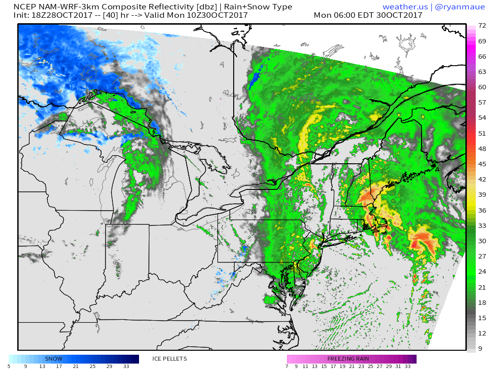
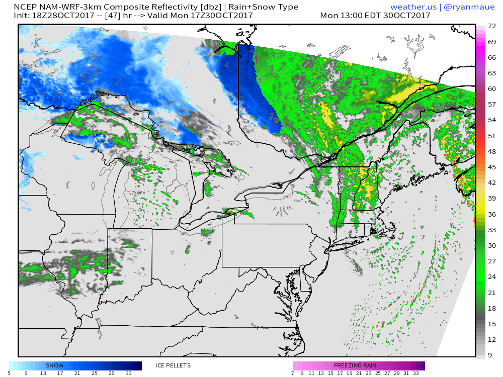
So what’s the timing for this whole mess? I’m going to use the high resolution NAM model to go over start times, end times, and when the worst of the conditions will be for a few different areas. I’ll discuss some of the meteorology behind these impacts below, as well as their magnitude and extent.
By tomorrow morning, our storm still won’t be too impressive. Philippe’s centers will be battling for power and influence east of Florida, showers and thunderstorms will be streaming north into eastern NC and the Chesapeake Bay region, and the cold front that brought showers today will be slowly marching east, with snow showers developing in Kentucky and Tennessee. If you have any outdoor plans tomorrow in the Northeast, it will be best to get them done shortly after sunrise if possible as rain will be developing throughout the morning. Overall impacts will be low tomorrow morning.
Impacts will be increasing by tomorrow afternoon. As the storm develops offshore and Philippe’s energy gets swept into it, rain will increase in coverage and intensity across the Northeast and Mid Atlantic. Winds will also be on the upswing. Meanwhile, notice the mixed precipitation and snow developing in West Virginia. Winter isn’t too far away! If you still haven’t secured loose objects outside, or made preparations for power outages along the New England coast, you should wrap those up before the sun goes down tomorrow evening. Overall impacts tomorrow afternoon will be moderate.
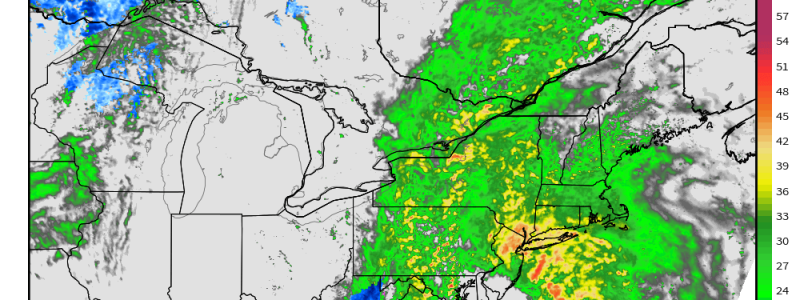
Late Sunday evening will be the worst of the storm in the NYC area. The low will be rapidly developing offshore, and Philippe’s moisture and energy will be funneling into the east side of the system. A line of very heavy showers and potentially even thunderstorms will develop along the cold front. This core of heavy precipitation will also feature the core of the winds, which I’ll talk about in the impacts section below. As moisture wraps into the back side of the system, heavy rain will redevelop in the Mid Atlantic, including Washington DC. Meanwhile, snow will be continuing to fall in West Virginia though not too much in the way of accumulation is expected. With torrential downpours and high winds expected in NYC, impacts Sunday evening/night are expected to be high!
By Monday morning, New York City will see the main storm move overhead, with a break in the rain and lighter winds. Heavy rain will continue upstate, as well as in New England. The kink in the line of heavy precip SE of Cape Cod is what will be left of Tropical Storm Philippe by Monday morning. This will be the time of peak winds and rain in Boston, Portland, and the rest of Eastern New England outside of NE Maine. With hurricane force wind gusts possible on Cape Cod along with thunderstorms and torrential rains, impacts Monday morning will be high!
By Monday afternoon, the heavy precip will wrap up as showers develop underneath the upper level low. Gusty westerly winds will usher in drier air and sunshine will develop from SW to NE. Impacts Monday afternoon will be low.
I’ve only taken a few of the many images available to show you snapshots of what the timing will look like for this storm. To see hour by hour simulated radar and other forecasts, you can go to Dr. Ryan Maue’s site wx.graphics or to weather.us.
Impacts
So who will see the worst impacts from this storm, and how bad will it get? Impacts will be split by the track of the storm itself. Those east of the low will see strong winds, capable of doing some damage to trees and power lines. Those west of the low will see several inches of rainfall that could cause some minor flooding concerns. Let’s start with the wind.
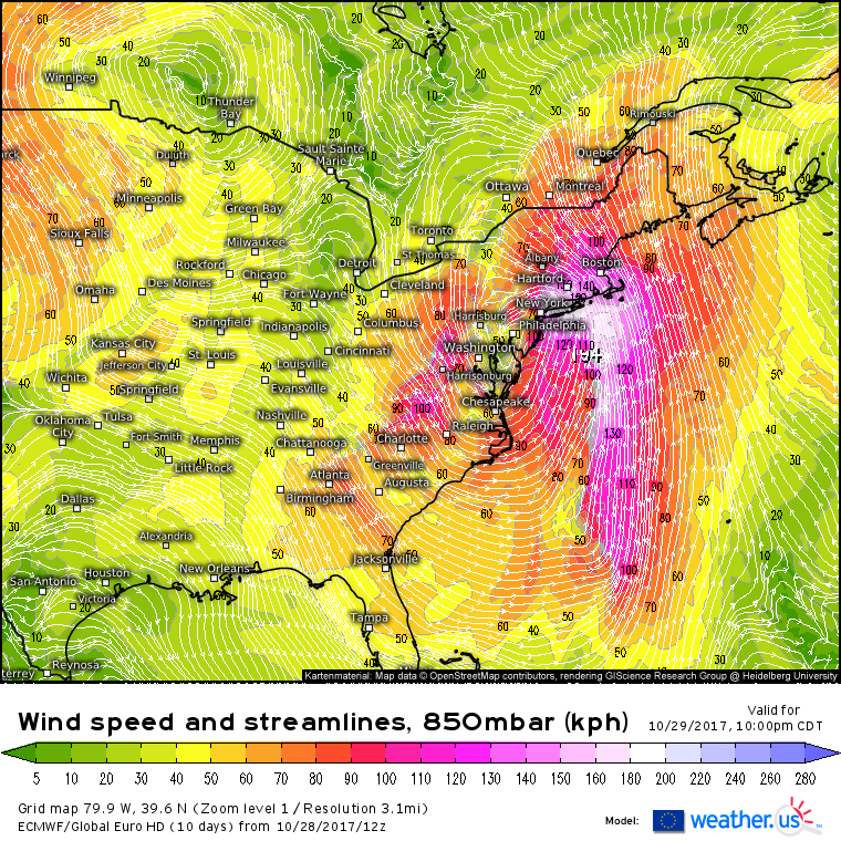
The upper level jet dynamics I discussed above will lead to the formation of a strong low level jet as air rushes towards the Northeast to fill the void left by rapidly rising air at the center of the low pressure system. This low level jet will be extremely powerful, and winds of 100-120 mph are forecast just 5,000 feet above the surface. While these winds won’t make it to the surface, small portions of the LLJ can be transported downward through a process known as momentum transfer which happens in heavy precip. Given the forecast heavy precip, and extremely high winds just off the surface, some very impressive wind gusts are being forecast for Sunday night into Monday morning.
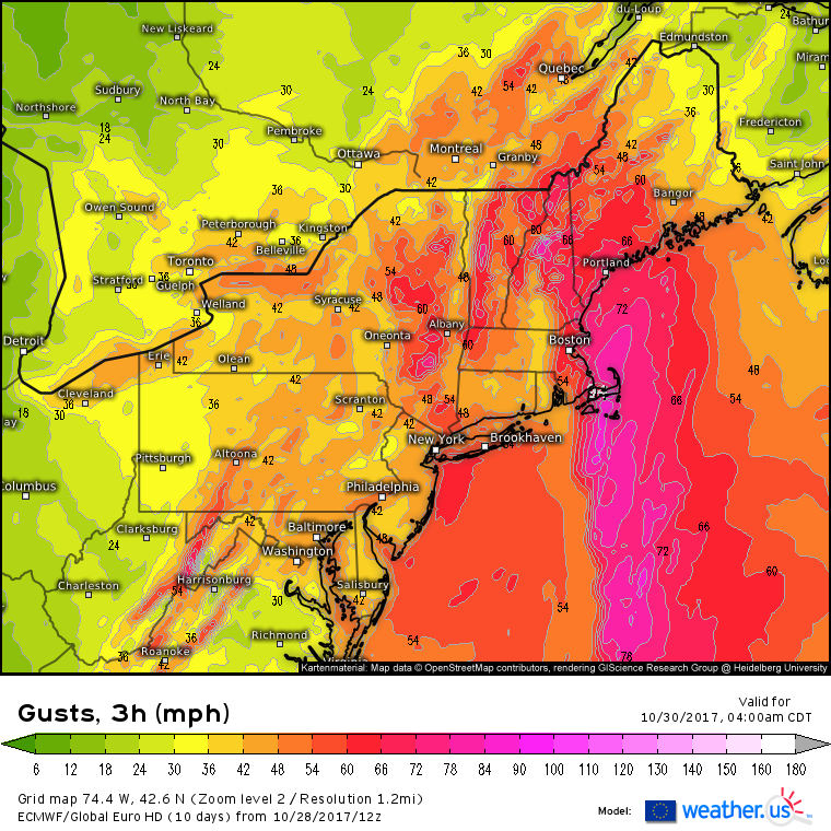
This ECMWF wind gust forecast does a pretty good job of highlighting who will see the highest winds. I think some of its numbers may be a little high, especially ahead of the front in ME, MA, and NH, but it does a good job of showing some important trends. Notice that there are two distinct areas of especially high winds: ahead of the front, and behind the front. The winds ahead of the front will be the strongest, gusting near hurricane force along the New England coastline. They will be out of the SSE, and due to warm air rushing in faster aloft than at the surface (remember winds are faster aloft than at the surface), there will be a bit of a temperature inversion which will help prevent some of those strong LLJ winds from mixing down to the surface. Behind the front, the sun will come out and the atmosphere will begin mixing as winds turn westerly. This mixing will help strong winds aloft move down towards the surface. As a result, gusty winds are also expected, and for inland areas, these westerly winds are likely to be even stronger than the prefrontal southeasterlies. Winds will die down Monday night as the storm moves north into Canada.
What about the rain?
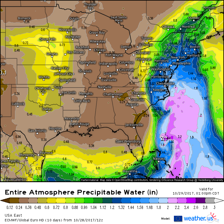
Tropical moisture will be surging north into this system as it develops tomorrow. Tropical Storm Philippe will help with this process, and you can clearly see the local moisture max near the center of the storm tomorrow afternoon. The large river of moisture extends much farther north, and is pointed just a little west of the low track, towards the Mid Atlantic. This is where we’ll find the heaviest rain.
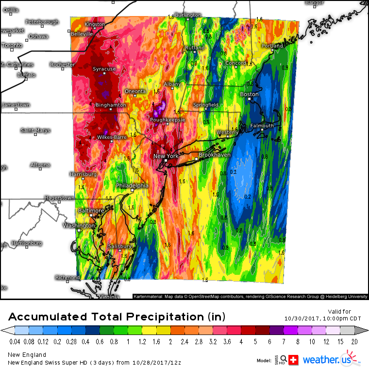
The Swiss Super HD model has a high enough resolution to pick up on a few key features here regarding the precipitation forecast. First, notice the difference in rainfall distribution west of the low in upstate NY and PA, and east of the low across New England. There’s a wide swath of heavy rainfall forecast west of the low, while the rain east of the low is oriented in streaks that are dependent on the track of individual shower/thunderstorm cores. Some folks in Eastern Mass might be lucky to pick up a quarter inch of rain, while the next town over could see over 2″. In NY and PA, it’s a pretty safe bet that areas like Syracuse, Binghamton, Wilkes-Barre, and Poughkeepsie will see several inches of rain. Locally higher amounts will be found on the Eastern slopes of the Catskills where upsloping will enhance rainfall, and locally lower amounts will be found west and northwest of the Catskills where downsloping will detract from rainfall dynamics. You can also spot upslope/downslope signatures in the White Mountains of New Hampshire.
Given last week’s rainfall, some areas might be prone to some flooding from this storm, but rivers are still fairly low and soils still fairly dry after several months of near-drought, so no widespread flooding is expected. However, areas that receive lots of rainfall in a short period of time will be at risk for flooding, despite the relatively low risk overall. There’s a reason that the NWS has put out a flash flood watch for much of the Northeast instead of a flood watch. It’s the short fuse rain rate driven flooding that will be a concern with this system, not the overall larger scale issues.
The storm wraps up Monday night with drier and much calmer weather returning for the middle of the week.
Hopefully by now you understand the storm, what’s driving it, what its impacts will be, and why the storm is forecast to behave as I have described. With that knowledge in mind, you’ll be extra prepared to watch it all unfold tomorrow on GOES-16 satellite imagery, HD radar imagery, high resolution modelling, and current station observations. All of these links are to maps that you can zoom in on by clicking. You can go all the way to county level if you want to!
I’ll have more information both here and on Twitter tomorrow!
-Jack
