Laura Rapidly Intensifying Into A Major Hurricane This Morning, Landfall Expected Tonight Near The TX/LA Border
Hello everyone!
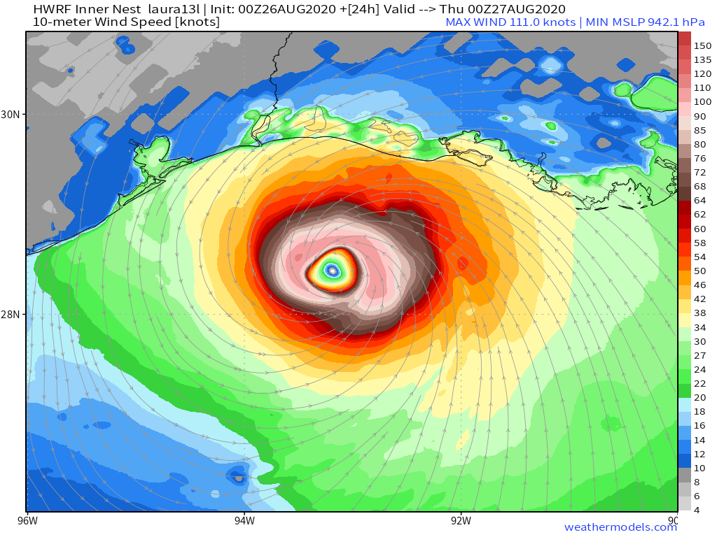
Laura continues to rapidly intensify in the Gulf of Mexico this morning and is well on its way to becoming an extremely dangerous Category Four hurricane by tonight. Overall, not a ton has changed regarding the system’s overall forecast besides increased confidence in a higher intensity at/near landfall. This post won’t repeat what was said yesterday about the expected impacts in SE TX/SW LA, but will focus on a couple interesting aspects of Laura’s evolution meteorologically-speaking. The three main topics of discussion in this post will be why hurricanes like Laura wobble while moving forward, what an eyewall replacement cycle is and what one means for impacts in TX/LA, and whether a little bit of wind shear might cause some last-minute weakening before Laura makes landfall tonight.
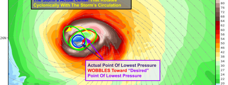
 What started as a hasty tweet yesterday afternoon warning about drawing conclusions from hourly track trends in Laura’s center turned into a recurring series tracking Laura’s every move. This has been dubbed the “wobble plot” because it shows the wobbles in Laura’s center each hour on top of the most recent EPS forecast for the storm’s overall track. Note that there is a little bit of guesswork involved here because we don’t have hurricane hunter fixes every hour, so I have to estimate the center location from satellite imagery and the most recent hurricane hunter data. Perhaps if you squinted at the same maps, you might come up with a slightly different center fix for a few frames. But nevertheless, this is pretty close, and gives you a good idea that while Laura’s overall motion is towards the northwest, there are wobbles both north and west that, if extrapolated until landfall, could give you some pretty wild ideas about where the storm might be in 24 hours. If you were to assume the northward wobbles would continue, you’d expect to see the storm in eastern LA by tomorrow. If you extrapolated the westward wobbles, you’d think the storm was going to Brownsville Texas. Neither of those predictions would be very accurate, and we’re still focused on the TX/LA border region as the most likely place for Laura’s center to come ashore.
That said, there has been a consistent (>6hrs) trend towards Laura sliding a hair N/E of forecast points last night. I suspect we’ll see the ongoing westerly wobble correct that a bit, but nonetheless this gives some extra credibility to recent model guidance showing a track just east of Houston rather than over or just west of Houston.
So why is Laura wobbling like this?
The short answer is that Laura’s circulation isn’t perfectly circular yet, and any spinning ellipse will follow a wobbly path. The ellipse is anchored by the storm’s actual center (lowest pressure), and that point of lowest pressure “wants” to be at the center of the ellipse. So when the vortex elongates to the northeast of the true center, the center will wobble to chase the vortex ellipse northeast. That’s what happens when we get a huge burst of thunderstorms northeast of the center followed by a northward wobble. The westward wobbles happen when a big burst of thunderstorms blows up southwest of the center and the true center chases the ellipse southwest. Also remember that the motion we observe on satellite imagery is a combination of these wobbles and the prevailing storm motion (governed by the environmental steering flow). So the wobble northeast + prevailing storm motion towards the NW = observed track wobble due north.
 As Laura continues to intensify and approach the coastline, its vortex will become more circular. This will make the storm less wobbly, though smaller-scale mesovortices will continue to temporarily tug the center a little east or west of the prevailing track. These wobbles are called “trochoidal wobbles” and arise due to instability in the intense vortex of a powerful hurricane. So while the wobbles will settle down a bit today, they won’t go away entirely.
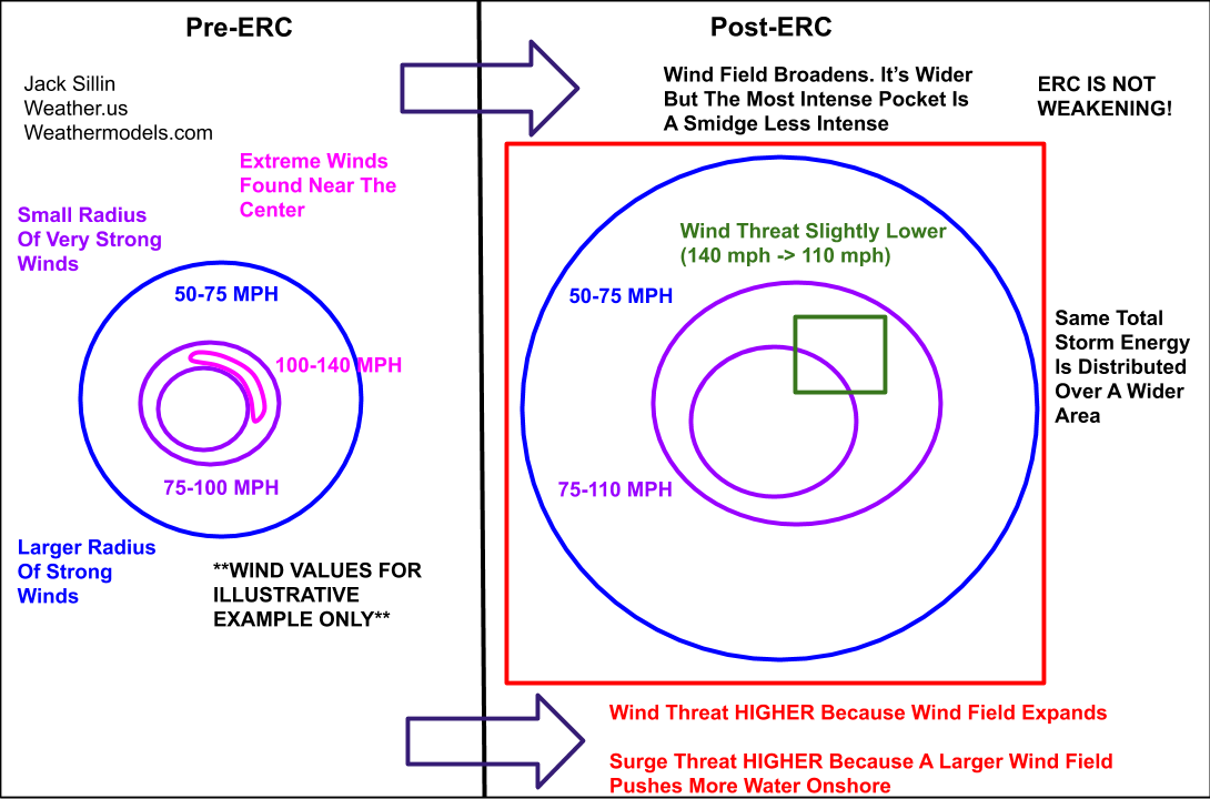
Another process to keep an eye on today will be the possibility of an eyewall replacement cycle (ERC or EWRC for short). These occur when the thunderstorms just outside the hurricane’s eyewall get strong enough to rob the eyewall of fuel. The inner eyewall then collapses and a new eyewall takes shape from those new thunderstorms. ERCs are very common in strong hurricanes. It would be quite rare if one didn’t happen! The only question about Laura’s ability to undergo an ERC is how much time it has left over water. Usually the inner eyewall can last a day or two, and this one has only been around for 6-12 hours with another ~18 hours to go before landfall. So it’s not a guarantee that Laura will have time for an ERC.
What would happen if an ERC were to occur? The storm’s maximum sustained winds would come down a little bit (5-10 mph) but the radius of maximum winds would expand. This can be confusing as you see headlines that say “Laura weakens!” or “Laura is downgraded!”. While those headlines are perhaps factually true, they are misleading because they imply that the storm has lost strength. It hasn’t! While the wind threat in the 15 or 20 miles northeast of the center may have come down slightly, the overall wind threat from the system increases post-ERC because the wind field expands and more locations are impacted by strong winds. Perhaps more importantly, the storm surge threat increases significantly because a larger wind field pushes much more water onshore. So even if you see Laura’s maximum winds come down a tad this afternoon due to an ERC, recognize that doesn’t mean the storm is weakening!
Does that mean the storm can’t weaken before landfall?
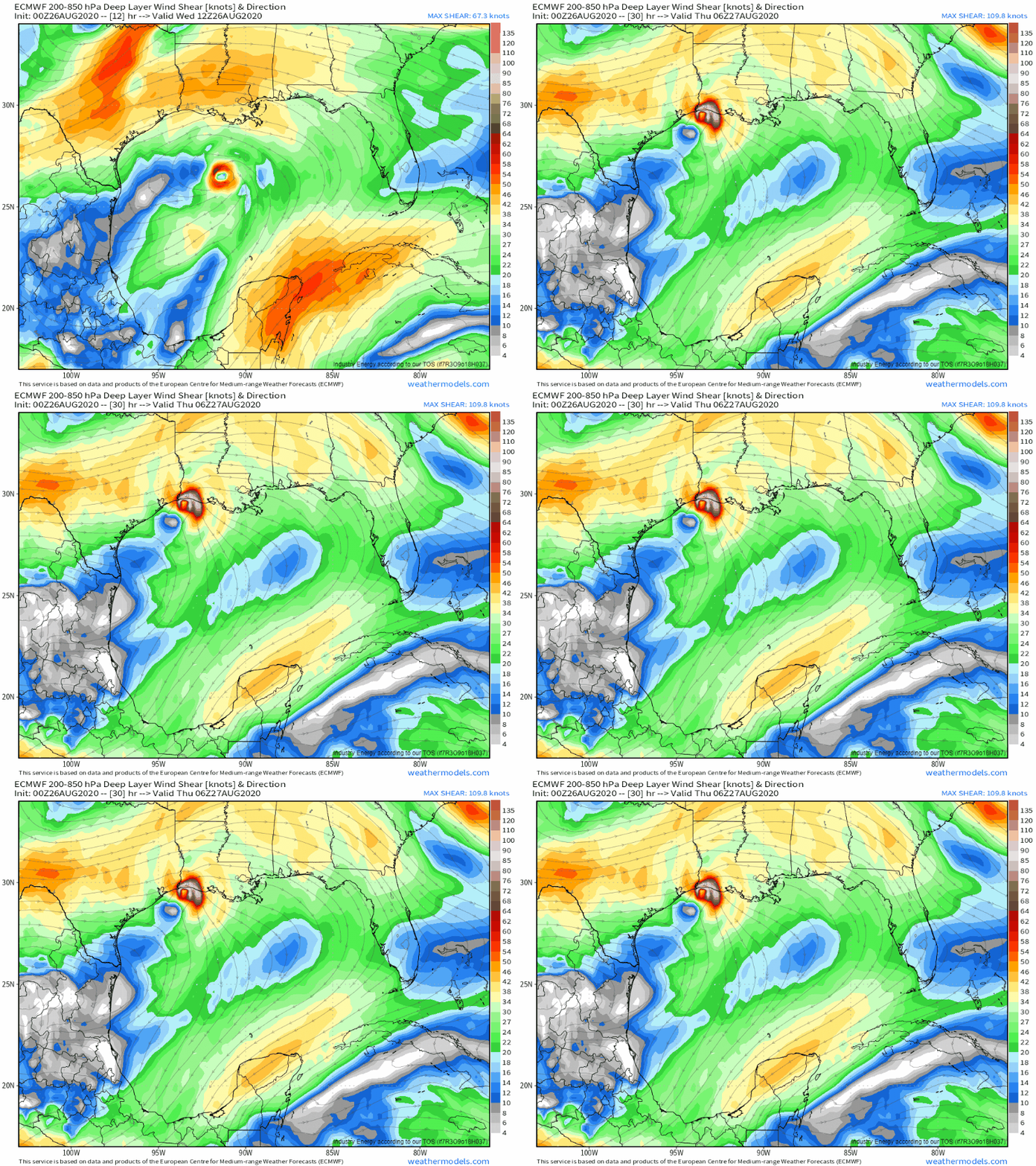
 I think the prospect of Laura weakening enough to make a substantial difference in the outcome for SE TX/SW LA is very unlikely. But the storm could be disrupted at the last second by a slight increase in westerly shear ahead of a trough over Texas. Note that shear over Laura increases from almost nothing this morning to 20-30 kts (that might be a little bullish) by tonight. With such a powerful inner core and enough latent heat release to bully that trough a bit, I don’t see Laura weakening rapidly leading up to landfall. But hopefully just enough shear can arrive to knock a few mph off the winds. Anything helps at this point.
I’ll be tracking the storm all day on twitter @WeatherdotUS and @JackSillin.
-Jack


Again, Jack… You’ve done an exceptional job! Just, wow. Your descriptions, explanations, graphics. It amazes me that COAMPS-TC (reported by Dr. Jeff Masters at YCC as the most accurate for 2019 intensity among 5-day forecast models) absolutely nailed the Cat 4, and very near on track/expected landfall location as well. When Laura was basically an open wave before booming onward to Puerto Rico. HWRF was similarly bullish. I’m certain you invest substantial time into writing your blog pieces, and it really shows! I especially appreciate the details, how you’ve explained the overall energy of ERCs remains the same, trochoidal wobbles and how some may (wrongly) try to discern a track from each and every blip. Your wobble plot is cool, a great visual aid. I’ve recently come to expect the highest standard from your work, you do not disappoint.
While many sites have ‘weather enthusiasts’ who might try to pass themselves off as expert, here you are explaining how Laura might’ve gone slightly south of the Cuba track projected (it did), how more westerly movement would occur if it strengthened (both happened as you’d mentioned and explained), that shear isn’t always a deterrent because it allows great and stable outflow (also occurred), and… many more factors and variables you’ve alluded to. You’ve got the knowledge and wherewithal, but also the humility to not write the dozens of “I told you so’s” but I want to point them out and and have taken notice.
Right now, I’m thinking Cornell is as lucky to have you as you them. Just pleasepleaseplease don’t ever go work for the evil empire of AccuWeather. Stay vigilant and safe everybody, this is set up to be an absolutely devastating event.
Thank you so much for these kind words! I’m honored and humbled to hear that my explanations and forecasts have been useful and interesting 🙂 take care and stay safe
Jack
Ah, I’m in Saipan, CNMI. Other side o’ the world. But trying to get through the next 11-12 weeks of typhoon season unscathed, ya know? I wish Laura would fall down a manhole or into an open seafloor vent or something. Best thoughts with everybody right now. Cheers.