Large Storm Taking Shape Today In The Southern Plains
Hello everyone!
Yesterday’s blog focused on a longer period wet pattern with sizeable impacts for parts of the Lower MS/Ohio Valley areas, and is still a relevant read if you haven’t already. This morning’s blog will focus on one of the storm systems contributing to that wet pattern, and what to expect from its more wintry aspects. Two areas are expecting substantial wintry weather from this system: the Midwest, and the Mid Atlantic. As has happened several times this winter, DC is expecting more snow than Boston and New York City combined. 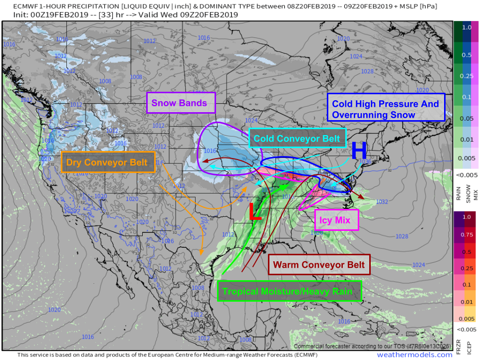
The ECMWF’s precipitation type forecast for early tomorrow morning does a great job highlighting the various dynamics of a mid latitude cyclone. I’ve marked out with smaller arrows the three primary “Conveyor Belts” of the system. These work exactly like a conveyor belt you might see unloading your baggage at the airport. It’s a current of air that allows similar parcels of air to follow a common path. For example, the warm conveyor belt brings warm moist air from the Gulf of Mexico and funnels it northward. As it moves north, it also rises which results in precipitation. Once it passes over the storm’s warm front, it splits in two. One branch heads west to Iowa while the other turns east to DC. Under the WCB is the CCB (Cold Conveyor Belt), which will supply cold air near the ground to both Iowa and DC. That cold air will be sourced from a strong high pressure system over New York, and will enable heavy snow to fall in both locations, as well as a fairly expansive swath in between. Map via weathermodels.com.
Of course there are many more dynamical processes at play here, and many of them are better visualized with tools such as the ECMWF’s Synoptic Composite map at weather.us, but the three conveyor belts are always a great place to start when looking at mid latitude cyclones like this.
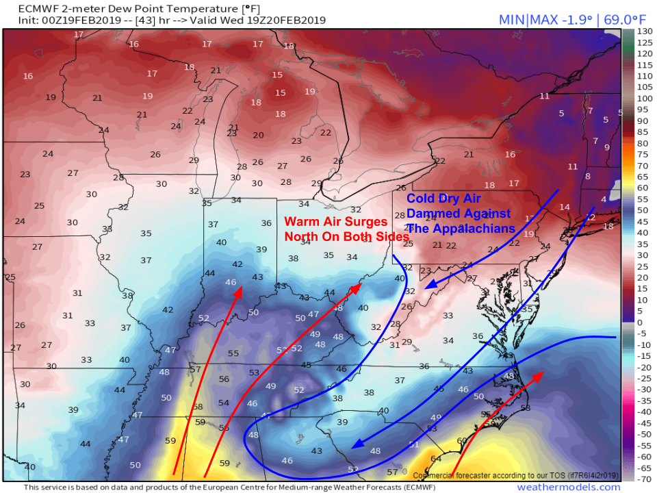
Here’s a look at forecast dew points tomorrow afternoon. I find dew points to be a good proxy for temperature in situations like this, because the threshold for wintry precipitation is usually closer to the dew point = 32F mark as opposed to the temperature = 32F mark. The reason for that has to do with latent heat processes associated with evaporation. Evaporation takes heat out of the air surrounding the water molecule that is evaporating, which thus cools the air down to near the dew point (a process known as wet bulbing). Thus if you have dew points below freezing, you need to watch out for freezing precip even if temps are a few degrees above freezing. The dew point plot also highlights the contrast in airmass between warm/moist air in coastal parts of the Carolinas/the Ohio Valley and cold dry air draining south just east of the Appalachians. This cold air damming will set up the threat for wintry precip in the Mid Atlantic tomorrow. Map via weathermodels.com.
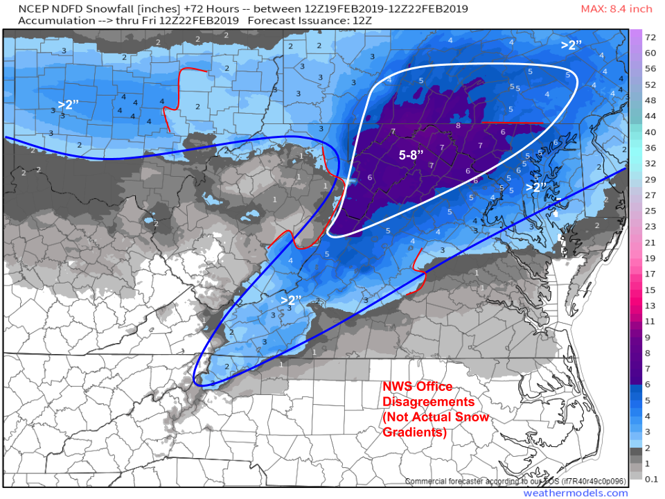
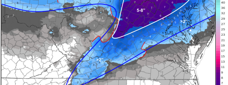
Here’s a look at how much snow the NWS expects to fall across the Mid Atlantic during this storm. Note that this map is a compilation of each local forecast office’s forecast, so sometimes artificially high gradients are created along forecast office boundaries. For example, NWS Baltimore/Washington’s forecast area ends in NE WV, and they are forecasting much higher totals than NWS Charleston which covers adjacent parts of central/eastern WV. A fairly sharp gradient will occur along the spine of the Appalachians, but the map makes that seem much more extreme than it actually will be. Map via weathermodels.com.
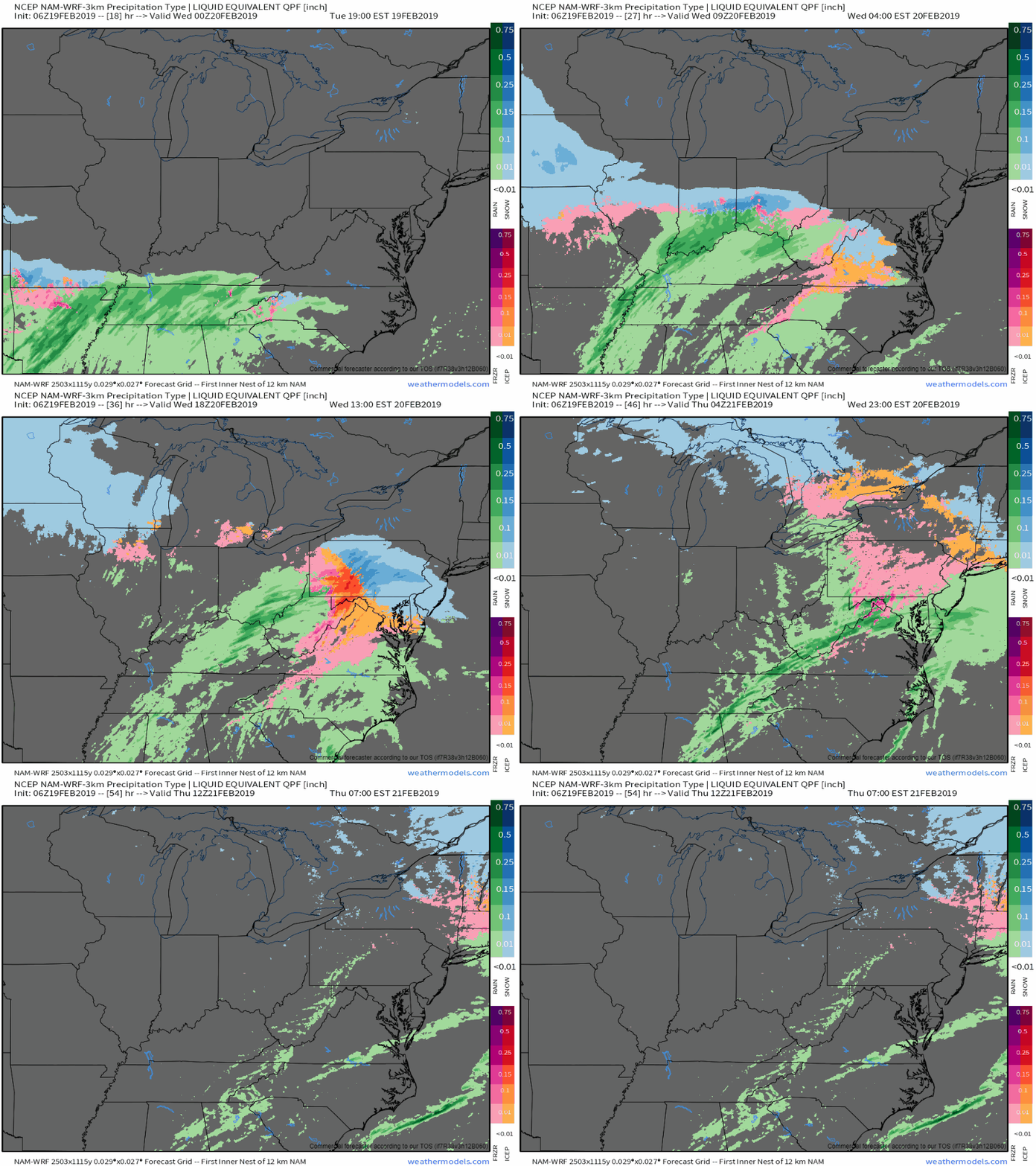
Here’s a look at how precip types will evolve with this storm over the next few days. The system starts snowy as far south as the VA/NC border tonight, but a change to sleet/freezing rain quickly progresses from SW to NE as warm air moves in aloft (remember the warm conveyor belt discussed above, and the fact that the cold air supply is fairly confined to lower levels). Freezing rain will struggle to plain rain as low level cold air remains locked in place especially near the mountains of VA/NC. Farther north, very little if any plain rain is forecast for central parts of PA and upstate NY. Ice totals shouldn’t be too high, and no widespread power outage issues are expected due to ice accretion, but remember it only takes a very thin glaze to cause major travel problems! Precip wraps up quickly tomorrow night. GIF via weathermodels.com.
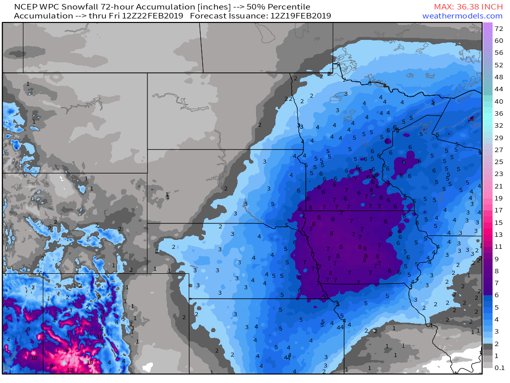
Up in the Midwest, the storm system will be less dynamically interesting as light/moderate snow falls on the NW side of what will end up being a fairly weak area of low pressure. Snowfall guidance from the WPC indicates a general 3-6″ snowfall from Kansas up through Wisconsin. Amounts a little over 6″ are possible mainly in Iowa and southern MN. Because of the progressive (fast-moving) pattern, the branch of the warm conveyor belt that has to turn upwind (west) to bring moisture to this area will be substantially weaker than the branch moving moisture towards the Mid Atlantic, and thus we’re not expecting all that much snow. That said, even a 6″ event is worth taking seriously if you need to travel. Allow plenty of extra time and take it slow. Map via weathermodels.com.
-Jack
