Large Storm System To Bring Wintry Precipitation To A Wide Swath Of The Northeast And Mid Atlantic
Hello everyone!
It’s been quite the active start to the week weather wise! Much of that activity has been focused in the Southeast where widespread severe weather has been causing major problems from Mississippi yesterday to Florida today. The storm system behind those storms is moving northeast this afternoon, and will be responsible for some significant winter weather in the Mid Atlantic and Northeast, the first round of which is already underway. Snow will be this storm’s main impact, with falling snow reducing visibility, and accumulations expected to result in slick travel. The secondary concern will be power outages as already-weakened trees are weighed down as northerly/northeasterly breezes develop. Coastal flooding is possible as well, though won’t be nearly as severe as that experienced with some of the storms earlier this month.
GOES-East Water Vapor satellite imagery (what’s that?) shows an assortment of elements lining up this afternoon to bring wintry weather to the Mid Atlantic and coastal Northeast. The main disturbance that will trigger storm development is now driving east through Mississippi, and is becoming negatively tilted as it moves east. Tropical moisture continues to surge north ahead of the disturbance, and that moisture is fueling some strong thunderstorm activity along a surface cold front moving through Florida. Heat energy from those thunderstorms is boosting the heat reserves of a weak ridge building downstream of the developing storm, thus increasing its strength. This will help guide the storm a little farther to the north, not enough to be a blockbuster for the entire Northeast, but close enough for significant snows in the Mid Atlantic, and a more glancing blow to the Southern New England coastline.
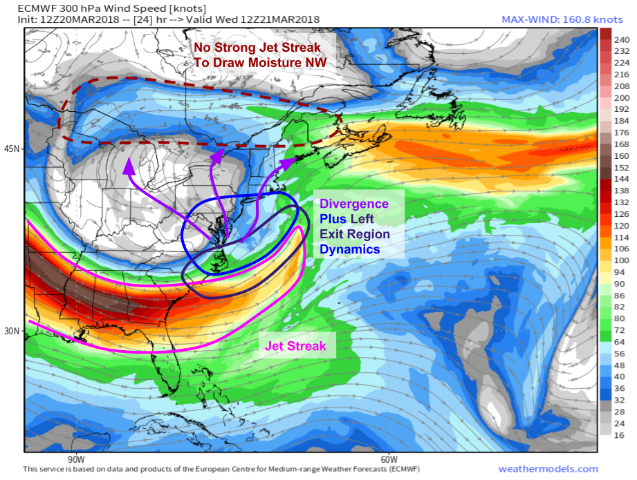
The ECMWF’s jet stream forecast shown above indicates some strong signals for heavy snow, as well as some signals that aren’t quite as favorable. A strong cyclonically curved jet streak is diving into the base of a large trough over the Ohio Valley. The left exit region of this jet is co-located with an area of diverging winds, and the combination of the dynamics associated with both processes will create strong rising motion across eastern parts of the Mid Atlantic, and the adjacent waters of the Atlantic Ocean. However, there’s no strong jet streak to the north to “couple” with the southern jet. The would-be coupled jet partner is well to the east, south of Newfoundland, and isn’t “stacked” to the north of the storm. As a result, it will be hard to get moisture to really push northwest, and the heaviest snows will be found farther south and east than in recent storms. Map via weathermodels.com.
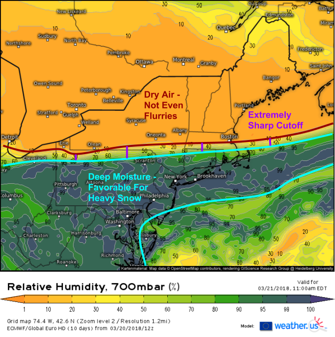
Instead of deep layer moisture transport into the entrance region of a strong jet streak, we instead have an extremely dry airmass entrenched across New England due to high pressure in Quebec, as seen by the ECMWF’s mid level (700mb/10,000ft) RH forecast shown above. This means that there’s going to be a razor-sharp cutoff between deep tropical moisture supportive of heavy snow, and bone dry Canadian air that won’t even let flurries reach the ground. Current forecasts put this cutoff right around the Mass Pike, extending west into the Catskills and towards the NY/PA state line. The forecast for snowfall accumulations is most uncertain in this area, as an adjustment north of south of 20-30 miles will mean the difference between bare ground and 6″+ of snow.
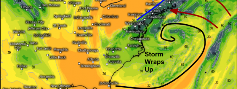
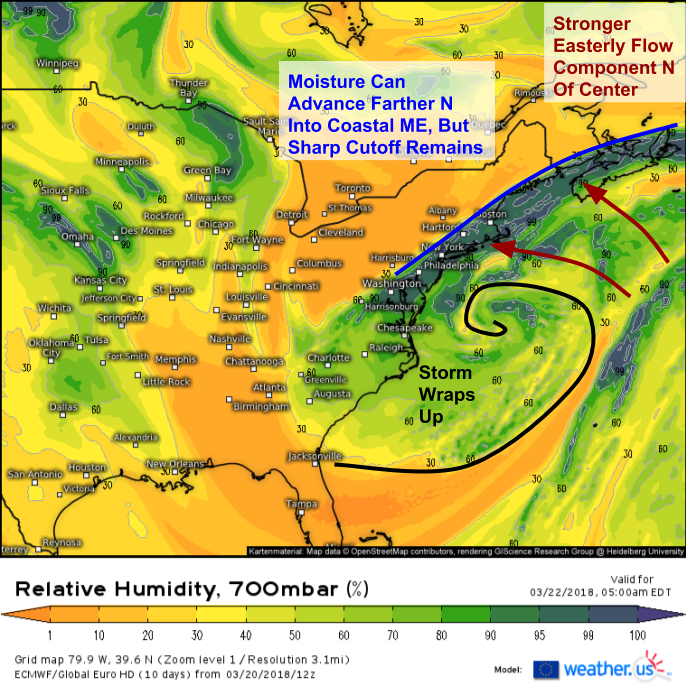
By the time we get to Thursday morning, the storm will have wrapped up a bit off the Mid Atlantic coastline. This wrapping-up process strengthens the easterly component of the wind north of the storm’s center, which means that that the axis of deepest moisture will pivot from an E-W orientation to a NE-SW orientation, eventually transitioning to N-S before moving fully offshore. This means that while dry air will shut off precip in the Mid Atlantic, moisture may make some headway into the dry airmass over Eastern MA, SE NH, and extreme coastal ME. Notice however that the same sharp cutoff we saw earlier in the storm’s life remains fully intact. The forecast uncertainty for this area remains high due to this cutoff feature.
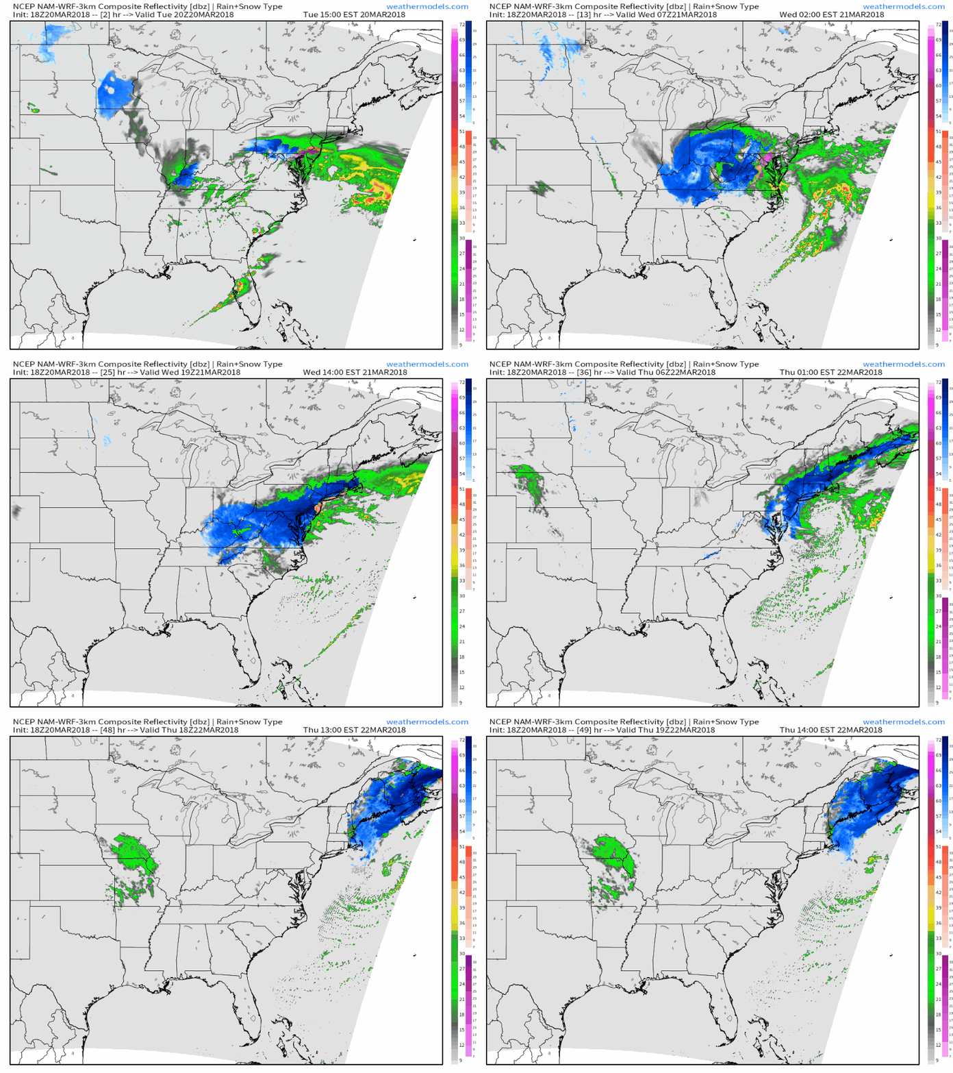
This NAM simulated radar animation ties the forecast together and gives what I think is a good visualization of how things will evolve, even if it gets many of the specifics wrong. It can’t predict the exact location of a snow band tomorrow, nor exactly where the cutoff will set up, nor exactly how much snow will fall in any given area. It also is likely overdoing the convection offshore tonight, which is a known NAM bias. This is likely leading to some erroneous strengthening of the storm, and may result in its placement being forecast farther northwest than its actual position will end up being. However, even with all those flaws, it still presents a good way to visualize the general evolution of the systems, which is as follows. GIF via weathermodels.com.
Today’s “leadoff” system will exit quickly tonight, while the main storm takes shape over the Carolinas. That storm moves offshore and strengthens tomorrow, spreading bands of heavy snow into the Mid Atlantic and coastal parts of the Northeast. As the storm wraps up tomorrow night, snow will spread northeast into places like Boston and coastal Maine, but by that point the storm will begin to weaken, and the intensity of snowfall will begin to wane accordingly. Snow moves out of Eastern New England Thursday afternoon as the system continues to weaken and race east towards the Canadian Maritimes.
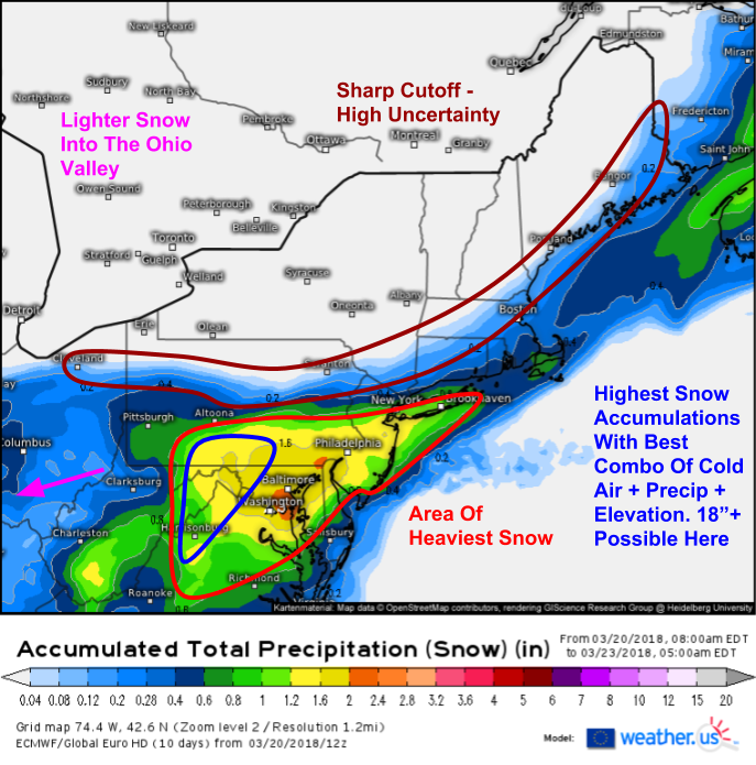
Here’s a look at what to expect as far as accumulation patterns. I haven’t included numbers on this map for a reason, there are just so many factors that go into how much snow actually falls in any given location, and even that is subjective to a certain point. Inside the red circle, expect heavy snow with accumulations ranging from 2-3″ at the southeastern edge of the area to 18″ in the mountains of W VA, WV, and S PA. I’d expect probably between 6 and 10″ from DC to Baltimore to NYC, but that will depend on exactly where the heaviest bands set up and for how long. Check with your local NWS office for snowfall predictions for your town, and beware of any maps that use a generic 10:1 snow ratio, the warm temps and late season nature of this storm will keep ratios below that for most lower elevation areas. This map is the ECMWF’s forecast for liquid equivalent falling as snow, so it does not have a ratio applied to it, making the map more useful in a variable ratio situation. For more on forecasting with QPF(snow) and ratios, check this tutorial out.
Earlier today, I posted analysis of this week’s other significant weather event, an atmospheric river in California set to bring excessive rainfall to the Thomas Fire burn scar which will result in flash flooding and mudslides. Check that out here: https://blog.weather.us/intense-atmospheric-river-event-set-to-begin-across-california-today/
For more forecast information and storm tracking tools such as HD radar https://weather.us/radar-us/usa-east/#play, GOES-East satellite imagery https://weather.us/satellite/usa-east/top-alert-superhd-5min.html#play2, and current observations https://weather.us/observations/usa-east/weather-observation/20180320-2100z.html, head on over to weather.us.
-Jack



I subscribed to weathermodels.com just about a week ago. WOW! What an incredible site! The access to all of the global models and model assembles, and tracking their varying output, is an incredible experience. This is absolutely awesome!