Large Scale Pattern Change Set To Bring Cold And Stormy Weather To The East
Hello everyone!
After a long month of warm and dry conditions, the Eastern third of the country will see a flip to colder and stormier weather, while the pattern will change in the opposite direction for the West Coast. So what’s behind this pattern change, and what impacts will it bring?
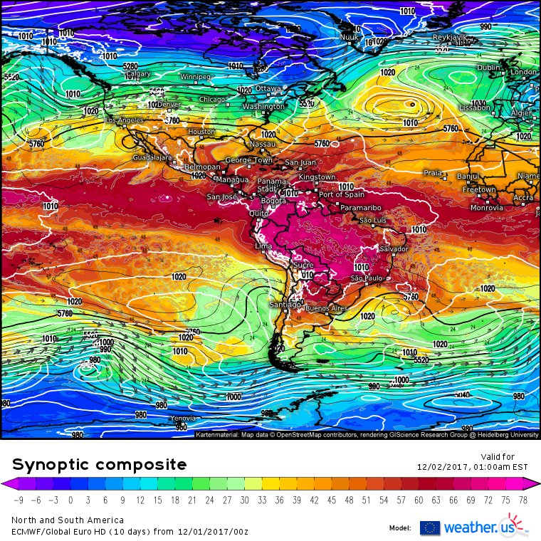
Here’s a look at our current pattern. There are several important features to note. First of all, look at the shading. The shading is a parameter known as theta-e, which is a measure of heat and moisture. The higher the theta e, the warmer and more humid it is, and vice versa. Notice how the colors that appear over the US occupy the middle of the color scale. It’s neither really warm/humid, nor really cold/dry. Our current pattern is characterized by relatively moderate temperatures. All the Arctic air (deep blues and purples) is bottled up in the northern part of Canada, and the tropical air (reds and pinks) sits well to our south in the Caribbean.
Next look at the black lines. These are 500mb height lines. Notice how the lines over the US are almost perfectly straight. Each line enters the west coast at the same latitude as it exits the east coast. This indicates upper level wind flow that is zonal, a fact confirmed by the upper level wind vectors that do indeed point from west to east. Outside of the US, there are a few other things to make note of. There is a trough (southward dip in black lines) off the west coast, and the zonal pattern extends up into the Atlantic.
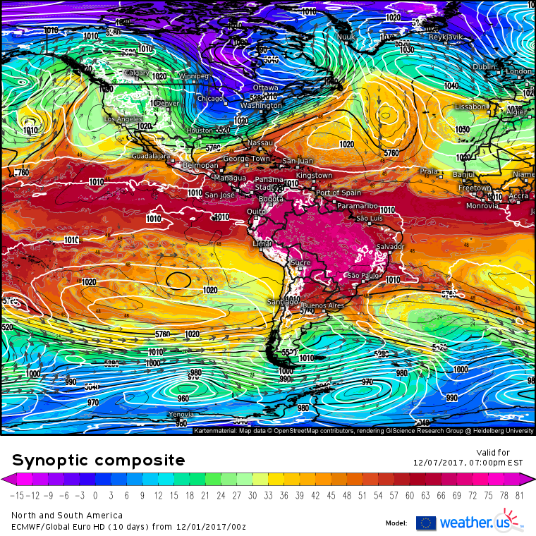
Here’s the pattern forecast 5 days from now. Just a little different than today! The cold air that was bottled up in Arctic Canada has moved south into the Eastern US as a deep trough develops. Meanwhile along the West Coast, the trough in place today has been replaced by a large ridge. Instead of winds aloft blowing from west to east, they’re blowing from north to south across a large part of the Central US. Additionally, where zonal winds once dominated in the Atlantic, a large storm is now present. This storm is important because it is helping to slow down and amplify the jet stream. This amplification will allow warm air to surge north in some places, and cold air to surge south in others. Along the boundary between airmasses, storm development is something to watch carefully for.
So what’s behind such a drastic pattern change?
A storm system is forecast to form over the Great Lakes on Monday. This system will play a big part in the pattern change. For more details on the storm’s direct impacts (rain/snow etc.), check out this post. As the storm develops, it will draw warm moist air northward towards Hudson Bay. This warm air will displace cold air currently locked up in the Hudson Bay area, which will be forced to surge south behind the system. This same process will be occurring at the same time off the West Coast as well, helping to cement the effect. By the time the storm leaves in the middle of this coming week, our pattern change will be complete.
So we know the cold is coming, what about storms?
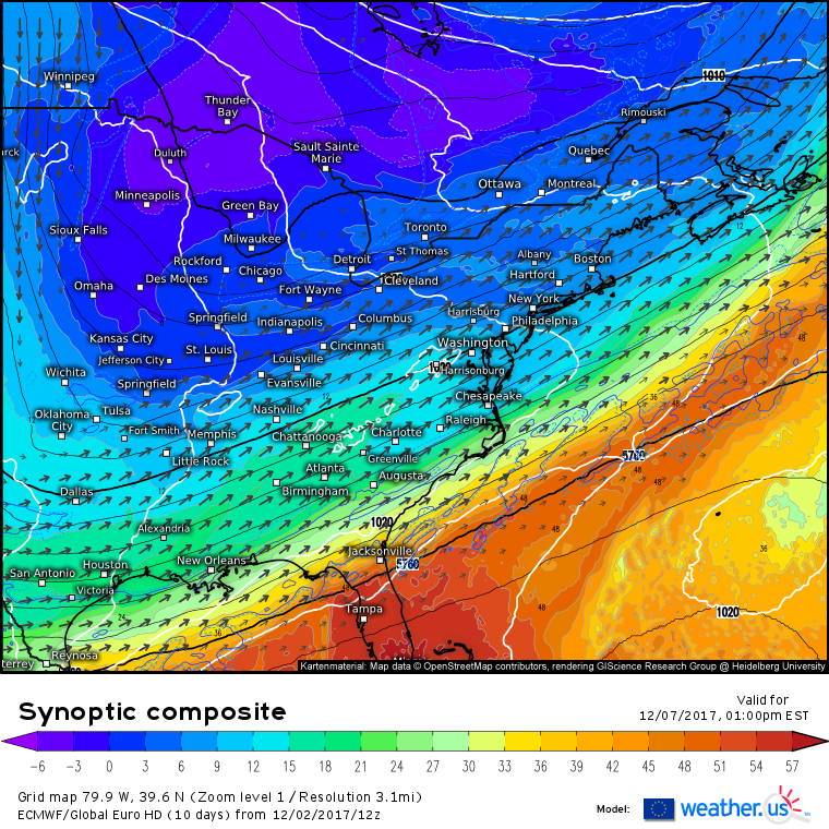
The setup we’re left with after the cold front associated with the Great Lakes system moves through is very favorable for East Coast storm development. Storm development is best watched on the synoptic composite product (what’s that?) which shows each of the components you need for storm development. Notice the tight gradient between warm and cold air over the Mid Atlantic. This gradient is loaded with baroclinic potential energy. Baroclinic potential energy is simply the amount of energy stored up in a thermal gradient. In order for the potential energy to be released into kinetic energy (wind), you need a trigger, like an upper level disturbance. Upper level disturbances will show up as kinks in the black lines on the synoptic composite. Notice that there is a kink in those lines over the Plains. We’re all set for a potential storm to develop!
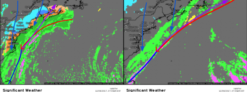
Despite the generally favorable setup, there’s no guarantee that the East Coast sees snow from this system. A comparison of two models (GFS on the right and ECMWF on the left) shows the two basic possible ways this system could evolve. The ECMWF has a strong low pressure center in the Central Atlantic on Friday morning. This system has forced a ridge of high pressure over Bermuda north and west, causing the cold front from Tuesday’s system to stall out. The stalling front and strong high pressure then allow the developing storm off the Carolinas to track NE, bringing rain and snow to the East Coast.
Other models, such as the GFS and German ICON, however, offer a different portrayal of the situation. They keep the Central Atlantic low much farther east than the ECMWF. As a result, the ridge of high pressure near Bermuda is weaker and farther east. This allows Tuesday’s front to keep moving east, eventually dragging the storm ENE offshore. The GFS/ICON solution would allow for mostly dry conditions along the East Coast, instead of accumulating snow.
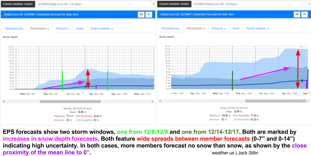
ECMWF ensemble forecasts (what’s that?) are a valuable tool to utilize in these situations where there’s some uncertainty in the forecast. By comparing the 51 different ensemble forecasts in one graph, we can get a clear sense of the range of possible forecast outcomes. In this case, the forecasts for snowfall in NYC range from 0″ to 7″ for the late week system. The average forecast is right around an inch, meaning that there’s a solid group of ensemble members that don’t forecast any snow (support the GFS/ICON solution).
Looking farther out in time, we see ensemble support for another, potentially larger, system in a couple weeks. It’s way too early to look at any specifics for that storm, and it may not happen at all, but the ensemble signal for additional snow highlights the potential that this pattern has to bring snow to parts of the East Coast.
You can get ensemble forecasts for any location in the world here: https://weather.us/forecast/ensemble
Be sure to watch the model maps on weather.us in the coming days to keep tabs on this system! I’ll have more information as the week progresses and the forecast comes into clearer focus.
-Jack
