Large Pattern Change To Bring A Taste Of Spring To The East This Coming Week
Hello everyone!
As last night’s Northeast snow storm races quickly into the Canadian Maritimes, our attention now shifts to a system dropping into the Pacific Northwest which will bring rain and mountain snow to that part of the country, but more importantly will usher in a large scale pattern change that will bring cool and unsettled weather back to the Rockies while the East basks in springlike warmth. Along the boundary between seasons, stormy weather is expected with some flooding issues possible in parts of the Plains due to several rounds of heavy rain over the next several days.
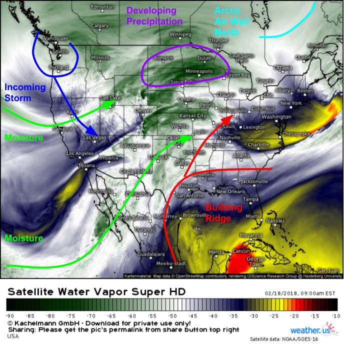
GOES-East water vapor satellite imagery (what’s that?) shows all the elements lining up for the upcoming pattern change. An impressive disturbance is currently diving SE through the WA/OR area, and as it loses latitude, a ridge building over parts of the Deep South will begin to gain latitude. Meanwhile, moisture is streaming into the center of the country from the Pacific, and as the ridge builds and pivots east, the Gulf of Mexico’s moisture supply will go from shut off to open for business.
This is the ECMWF’s synoptic composite map (what’s that?) showing what we’re left with after a couple days of this process. This map is valid 7 PM Tuesday, and shows a highly amplified pattern with a large trough in the west and a large ridge in the east. Between the two, strong southwesterly winds are noted transporting heat and moisture directly from the Gulf of Mexico all the way to Canada ahead of a slow moving cold front. These SW winds will fuel anomalous warmth in the east, and the orientation of these winds parallel to the cold front will enhance flooding risks for parts of the Plains. Cool and unsettled weather will develop over the Rockies, however with little in the way of moisture, no overly significant rain or snow is expected.
This temperature anomaly map from weathermodels.com that uses NWS forecast data shows the consequences of such an amplified flow regime. The country will be split in two, with temps 20 to even 40 degrees above normal in the East, and temps just as cold compared to normal in the west. Map from weathermodels.com.
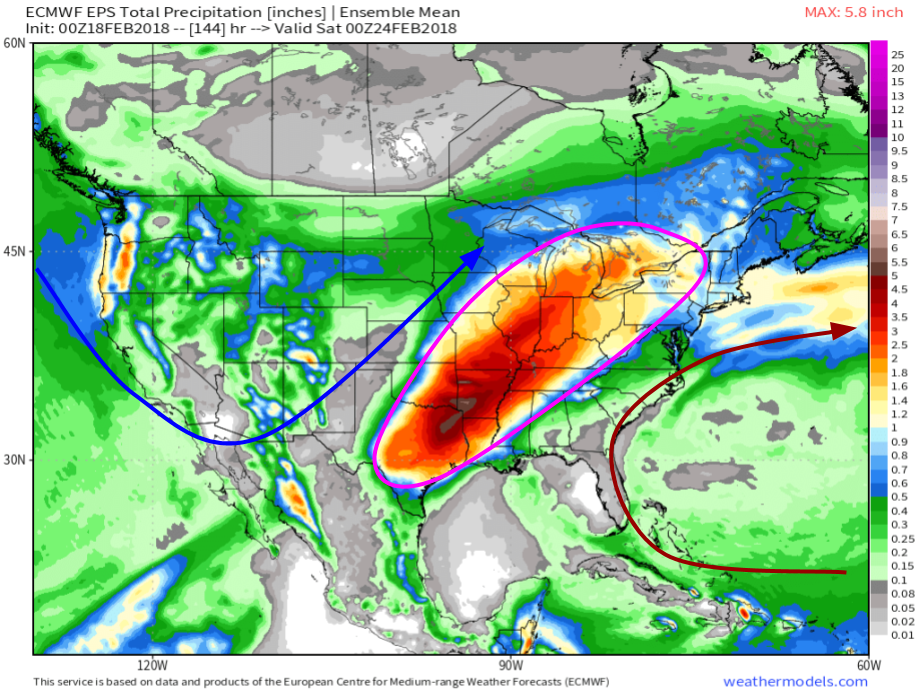
It’s easy to pick out one of the main impacts of a pattern like this on the ECMWF Ensemble Prediciton System total precipitation map. This takes all the total precipitation forecasts (both rain and snow) from each of the 51 EPS members, and averages them to produce a middle of the road forecast solution. Notice the large area of 2-5″ rainfall totals from Texas up through the Southern/Central MS valley and into the Great Lakes. Because these ensemble members cannot resolve convection, amounts may locally be much higher due to training thunderstorm cells, a process supported by the winds aloft oriented parallel to the frontal boundary (SW-NE). Given the wide area this heavy precipitation is expected to cover, some river flooding is possible in addition to the localized small stream flooding you’d typically expect from heavy rain events.
Map from weathermodels.com.
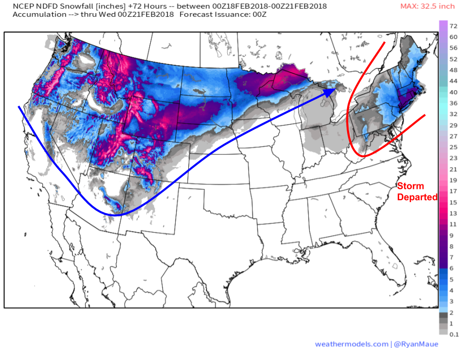
So we’ve covered what’s expected on the warm side of this system with much above normal temperatures and the threat for flooding, but what about the cold side? Significant snows are expected across much of the Rockies as the trough settles into place over the next couple days. Once the pattern establishes itself, any remaining moisture will dwindle, but in the meantime, there remains an abundant supply of moisture from the Pacific flowing into this area. As always, snow totals will depend heavily on elevation, but the highest peaks could see over two feet between now and Tuesday. Note that the values on this map over the Northeast reflect snow that fell last night, no additional snow is expected on the warm side of this week’s pattern.
Map from weathermodels.com.
For more on exactly what this pattern will bring to you, check out our town by town forecast products such as Forecast Essentials (a quick look) and Forecast Ensemble (more detailed information on the range of possible outcomes). Track the evolution of this pattern with GOES-East WV satellite imagery, where you can watch all the elements fall into place over the next couple days. Also keep an eye on HD radar imagery (click the map to zoom in to state level for HD imagery, and again for an even closer county level look) to watch any areas of precipitation.
-Jack


