Jose Continues To Move North As Maria Continues To Strengthen
Hello everyone!
As we discussed last night, the tropics continue to be extremely active with three systems currently in the Atlantic. Only two of those are of interest to us, as TS Lee is forecast to become a tropical depression and dissipate in the coming days. Hurricane Jose is moving north towards New England, where it will bring impacts similar to a strong nor’easter this week before moving east. TS Maria is forecast to intensify into a hurricane today as it moves WNW towards the some of the same Caribbean islands ravaged by Irma. The system could pose a long-term threat to the US but there’s too much uncertainty in the day 7-10 timeframe to talk too much about US impacts.
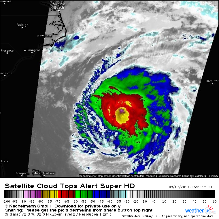
Jose’s appearance on satellite has improved quite a bit in the past 12 hours, with a reasonably symmetric system now visible. Strong thunderstorms are located over the center, but there are currently no indications that an eye is reforming. Shear and dry air do continue to take their toll, and there are some signals that the mid level center is becoming displaced away from the low level center. Either way, Jose only has a short remaining window over warm waters before the cold New England ocean drains the storm’s energy. This will not be a major landfalling hurricane event for New England or the Mid Atlantic. However it also isn’t a clean sweep OTS. There will be some impacts for the coastline even though the center of the storm will remain over water.
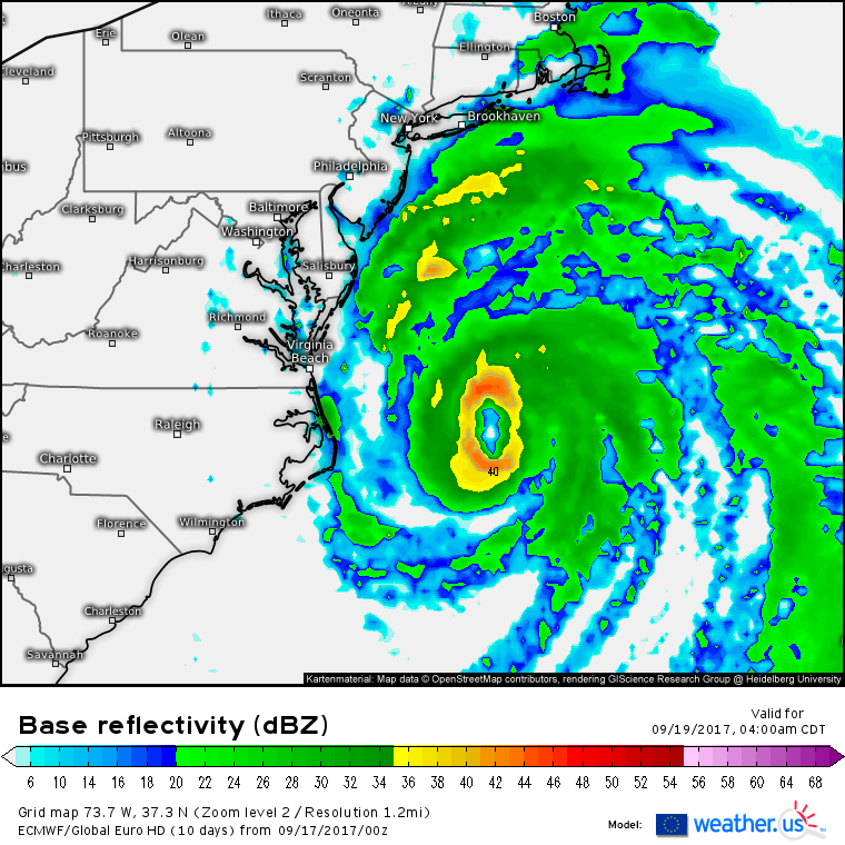
Jose’s outer bands will brush the Mid Atlantic coast tomorrow night into Tuesday morning, and gusty showers are possible from the Outer Banks up through New Jersey. Impacts shouldn’t be too extreme, however, as the core of the system stays well offshore. Winds in this region will range between 20 and 30 mph with some gusts to TS force (40 mph) possible. The timing for gusty showers in these areas will be the second half of Monday into the first half of Tuesday.
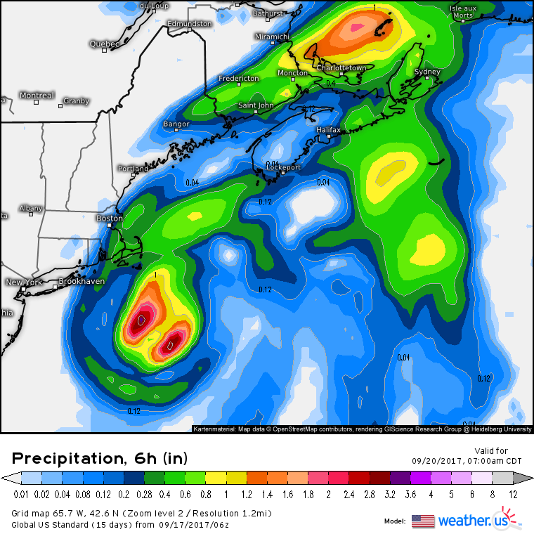
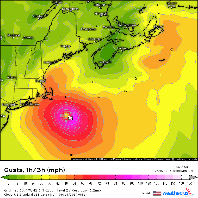
The system will begin to turn ENE on Wednesday as it passes south of Cape Cod. Again, the core is expected to remain offshore, but tropical storm conditions are possible along the cape in the outer part of Jose’s circulation. Winds will be stronger, and rains steadier, in Cape Cod as the storm expands over the cold waters.
Wind gusts on the Cape and Islands will range from 50 to 65 mph as the center of the storm passes offshore. While this is a far cry from some of the stronger hurricanes that have hit this region over the years, it still could be enough bring down some trees and cause some power outage threats. A couple of inches of rain are possible as the outer bands pass over the area. Lighter showers are expected farther north and west, with precipitation potentially spreading all the way up into Maine.
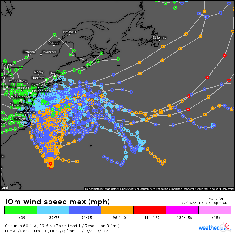
The track forecast for Jose beyond the general North movement in the short term followed by a turn East on Tuesday/Wednesday is basically a guessing game at this point due to a very complex upper air pattern.
This uncertainty is highlighted in this EPS track map which shows an extremely wide spread in possible solutions for Jose. Some guidance continues to take the storm east, out to sea, but unfortunately the signal for that appears to be dwindling. Most guidance has the system making a loop back around to the south and west, with the magnitude of that movement varying greatly. Where the system finally ends up has yet to be determined, but it’s looking like we’ll be talking about Jose for many days to come. Curious about what ensembles are, why they’re useful, and how to use maps like this at weather.us? Check out this video for the answers!
Here are some ways to track the storm yourself over at weather.us.
- GOES-16 1 minute satellite imagery. Use the menus to select which satellite view you want, and get updated images every minute to see what the storm is up to in real time. Click the map to zoom in, or click near the edges to pan. The (-) button allows you to zoom out. For more on how to use satellite imagery, check out this video.
- ECMWF and Swiss Super HD Model forecasts. Use these models, along with the others we have on weather.us, to see the forecast for Jose. Watch rain bands move ashore with Simulated Radar, or keep an eye on wind speeds using either the 10 minute mean wind or the wind gust parameter. There are many other parameters you can access via the menus to the left of the images! Similarly to the satellite imagery, you can click the map to zoom in, or click near the edges to pan. The (-) button allows you to zoom out.
- Forecast XL. What will Jose bring to your town? Find out with our Forecast XL product! Compare model forecasts for winds, temperatures, and precipitation in just a few simple graphs. For more on Forecast XL and how it works, check out this video.
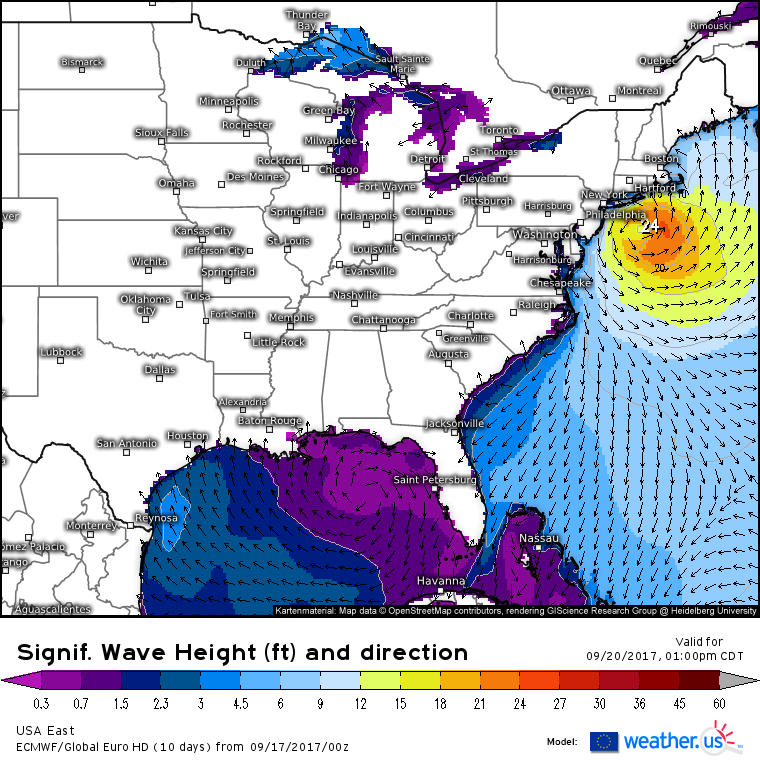
In addition to all the potential impacts from the outer bands of Jose, very high surf continues to be a concern for areas that won’t see a drop of rain or a puff of wind from the system. ECMWF wave forecasts show long period swells thundering all the way down to the Caribbean where the threat for rip currents will be high, even well away from the storm itself. The closer to the center you go, the higher the waves will be.
As Jose weakens close to the US coast, Maria will be intensifying deep in the tropics.
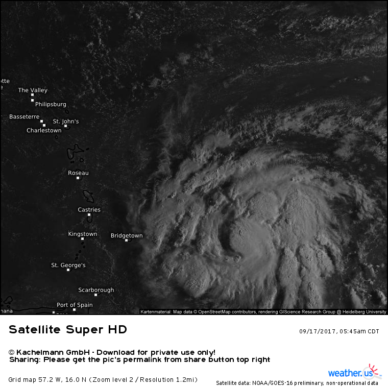
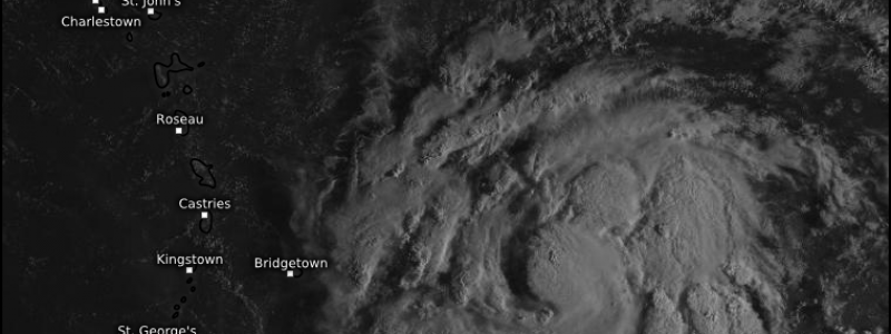
Less than one day into its life as a tropical storm, Maria already has an excellent satellite presentation. Strong thunderstorms are noted both over the center of the system and in well organized spiral bands developing away from the center. The storm is symmetric, and cirrus patterns indicate very strong outflow in all directions. The storm is in an extremely favorable environment for intensification. If you read my discussions for Irma, you’ll remember that we look for 4 things when forecasting rapid intensification of a tropical cyclone: warm water, low shear, high moisture, and an organized inner core. Satellite imagery shows that we can check off that last item, but what about the others?
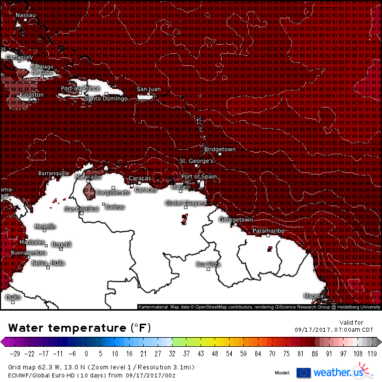
Water temperatures are plenty warm enough to support a major hurricane in the NE Caribbean. Typically you need water temperatures above 80 degrees to support a hurricane. ECMWF data show water temperatures at or above 85 degrees in the path of Maria. While Irma and Jose have left cold wakes north and east of the Leeward Islands, Maria will be moving south of that colder water, and thus will have no trouble finding enough energy to become a powerful system.
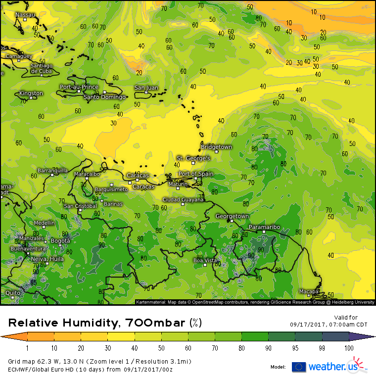
While there is some drier air in the mid levels to the west of the system, it’s not bone dry, and it’s well removed from Maria’s core. There could be some issues with dry air entrainment over the next few days, but they should be fairly minor. The general mid level moisture situation in the NE Caribbean is favorable for an intensifying hurricane.
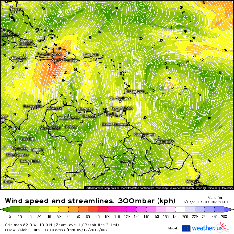
Wind shear will be nonexistent as Maria sits underneath a large area of upper level high pressure. Upper level high pressure is extremely favorable for strengthening tropical systems, because it helps vent air away from the top of the system. Air that has risen through the hurricane’s circulation will pile up at the top of the atmosphere without an upper level high pressure system to vent it away. If there’s too much of a pileup, the air will have no choice but to begin sinking, shutting off the thunderstorms in the hurricane. Maria will not have a problem with this, due to that very large upper level high that is already promoting excellent outflow.
We’ve run through our checklist for intensification and all systems are go. Maria is forecast to intensify into a major hurricane before heading for the island of Puerto Rico. I’ll have more information about the impacts expected from Maria in the Caribbean this evening, along with a look at where the system might head from there. In the meantime, you can have a look yourself over at weather.us.
- GOES-16 satellite imagery. Use the menus to select which satellite view you want, and get updated images every 15 minutes to see what the storm is up to. Click the map to zoom in, or click near the edges to pan. The (-) button allows you to zoom out. For more on how to use satellite imagery, check out this video.
- ECMWF model forecasts. Use these models, along with the others we have on weather.us, to see the forecast for Maria. Analyze the storm’s environment with mid level moisture and upper level wind maps, or watch rain and wind spread across the Caribbean islands with simulated radar and wind speed forecasts. There are many other parameters you can access via the menus to the left of the images! Similarly to the satellite imagery, you can click the map to zoom in, or click near the edges to pan. The (-) button allows you to zoom out.
- Forecast XL. What impacts might Maria bring to your town? Find out with our Forecast XL product! Compare model forecasts for winds, temperatures, and precipitation in just a few simple graphs. For more on Forecast XL and how it works, check out this video.
I’ll have another update on both Jose and Maria this evening!
-Jack
