Intensifying Cyclone To Bring Severe Weather And A Major Blizzard To The Plains Today And Tomorrow
Hello everyone!
All eyes this morning are on the Plains where a powerful storm system will take shape today. The impacts from this system will be wide-ranging, and will include high winds, extreme fire danger, feet of snow, blizzard conditions, and severe storms. This post will do a quick overview of the large scale setup, and will mention some of the factors that will play into each of the impact threats, but if I tried to do a comprehensive analysis of each impact’s nuances, this would be way too long.
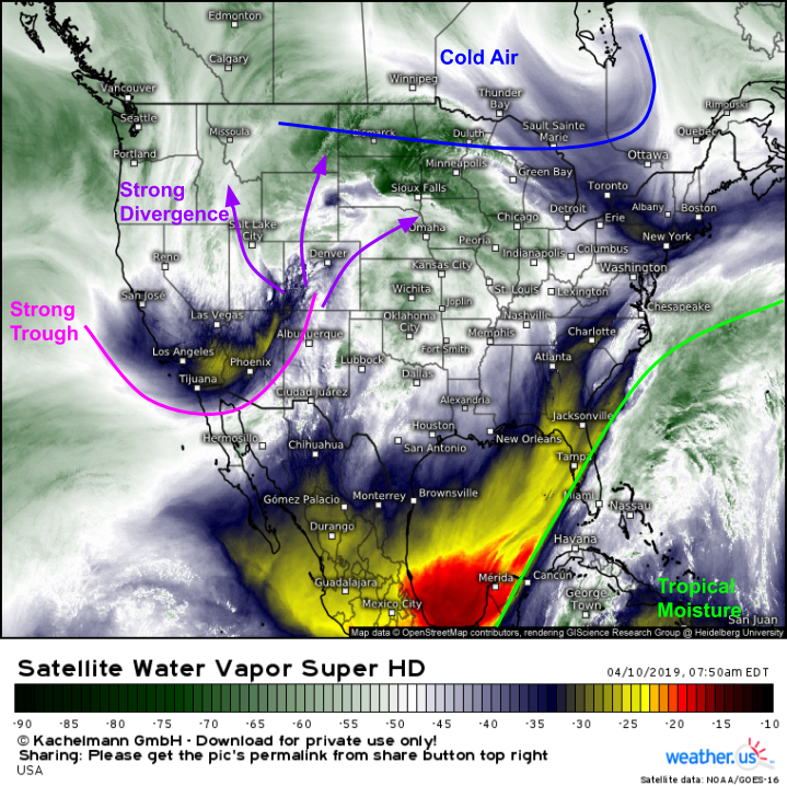
GOES-East WV satellite imagery, as always, provides a great top level overview of what’s happening now across the country. The disturbance that will evolve into the main storm system is clearly visible on the eastern side of a trough located across the Desert Southwest. Strong divergence is noted over Colorado, which is promoting rising air. That rising air is, at the most basic level, what will enable the intensification of the upcoming storm system. Other features to note on the WV imagery include a cold front dropping south through the Great Lakes, which will help provide the cold air needed for heavy snow to the NW of the storm, and tropical moisture located well SE of the storm system across the Bahamas. That moisture is too far away to get caught up into the storm’s circulation, which will limit the system’s potential to touch off severe thunderstorms. Map via weather.us.
Severe Storms
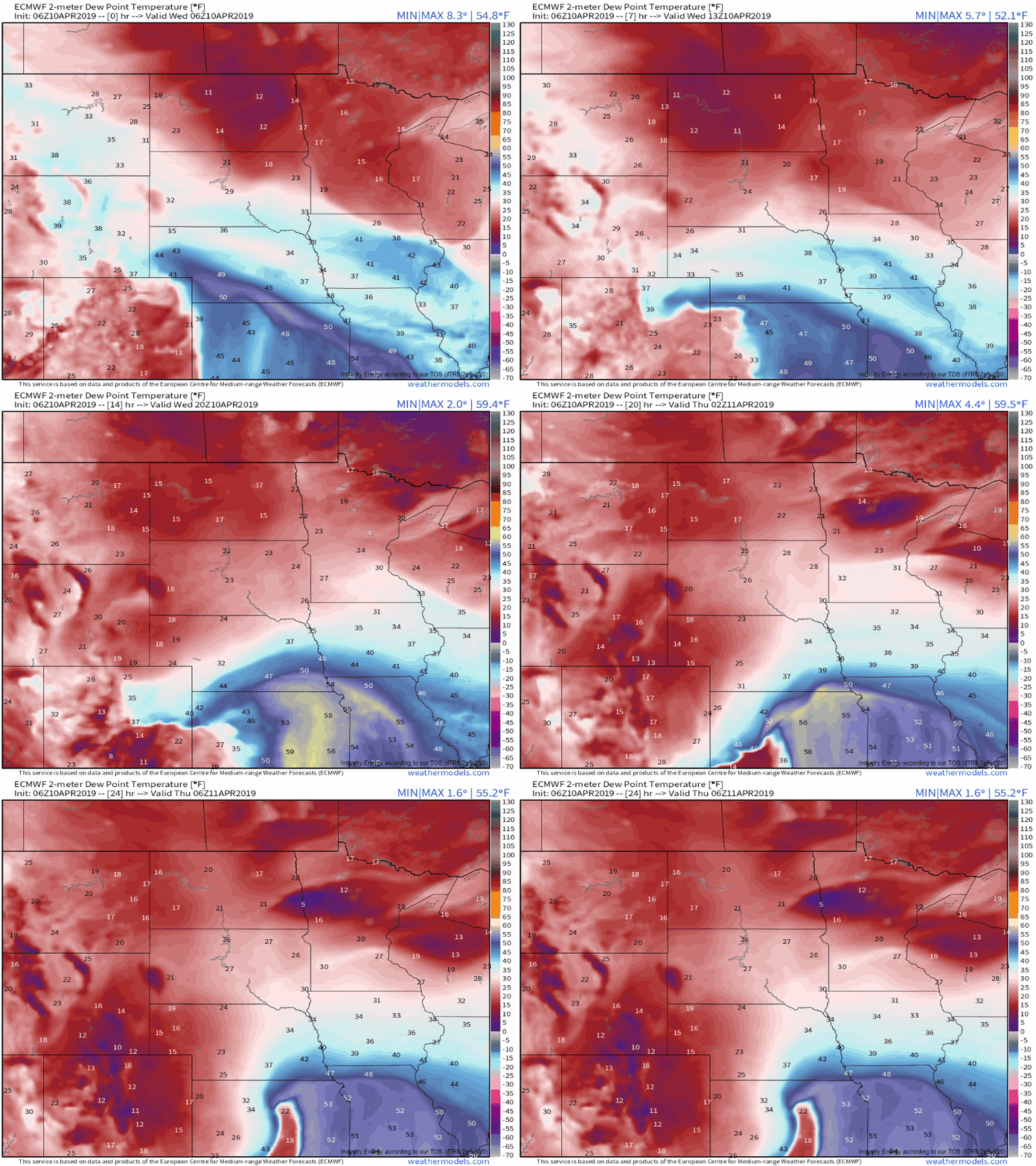
Here’s how the ECMWF sees dew points (moisture) evolving today. Note the slow rise in values this morning before a sharp uptick to around 60F this afternoon/evening. The area we’re most focused on is northern Kansas and southern Nebraska. If dew points indeed got to 60, it would be game on for bigtime severe thunderstorms. The biggest question is, of course, will that happen? GIF via weathermodels.com.
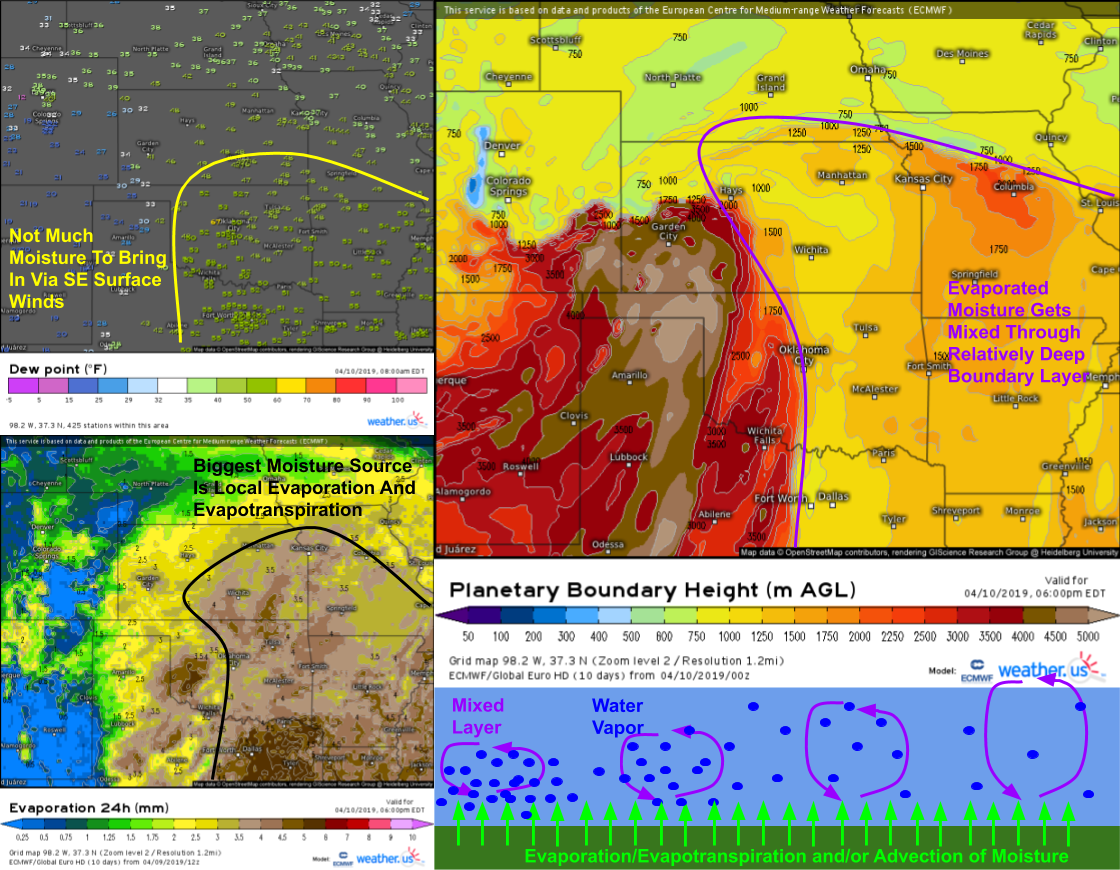
Here’s a slightly more in-depth look at the moisture situation. There’s not much in the way of moisture to be advected (transported) in from the southeast, because remember from the WV image that the deep moisture is stuck all the way down in the Caribbean. So where does the moisture increase shown in the ECMWF loop above come from? The answer is partly advection (the air in Texas is a bit less dry than the air in Kansas), but also partly the result of surface processes known as evaporation and evapotranspiration. You’re probably familiar with the first of those, but perhaps not the second. What’s evapotransipration? It’s the process by which water vapor is released into the atmosphere by plants. When plants open up small holes in their leaves known as stomata to let in CO2 and release oxygen, some of their water evaporates into the air as well. It’s not much, but if you multiply that out over hundreds of miles of cropland, it can really add up! Thankfully for those hoping to avoid severe weather today, most of the Plains hasn’t seen complete leaf-out yet, and many crops are still being planted. Thus the effects of evapotranspiration won’t be as strong as in June or July, but it will still be enough to tack on a few degrees to the dew point and perhaps get some storms going. Maps via weather.us.
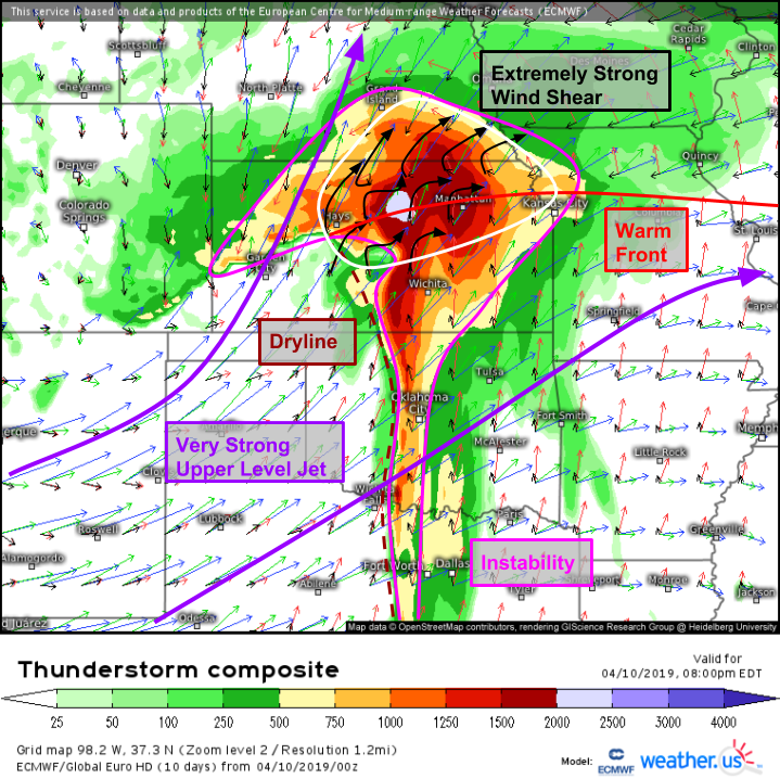
If we can end up with enough moisture for storms, the environment could hardly be better. Wind shear will be about as intense as it gets, especially near the warm front where winds shift from SE to NE. The extreme wind shear will be due in large part to a strong upper level jet that will be pushing well over 100kts from the SW. Strong SW winds will exist in the mid levels too, while surface and low level winds are from the southeast (or, as is the case just north of the warm front, out of the northeast). There will be plenty of instability too as temps rise near the surface, and rapidly cool aloft in response to the approaching trough. Storms will have two options for triggering mechanisms, the first being a dryline stretching from Central Kansas down through Oklahoma and Texas, and the second being the warm front that extends ENE towards Kansas City. Map via weather.us.
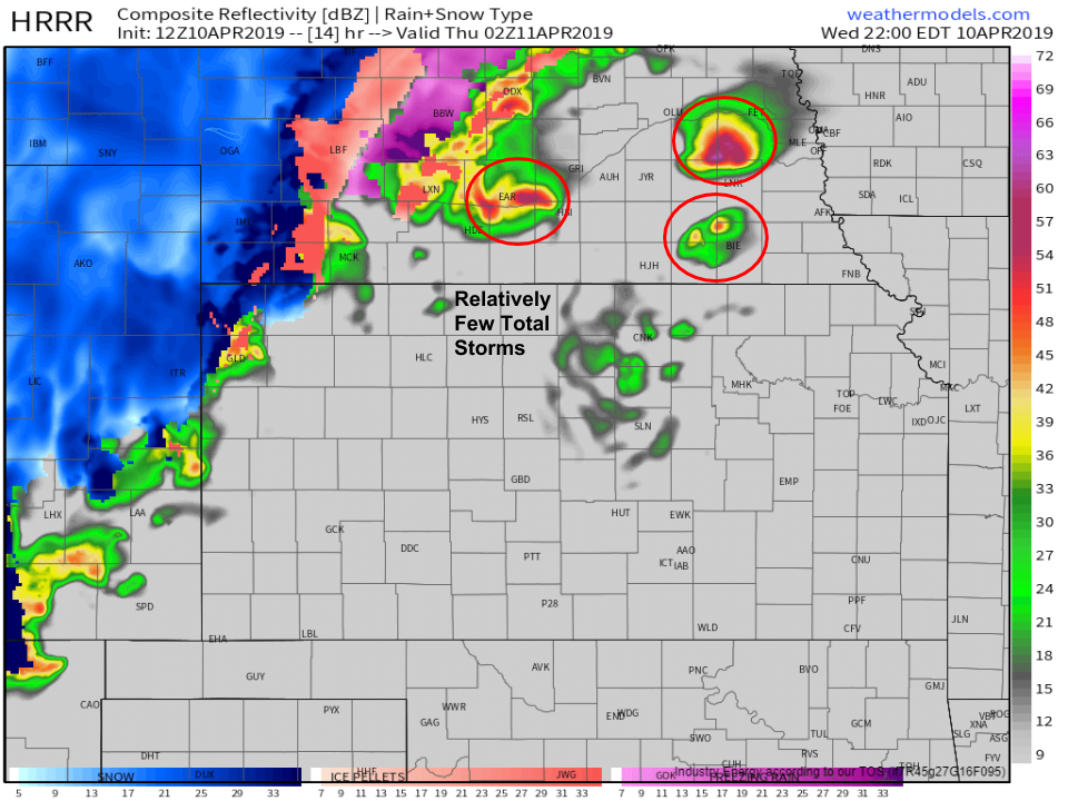
Here’s a look at the HRRR’s forecast for 9 PM CDT. Note the relatively small number of total storms, but the expected intensity of those storms. While the model cannot pinpoint down to a county where particular storms will go, the overall idea is likely not far off. Given the general lack of moisture (and strong capping inversion), there won’t be many storms today, but those that do form will pack quite a punch. The lack of moisture means that tornadoes, while possible, aren’t the biggest threat (you need a relatively low cloud base to worry about tornadoes). The bigger threats will be damaging winds, and especially large hail given the cold air aloft. Map via weathermodels.com.
Blizzard
On the northwestern side of the storm, all eyes will be on the development of heavy snow and fierce winds that will combine to create blizzard conditions, massive snow drifts, and impassible roads.
A snapshot of composite radar imagery this morning shows plenty of snow already in progress over parts of South Dakota and the eastern Rockies. Both of these areas of heavy snow will move southeastward and consolidate around the center of the storm as it develops during the day today. Current calm conditions in places like Denver, Cheyenne, and adjacent parts of NE CO/SE WY/NW NE will quickly turn dangerous in the next several hours as heavy snow moves in, and the wind picks up. Map via weather.us.
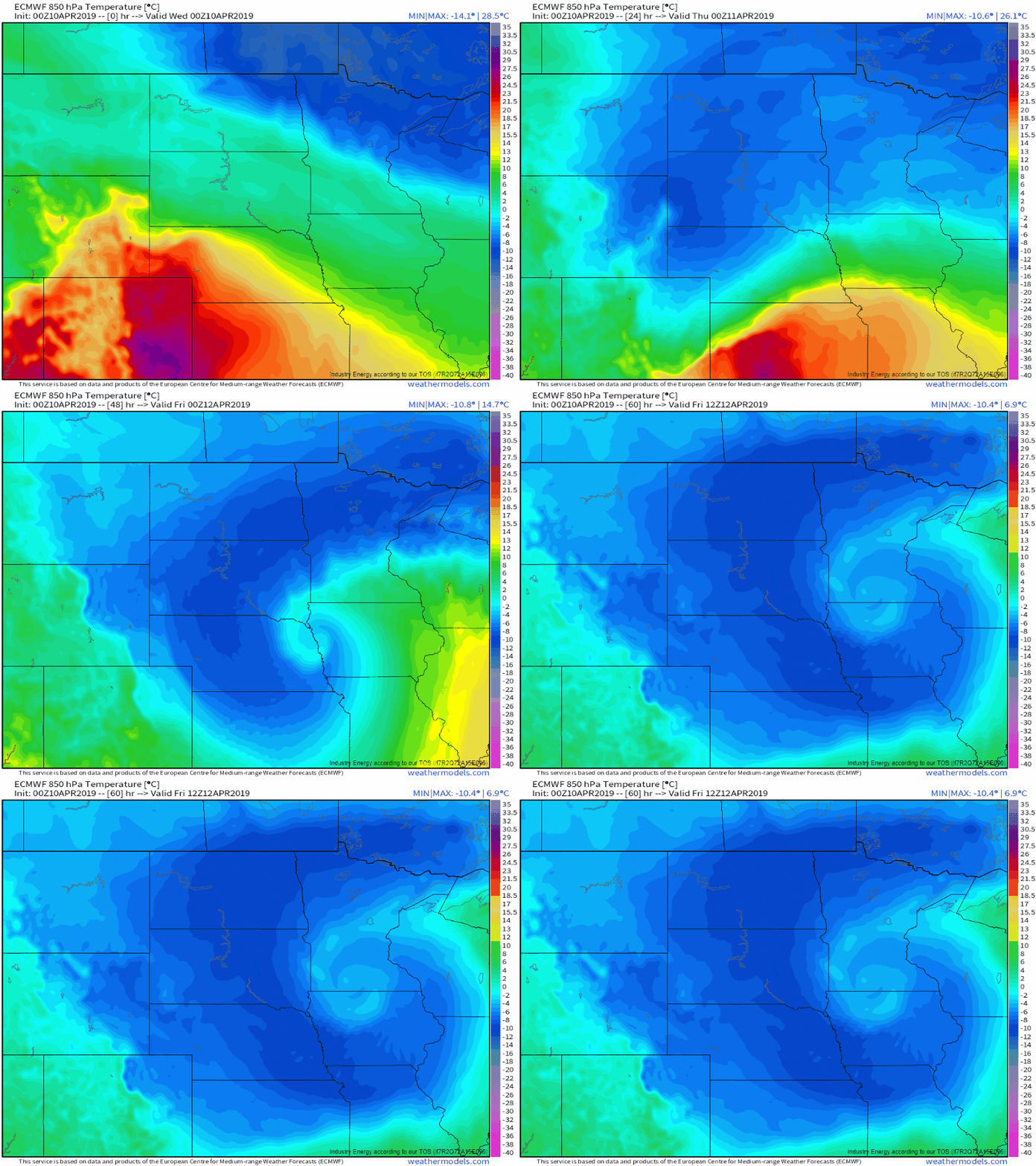
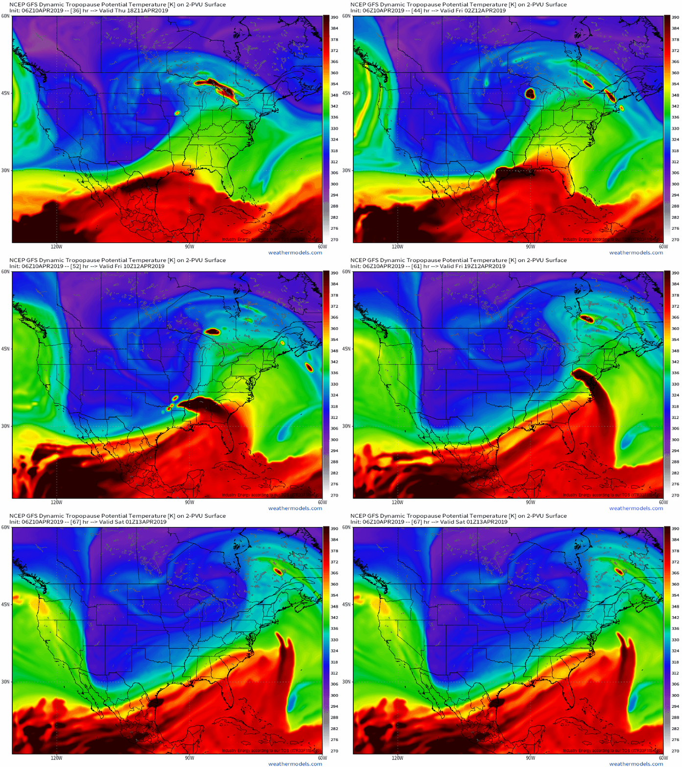
As for the dynamics powering the heavy snow, of course there are many. The most important, and easiest to visualize here, is known as frontogenesis. For those that aren’t familiar, frontogenesis is simply the formation (genesis) of a frontal boundary. The animation above, showing mid level temperatures over the next couple days, shows how frontogenesis operates. Note that the relatively broad temperature gradient across the Plains at the beginning of the loop becomes very sharp during the middle of the loop as the storm reaches its peak intensity, then weakens again as the storm erodes over Minnesota. Map via weathermodels.com.
Frontogenesis creates heavy snow by forcing upward motion as two airmasses crash into each other, and have nowhere to go but up. Of course that’s a bit simplified, but if you’re well versed in vector calculus and want a more complete explanation, I’ll point you to these excellent slides put together by Ted Funk of WFO Louisville. They might be 15 years old now, but are still quite relevant! I hope to find some time during the quieter summer months to write up explanations of phenomena such as frontogenesis that are a bit less technical, but alas there are only so many hours in the day especially this time of year.
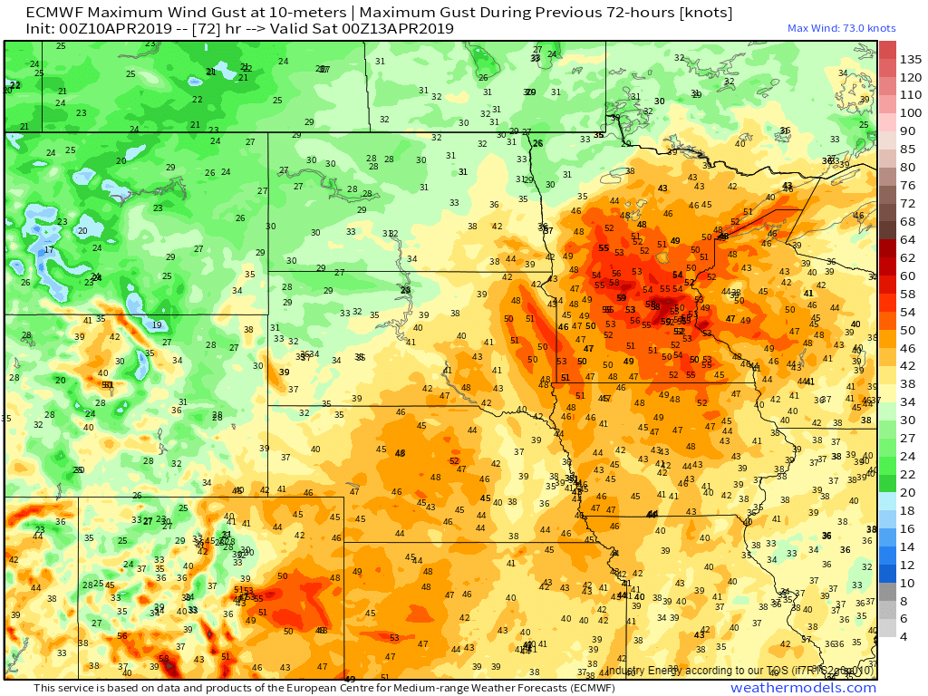
Here’s a look at the ECMWF’s forecast for max wind gust as the storm moves through. The data come out in units of knots, but the parameter typically overdoes forecasts by a bit, so treating these as mph forecasts probably isn’t a bad idea. Note the wide swath of 40-50+ mph gusts forecast from Colorado through Nebraska and South Dakota into Minnesota. Those winds will blow and drift the accumulating snow, leading to near-impossible travel conditions and near-zero visibility. Map via weathermodels.com.
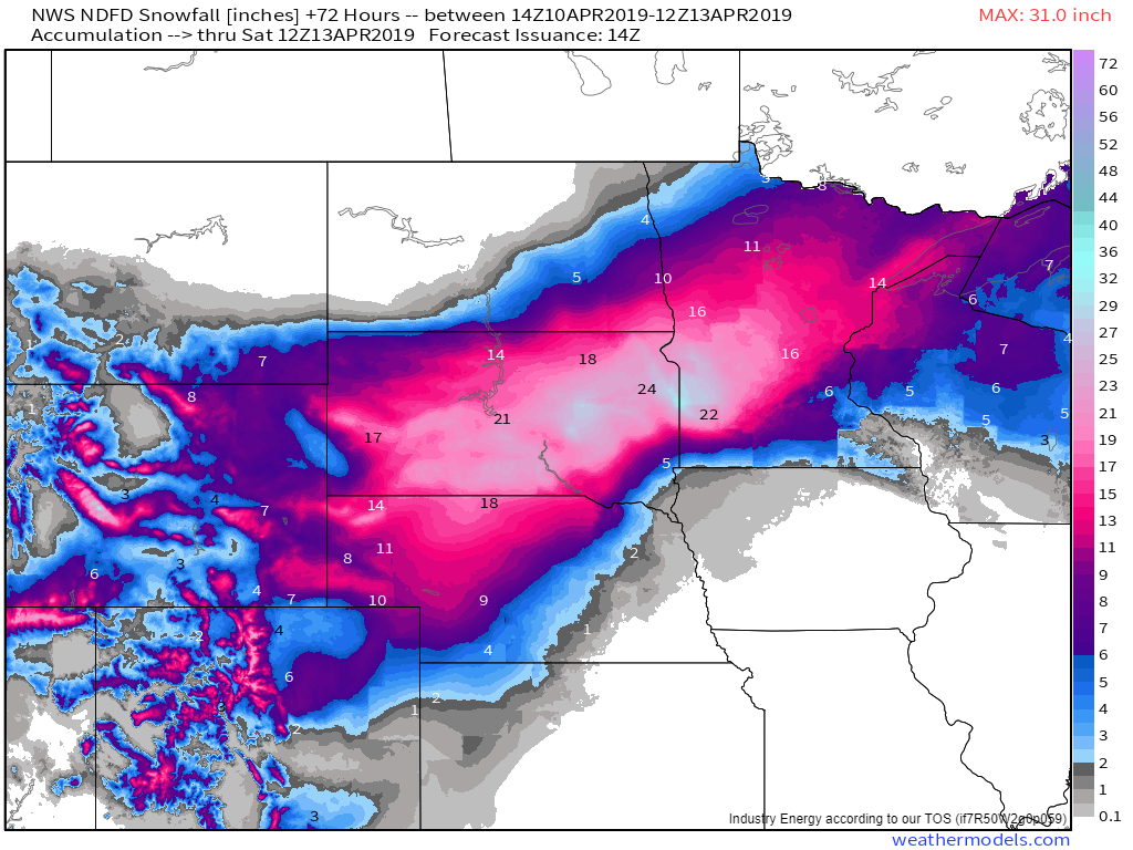
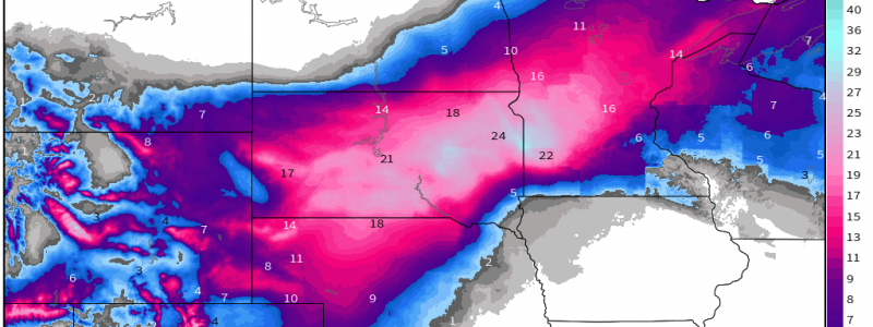
How much snow is expected from this system? Here’s the National Weather Service’s forecast, composed of each local forecast office’s individual forecasts stitched together. The jackpot will be in South Dakota and far western MN where bands of heavy snow will pivot over the same areas for several hours tomorrow as the storm slows down and begins to weaken over Iowa. Map via weathermodels.com.
Fire Weather
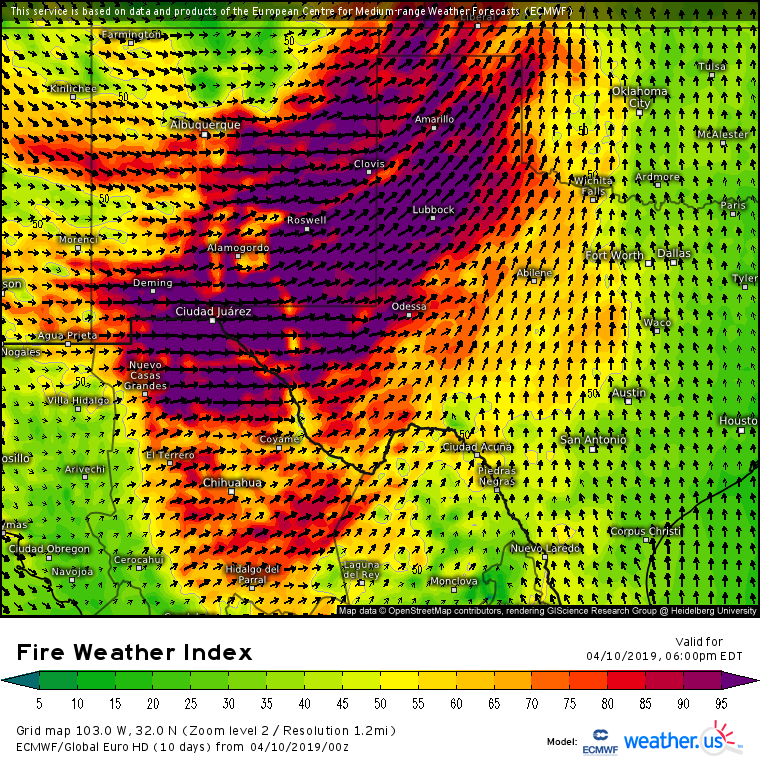
On the southwestern side of the storm, a very dry airmass will be moving northeast off the Mexican desert plateaus. That dry airmass will be transported towards the storm by very strong SW winds to the west of the dryline we’re watching for severe thunderstorm development. The ECMWF’s fire weather index plot shown above highlights the extreme fire danger presented by the very dry air and strong winds. Map via weather.us.
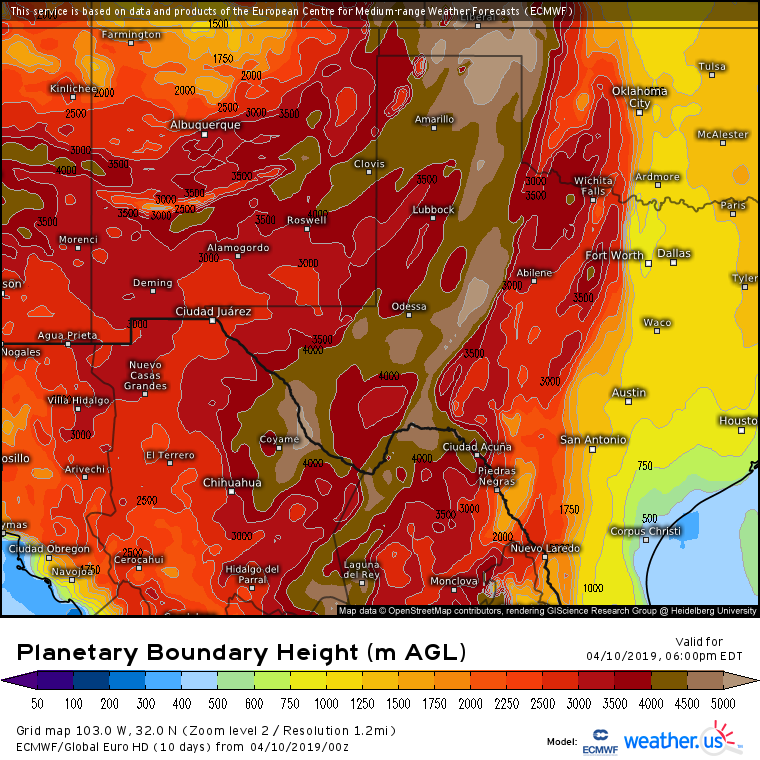
The dynamics responsible for this setup can be traced back to this map right here, showing the depth of the boundary layer. The boundary layer is the layer of air adjacent to the surface that can mix down and interact with the surface at any time. The deeper the boundary layer, the more mixing there is going on in the lower atmosphere. Recall from our discussion of the severe weather threat above that a deeper boundary layer can disperse whatever water vapor might be present in the lower atmosphere through a much larger volume, drawing down the relative humidity. That’s exactly what’s happening here, and RH values across SE NM and W TX are forecast to drop well below 10% this afternoon. Additionally, a deeper boundary layer promotes the downward transfer of momentum from strong winds aloft. This leads to strong winds at the surface, which will fan the flames of any fires that may start. Be very careful in this area today to dispose of any cigarettes properly, and go out of your way not to create any sparks! Map via weather.us.
The storm will quickly unravel on Friday, with impacts limited to relatively minor shower/thunderstorm activity in the Ohio Valley and Northeast. GIF via weathermodels.com.
Follow along with this system and its many impacts using the tools we have at weather.us and weathermodels.com, and also be sure to follow us on twitter @WeatherdotUS, @RyanMaue, and @JackSillin for the latest analysis and info.
-Jack
