Intense Atmospheric River Event Set To Begin Across California Today
Hello everyone!
Today will feature the beginning of an intense Atmospheric River event in Southern California as an upper level low sets up just offshore, and southwesterly flow around that low pushes moisture from the tropics towards the state. While heavy mountain snow will fall in some of the higher elevations of the Southern Sierras, this storm’s main and most dangerous impact will be the torrential rains that will fall over the Thomas Fire burn scar near Santa Barbara. Totals in those mountains could near a foot, which will support extremely dangerous flash flooding and mudslides.
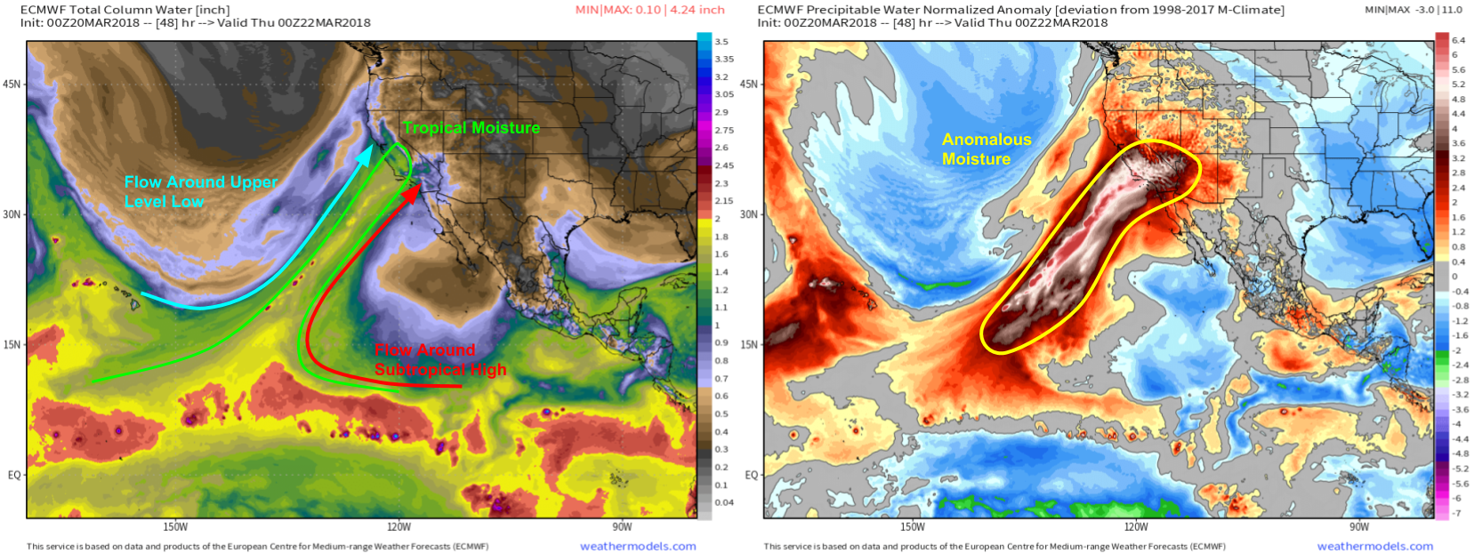
GOES-West Water Vapor satellite imagery (what’s that?) shows the elements lining up this morning for our Atmospheric River event. A subtropical ridge is located to the south of Baja California, and clockwise flow around it is setting up an area of southwesterly winds from the tropical Pacific towards California. An upper level low is located farther to the west, and the counterclockwise flow around that system will further enhance those southwesterly winds from the tropics towards California. It’s that area of strong southwesterly winds that will push the deep tropical moisture into California, and create a “river” of incredibly efficient moisture transport.
ECMWF maps from weathermodels.com highlight this plume of moisture tomorrow evening, near its peak strength. You can see in the Total Column Water map on the left that California is getting a dose of an airmass typically relegated to Hawaii. The map on the right shows the Precipitable Water (moisture) anomaly, showing that the plume of moisture flowing into California is extremely anomalous. Extremely unusual moisture will, perhaps unsurprisingly, translate to extremely unusual rainfall. Maps via weathermodels.com.
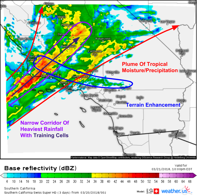
The Swiss Super HD model’s simulated radar forecast shows the result of the moisture plume hitting the mountains of Southern California. HD radar imagery shows rain into San Francisco this morning, and rain will continue to ramp up today and into tomorrow. The rain will also shift southwest with time as the upper low moves east. The image above is valid tomorrow night, but if you step through each of the one hourly timesteps we have forecasts available for, you’ll see a similar situation playing out much of the day tomorrow and into Thursday as well. There will be a broad area of light/moderate rain, and a narrow band of very heavy rain contained within that. That heavy band of rain is likely to become trapped between the high and low pressure systems, and won’t move much to the east or west for hours on end. As storm cells move in the same direction on the same axis, heavy rain will fall on the same areas repeatedly. This “training” process where storms move along that axis like trains on a track is what will produce the prolific rainfall totals, especially in areas that see enhancements from terrain induced lifting.
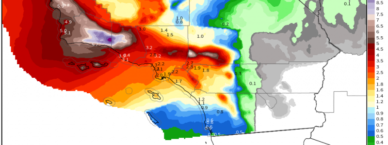
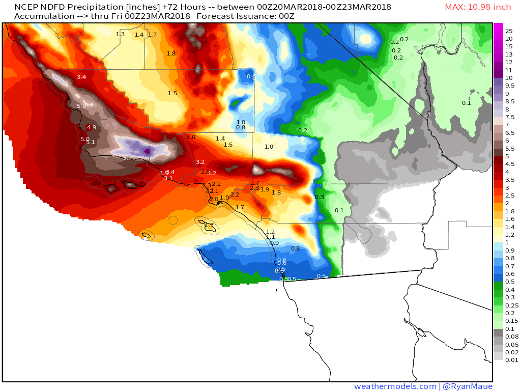
This NWS total precipitation forecast highlights the result of that persistent training process over the mountains of Southern California. Totals over the mountains near Santa Barbara, which is where the Thomas Fire has scoured vegetation from the steep terrain, are forecast to approach the one foot mark by tomorrow evening, just as the rain is beginning to taper off. Excessive rains of this magnitude combined with steep vegitationless terrain is the perfect recipe for flash flooding and debris flows. Evacuations have been issued for some of the areas most vulnerable to this, so be sure to heed the advice of local officials if you do need to evacuate to avoid the dangerous situation. Map via weathermodels.com.
Rain will taper off as we head into the weekend and the upper level low weakens/moves northeast.
Earlier this morning, I posted an update on the continuing severe storm threat in parts of the Southeast. A winter storm in the Mid Atlantic/Northeast will round out our trio of impactful weather systems today/tomorrow, and I will post an update with details on that this afternoon. In the meantime, you can get all your forecast information at weather.us, and keep track of the latest model runs at weathermodels.com.
-Jack


