Imelda Bringing Dangerous Flooding To Texas, Humberto Continues Heading Out To Sea, Jerry Forms East Of The Leeward Islands
Hello everyone!
We’re right in the heart of hurricane season, and the list of tropical systems to keep an eye on certainly reflects that. There are three named storms currently in progress across the Atlantic Basin, though thankfully only one is bringing impactful weather to the US. That system, Imelda, has just moved onshore near Houston Texas where extremely heavy rainfall has been occurring for the past 18 hours or so. The other system we’ve been watching over the past few days, Humberto, is moving steadily ENE away from the East Coast in line with previous forecasts. The storm will turn back to the north later this week, but it will not get close enough to the US for any impacts beyond higher surf. The last named storm to keep an eye on is Jerry, currently located well east of the Leeward Islands. This system doesn’t pose any immediate threat to the US, but is worth keeping an eye on over the next week.
Because there are three systems to discuss, each system’s section will be relatively brief here. For a detailed discussion of the dynamics behind Imelda’s heavy rainfall, check out Monday’s blog. A detailed discussion of Humberto’s steering dynamics can be found in Saturday’s blog.
Imelda
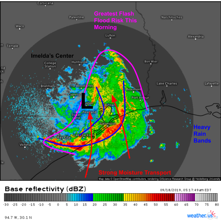
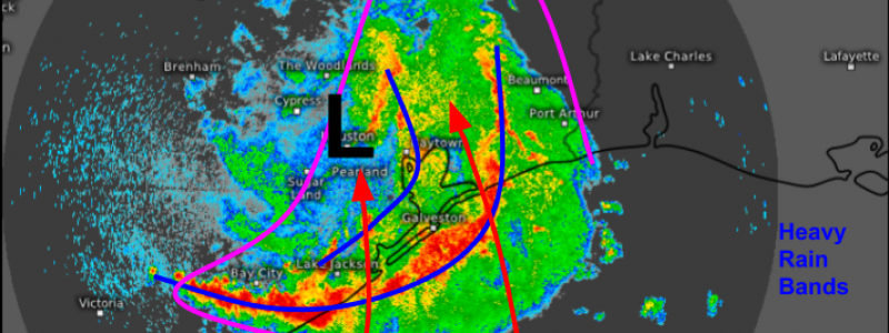
Here’s a look at HD radar imagery out of Houston this morning. Imelda’s center is right near downtown Houston while the storm’s heaviest rainfall is located to the south and east of the center. This is the region where southerly/southeasterly winds are transporting deep tropical moisture in from the Gulf of Mexico. Two bands of particularly intense rainfall are noted in this region, with the outer band having more access to moisture and this producing heavier rain. These bands will slowly drift north along with the system overall during the next few hours. If you live in Houston or are south/east of the city, expect flooding in low-lying areas today.
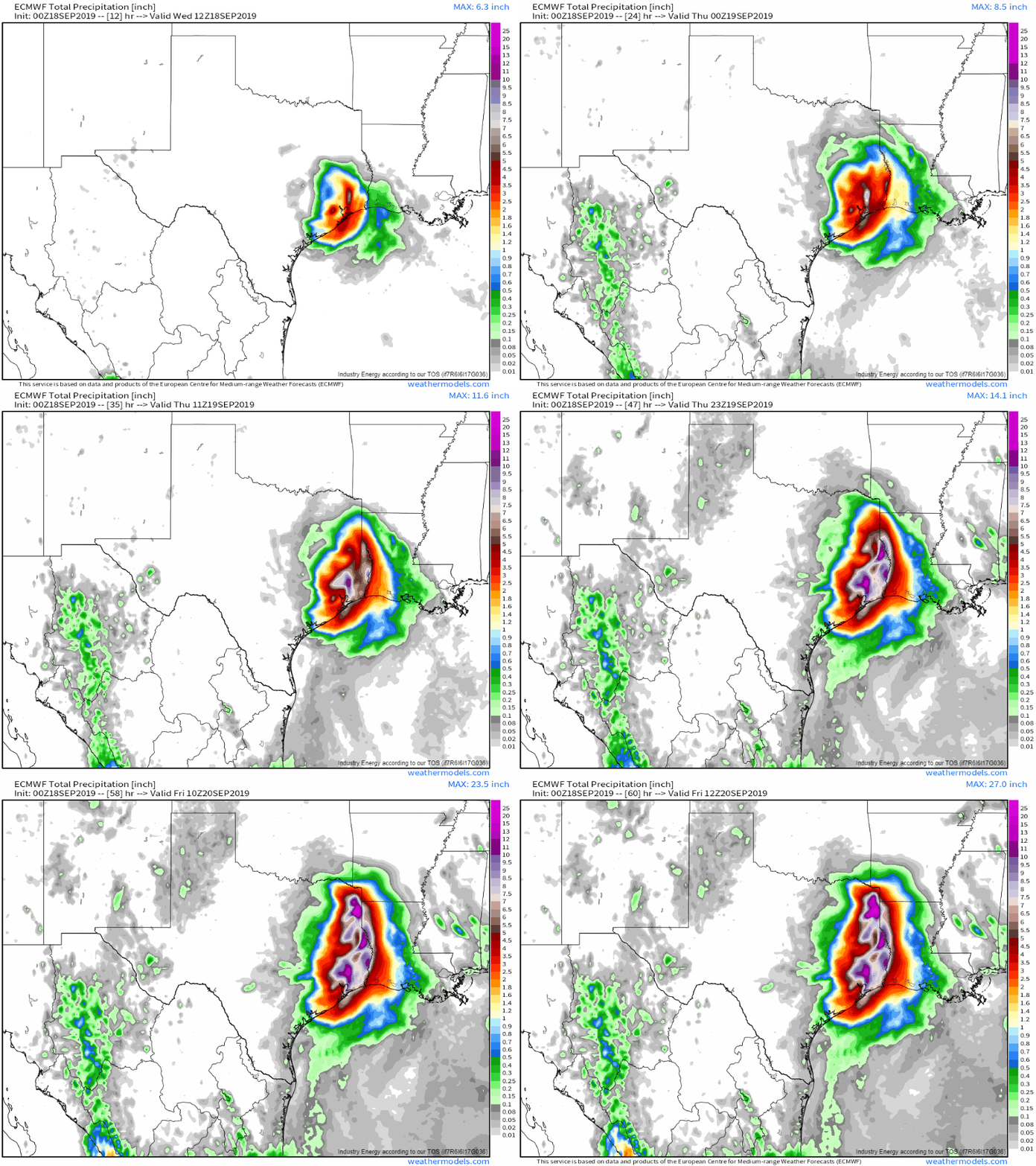
Here’s a look at how much rain might fall today and tonight. The highest totals will be found in eastern Texas within about 100 miles of the Louisiana border. Adjacent parts of western LA will also see heavy rain. In these areas, 6-10″ of rain is a pretty good bet, while the chance for 12-18″ of rain certainly exists depending on exactly how individual storms set up. Areas closer to the center of Imelda’s track will see less rain, and points west of the track will see very little if any rain. The system will slowly run out of moisture as it approaches Oklahoma on Friday. GIF via weathermodels.com.
Humberto
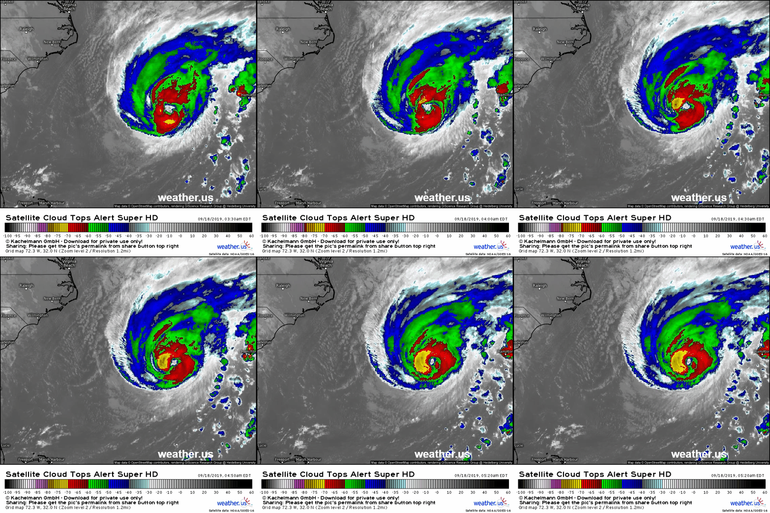
Humberto is moving quickly ENE this morning and will pass just north of Bermuda later today. The storm went through a routine eyewall replacement cycle last night, and thus its inner core was a bit disorganized but the new eyewall has since taken over and the storm is maintaining its organization overall. Bermuda is likely to experience winds near Hurricane strength later today as the storm races by to the north.
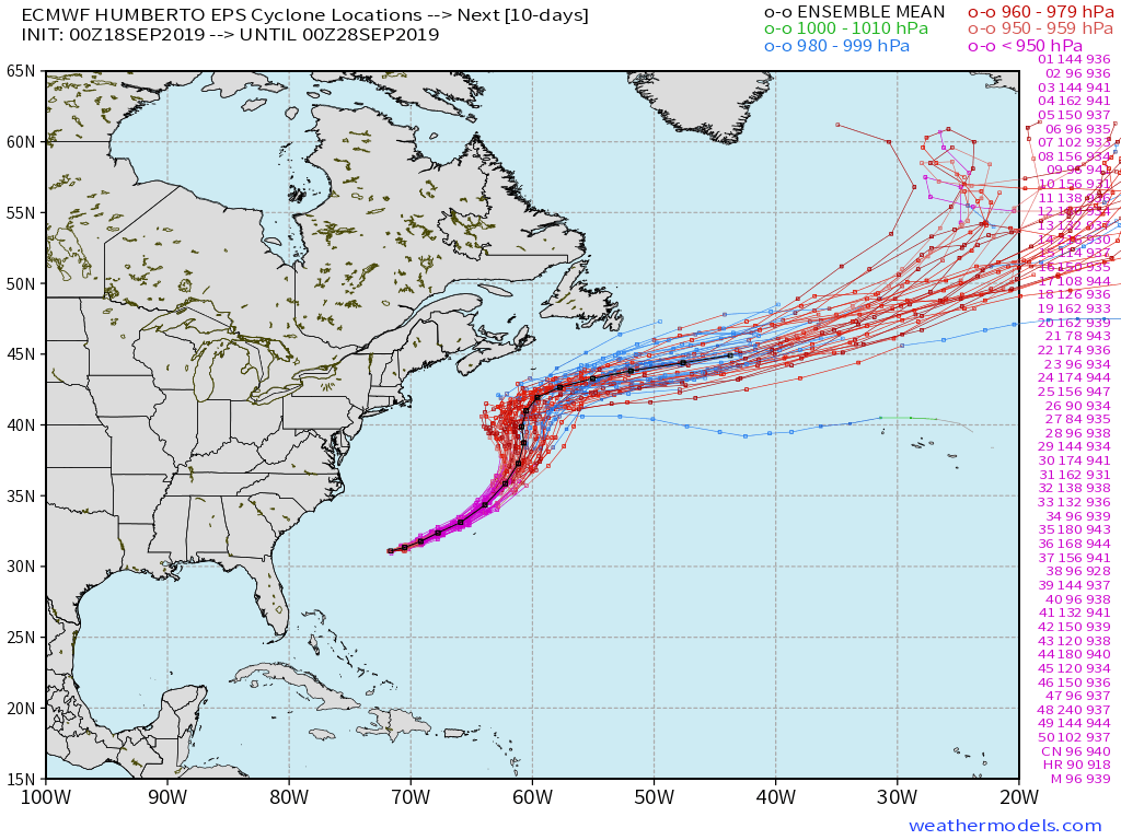
EPS track guidance is now tightly clustered for the next 7 days, and there is high confidence that Humberto gradually turns more to the northeast and then north later this week before making a final turn off to the east once the storm is south of Nova Scotia this weekend. Perhaps parts of Atlantic Canada will be close enough to see some breezy conditions and possibly some showers, but otherwise Humberto won’t threaten any landmasses after Bermuda. Map via weathermodels.com.
Jerry
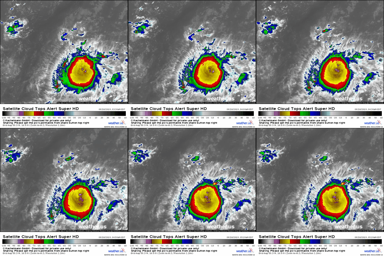
Tropical Storm Jerry formed last night out in the middle of the tropical Atlantic. The storm is looking quite healthy this morning with very cold cloud tops below -80C and robust upper level outflow to the west, north, and northeast. Further intensification of the system is likely over the next few days as it approaches the Leeward Islands.
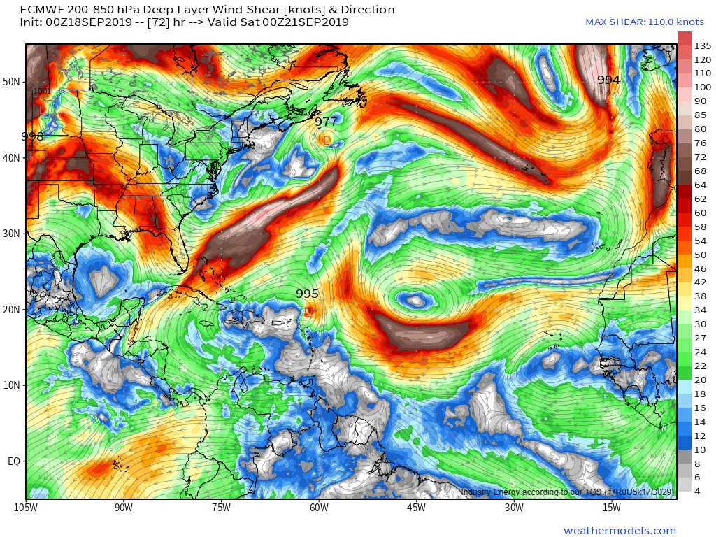
As it moves either through or near the northern Leeward Islands, it will encounter some northerly shear on the west side of an upper level low in the Central Atlantic. This may result in some weakening, but if Jerry is able to build a solid core over the next couple days, it will be able to fend off the shear more effectively. Residents of the northern Leeward Islands should be starting to think about what preparations might be needed later in the week should Jerry’s forecast track end up a little farther south than the ECMWF model above is forecasting. Map via weathermodels.com.
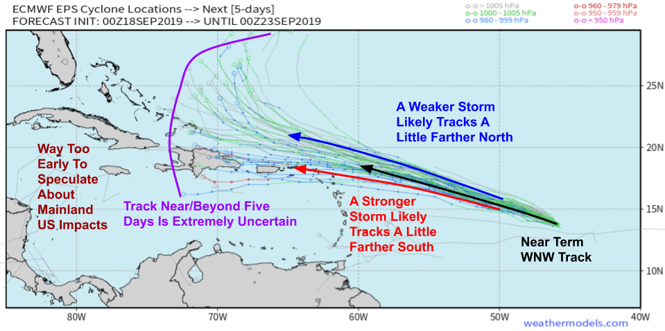
As far as Jerry’s track forecast goes, the next few days are relatively straightforward. The storm will move on a generally WNW heading, while the intensity will determine the exact north/west components of the storm’s motion. A slightly stronger storm will track slightly farther to the south, while a slightly weaker storm will slide a little farther north. Based on satellite imagery over the past several hours, I’m more inclined to favor the southern side of the range of possible outcomes than the northern side, but that could certainly still change. Map via weathermodels.com.
Past day four or so, the storm may interact with a trough left behind by Humberto. This has the potential to turn the system to the north, but if that turn happens, its exact timing has still yet TBD. It’s also possible that the storm misses that connection and continues WNW for a few more days before the next trough arrives. While I can’t rule out mainland US impacts 7-10 days from now, there’s enough uncertainty that if I were in Florida, I wouldn’t be concerned at this point. That being said, keep checking the forecast around once a day so that if things change, you’ll be aware.
-Jack
