Hurricane Isaias Expected To Bring Heavy Rain To A Wide Swath Of The East Coast Tomorrow Through Tuesday, Strong Winds And Storm Surge Also Possible
Hello everyone!
After days of carefully monitoring Isaias and its surrounding environment for hints about its meteorological future, it’s time to start honing in on expected impacts, especially since Hurricane Warnings are now posted for parts of the Florida coastline. If you want a closer look at the meteorological nuances of the forecast, please refer to the posts from yesterday afternoon and this morning.
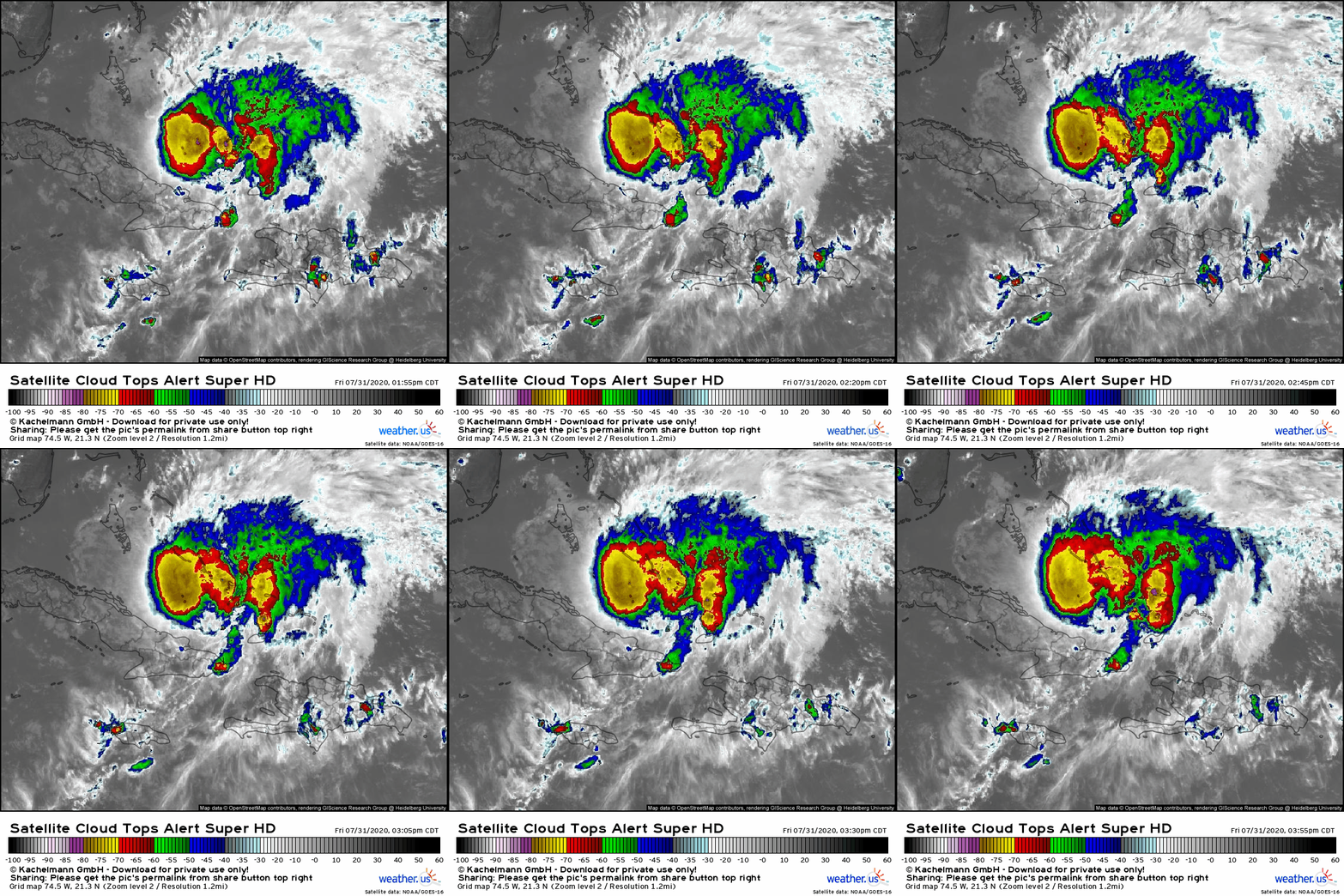
 Before digging deep into the impacts, let’s start with a quick look at the state of the system this evening. When I sat down to write this morning’s post, the low-level center of circulation associated with Isaias was detached from its thunderstorm activity and the storm looked on the verge of succumbing to the dry air and wind shear imparted on it by the PV streamer to its west/northwest. Throughout the day, intense thunderstorm activity has persisted over and even just west of the center which suggests that Isaias is mounting a strong defense against the shear and dry air. As a result, I’d expect the storm to strengthen a bit as it moves northwest tonight. During this time, hurricane conditions will impact much of the Bahamas. Preparations in parts of the island chain not yet impacted by Isaias should be rushed to completion in the next few hours.
 Isaias will approach the SE Florida coastline as a hurricane tomorrow night. Conditions will start deteriorating in the afternoon as the storm’s outer bands approach. You have about 24 hours left to prepare in this area. In this morning’s blog, I discussed in detail how a stronger storm would tend to track farther east. Most model guidance today showed Isaias making landfall near West Palm Beach. However, most of that model guidance also showed Isaias falling apart and becoming a weak/moderate TS by tomorrow afternoon (hence the westward track). Given that the storm has nearly closed off an eyewall and looks poised to intensify further tonight. With that in mind, I’m inclined to think that today’s model guidance showing the storm evaporating on approach to southern Florida is unlikely to verify. Instead, I think that the east coast of Florida is likely to get brushed by the western edge of the storm’s inner core as it moves by just offshore. Combine this track with the sharp gradient in wind speeds associated with friction due to land, and you end up with a situation where every mile counts between the northern suburbs of Miami and Cape Canaveral. Any wobble to the west will bring intense winds farther inland. Any wobble to the east will turn this from an impactful hurricane into a breezy day. Which way will the wobbles go? It’s impossible to predict until they happen. So if you live along this part of the Florida coastline, you need to be preparing now for hurricane-force winds. If the storm wobbles east and you end up with minimal/no damage, consider yourself lucky.
The same general idea goes for storm surge too, though if the center remains offshore (a distinct possibility based on trends this afternoon), I would expect surge concerns to be relatively limited given prevailing along/off-shore flow.
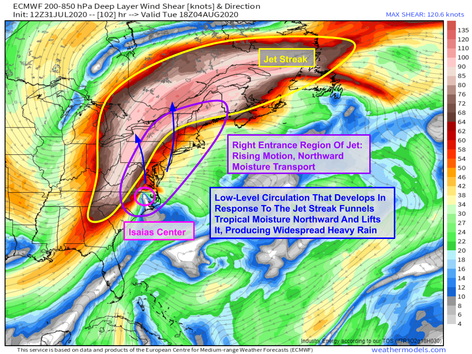
 As mentioned both yesterday and this morning, the biggest impact from Isaias will be heavy rain across a very wide swath of the East Coast. As the storm tracks north through the right entrance region of an intense upper-level jet streak, tropical moisture from its circulation will be funneled northwards and upwards over the Mid Atlantic and Northeast. This combination will produce bands of heavy rain even hundreds of miles ahead of the storm’s center of circulation. This pattern (known as a “Predecessor Rain Event” or PRE) is a classic recipe for flooding in this part of the country. If you live along or east of the Appalachians and your area is prone to flooding, now is the time to start preparing for high water.
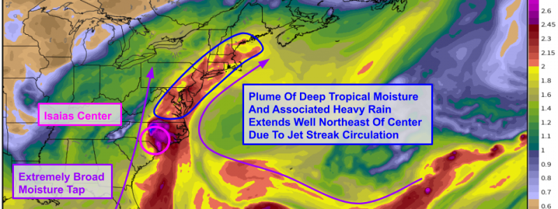
 Another way of looking at this setup is with precipitable water forecasts which show the amount of moisture available in the atmosphere. Areas with PWAT values >2″ are ripe for extremely heavy rain. Note that the plume of such deep moisture extends well ahead of the center of Isaias.
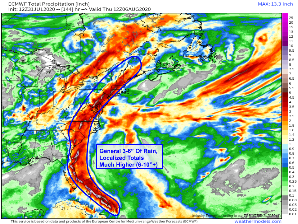
 Here’s a rough idea of how much rain to expect based on model guidance and a brief look at some previous events that looked similar. A wide swath of the East Coast is likely to see heavy rain of 3-6″ as Isaias moves north and feeds the jet streak with deep tropical moisture. Within that broad area, some spots will see much more rain. You can see the ECMWF’s depiction of such localized precipitation maxima in the white/purple splotches embedded within the larger red swath. Note that I’ve expanded this swath a bit NW of what the model is suggesting over the Northeast. Aside from localized rain shadows (Catskills/Pocanos/Adirondacks/ Greens/Whites), I think there’s plenty of room for heavy rain well NW of the center given the jet setup, though amounts will taper off west of I-91.
As the storm tracks north, gusty winds will expand up the coast. While locations to the east of the storm’s track will be at greatest risk of heavy rain, locations to the east of the track will be at greatest risk for strong winds and storm surge (I’ll explain why this is in a post tomorrow). I wouldn’t be surprised to see hurricane force winds on the Outer Banks along with significant surge. The forecast is more uncertain up by Cape Cod and will depend on the extent to which Isaias interacts with land on its journey through the Southeast and Mid Atlantic. The same can also be said for Cape Hatteras, where hurricane-force winds would only be in the cards if the storm were to track a little farther east than most guidance currently expects (again, I think that’s likely due to the current strength of the storm and its steering environment).
The bottom line is that now is the time to prepare if you live in Florida. Folks farther up the coast should be watching forecasts very carefully, but there’s still too much time and uncertainty for immediate action to be warranted as of now. Of course as that changes, I’ll let you know (as will your other trusted sources of weather info including most importantly the NHC and your local NWS office).
I’ll be doing a livestream tomorrow (time TBD) as well as blog updates as conditions warrant. For more frequent updates, find me on twitter @WeatherdotUS and @JackSillin. Note that I’m going to take a few hours off tonight to rest my mind after several days of nonstop forecasting and to prepare for the marathon that lies ahead this weekend and early next week. All my thoughts on Isaias are available on the blog (this post and those previous) and in my tweets. You have all the tools I have to track the storm at weather.us and weathermodels.com. I’ll be back first thing tomorrow morning with the latest!
-Jack


