Hurricane Dorian Continues To Strengthen This Morning, Extent Of Florida Impacts Remains Somewhat Uncertain
Hello everyone!
Hurricane Dorian continues to strengthen this morning with the 8 AM NHC advisory indicating the storm is now producing 110 mph winds with a central pressure of 972 mb. The system is expected to continue strengthening through the day today as it moves through an environment very favorable for tropical cyclone development. While there are still many more questions than answers regarding Dorian’s eventual track and intensity, the bottom line that Florida needs to be preparing for a major hurricane has not changed.
This post will outline what about Dorian’s forecast has changed over the past 24 hours, and some of the science behind those changes. If you’re just looking for a quick summary of the latest info, I will provide that here. Read as much or as little past that as you’d like.
- Dorian continues to intensify and is expected to be a dangerous Category 3 hurricane by tonight
- Dorian will slow down as it approaches Florida/The Bahamas
- The center may or may not actually make landfall, but wind/rain/storm surge will still impact FL
- The storm will turn north and parallel the Southeast US coast beginning Monday or Tuesday
- If you live anywhere along the coast between Miami and Norfolk Virginia, you need to be preparing for heavy rain, strong winds, and potential storm surge inundation.
The big thing to watch for today will be the start of Dorian’s turn to the west in response to a building upper level ridge between North Carolina and Bermuda as well as an upper level trough over Cuba. How fast the storm makes that turn will have a sizable impact on its final track when it approaches Florida.
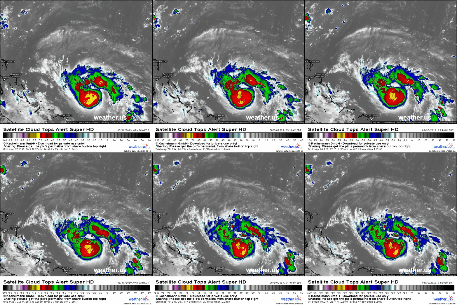
Satellite imagery early this morning shows a system that’s improving in many ways, but still struggling somewhat from the effects of dry air and wind shear. Hurricane hunter planes flying through the storm over the past few days have reported a double eyewall structure which indicates that the storm isn’t nearly as organized/efficient as it would like to be. The reason for that is likely a little bit of dry air trying to sneak into the storm’s southeastern side (note the break in the clouds SE/E of the center in the imagery above) as well as some continued southwesterly shear from the upper level low now moving into the Bahamas.
The environment will only become more favorable for intensification as the storm turns towards the west today. While there is some uncertainty regarding what exactly Dorian’s maximum intensity will be, the differences in possible outcomes (high end category three vs low end category four) are not worth spending too much time on. This discussion will focus primarily on the track forecast which is much more uncertain. It will involve some technical discussion, but my hope is that if you read through it carefully, I’ll have done a sufficiently good job explaining myself that you’ll have a more complete understanding of what’s going on than if I just said “we don’t know where it’s going to go.”
I’m going to be relying heavily on EPS ensemble data for this discussion. What’s an ensemble? The quick version is that it’s a way of accounting for our incomplete knowledge of what the atmosphere is doing right now (known as initial conditions) by running the same model with a bunch of slightly different guesses regarding what’s happening right now. The output is then a good way of figuring out how uncertain different elements of a forecast are.
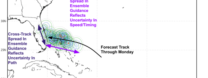
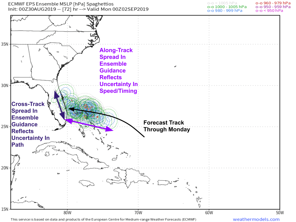
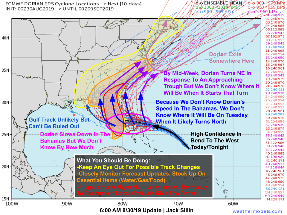
There are two main types of uncertainty I’ll be talking about: cross-track and along-track. Both are shown in the forecast map below.
Cross-track spread in ensemble members means that we know how fast the storm is moving, but we don’t know exactly in which direction it’s going. This is the uncertainty we’re most accustomed to seeing. Along-track spread in ensemble members means that we know the direction the storm is going, but we don’t know how fast it’s getting there. That’s the type of uncertainty that we’re dealing with regarding Dorian. Of course we don’t know exactly the direction the storm will go, but we have a pretty good idea. It turns west today/tonight then keeps going west until it arrives in Florida. The problem is that we don’t know how far the storm will have made it along that path at a given time. Map via weathermodels.com.
This makes the long term track forecast really hard because there’s a point (Monday night) where we really need to know how far west Dorian has made it.
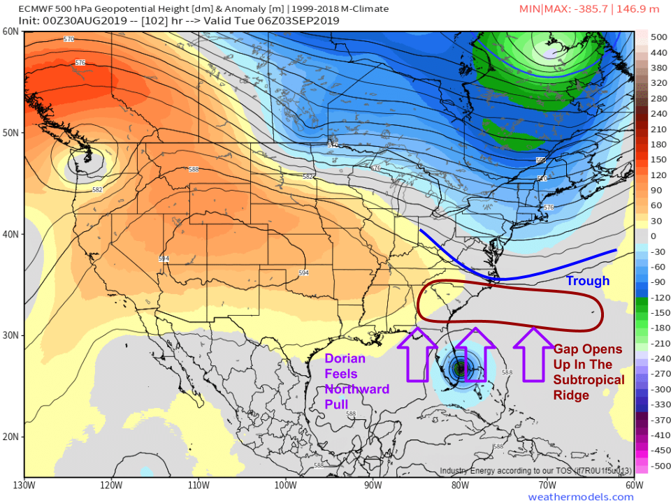
On Monday night, the subtropical ridge that has been steering the storm westward will be falling apart due to the arrival of some upper level energy from the polar jet stream (the trough on the map above). This means that Dorian will begin to turn northward into that gap in the ridge. Map via weathermodels.com.
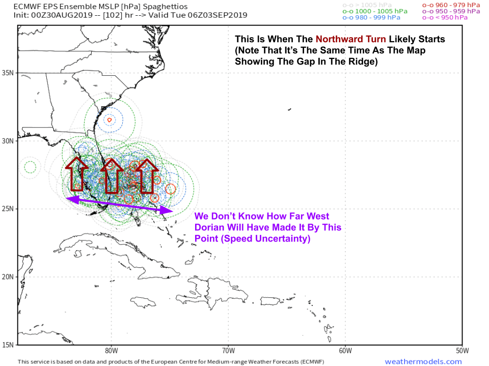 Which longitude (i.e. how far west) that turn happens will make a big difference for Florida. The only way we can answer that question is by knowing how far west Dorian will have made it by Monday night, which we can’t do without knowing the storm’s forward motion (or lack thereof) through the Bahamas. Here’s the range of possible outcomes for where the storm might be at the time of the northward turn. Discounting extreme outliers over the Gulf of Mexico and near SC, you can see that the storm could either be emerging into the Western Gulf, somewhere over the Florida Peninsula, or as far east as the Northeastern Bahamas. Map via weathermodels.com.
This brings us to this morning’s spaghetti plot which shows a wide range of possible outcomes for the eventual track of Dorian.
If the storm is still in the Eastern Bahamas when it turns north, it will recurve without ever hitting Florida. While this is not currently expected and you should not plan for it, know that it is possible. If the storm is located near Miami when it turns, it will scrape the East Coast of Florida with hurricane force winds, torrential rain, and storm surge. If the storm has already made landfall, it will bring dangerous winds and surge along with torrential rain to the entire Florida Peninsula. The final option, though considerably less likely, is that the storm will already be in the Gulf of Mexico at that point, in which case the Florida Panhandle would need to worry about direct impacts. Map via weathermodels.com.
By the middle of next week, Dorian will be starting a turn to the northeast as it begins interacting with the mid-latitude jet stream. How strong the storm will be at that point is unknown, as is its exact track and timing. Regardless, coastal parts of South Carolina, North Carolina, and Virginia need to start thinking about the possibility that Dorian brings strong winds, heavy rain, and storm surge at some point next week. I will be advising my family in these areas to pick up some extra non-perishable food, water, and batteries this weekend before stores start to run out as they have in Florida.
I will have more updates on twitter through the rest of the day today. You can follow us at @WeatherdotUS and @JackSillin. My next blog update will likely be this time tomorrow.
You can keep track of Dorian on your own timetable by using the tools we have at weathermodels.com (all the model maps you see in this post plus many more) and weather.us (GOES-East satellite imagery, free model data, tools to see the range of possible rain/wind outcomes in your town).
-Jack


Jack, great analysis and grateful to you for sharing your impressive talents. we’ll all hope the roof stays on!