Hours ‘Til A Nor’Easter
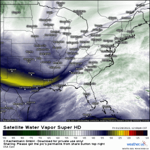
Well, the pieces are moving and our storm is pulling itself together as I write this. In fact, it’s rather evident via water vapor imagery:
From the northern stream shortwave moving toward the southern shortwave to the developing low off the southeast coast – it’s all coming together.
The forecast hasn’t really changed from what was discussed in yesterday’s blog. The only change worth noting is that the GFS finally caved to the ECMWF in the 00z run and agreed on a slightly further west storm.
All this means is that it will be more of a direct hit on the New England coast rather than a glancing blow.
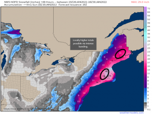
So let’s talk snowfall totals.
I like to use the NWS NDFD for snowfall predictions. The folks at the NWS put a lot of effort into their forecasts and they know their forecast area much better than I do.
I’m a southerner and forecasting snow amounts is NOT my strength. Forecasting snow in East Tennessee basically consists of two factors: 1. Will the cold air be here/get here fast enough? and 2. Will the elevations gobble up the moisture before it can make it to the valley? My point is – I trust the NWS forecast accumulations much more than any snow map I might make for unfamiliar terrain.
That said, I did add two areas of potentially/locally higher totals. Intense banding with snowfall rates in excess of 3 to 4 inches an hour could lead to greatly enhanced totals in these areas. Of course, this will depend on where the banding actually sets up, but looking at the modeled frontogenesis, these two areas stand a decent chance of receiving that band.
Two things to just sort of keep in the back of your mind as we move forward:
A dry slot will exist in this storm. Should it track over land, locally decreased totals will be possible.
In addition, any wiggle in track could make a big difference in accumulation on the western edges. A wiggle west will push heavier accumulations further into the interior northeast while a wiggle east could leave those in the cut-off zone without much at all. The accumulation gradient is likely to be rather sharp and may bring a surprise or two in the form of more than forecast or less than forecast.
Other hazards mentioned in yesterday’s blog (wind, surge, waves) still exist as well. Blizzard warnings have been added for most of the coast from the Delmarva through Northeastern Maine.
Requirements for blizzard conditions:
- sustained or frequent wind gusts of at least 35 mph
- visibilities of less than 1/4 mi
- blowing snow
- all of the above must be present for 3+ hours
Snow does not have to actually be falling for blizzard conditions to be present, merely blowing around.
Get the supplies you need tonight and get home. Prepare to be at home at least through the weekend, especially if you’re expecting over a foot of snow. Conditions won’t improve much after the snowfall ends as it remain cold.
Check out yesterday’s blog for specific fun ways to track our nor’easter as it bombs out. Or, just go visit https://weather.us/observations and play around with the parameters. There are many data stations, both onshore and offshore, recording real time observations as the storm moves up the coast. And remember, these maps are interactive! You can zoom in on a specific location and get more info (pressure trends, wave height trends, etc.) from a specific station by clicking on it.


