Bombs Away!
Here we are less than 36 hours out from what is no doubt going to be an impactful event for parts of New England. Normally by this point we’d have a forecast that was relatively solid. Unfortunately, our two “main” models show significant discrepancies in track.
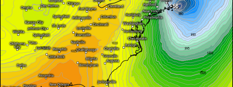
These track differences show up really well in the Total Snowfall maps:
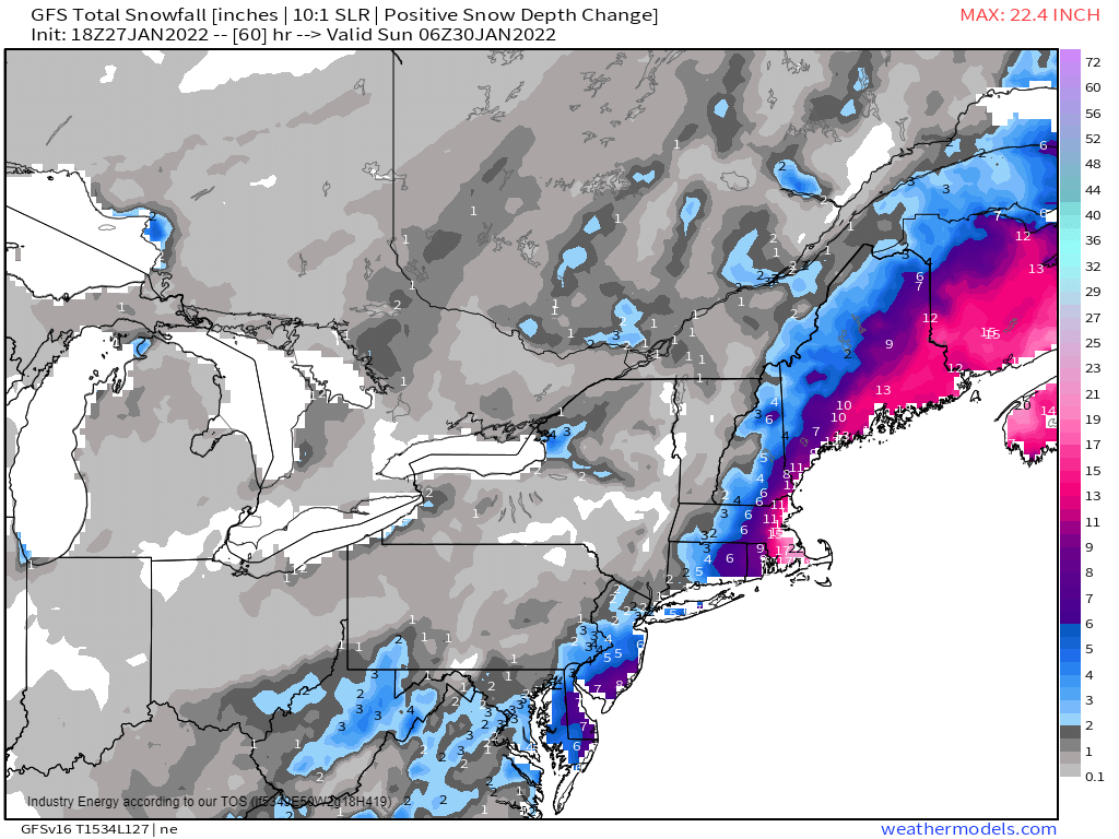
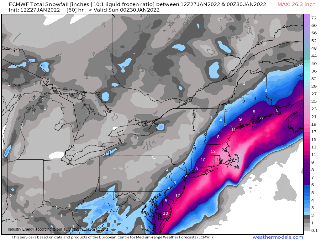
Exact totals aside, its rather obvious that the GFS (left) still supports a low further offshore while the ECMWF (right) supports a closer low. Neither has been willing to budge from their solution.
Ultimately, unless a consensus is reached during the 00Z runs later tonight, it’s going to come down to simply relying on observations – and comparing them to forecasts – to figure out which model was closer to the correct solution.
I mentioned in Tuesday’s blog that the disturbances needed to come together in the right way to create this storm. We can monitor that through water vapor imagery.
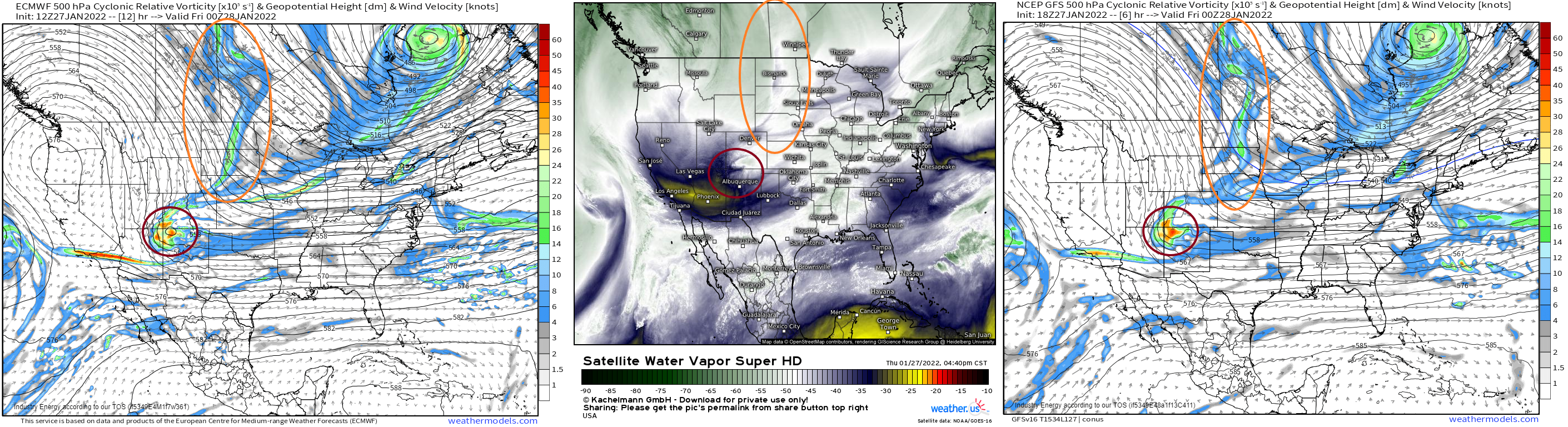
A couple of key features on the vorticity map are visible on water vapor imagery. Through comparison we can see that it is evolving generally as modeled up to this specific time period, though maybe just slightly more like as the ECMWF suggested than the GFS in a few minor ways.
Again, this will be a good comparison to make periodically to see if it’s leaning one way or another, assuming neither model budges off their solution.
Track differences aside, this storm is likely to “bomb out” and become a rather deep low.
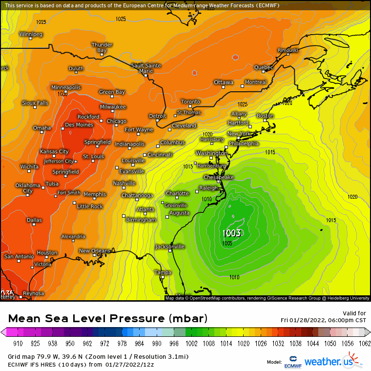
Model guidance takes it from a weak ~1003 mb low at 6 pm Friday to an impressive, powerful ~966 mb low at 6 pm Saturday. That’s a change of roughly 37 mb in 24 hours, which greatly exceeds the rapid intensification threshold of 24 mb in 24 hours.
Heavy snow and it’s exact location notwithstanding, this storm is going to have some far-reaching effects.
Wind-Driven Hazards

An intense pressure gradient created by the deepening low will produce strong winds. Hurricane force gusts are possible offshore. Tropical storm force gusts are possible onshore, with some approaching hurricane force in the more exposed areas of the islands and Cape Cod.
These winds will be creating an onshore push of water that may cause coastal flooding, especially if the peak “surge” coincides with local high tide.
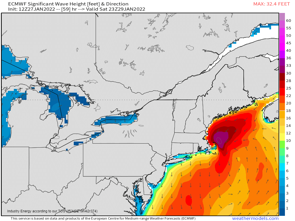
Strong winds over water also create large waves. Wave heights of up to 30 ft are possible offshore while lesser, but still larger-than-average, waves will contribute to beach erosion at the coast.
Snowfall
As for snow, this storm has the potential to drop roughly 2 ft of snow over part of coastal New England.
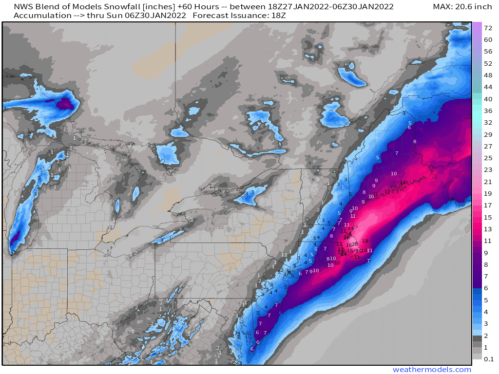
Using the National Blend of Models, which is essentially all the models’ solutions averaged together to get a single solution, that jackpot zone seems to be somewhere in Eastern Massachusetts. This exact spot will likely wiggle around some in the next day or so as will areas of lesser or higher totals as the models hone in on the final forecast. We can revisit this issue in 24 hours in tomorrow’s blog and discuss how things have changed.
Either way, heavy snow is likely for the New England coast with sharply decreasing totals as you move inland. Add in the forecast wind gusts and it’s likely that the criteria for a blizzard will be met at some point on Saturday.
I’m going to add links to some fun ways to track parts of this storm as we move through the day Friday/Saturday.
For pressure:
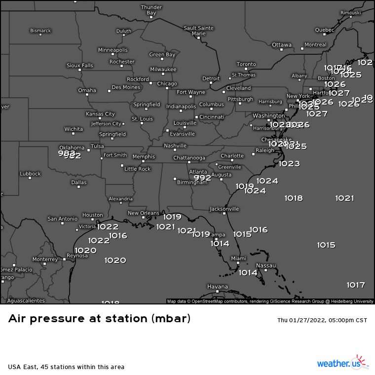
The “Air Pressure at Station” parameter in the Observation section has info for quite a few offshore stations. These will likely see pressure drops as the storm passes nearby. We may even get lucky enough to get one near the center during the peak.
Find it here: https://weather.us/observations/usa-east/air-pressure-station/20220127-2300z.html
For wave heights:
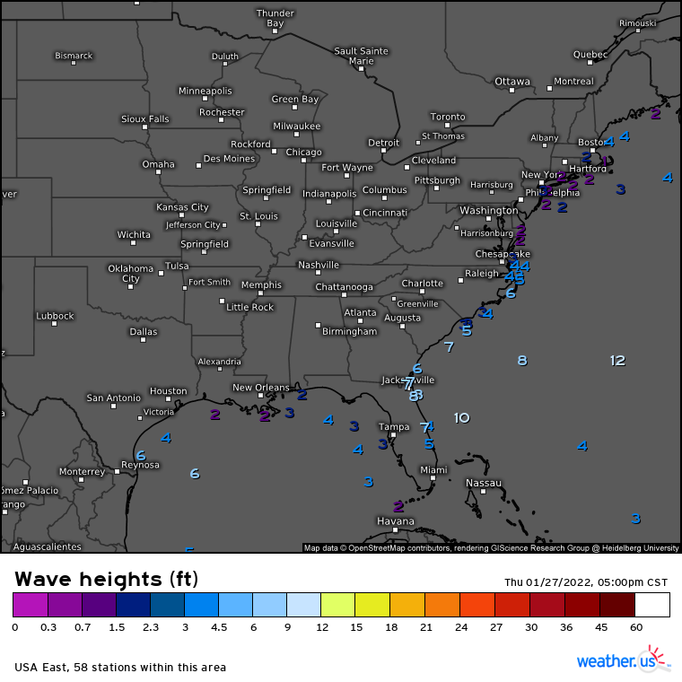
The wave heights parameter uses the same offshore sites and measures, well, the wave heights. Check back often to see how high the seas get as the low deepens.
Find it here: https://weather.us/observations/usa-east/wave-heights-ft/20220127-2300z.html
Wind
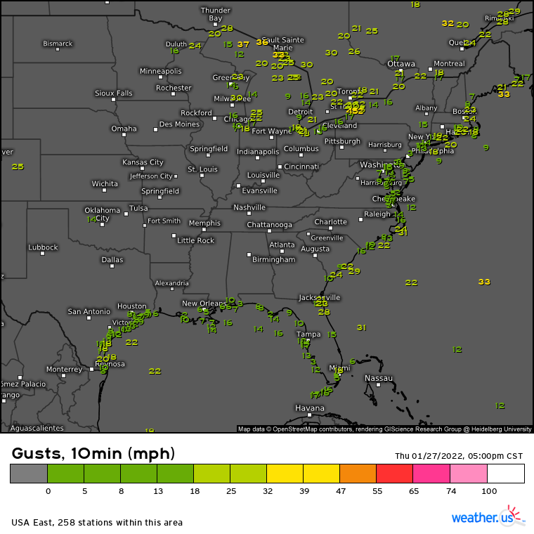
Plenty of stations to watch both onshore and offshore for wind gusts. This specific parameter is updated every 10 mins with current gusts.
Find it here: https://weather.us/observations/usa-east/gusts-10min-mph/20220127-2300z.html
Look for an update on the snow situation via blog tomorrow afternoon/evening!
About the author

Meghan Gulledge
Meteorologist - Mississippi State '22 Writer for Weather.us and Weathermodels.com. Focused on Weather Communication. BoyMom x1, CatMom x5. Twitter: @MegGulledgeWX