Historic Snowy Pattern Continues For Seattle And Surrounding Coastal Washington
Hello everyone!
Our focus will be on the West Coast today where a remarkable pattern is set to continue for at least another week in Seattle. The city saw several inches of snow on Monday, which by itself was an unusual event. The storm arriving today will likely exceed Monday’s by a factor of two, with the snowy pattern continuing after that. This post will mostly focus on tonight’s system, but will also briefly take a look at the larger pattern towards the end.
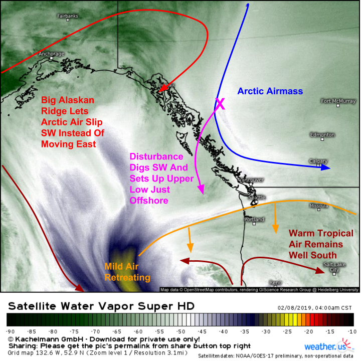
Here’s a look at the major players coming together for tonight’s storm. A big ridge is building into Alaska, and is resulting in northeasterly flow across British Columbia. That northeasterly flow is taking Arctic air from the Northwest Territories and bringing it SW towards the Pacific coast instead of its usual SE path towards the Great Lakes. A strong disturbance marks the leading edge of that cold air, and it too is digging SW. As it hits the Pacific, it will drive the development of a strong upper level low which will be responsible for strong lifting and thus heavy precipitation. Meanwhile to the south, a strong storm off California has redirected the subtropical jet and its mild air down in California. This will allow snow to fall in low elevation areas that usually see rain in more typical events.
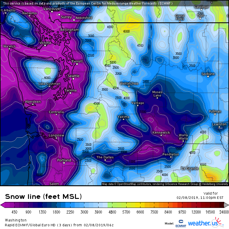
Our snow line product from the ECMWF shows an airmass cold enough to let snow fall to the surface across the entire state of Washington except for a small area in the far SE part of the state. Note that the higher values that might indicate warmer air are co-located with the higher terrain of the Olympics and Cascades. So the model is saying you’d have to go up 4,000 feet to see snow in those areas, but the ground is also 4,000 feet+ so snow will still fall all the way to the ground.
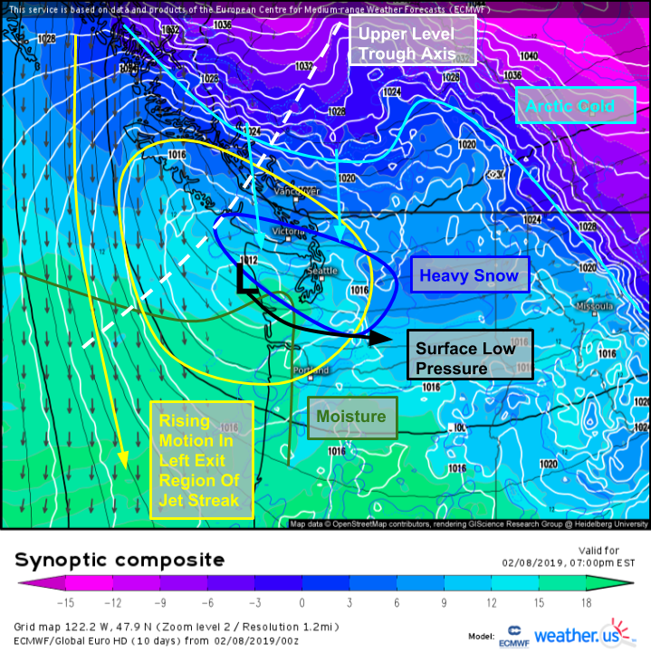
Here’s a closer look at the dynamics that will bring the heavy snow this evening. The upper level trough and its accompanying jet streak will provide large scale lifting across the Pacific Northwest. Surface low pressure will move ashore in SE Washington, and lifting will be focused just to the north of its track. Heavy snow is thus expected from the tip of the Olympic peninsula down into the Central/Southern Cascades. Snow rates of 1-2″ per hour are likely in this band which will be present during the evening commute. Be ready for substantial delays!
Here’s a shot of the ECMWF model’s forecast for the storm this evening. The map is valid at 6 PM Pacific Time, right during the evening commute. Note the band of very heavy snow right over Seattle, with steady snow present across the rest of the western half of the state. Map via weathermodels.com.
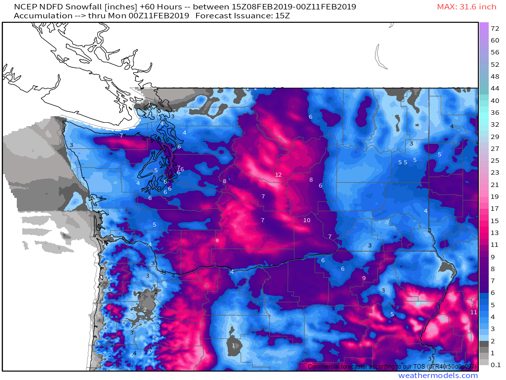
Here’s a look at expected snow totals from this storm. The heaviest snow will of course be in the higher terrain, but lower elevations near Puget Sound are in for a solid 4-8″ storm. Downtown Seattle is likely to see right around 6″ of snow, with a little more as you head just north of town. Lighter amounts will be found in the lower elevations close to the low’s track including the coastline especially in the southeastern part of the state. Northern Oregon will also see snow from this event, but it will be more elevation dependent than the snow in Washington because the low will be tracking more overhead than to the south. Map via weathermodels.com.
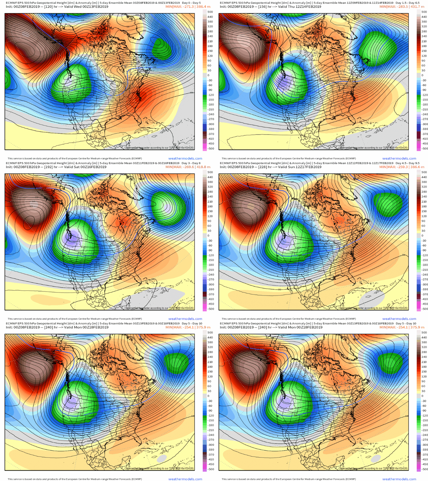
So what about the pattern? Remember at the beginning when I looked at WV satellite imagery, I mentioned how important the Alaskan ridge was in getting cold air to dig SW towards Seattle as opposed to sliding SE towards the Great Lakes. That strong Alaskan ridge doesn’t appear to go anywhere in the next 7-10 days, and the strong NNE flow on its eastern periphery will continue to deliver cold air and Arctic disturbances to the Pacific Northwest. As a result, this is almost certainly not the last time we’ll be talking about Seattle snow this month. GIF via weathermodels.com.
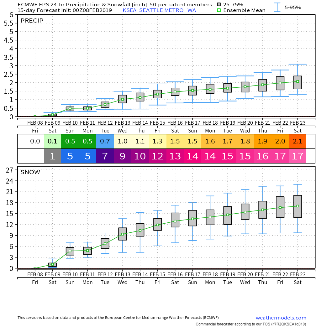
Here’s the EPS’s forecast for precip in Seattle over the next couple weeks via weathermodels.com. Don’t take the snowfall numbers too seriously, but it is noteworthy that of the 2.1″ of liquid equivalent forecast to fall between now and 2/23, 1.7 of it is forecast to fall as snow by the ensemble system. Whether or not Seattle actually sees a foot and a half of snow over the next two weeks remains to be seen, but the pattern is supportive and having a robust ensemble signal is certainly a promising sign. Time to dust off those snow shovels and winter driving skills!
-Jack
