Heavy Rains Continue To Cause Flooding Issues In Arkansas As Snow Falls In The Lowlands Of The Pacific Northwest
Hello everyone!
We have another day of fairly active weather on tap as our high amplitude pattern continues. On the warm side of the US, heavy rain is continuing to fall across parts of Arkansas where flooding will remain a concern today. On the cool side of the US, snow will fall all the way to sea level in the Seattle area as Pacific moisture runs into a very deep cold airmass in place under a large upper level trough. In between the warm and the cold will be our third area of active weather to watch which will bring rain, snow, and ice to parts of the Northeast.
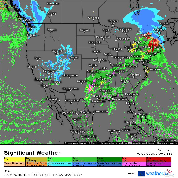
Here’s the ECMWF’s overview map showing several areas of active weather today. We have the messy mixed precip system in New England/New York, we have the heavy rain in Arkansas, we have some strong thunderstorms in Texas, areas of snow in the Rockies, and finally our flakes in Seattle. I’ll briefly dig into some of the more impactful weather elements here, and leave links to resources on weather.us you can use to find out more about each of these systems on your own if you’re interested.
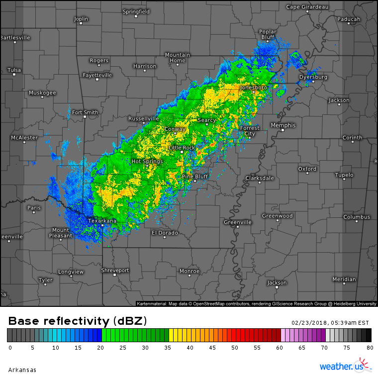
HD radar imagery shows a band of heavy rain continuing to park itself over Central Arkansas. The southern edge of this band features pockets of very heavy rain associated with thunderstorms, while the northern edge of the band is slightly less intense, but much steadier. You can click the radar maps on our site to zoom into county level which will let you take a detailed look at any individual storm cell. You can also use the blue buttons above the radar map to select different radar options such as velocity, storm tracking, or lightning analysis.
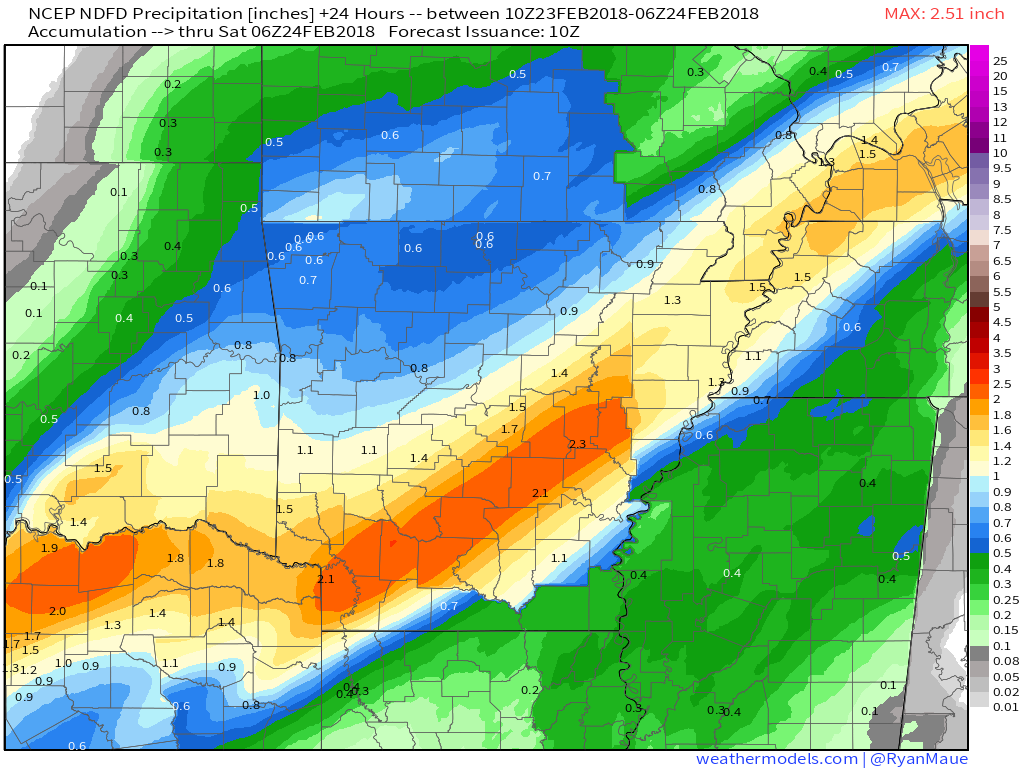
This is a composite of the precipitation forecasts from each of the NWS local Weather Forecast Offices (WFO’s) in the Arkansas area. The sharp lines along state/county borders are a result of neighboring WFO’s disagreeing slightly on the exact forecast, though it’s important to note that the general idea remains the same with a wide area of 1-3″ expected from NE Texas up through the Memphis area, which is the same region that’s been seeing heavy rain for days now. It’s also important to note that these are “area averaged” rainfall totals, and amounts under individual intense cells will locally exceed these totals, while areas that see the intense cells barely miss may fall short of these totals. It’s impossible to pin down exact storm cell movement until the cells actually form and begin moving, and even then it’s hard to tell whether a storm will intensify, weaken, or change course until it happens.
Map from weathermodels.com.
One final round of very heavy rain is expected in this region tomorrow before a drying trend emerges. I will cover that, along with tomorrow’s widespread severe weather threat and snow farther north, in a separate blog post this afternoon.
On the colder side of our high amplitude pattern, snow is expected all the way to sea level in Seattle today.
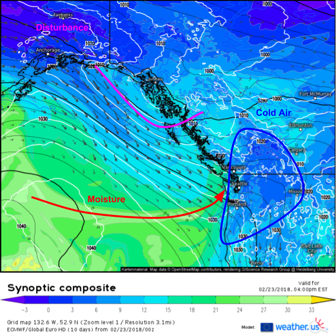
The ECMWF’s synoptic composite map shows a perfect setup for lowland Seattle snow, with very cold air locked in place thanks to high pressuree, a stream of warm moist air strong enough to support precipitation, but not so strong it overpowers the cold, and a disturbance diving in from Alaska to help provide lift for precipitation, without all the warm air typically associated with Pacific disturbances. For more on the ECMWF’s synoptic composite product and how to use it, check out this video. This map was created with our custom zoom tool, which I explain in this video.
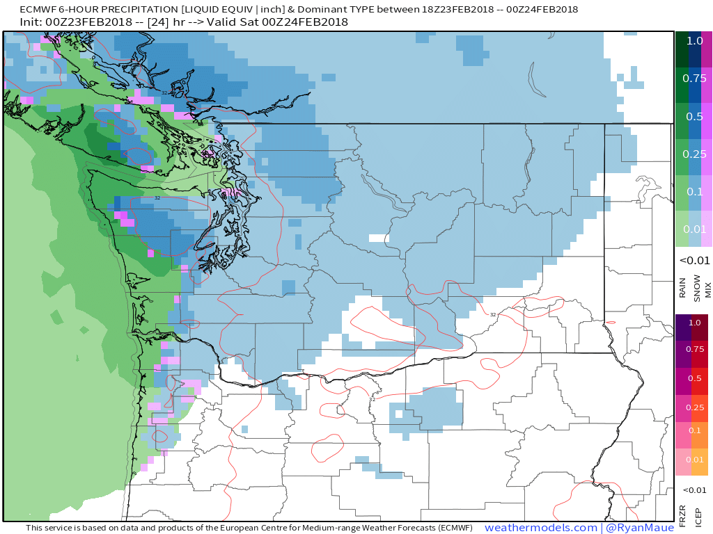
Here’s the ECMWF’s precipitation type forecast for this evening in the Seattle area showing flakes falling all the way down to Puget Sound. The heavier snow that stands a chance of accumulating more than an inch or so will remain confined to the typically favored higher elevations of the Olympics and Cascades, but even just seeing flakes in the air is an unusual occurrance in the lowlands of Washington State. Snow will move off to the south and east tonight as that disturbance moves towards the Central Rockies.
Map from weathermodels.com.
Farther to the east, our third area of active weather will reside right at the boundary between warmth and cold.
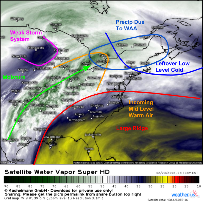
GOES-East WV satellite imagery (what’s that?) shows a number of features getting ready to fuel some Warm Air Advection driven precipitation in parts of New York and New England today. There’s our large ridge over the Southeast, some low level cold air leftover from yesterday’s snowy system that knocked that ridge back to the south, and we have a storm system located roughly over Minneapolis. Warm air is flowing north through the atmosphere on southwest flow ahead of that storm system and on the NW periphery of the ridge. That warm air is also accompanied by moisture, which is responsible for those heavy rains in Arkansas. As that warm air is transported (advected) over the low level cold air in New England, precipitation will develop due to the warm moist air being forced to rise up and over the low level cold. Depending on just how cold the surface is (above or below 32F) and how much warm air (enough to cause temps to rise above freezing or not), that precipitation could fall as rain, freezing rain, sleet, or snow.
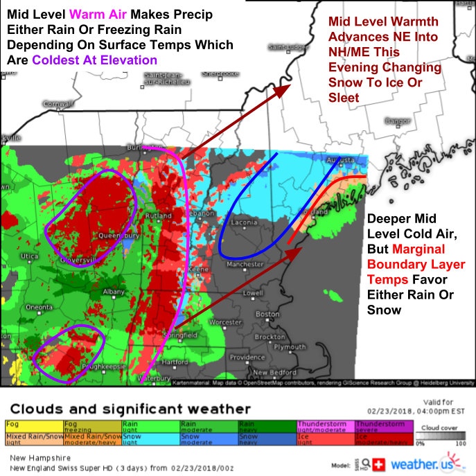
Here’s a look at our Swiss Super HD model’s forecast for precipitation type this evening in the NY/New England area. You can click into the map on our site to zoom in to county level for an even closer look at your forecast. Notice how places farther south and west that see deeper mid level cold air are either looking at rain or freezing rain depending on surface temps, while areas farther NE and deeper into the cold airmass are looking at either rain or snow depending on surface temps. As that mid level warmth races NE, interior parts of Maine that start as snow will see a transition to light icing before precip tapers off tonight. No significant snow or ice accumulations are expected, but areas that see freezing rain will also see very slick roads.
I will have another update here this afternoon with details on a very active weather day across parts of the Central US tomorrow. Will take a look at an intense flash flood threat, widespread severe storms, and a swath of potentially heavy snow.
Meanwhile, you can get all the data you need to answer your lingering forecast questions at weather.us.
If you’re interested in my thoughts on the weather in NH/ME: https://forecasterjack.com/2018/02/23/cooler-today-with-a-return-to-mixed-precipitation/
-Jack
