Harvey Continues To Dump Massive Rainfall, PTC 10 Moves NE, 93L Looms In The Background
Hello everyone!
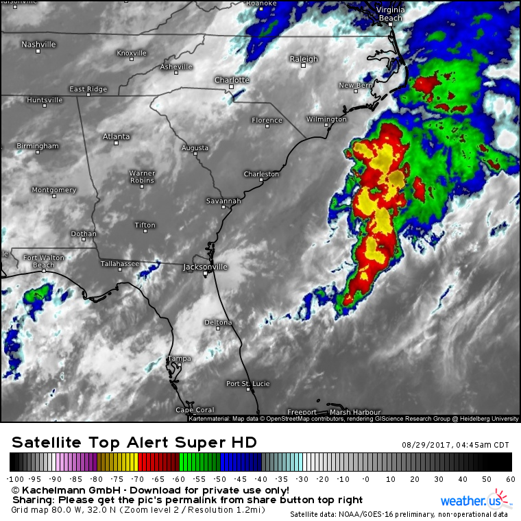
Our trio of topically related systems continues to cause problems today. Harvey is the number one threat with torrential rans still ongoing across the Houston area. Those downpours are moving east, ever so slowly, and will begin to impact the New Orleans area today, where some flooding is certainly possible. PTC 10 will sweep through the Carolinas today with high winds, heavy rains, and rough surf. It almost certainly won’t get designated as TS Irma, however, due to high wind shear from Harvey’s outflow. Farther east, over the Cape Verde islands off the west coast of Africa, a much greater threat looms with a cluster of showers and thunderstorms that is likely to develop into a major hurricane in the coming week. I’ll have details on one of the overlooked patterns that may make this system a threat to the East Coast.
But first, we’ll start with Harvey.
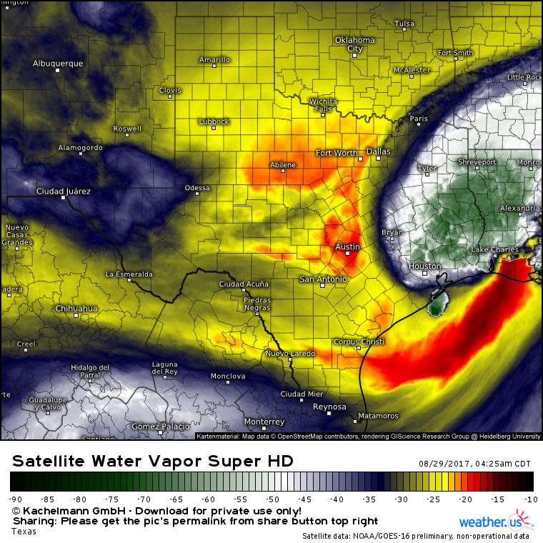
GOES-16 satellite imagery shows the deepest moisture associated with Harvey now moving off to the northeast of the downtown Houston area. That doesn’t mean that it will stop raining, it just means that the worst will likely shift east. However, when you’ve already seen the 42″ of rain that Houston has, any additional raindrop is far from helpful. This same trend is visible on our HD radar which shows moderate rain in Houston with much heavier bands to the east. As the system tries to wrap itself up a little bit, some of those bands could try to pivot towards the Houston region, but thankfully, that’s far from a sure bet.
While heavy rain bands are shifting away from Houston, they are shifting towards Louisiana.
Those heavy rain bands are already ongoing across Louisiana as seen by our HD radar products, and they will continue throughout the day. Heavy rains will cause flooding, though thankfully not of the extreme magnitude as we saw in Houston. Additionally, tornadoes are expected to pose a threat across Southern Louisiana as some of those stronger cells move onshore. An additional 2-4 inches is expected in the New Orleans area with higher amounts back towards Shreveport and Port Arthur. Heavy rain was ongoing in these areas yesterday and last night so storm total rainfall is likely to be in the 6-12″ range across these areas. While that’s a far cry from the 40″+ in Houston, it’s still more than enough to cause some issues especially in the low lying spots most susceptible to flooding.
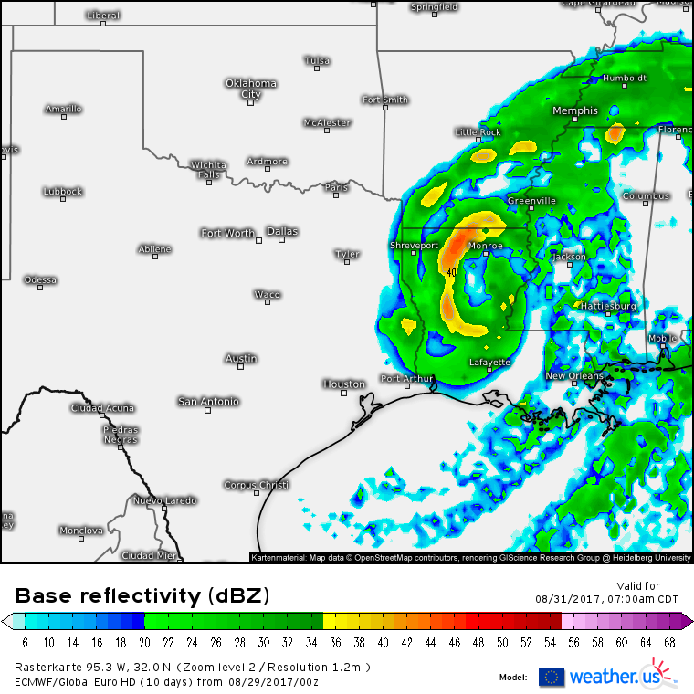
When will we finally be done with Harvey’s nightmare? In the Houston area, by Thursday morning. ECMWF guidance has continued to speed up Harvey’s departure which is fantastic news for the Houston area. The system will bring some moderate/heavy rains to parts of Arkansas and the Ohio Valley but it will be gaining momentum and the faster northeastward movement will preclude any devastating flooding like we’ve seen in the Houston area. The system will merge with a cold front this weekend when it could bring some rainfall to areas as far away as New England.
Our next tropically-related system is PTC 10.
I say “tropically-related” because PTC 10 isn’t actually a tropical cyclone, nor will it be. It’s much more of a winter-like system that will feed off the temperature gradient between the warm Gulf Stream waters and fall-like air over New England. Nevertheless, the impacts across the Carolinas will remain more or less the same. The only real impact from the lack of tropical development will be a reduction in expected rainfall. While the developing system will bring some heavy rains, the lack of a tropical rainfall situation will mean that lighter rainfall amounts are expected, over the Carolinas.
Here’s the latest ECMWF forecast. Notice how the heavy rains are focused right along the coast and to the north of the system. The rainfall distribution will be much more extratropical than tropical as the system develops today. That will also help some of the moisture get farther north. Notice forecasts for light to moderate rain as far north as NYC and Southern New England.
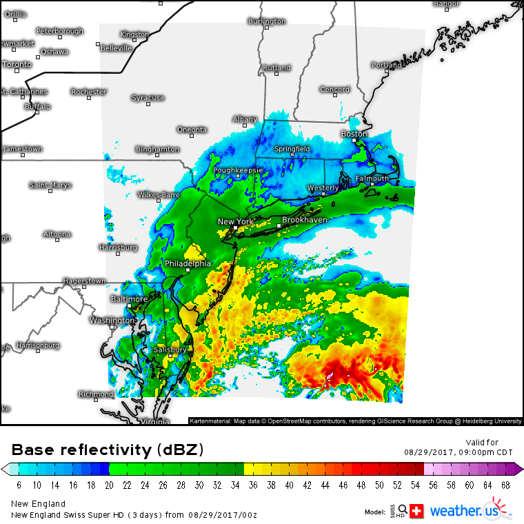
The Swiss Super HD model shows light to moderate rain over NYC and SNE tonight.
If this was a purely tropical system with the heaviest rains clustered close to its center, the NYC/SNE area would remain dry. That won’t be the case with PTC 10 as it races NE. Despite the changes in the structure of the storm, gusty winds are still forecast along the coast in addition to high surf. The system will rapidly intensify as it moves offshore tonight with winds reaching hurricane force well offshore by tomorrow.
As Harvey rains itself out over the Ohio Valley and PTC 10 rapidly races offshore, attention will shift over towards the far Eastern Atlantic where another tropical cyclone is likely to develop this week.
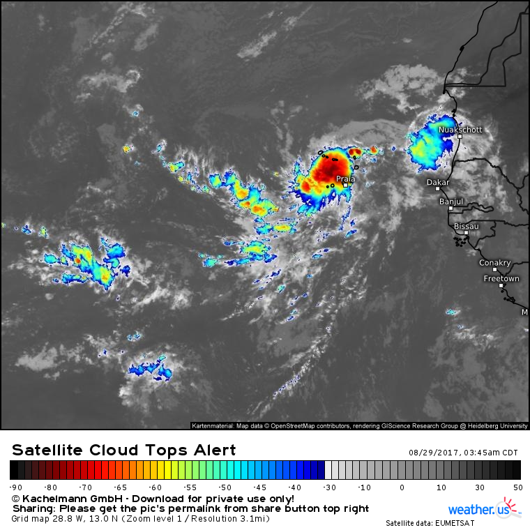
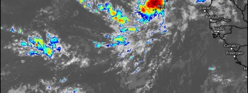
Invest 93L is looking very good on satellite this morning. Deep convection has developed and is persisting over the center of the storm which is becoming consolidated over the Cape Verde islands. Distinct outflow channels are evident to the north, south, and west of the system and there’s little dry air or wind shear in the area. This favorable environment should let 93L become TS Irma in the next few days.
Where will 93L track and how strong will it get?
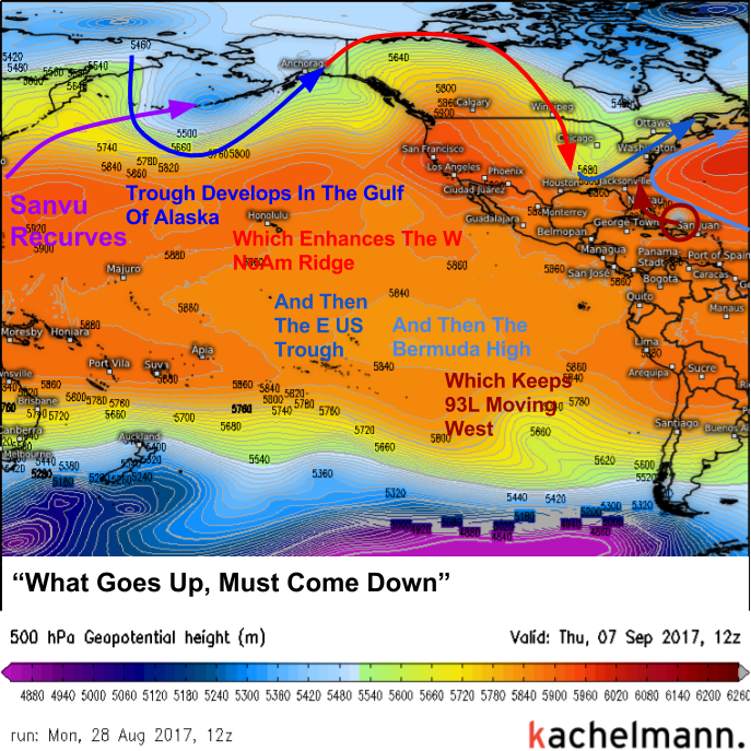
The second question is the easier of the two. The environment is very favorable for strengthening of the system and the favorable environment is expected to continue through the week. There is nothing stopping this system from becoming a hurricane as it tracks west across the Atlantic. Now where will it go? That’s a little trickier. I think the answer lies thousands of miles away from the system, all the way in the waters off the coast of Japan.
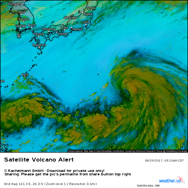
This tropical storm, named Sanvu, is expected to intensify into a typhoon this week. It will do this while moving north and then northeast well off the Japanese coast. As it does this, it will merge with a non-tropical cyclone that emerges off the Siberian coast. These systems will combine to create a very large low pressure system near Alaska. As we’re seeing with Harvey, tropical systems contain immense amounts of heat and moisture. With Harvey, that was important because it drove the flooding threat. With Sanvu, that’s important because as it transitions into an extratropical cyclone, it will alter the weather pattern across the entire Northern Hemisphere.
Basically, when you add tons of heat energy to the high latitudes over the North Pacific due to a typhoon recurving, it drives a very large ridge of warm high pressure up into Canada. What goes up, must come down, so a trough forms in the eastern US. In weather, the reverse is also true; what goes down must come up, therefore the Bermuda high will strengthen. That’s what we care about with regards to the 93L track forecast.
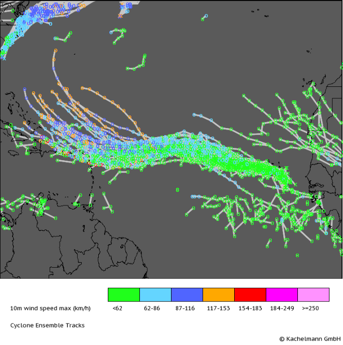
A stronger Bermuda high would let 93L move farther west before it can be scooped up by the East Coast trough. You can see the Bermuda high’s influence in this plot of EPS ensemble tracks for the storm. Notice how the storm will move WNW for the next several days. Once it reaches the middle of the Atlantic, it takes a turn towards the southwest. This is in response to the Bermuda high strengthening. You can see the tracks of the storm start to hook north at the tail end of the forecast as the potential system begins to feel the effects of the East Coast trough. Of course, there is still plenty of uncertainty as to exactly how the trough and the storm will interact, and those interactions will determine what, if any, impacts the US may see. Right now though, we do know that the pattern is all set for a tropical system, potentially a hurricane, to threaten the East Coast in 10-15 days. We will be watching closely, and you can too!
See the latest ECMWF model guidance for 93L (you can use the menus to the left of the image to navigate to other areas if you want to check out Sanvu for example).
I’ll be back this afternoon with more on Harvey, PTC 10, and 93L.
-Jack
