Gulf of Mexico Tropical Development Appears More Likely This Week
Hello everyone!
Back on Thursday, I mentioned that we might have a system to watch in the Gulf of Mexico for possible tropical development sometime this coming week. We’re still far from any definitive answers regarding whether such a system will actually develop, and how strong it might be or where it might go if it does turn into a tropical cyclone. That said, now that we’re around three days away from the system’s initial development and around five days away from when the system might start moving towards the US Gulf Coast, it’s time to take a closer look at what we might be able to expect from this system.
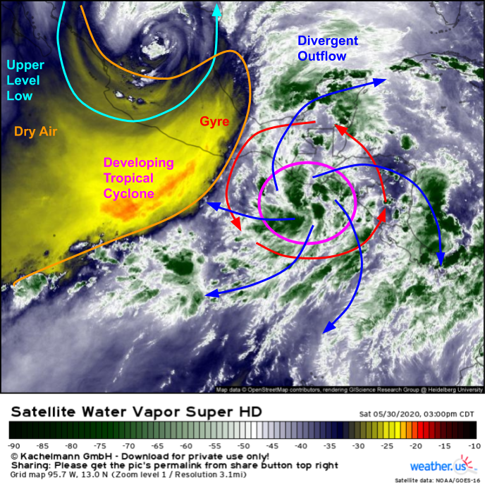
Satellite imagery this afternoon shows the developing gyre centered south of Guatemala. At the center of the gyre, an area of persistent thunderstorm activity is attempting to develop into a tropical cyclone. Currently, the National Hurricane Center gives this feature an 80% chance of developing into a tropical depression or storm in the next couple days before it makes landfall either in Guatemala or far southern Mexico. The system won’t have enough time to intensify into a wind-dangerous storm before landfall along the Pacific Coast of Central America, but it will dump a lot of rain, leading to flash flooding and mudslides. Regardless of the system’s short-term development chances, there’s no need to be concerned on the Atlantic side of Central America tomorrow or Monday.
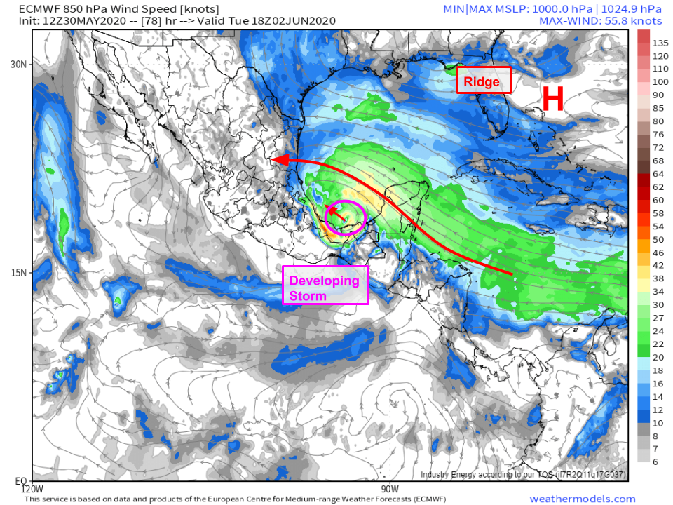
 On Tuesday, the gyre’s circulation will move north into the Bay of Campeche which is the southernmost portion of the Gulf of Mexico west of the Yucatan Peninsula. I’ve used the EPS ensemble mean 850mb wind forecast because it smooths out some of the noise in individual model/ensemble member depictions of the system’s circulation at this time. We don’t know exactly what the circulation will look like at this point in time. Could it be the remnant circulation of a tropical cyclone that moved onshore in Guatemala tomorrow? Could it be the broad gyre itself, without a focused center of circulation and associated cluster of showers and thunderstorms? Could it be a series of several smaller circulations (vort maxes) embedded within the larger gyre? All of those possibilities are still on the table, and which ends up actually occurring will play a huge role in any eventual US impacts. So already, a mere 72 hours into the forecast, we have a lot of unanswered questions.
 The first possibility, that the disturbance emerging in the Bay of Campeche on Tuesday will be the remnants of the tropical cyclone currently forming in the eastern Pacific, seems to be the most likely at this point. It’s shown by the ECMWF deterministic model (highlighted in the loop above) and a majority of the ECMWF ensembles. This scenario would allow for faster development of the system in the Gulf of Mexico beginning on Tuesday because instead of dealing with the very broad gyre circulation, there would be a consolidated center of circulation (if not at the surface, certainly a bit off the ground) around which the system could begin coalescing. In this scenario, a tropical depression or storm could form in the southern Gulf of Mexico as soon as Tuesday or Wednesday.
If the storm were to develop more quickly, it would find itself in a bit of a steering dilemma.
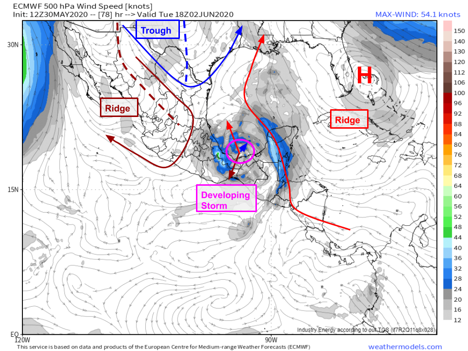 A look at forecast 500mb winds (close to the steering layer for a strong tropical storm or weak hurricane) shows three primary features responsible for steering our developing storm. The first is a trough over Texas. This feature wants to pull the system north/northeast, but it will exert only a relatively weak force on the storm because it’s located so far away. The two stronger steering features will be ridges on either side of the storm. The first, centered east of West Palm Beach Florida will try to push the storm north/northwest. The second, centered over Mexico, will attempt to push the storm towards the south/southwest. Given this three-way tug-of-war, it’s no surprise that confidence in the system’s track is quite low.
To add to the confusion, if the storm remains weak, it will be steered west/northwest by the ridge east of Florida, or possibly even southwest by the larger-scale gyre in which it will still be embedded (but doesn’t show up well on this map). This would send the system into the Mexican coast before it could gain much steam, and we would be forced to wait for the next disturbance to pinwheel around the gyre later next week before any tropical development could occur. This scenario is depicted by the operational ECMWF model and a few of its ensembles.
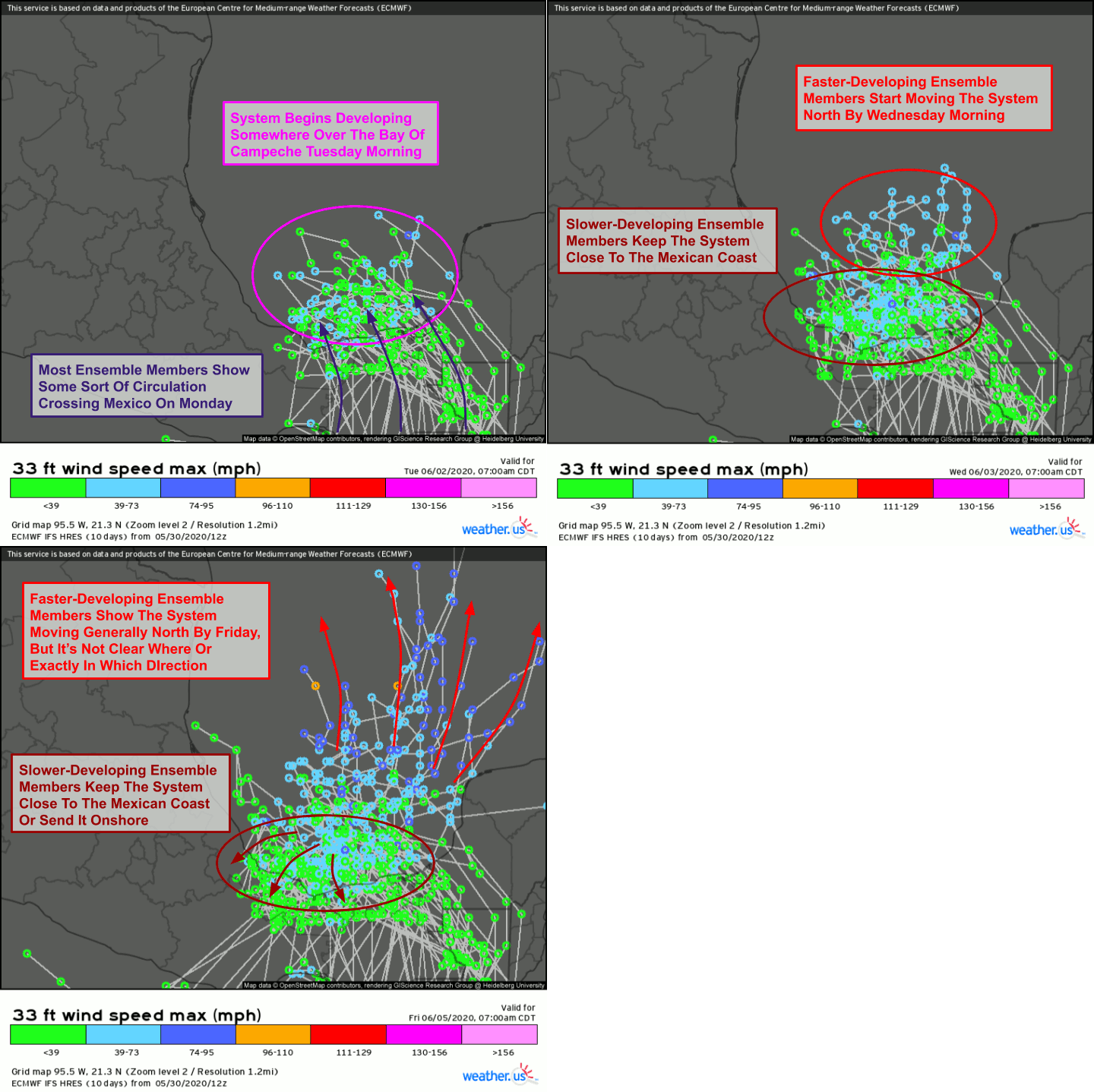
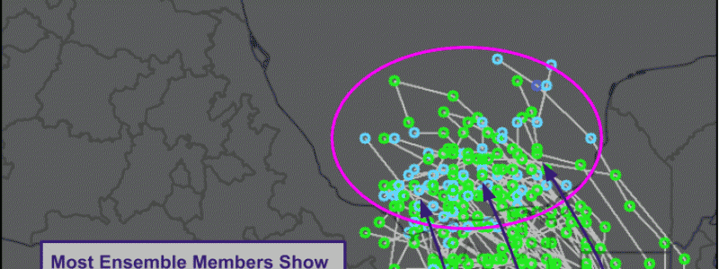
This dependence of track on intensity can be highlighted by plotting EPS ensemble member forecast tracks colored by maximum intensity. Note that the stronger members (light blue circles indicate forecasts showing tropical storm force winds) send the system north by Friday while the weaker members keep the system closer to the coast. Some of the weaker members send the system inland (where it would dissipate without access to warm water) while others keep it festering over the Bay of Campeche for a while before either moving onshore or north. Based on a quick count, roughly 30/51 ensemble members show some northward movement of the system either initially (by Friday) or a little later (by next Sunday). The Bay of Campeche is notorious for helping tropical cyclones spin up quickly (likely because of its shape) and the environment for intensification looks at least moderately favorable. Thus I’m leaning towards the stronger/faster-moving solution as of now.
Need a refresher on ensembles? Check out this post for an explanation of what ensembles are, how they work, and why they’re useful. Check out this tutorial video to learn how to use the ensemble storm track product I highlighted in the above animation.
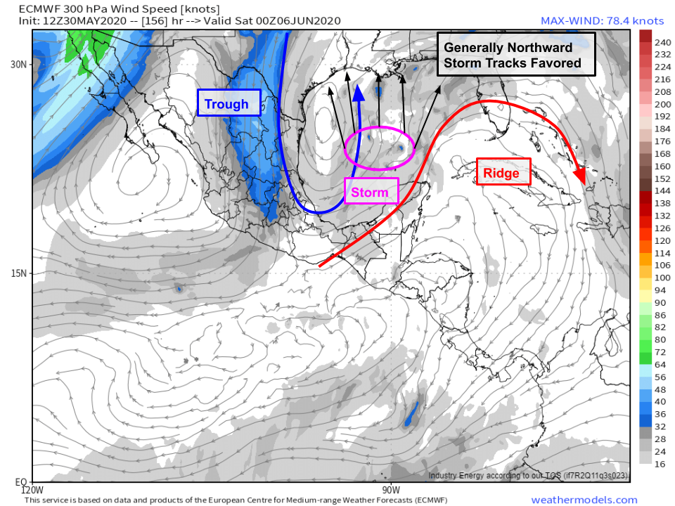
If that stronger/faster-moving solution were to occur, here’s what the steering flow would look like by Friday evening. Note that I’m using 300mb winds here which are not perfectly representative of the steering flow but would be a decent approximation for a lower-end hurricane. Either way, the map highlights the two key features that would be steering the system, so try not to focus too much on exactly where the wind vectors are pointing, and focus more on the bigger picture which is that southerly or southwesterly flow will be present in the vicinity of the storm between an upper-level trough east of Brownsville Texas and an upper-level ridge draped from the eastern Pacific through El-Salvador and Honduras towards Cuba. This flow will generally steer the system north, though the exact steering flow will depend on the storm’s exact location which, of course, is still to be determined.
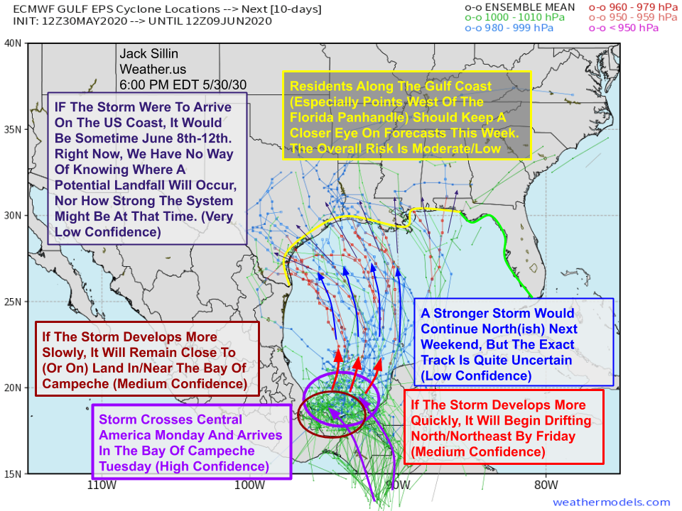
So what does the big picture look like summarized in one annotated spaghetti plot?
Here’s my best guess as of this evening. Overall, forecast confidence is still really low past Tuesday/Wednesday when the system will either fizzle out over southern Mexico or gain strength and start moving north through the Gulf of Mexico. Once we know what happens then, we’ll have a much better idea of what will happen next weekend and beyond. The message for residents along the Gulf Coast is pretty simple at the moment: start to pay a little closer attention to forecast information from the National Weather Service, National Hurricane Center, trusted local media, and trusted online sources. Make a habit of checking in on the forecast for this system once a day. That way you won’t be caught off-guard if this does become a system worth worrying about, but you also won’t be consumed by chatter about individual model runs that will be showing wildly inconsistent solutions over the coming week. There’s no need to be worried about this system yet, but it’s always a good idea to be prepared in case a storm (either this one or something else later this season) does show up at your doorstep. Hurricane Season officially kicks off in the Atlantic Basin on Monday and continues through November 30th.
I’ll have more updates here and on twitter @WeatherdotUS and @JackSillin in the days to come.
-Jack
