Florence Moving Westward Through The Open Atlantic, Will Threaten The Carolinas Next Week
Hello everyone!
Florence has been downgraded to a tropical storm, having lost a considerable amount of its strength over the past couple days. The storm has made its forecast turn to the west, having run into the upper level boundary discussed in yesterday’s update. This westward motion will continue through the next couple days, before the storm resumes gaining latitude later this weekend. By the middle of next week, the storm will most likely be approaching the Southeastern coastline, and could be quite strong as it does so. This update will break down some of the factors behind Florence’s forecast, as well as which parts of the coast are most at risk to see direct impacts.
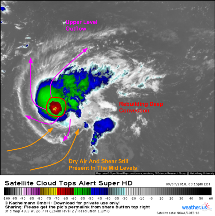
A quick look at satellite imagery this afternoon shows Florence continuing to struggle with dry air and shear in the mid levels, though not nearly as much as this morning. Some deep convection (aka strong thunderstorm activity) has rebuild near/just west of the center, and the storm’s upper level outflow channels remain intact.
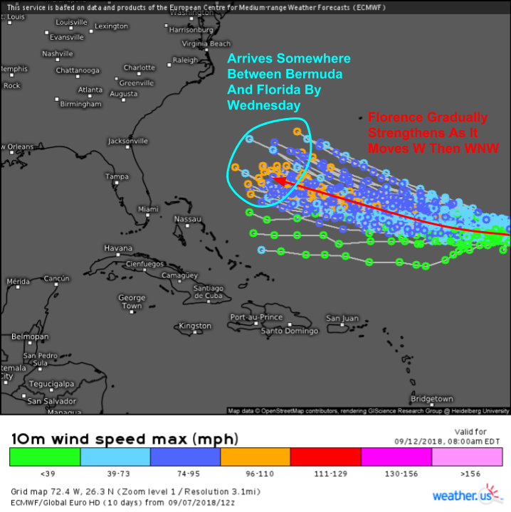
EPS ensembles are by far the most valuable tool available to keep an eye on Florence’s forecast. The 51 member ensemble provides a look at 51 possible outcomes that help quantify forecast uncertainty. Learn more about ensembles, and how to find that data at weather.us, in my video tutorial. The basic idea this map shows is that Florence will move west for the next couple days, before a turn to the WNW occurs this weekend. By Wednesday, the storm will be located somewhere between Florida and Bermuda, and will almost certainly have restrengthened into a hurricane.
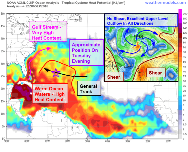
The map above highlights two general factors important to the intensity of tropical storms: ocean heat content and wind shear. Ocean heat content, which is the larger map, is basically a measure of fuel for hurricanes, and is very closely related to the temperature of the water. The warmer the water temperature, the more fuel is available for hurricanes. Notice how Florence is forecast to move from a low-fuel area towards a higher fuel area in the coming days. This will help set the stage for strengthening. Wind shear has been plaguing the storm for the past few days, and will continue to do so for at least the first part of this weekend. However, by Tuesday, shear will be relaxing and an upper level anticylone will establish itself overtop of Florence. This anticyclone will bring shear down near zero over the storm’s center, while also helping to establish ventilation channels in the upper levels. Hurricanes are giant heat engines, and no engine is able to work very well without exhaust. All that to say, Florence’s struggles with intensity are likely to come to an end as the storm moves into a much more favorable environment early this coming week.
Map via weathermodels.com.
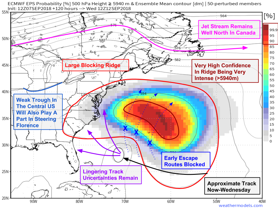
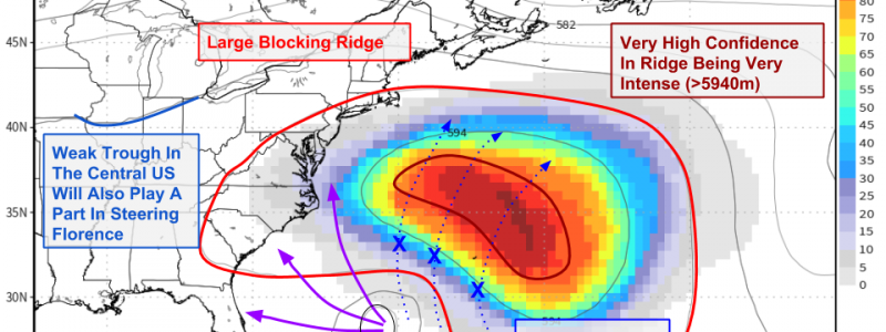
Here’s a look at the steering setup on Wednesday, which is when the spread in ensemble solutions really gets going. The biggest steering player next week will be a massive ridge of high pressure located to Florence’s northeast. This ridge will block the “escape routes” that typically allow storms in Florence’s position to recurve out to sea. Ensembles are locked on to this ridge, and the probability for it to become very strong (>5900m 500mb heights) is extremely high (notice the >99.9% probabilities). That ridge will keep Florence on a west-northwestward path through the middle part of next week. As Florence moves farther away from the ridge, the storm will begin to feel the influence of a weak trough located in the Central US. How Florence interacts with that trough will determine its exact track, and point of landfall. There’s still a chance, if that trough is stronger than forecast and the ridge is weaker or farther east than forecast, that the storm won’t end up making landfall, though at this time that outcome appears less likely.
Map via weathermodels.com.
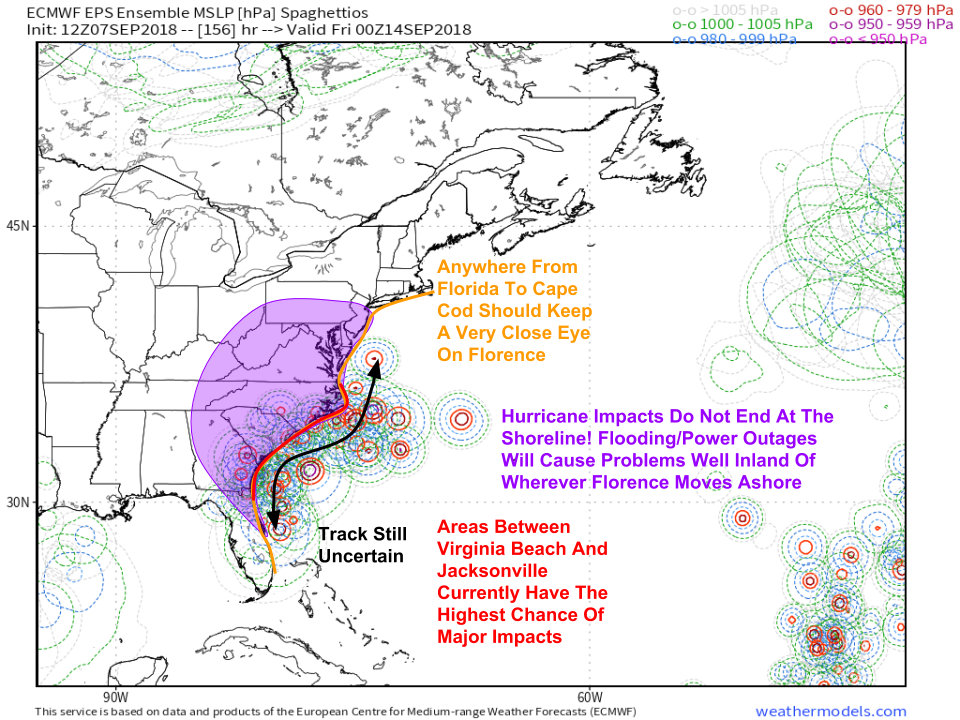
Here’s a look at the uncertainty regarding potential landfall locations. Note that some ensemble members do not depict landfall, but rather a close pass of the Outer Banks with the storm’s center remaining offshore. Folks from Cape Cod all the way down to Florida should keep a very close eye on the forecast for this storm. Based on currently available information, the areas with the best chance of seeing major impacts are North Carolina, South Carolina, and Georgia.
Map via weathermodels.com.
If you live in those areas, this weekend is the time to carefully review your hurricane plan to make sure you know what you’d do if forecasts early next week called for significant impacts in your area. This weekend is also a great time to stock up on the basic essentials everyone else will be scrambling for if forecast confidence ends up increasing in the major impact scenario. Bottled water, non-perishable foods, batteries, and the like are all going to be in short supply if current forecast trends hold, so you’ll be at an advantage if you beat the rush. Even if Florence misses, those items don’t go bad, so you’ll be that much more prepared for the next storm, whatever it may be.
This weekend is also a great time to take a look around your yard. If there are any dead tree limbs/branches, especially overhanging something valuable (like your house), look into safely removing them before Mother Nature does it on her terms. Again, even if Florence misses, taking these types of preparedness actions will help you be ready for the next storm, whether that’s a hurricane, a nor’easter, or a severe thunderstorm.
For more information on preparing for a hurricane, please consult the National Hurricane Center’s Preparedness page.
I’ll have more updates here on the blog and on twitter through the weekend as the forecast becomes a bit clearer.
-Jack
