First Significant Winter Storm Of The Season Kicks Off In The East Today
Hello everyone!
It’s that time of year again, like it or not. Low pressure is developing in the Gulf of Mexico this afternoon, and it will begin its move north up the coast tonight. On its way towards the Canadian Maritimes, the storm will run into cold air from Canada, with a conglomeration of precipitation types expected to ensue as a result. This process is already underway in parts of the Lower Mississippi Valley, where snow is falling as far south as Greenville Mississippi. The storm will be roughly divided into three segments: snow/mixed precip in the Ohio Valley with the primary low, mixed precip in the Mid Atlantic with the secondary low, and snow/mixed precip in the Northeast also due to the secondary low. I’ll break down each component in this post, so read on to find out what should be expected from this system in different areas, as well as to learn a little more about how winter storms like this work!
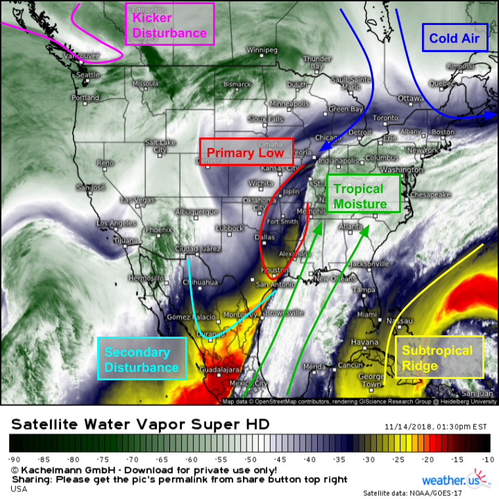
GOES-East WV satellite imagery provides a good overview of the setup for this storm as it begins to take shape this afternoon. Tropical moisture is streaming north ahead of an area of low pressure over Arkansas. A secondary upper level disturbance is set to interact with the plume of moisture over the Gulf of Mexico this evening, which will result in the development of secondary low pressure. This secondary low will be steered up the coast by a strong ridge of subtropical high pressure located near the Bahamas. Meanwhile to the north, cold air is spilling south from Canada into the Northeast. The clash between that cold air and the incoming moisture is what will set up our storm at the most basic level. The final piece of the puzzle is a powerful “kicker” disturbance moving onshore in British Columbia. This disturbance will cruise ESE tonight and tomorrow, eventually kicking our storm swiftly out to sea on Friday.
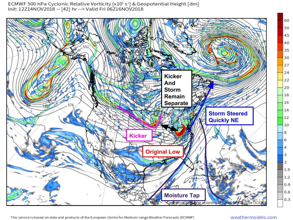
Here’s a look at the upper level setup for Thursday night, when we’ll be in “stage 3” of the storm over the Northeast. Note that the kicker and the original storm remains separate. There are a few more nuanced reasons that this is unlikely to be a big storm, but that does a pretty good job explaining the most basic reason why we’re not looking at a particularly intense outcome here. That doesn’t mean there won’t be fairly substantial impacts though, the clash of cold air and tropical moisture will still produce plenty of wintry precipitation! Map via weathermodels.com.
Now that we have a general idea of what’s going on in terms of our large scale players, it’s time to look at forecast impacts in a little more detail. I’ll run through each phase of the storm in chronological order, beginning with what’s in progress now across the Lower MS Valley.
HD radar imagery this afternoon shows bands of snow (and yes, that is snow!) rotating around the core of the upper level low across Arkansas. While it’s highly unusual to see snow this far south this early in the season, the upper level low has enough cold air to get the job done. These bands of snow may produce some coatings on cooler surfaces, and could result in some isolated slick spots on the roads, but otherwise nothing too impactful is expected until you move farther northeast into parts of MO, IL, and KY.
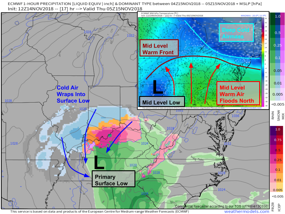
Here’s a look at the forecast setup for tonight. The mid/upper level low will be drifting from central AR to near Memphis, while the surface low will be drifting through the Nashville area. Out ahead of the mid/upper level low, warm air will be streaming north, as the 850mb (~5,000 feet) temperature map shows. However at the surface, winds will still be out of the north/northeast until you get SE of the surface low. As a result, there will be an area covering much of northern Kentucky and southern Indiana/Ohio where above freezing temps will be present aloft, but the near-surface air will be below freezing. This will result in mixed precipitation such as freezing rain and sleet, which will make for very slippery roads. Farther northwest where the cold airmass is deeper, snow will fall across parts of SE MO and S IL. A few inches of accumulation are possible, so if you happen to be out on the roads late tonight in these areas use caution. Map via weathermodels.com.
By tomorrow morning phase one will still be ongoing in parts of the Northern Ohio Valley, with snow and mixed precip continuing to move northeast as shown on the forecast map below. Several inches of accumulation are possible in parts of central IL, with lighter amounts to the east.
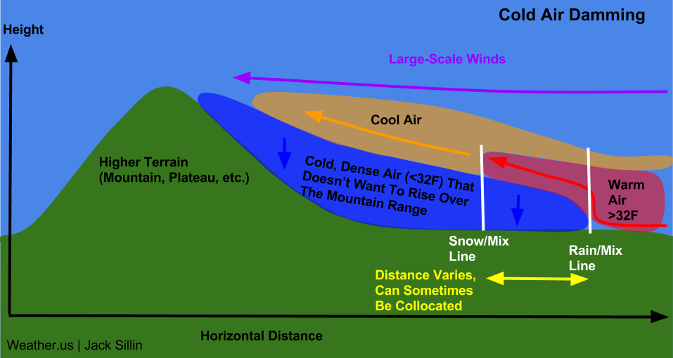
While the primary low won’t be fully dissipated yet, this will be the time we turn our attention to phase two in interior parts of the Mid Atlantic. The draw of warm air northward by the primary low will continue to occur, but cold air will get hung up in the higher terrain of West Virginia as well as western parts of VA and NC. This cold air damming will result in a pocket of near-surface cold air that’s below freezing, which is exactly what you need to get sleet and freezing rain. The farther south you go in this area, the shallower that cold pocket will be, and thus the higher the odds are that mixed precip falls as freezing rain instead of sleet. Farther northeast in places like DC and Baltimore, the presence of deeper cold air will allow for a brief period of snow before a changeover to mixed precip. Map via weathermodels.com.
How does Cold Air Damming work? This schematic provides a general overview of how mountainous terrain oriented perpendicular to the wind flow can result in trapped near-surface cold air.
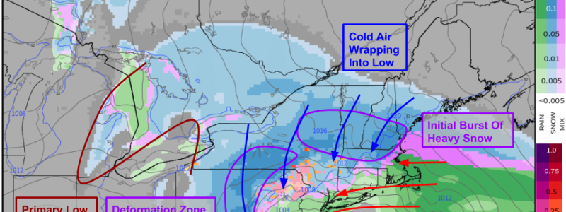
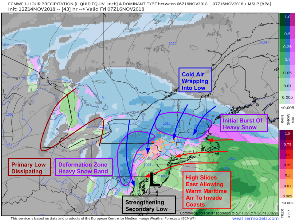
By tomorrow night/Friday morning, phase three of the storm will be underway in the Northeast with two areas to watch for bands of heavy snow. The first area will be on the front side of the secondary low strengthening over the Delmarva. That front end burst should put down a brief coating-2″ in places like NYC, Hartford, and Boston before warm air invades both aloft and near the surface. The second area to watch for the heavy bands will be on the back side of the low, from central NY through central PA in what’s known as the “deformation zone.” Note that by this time, the primary low will be reduced to little more than some flurries near Lake Huron as the secondary low assumes full control of the situation. Map via weathermodels.com.
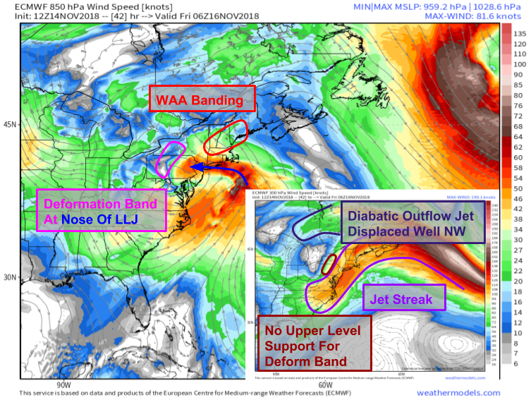
So what will the dynamics for these heavy snow bands look like? Here’s a quick glance at two levels of the atmosphere important to the production of heavy snow: 850mb (~5,000 feet) and 300mb (~30,000 feet). The 850mb level will show us what’s going on with the low level jet, while 300mb gives us clues about the upper level jet. While there is indeed a LLJ pulling moisture west into the cold airmass, there’s little if any support from the upper level jet. We typically look for jet support in the right entrance and left exit regions of jet streaks, and neither box is really all that checked on Friday morning. A feature known as the “diabatic outflow jet,” fancy parlance for “storm exhaust pipe,” is displaced well to the northwest over Central Ontario/Quebec, way too far from the storm to provide any help. As a result, while a deformation band is likely to form, don’t expect any of the extreme dynamics that produce 2-4″ per hour snowfall rates without help from the upper levels. Map via weathermodels.com.
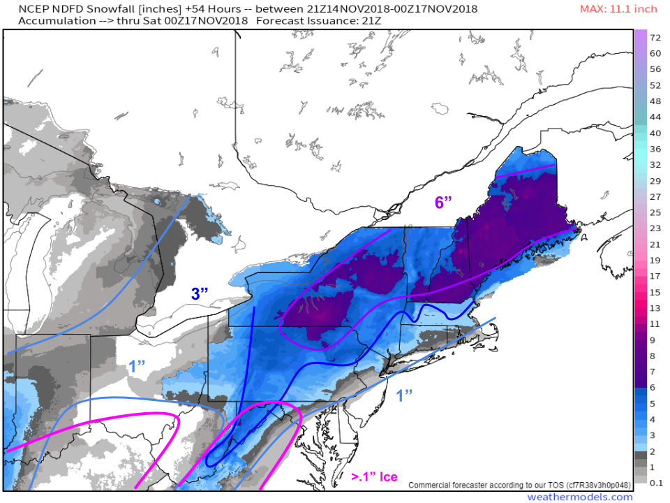
So how much snow are we expecting? Here’s a map of the forecast snowfall from each local NWS office stitched together into a regional composite. I’ve overlayed my rough outline of what I personally think will fall, along with the areas in the Ohio Valley and Mid Atlantic that need to watch out for ice. Some parts of the NC/VA/WV mountains may see enough ice to cause power outage issues (.5″) but most of the ice will just be of the hazardous-to-travel variety. Remember, it hardly takes any ice at all to separate your tires from the road surface! Map via weathermodels.com.
The storm will depart quickly on Friday as the kicker disturbance arrives in the Great Lakes.
-Jack




This is impressive!! I just got my degree in emergency management in May and do a lot of disaster response and recovery. I am near Panama City Beach county and Mexico Beach and have done a lot including just leaving there this morning. And last weekend… Anyway it was a bad hurricane category for iamb also 13 member which stands for certified emergency response team. I have searched high and low for a good app I had paid up to four dollars for a Weather app that I was not happy with and I didn’t get accurate alerts or timely alerts for severe weather. I’ve tried Noah I tried the weather channel they do not allow me to even get alerts even though I’ve been to their website and signed up… Do you know of one do y’all have an app? For iOS anyway I really enjoyed your blog it’s very thorough and detailed and I’m going to share it and send it with other people !