Fast-Moving Winter Storm To Bring Snow, Ice, and Storms To The Eastern US Monday-Tuesday
Hello everyone!
With the storm that brought warm air and heavy rain to much of the East Coast now departing into Canada, attention will turn to the next system which is now emerging east of the Rockies in Colorado. While light/moderate snow is expected across parts of the Plains tomorrow, this system won’t get its act together until it reaches the Mississippi River on Monday. By then, the storm will have better access to moisture from the Gulf of Mexico, which will help fuel severe thunderstorms in the lower Mississippi Valley as well as bands of snow and ice farther north in the Ohio Valley. This post will outline what to expect from this system broadly, and will touch on both the warm-side (severe thunderstorms) and cold-side (snow/ice) aspects of the system’s impactful weather. As always, information more specific to your specific town can be found at weather.us by typing your town’s name into the search box.
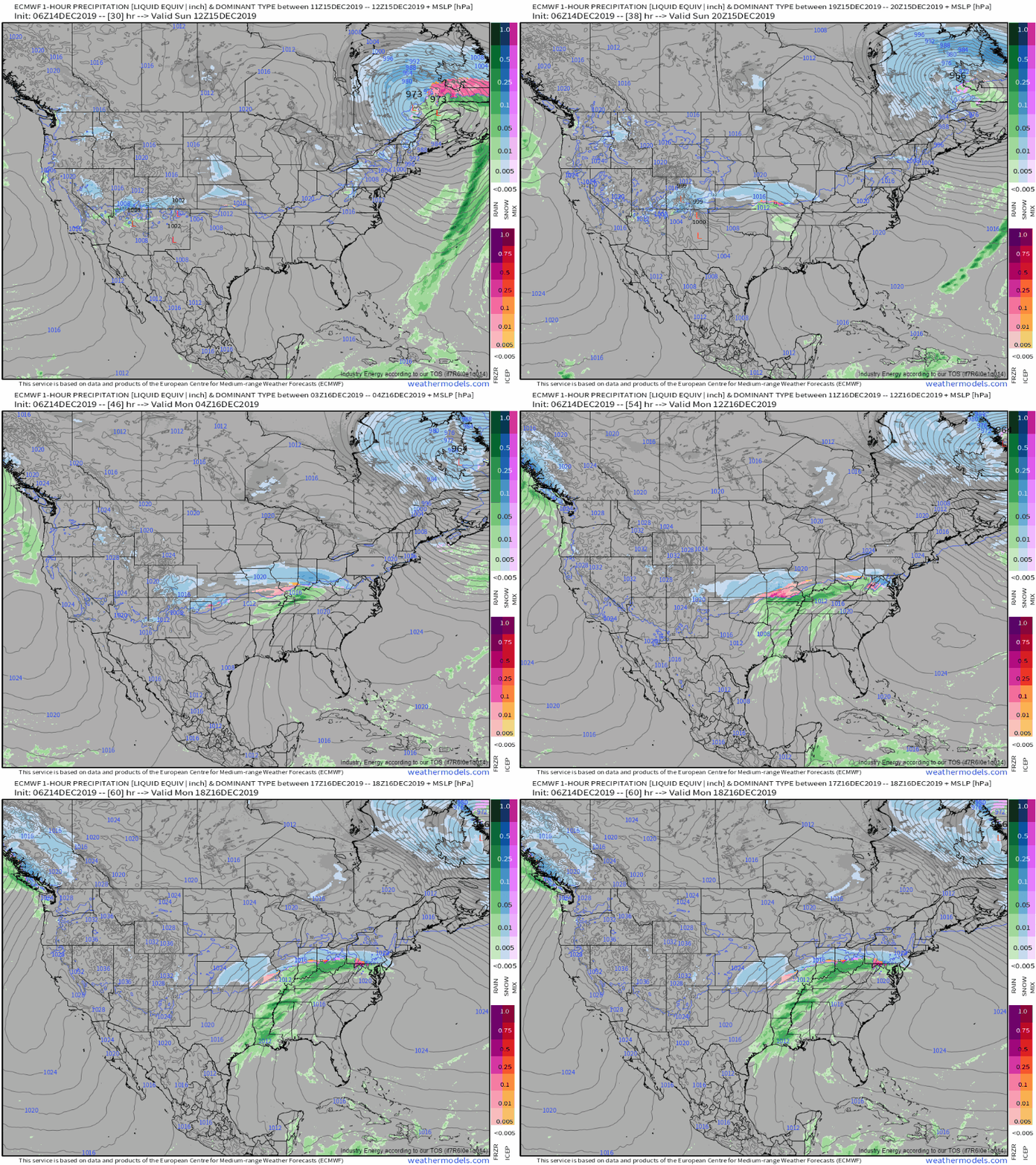
Here’s a look at hourly ECMWF forecasts of MSLP (contours) and precip type (shading) between the system’s emergence onto the Plains tomorrow and its development as a more consolidated system over the southern Mississippi Valley on Monday afternoon. While the snow and ice associated with the storm will certainly be impactful, perhaps the more noteworthy threat from the storm will come in the form of severe thunderstorm activity in parts of the Deep South on Monday. With that in mind, let’s take a look at the ingredients needed for severe thunderstorm development and to what extent they’ll be present over the Southeast on Monday. GIF via weathermodels.com.
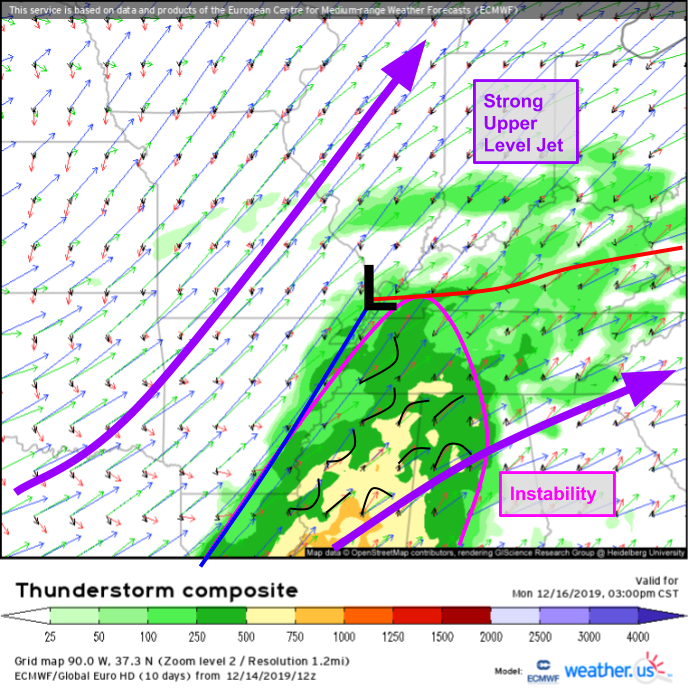
The first place to start when looking at a potential severe thunderstorm event is our Thunderstorm Composite product which lets you visualize where instability (shading = CAPE), wind shear (vectors = wind vectors color coded by pressure level), and frontal boundaries (inferred from 10m wind vectors colored in black) are located. A quick analysis of the ECMWF’s Thunderstorm Composite forecast for Monday afternoon shows an environment favorable for severe thunderstorm development across parts of Louisiana, Mississippi, Tennessee, and Alabama. Warm moist air moving north ahead of the front combined with falling temps in the mid levels will create a layer of unstable air, while strong jet stream winds will provide ample wind shear to get thunderstorm updrafts rotating. A cold front will provide the lifting mechanism to initiate storms, so some sort of severe weather appears likely.
While the presence of the necessary ingredients tells us that severe storms are likely, determining what severe threat is most likely requires a bit more analysis. Based on veering wind profiles farther ahead of the front (where the little black lines I’ve drawn appear to be “pointing” NW), supercells are possible but backing winds closer to the front (where the little black lines bow towards the SE) as well as the stronger linear forcing the front provides both point to more consolidated line segments eventually becoming the dominant storm mode.
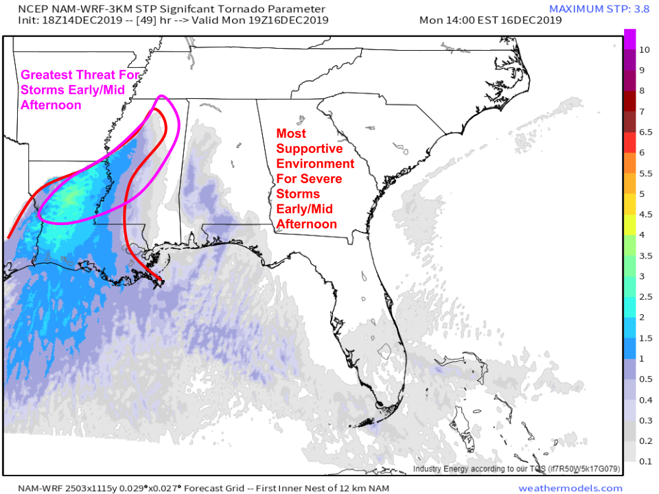
During the early/mid afternoon hours, the severe weather threat will be focused over central/northeastern parts of Louisiana and western Mississippi as the cold front moves slowly through these regions. Damaging winds look to be the primary threat, though tornadoes and hail are possible with any storms that manage to pop up a bit ahead of the front. Map via weathermodels.com.
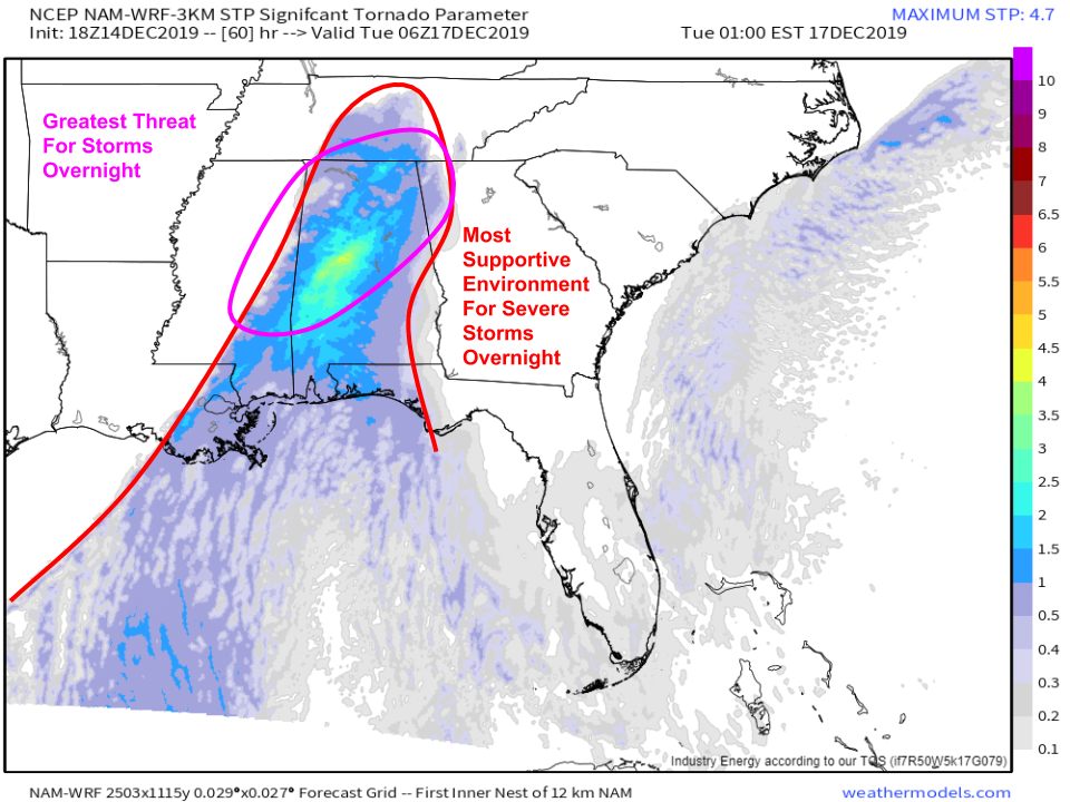
The severe threat will shift to the east later tomorrow evening as the system moves east. Strong moisture advection from the Gulf of Mexico will keep the atmosphere supportive for severe storms even after dark, and wind profiles will be perhaps even more conducive for rotating storms over Alabama than they were over Mississippi. While this does not appear to be a major tornado outbreak, the risk for strong nocturnal tornadoes over Central Alabama is certainly non-negligible. Make sure you take a few minutes tomorrow to make sure your weather radio is in good working order and that you have multiple ways of receiving warnings even if you’re asleep. Map via weathermodels.com.
Some thunderstorms are likely on Tuesday in the Carolinas, but they appear to pose a lower-end damaging wind threat and thus won’t be discussed in depth here.
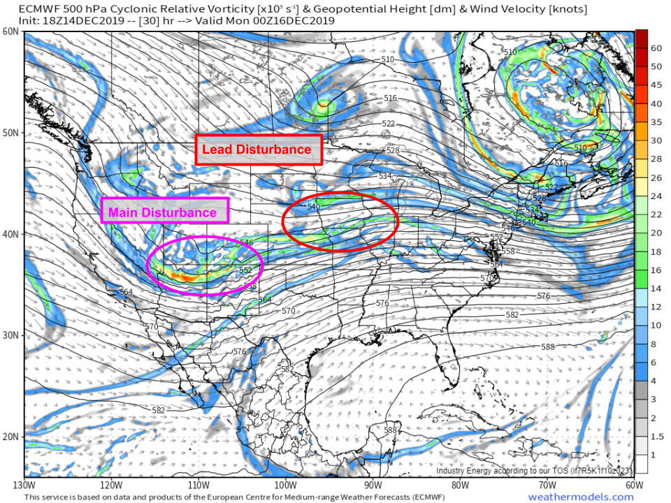
The cold side of the storm will be a bit more disorganized than the warm side as two upper level disturbances are kept just far enough apart to prevent serious consolidation into a larger storm.
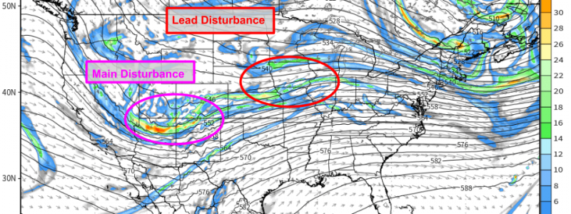
The lead disturbance will be about 12 hours ahead of the main storm system, and will bring a round of moderate snow to parts of the Plains and Central Mississippi Valley tomorrow before heading towards the Mid Atlantic Monday. Perhaps 1-3″ can be expected with this round of snow before the second disturbance arrives in the Plains tomorrow night before moving into the Central Mississippi Valley Monday. The strung-out nature of this system is readily apparent on the 500mb map shown above, and as a result, this appears to be a relatively low-end winter storm that will lack in the robust dynamics needed to produce extremely heavy snowfall rates or high snow totals. Map via weathermodels.com.
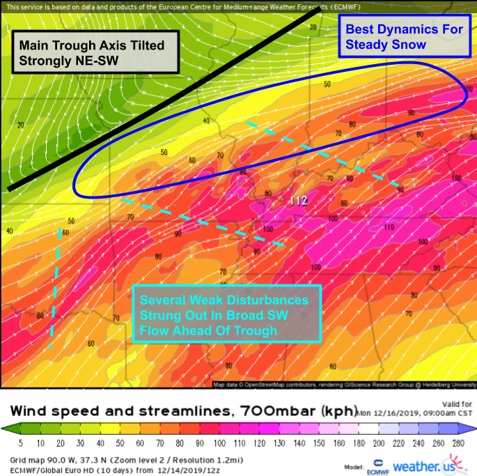
The system’s strung-out NE/SW orientation is also easy to spot on 700mb forecast maps like the one shown above valid on Monday morning. Several disturbances (wind shifts) are visible ahead of the main trough axis (mid-level frontal boundary), but they’re each spaced just far apart that they can’t consolidate into one strong system capable of producing heavy snow. The best chance for steady moderate snow will be found along the northern edge of the mid-level SW flow, where a process known as frontogenesis will be taking place.
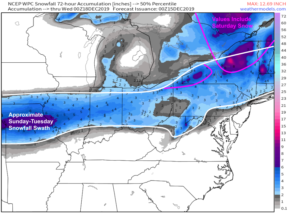
Snowfall accumulation forecast guidance points to the same swath of the Northern Ohio Valley identified by the 700mb wind forecast as being most favorable for accumulating snow. Helpfully, the snowfall accumulation values are consistent with our expectation of a relatively low-end event. I suspect we’ll see lots of 3-5″ totals out of this storm, though as with any storm there will be localized winners and losers depending on terrain influences and were the best bands set up/linger. As the storm encounters the Appalachians, it will try to consolidate a bit more which will likely lead to a modest northward expansion of the snow shield into NY/New England. That being said, the mid/upper level flow pattern (winds generally blowing from west to east without any major ridges/troughs) points fairly strongly towards this being a fast-moving and relatively weak storm. Map via weathermodels.com.
The other wintry aspect of this storm to keep an eye on will be the ice. This system is likely to produce a swath of ice because it features a strongly sloped warm frontal boundary where the warm front a few thousand feet above the ground is located much farther north than the warm front at the surface. Warm air rising up along that sloped frontal boundary is actually the mechanism that will be responsible for much of the precipitation, including the snow. However, this configuration means that warm air will move in faster aloft than it will at the surface, meaning that we’ll have to worry about ice. Ice forecasts from the ECMWF model are horribly overdone numerically, especially in PA/NJ, but the spatial distribution of accumulating ice looks pretty good. This doesn’t look like an ice storm capable of producing substantial power outages, but of course it only takes a very thin glaze (a couple hundredths of an inch) to make roads and sidewalks nearly frictionless. Take it slow if you need to travel through PA or nearby parts of the Ohio Valley on Monday! Map via weathermodels.com.
The storm will bring a similar swath of light/moderate snow and ice to New England on Tuesday before racing into the Atlantic on Wednesday.
-Jack
