Fast Moving Storm To Bring Rain And Snow To Parts Of The East For Superbowl Sunday
Hello everyone!
While we remain in a pattern generally unfavorable for major storms, minor but reasonably impactful systems continue to move from the Central US through to the Northeast every few days. Our last system brought rain transitioning to snow yesterday morning in parts of New England, and the next system is set to bring another rain of light to moderate rain and snow tomorrow.
Analysis
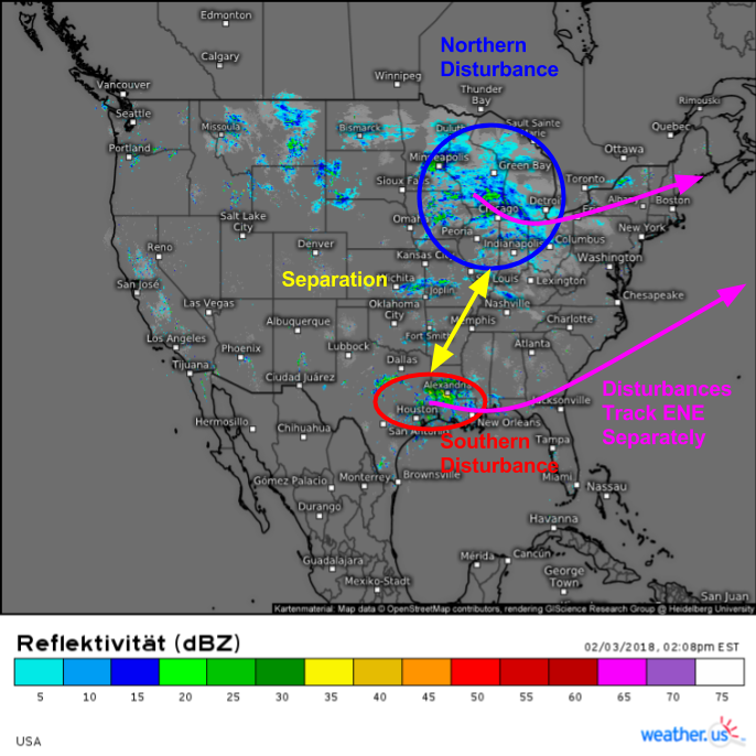
Current radar composite imagery shows two disturbances causing precipitation in the middle of the country this afternoon. Click any of our composite radar products to zoom to state level for HD imagery, and click again to get county level HD data for an even closer look. The southern of the two systems is currently bringing showers to parts of SE Texas and Louisiana, while the northern system is bringing light snow to the Great Lakes. Notice on the map above that there’s a good amount of separation between the northern and southern systems, a trend which will continue as both move east then east-northeast over the next 24 hours. Not only are the systems at different latitudes, the southern component is also considerably farther to the west than the northern component. This means that the northern component, and the southerly winds to its east, will arrive in the Northeast before the southern component and the northerly winds to its west. I’ll talk more about the ramifications of this disconnect in a minute.
The ECMWF’s 500mb forecast map for Sunday night shows all the reasons why this won’t be a major storm system. When we have northern and southern stream disturbances converging on the East Coast’s natural baroclinic zone (the powder keg of potential energy that results from the gradient between the warm Gulf Stream and the cold polar airmasses over the North American continent), we expect a storm of some sort to develop. The question is always about track and intensity, the two most important factors in determining impacts along the East Coast. This setup will be no different, and a storm will form off the Mid Atlantic coast late in the day on Sunday as the southern disturbance meets up with the baroclinic zone. However, just about every other feature on the map will conspire to keep this storm from being too impactful. The Polar disturbance that would typically guide a developing storm NNE up the coast is positively tilted from NE to SW, meaning that WSW winds ahead of it will push the storm ENE out to sea. The Arctic disturbance that would typically take the positively tilted Polar disturbance and turn it neutrally (N-S) or negatively tilted (NW-SE) is strung out and weak, therefore becoming a non-issue. Finally, the flow upstream of our various disturbances has a strong zonal (W-E) component to it, and the upstream ridge over the West Coast is extremely low in amplitude. Downstream of a low amplitude ridge, you’d expect to find a low amplitude trough, and that’s exactly what’s forecast.
Map from weathermodels.com.
However, this won’t be a complete non-event. There are a few factors working in favor of moderate precipitation Sunday night into Monday morning.
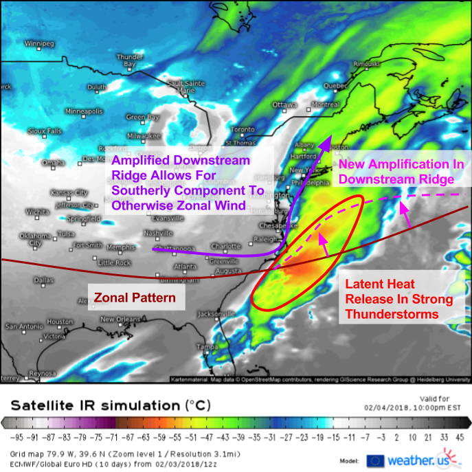
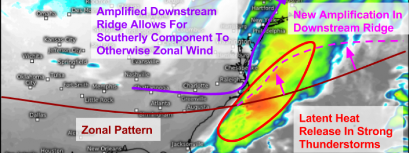
ECMWF simulated satellite imagery shows an area of strong thunderstorms developing in association with the southern disturbance discussed above tomorrow night. These storms will release tremendous amounts of heat into the upper atmosphere, which will amplify the previously flattened ridge downstream of the system. This amplification won’t be enough to turn this into a major storm, but it will be enough to add a little bit more of a southerly component to the otherwise zonal (W-E) wind. As a result, we’ll be able to get a little bit of moisture transport from the southern system back towards the northern system. This link will help to drive moderate, and potentially even heavy, precipitation tomorrow night into Monday morning.
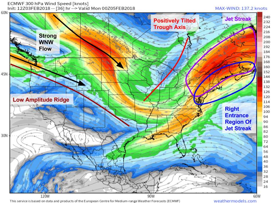
ECMWF 300mb forecasts show a few of the same features as 500mb, as well as one new feature that will play a key role in the forecast. That feature is a jet streak extending from Upstate NY through SE Quebec and into the rest of Atlantic Canada. The right entrance region of this jet streak will be located over the eastern 2/3 of the Northeast tomorrow evening, as well as occupying some territory offshore. Diverging air aloft in the entrance region of this jet is favorable for enhanced upward motion. As airstreams diverge in the upper levels, more air is being removed from this area than is being transported into it. The result is an area of low pressure that air from below rushes up to fill. This upward motion will contribute to an environment favorable for moderate-heavy precipitation. Despite these favorable dynamics, the same root problems as 500mb remain with the 300mb setup. Strong WNW winds are noted over the Western part of the continent with a very low amplitude ridge near the West Coast. Furthermore, the trough axis over the Great Lakes remains positively tilted, a sign that this system will be a fast mover.
Map from weathermodels.com.
Impacts
Now that we know more about the overall setup of this system, and some of the forces driving the storm to behave in certain ways, we can dig into its expected impacts.
Deep South Showers And Storms
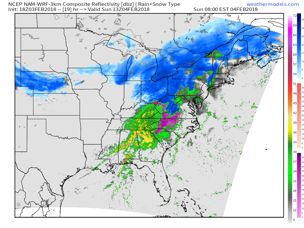
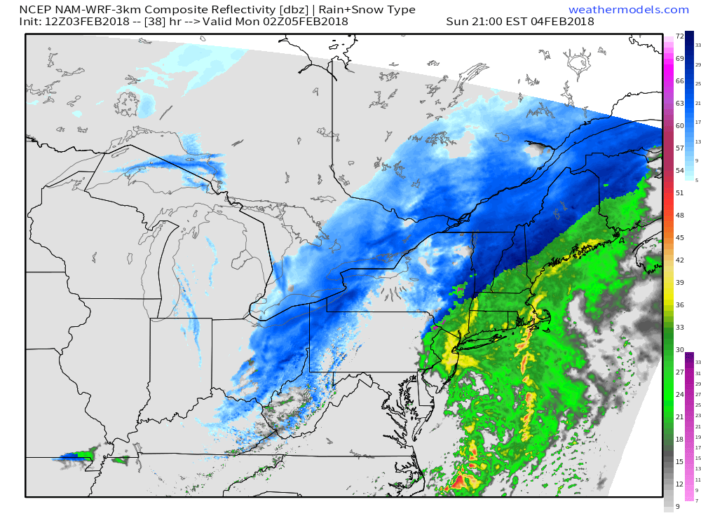
This simulated radar image valid tomorrow morning gives a good overview of what to expect across the East as the northern and southern disturbances begin to interact. The storm can be thought of as more or less four pieces, three of which are on display on the map above. The first piece will be found at the southern end of the system, and will bring showers and thunderstorms to the Deep South. Instability is expected to be too weak for severe thunderstorm activity, but lightning and heavy rain are threats with even non-severe storms. The second piece will be found to the east of the Southern Appalachians, from far NW SC through Central NC and into parts of SW VA, where ice is expected to cause potentially significant travel issues. Due to the higher impact potential of this part of the system, lets dig a little deeper.
Map from weathermodels.com.
VA-NC Ice
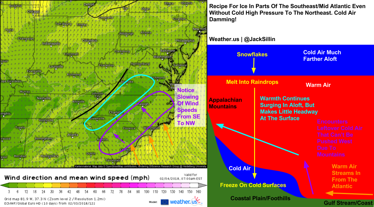
Here’s a look at winds across this area tomorrow morning. Notice SE winds get progressively weaker as you move from the coast towards the Appalachian Mountains. This is due to those SE winds being forced to rise off the ground as they encounter residual cold air that refuses to rise over the mountains due to its high density. The result is a pool of low level cold air nestled up against the SE slopes of the Appalachians. That low level cold air, with the warmth surging in above it, will create ideal conditions for freezing rain as snowflakes falling from high in the clouds melt in a mid-level warm layer, then refreeze on cold surfaces near and at the ground. Not much in the way of ice accretion is expected, but it only takes a trace of ice to cause roads to become extremely slippery, so use caution and allow for extra time if travelling in this area tomorrow morning!
This GIF from weathermodels.com shows freezing rain changing over to rain during the day tomorrow in the area we’ve been discussing. With Cold Air Damming known to be a notoriously stubborn process, why is warming expected to happen so efficiently? The answer lies not with the cold airmass becoming dislodged from its position SE of the mountains, but instead with what happens when trillions of raindrops all freeze as they hit the ground. When a raindrop freezes, the water that comprises it undergoes a transformation known as a change of state, from its liquid state (raindrop) to its solid state (ice on your house/car/tree/road etc.). Any material in its solid state has much less energy than that same material in its liquid state. As a result, a transition from liquid to solid results in a net loss of energy for that material. One of the fundamental laws of the universe is that energy cannot be created or destroyed, it is conserved. So where does that energy from the now-ice drop go? Out into the atmosphere in the form of heat (more specifically, latent heat). Each raindrop won’t release enough latent heat to do anything to the temperature, but in a moderate-heavy band of precipitation, this latent heat release process occurs enough times (trillions) to warm temperatures just above freezing, and turn freezing rain into plain rain, even if no warm air has arrived from the southeast.
Interior Northeast Snow
The northern part of the system will be divided into two impact areas: the rain/wind, and the snow. I’ll start with the snow as it will bring more impacts, albeit to a much smaller population. As the northern disturbance moves through the Northeast, it will bring colder air into the mountains, and warmer air into the coast. In the mountains, the moisture transport I discussed in the analysis section will produce bands of moderate to heavy snow as that moisture is forced to rise through a cold airmass. Snow is already ongoing in association with that northern system across the Great Lakes, and those light/moderate bands will pick up a bit tomorrow once we introduce some of that moisture from the southern system.
Map from weathermodels.com.
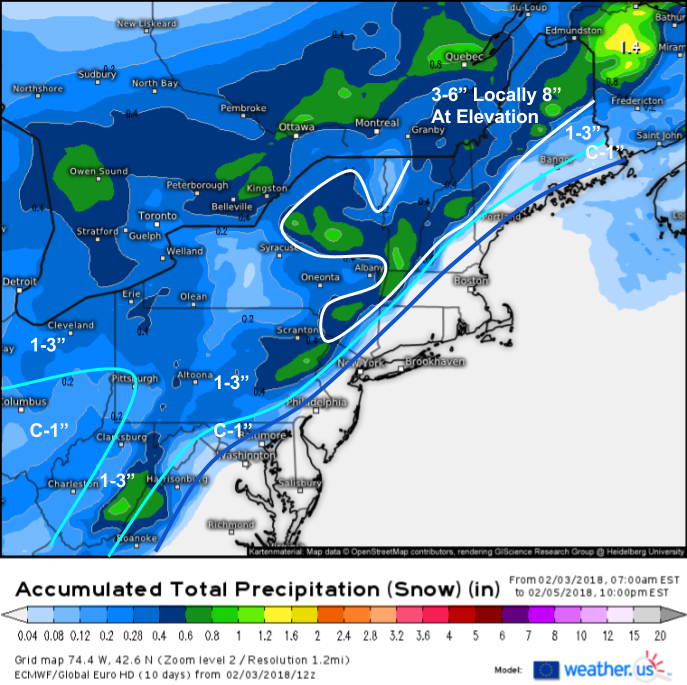
Here’s a look at how much snow to expect from this system, using the ECMWF’s liquid equivalent snow map (what’s that?) as a base. The highest totals will be found in the mountains of Upstate New York and New England where up to 8″ of snow is possible. Totals will rapidly drop off to the southeast where precipitation will fall as rain due to warm southwesterly winds that are already in progress. Lighter snows are expected farther west in the Ohio Valley where the northern disturbance will move through tonight before it can tap into the southern disturbance’s moisture supply.
Coastal Northeast Rain/Wind
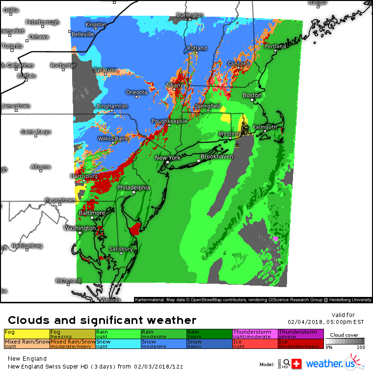
This Swiss Super HD model map shows bands of heavy rain affecting parts of the coastal Northeast and Mid Atlantic tomorrow evening as snow falls across the interior. Though major flooding issues are not expected, minor street/small stream flooding is possible due to the locally heavy rain rates. Even a few rumbles of thunder can’t be ruled out across parts of Cape Cod as some of the heavier bands roll through.
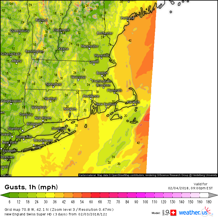
Winds will also pick up along the coast especially tomorrow night as the southern disturbance triggers cyclogenesis offshore. Gusts of 35-45 mph are expected from Long Island up through coastal parts of Southern New England and into the coast of Maine. While these winds won’t be strong enough for any widespread damage, scattered power outages are certainly possible.
The storm will race ENE into the Canadian Maritimes Monday morning bringing rain, snow, and wind to an end.
-Jack
