Fast Moving Disturbance To Bring Snow From Wyoming To New York Tomorrow Into Monday
Hello everyone!
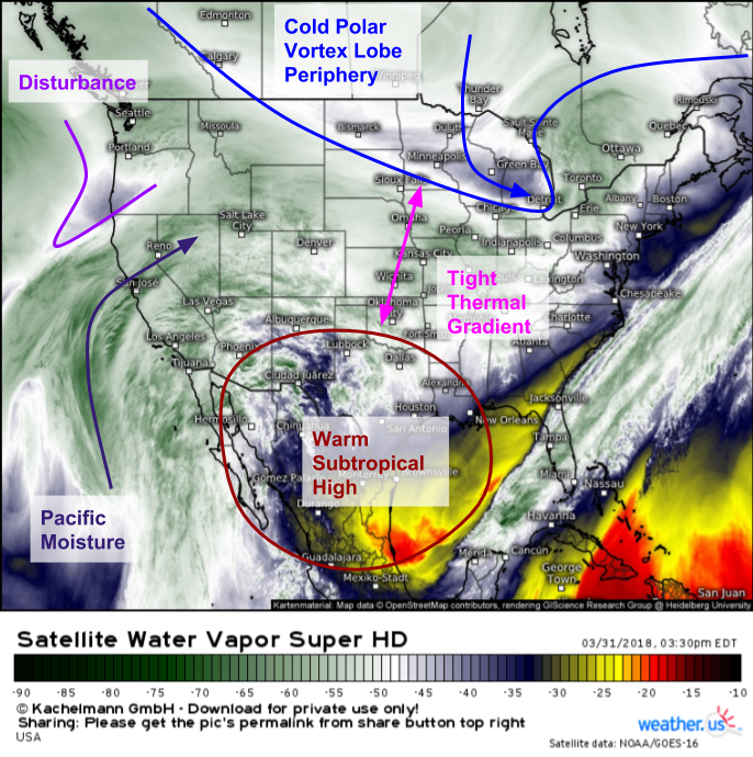
A disturbance making its way onshore in Oregon this afternoon will drive quickly east tonight, emerging onto the Plains by tomorrow morning. As this disturbance traverses the tight thermal gradient that exists between a subtropical high pressure system over Northern Mexico and a lobe of the Polar Vortex near Hudson Bay. This system will be a fast mover, but it will tap enough moisture from the Pacific, and will be interacting with a strong enough thermal gradient, that snow is expected to fall from Wyoming all the way to New York City by Monday morning.
GOES-East water vapor satellite imagery (what’s that?) shows the setup well. We can see our area of subtropical high pressure, the cold air and energy associated with the Polar Vortex lobe, the thermal gradient between the two, and the disturbance itself along with its meager but existent tap of Pacific moisture. Satellite loops also clearly show how this storm’s track envelope is fairly small. A strong zonal (W-E) component to the flow, as well as the “bumpers” imposed by the subtropical high and the Polar Vortex lobe, will ensure this system tracks ESE from WY down towards the OH valley, before turning E then slightly ENE as it exits the Mid Atlantic coast. This storm isn’t turning into a major Nor’easter, nor is it likely to fizzle out into nothing.
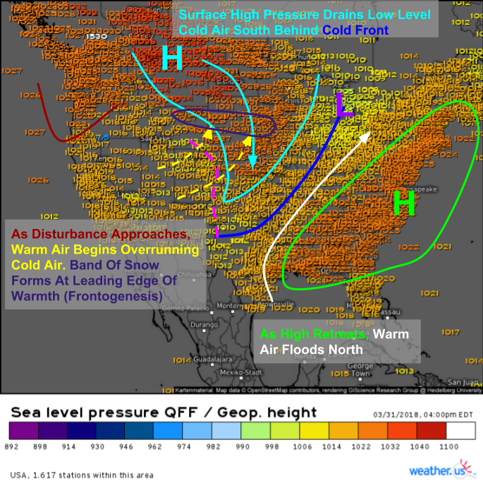
Current sea level pressure observations give us a good starting point to examine the dynamics associated with this system, because the overall setup won’t change much between Wyoming and New York. The general idea is that low level cold air is moving into place behind a cold front moving through the Mississippi Valley currently. As the OR disturbance moves east, it will spark the development of southwesterly winds just above the surface. These southwesterlies will push warm air containing Pacific moisture up and over the low level cold. This process will result in lift, which will result in the development of snowfall. The heaviest bands of snow will occur right at the nose of the southwesterlies where frontogenesis (the creation of a front via the strengthening of a horizontal temperature gradient) will be occurring.
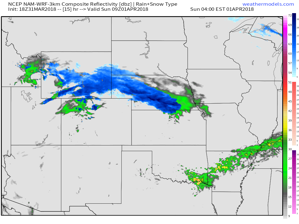
The NAM model shows some of those heavy snow bands developing early tomorrow morning across parts of Nebraska, which will be right on the nose of those southwesterlies. In the heavier bands, expect 1-3″ per hour snowfall rates, especially before sunrise. Once the sun rises, energy from solar radiation will likely limit additional accumulations, though those areas under the heaviest snow will continue to see accumulations especially on grassy surfaces even during daylight hours. Map via weathermodels.com.
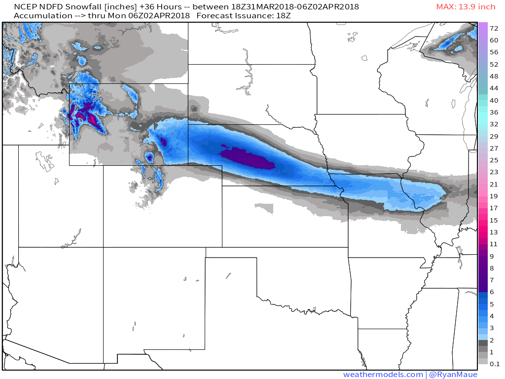
Snow will continue to spread ESE tomorrow during the day, but accumulation potential will wane as we begin to contend with the effects of the strong early April sun. Notice the dropoff in forecast accumulations from Central Nebraska (nighttime snow) to Northern Missouri/Central Illinois (daytime snow). Also notice the narrow nature of the snow swath. While this is a fairly high confidence forecast, any errors of 10-15 miles in the placement of the snow bands will result in some pretty substantial changes to the forecast for areas near the periphery of the snow swath. Map via weathermodels.com. Accumulations will be most noticeable on grassy/elevated surfaces due to the marginal temps involved.
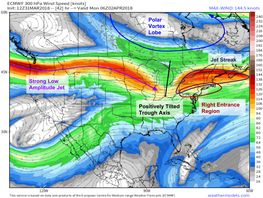
As the system approaches the East Coast, it will try to redevelop a little bit by Monday morning. This is not the type of pattern conducive to major Nor’easter type re-intensification, as indicated by the strong low amplitude jet stretching from the WA/OR border down towards Chicago, as well as the positive tilt of the trough axis (from NE to SW). This system will keep racing ENE, but the question is how heavy will the snow be while it sticks around. An anticyclonically curved jet streak is noted extending from Western PA through Northern New England, with the Northern Mid Atlantic/Southern New England area located in the right entrance region of that jet streak. It’s in that right entrance region that dynamics will be favorable for a burst of heavy snow early Monday morning. Map via weathermodels.com.
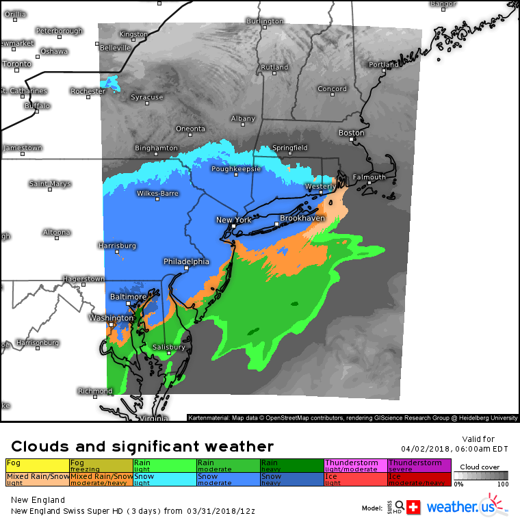
The Swiss Super HD model shows exactly what we’d expect from a jet configuration like that forecast above by the ECMWF. An area of steady snow will extend from near Baltimore/DC (how much if any snow actually falls in those cities remains uncertain) up through Philadelphia and into NYC. There could even be a few heavier bands as the same overrunning/frontogenesis dynamics we saw out on the Plains become enhanced by the jet streak. Most of the area will be cold enough for snow, with the exception of the Jersey Shore, and areas SE of Baltimore/DC.
The northern extent of snow will be limited by low level dry air, and the generally zonal nature of the pattern. This isn’t the type of setup conducive to moisture getting pulled back to the NW or into Northern New England, where most folks won’t even see a flake before the system cruises offshore Monday afternoon. As with the Plains, accumulations will remain highly dependent on time of day. Areas that see overnight snow such as PA/MD/WV are much more likely to see meaningful accumulations than those areas that see snow just beginning at sunrise (CT/RI/MA). Also similarly to the Plains, accumulation will be most pronounced on grassy/elevated surfaces with very little snow likely to stick to roadways, which will be warm from the airmass currently in place, which features temps generally in the 50’s as of this evening.
Track this storm with GOES-East satellite imagery https://weather.us/satellite/usa/satellite-water-vapor-superhd-5min.html#play, HD radar https://weather.us/radar-us, and current observations https://weather.us/observations/temperature-f.html. Click any of the maps to zoom in for a closer look, and use the menus to the left of each to navigate to other parameters/views.
-Jack
