Extremely Dangerous Severe Weather Outbreak Likely Tomorrow But Storm Mode Questions Remain
Hello everyone!
An extremely dangerous severe weather outbreak is still forecast for much of the Southern Tier of the US today through Monday as a strong storm forms in the Plains and moves northeast. I discussed the general pattern supporting these storms back on Wednesday, and the broad thoughts outlined there are still mostly relevant. Instead of focusing on the synoptic setup, this post will take a deeper dive into the smaller-scale details that will end up determining exactly how destructive these storms might be.
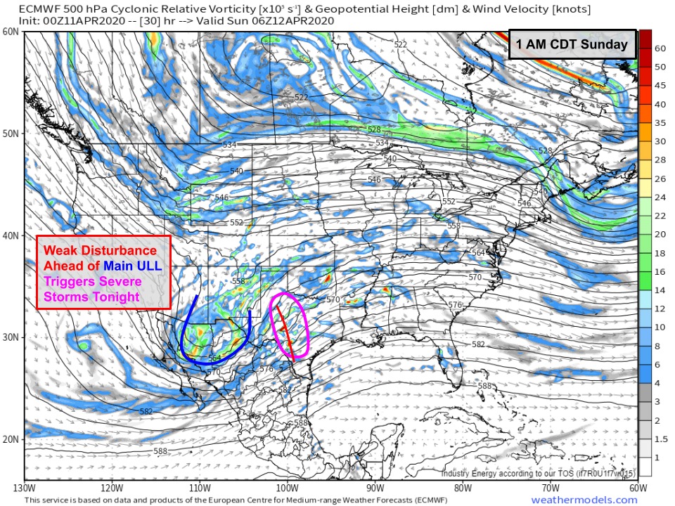
One of the keys to tomorrow’s forecast will emerge in western Texas late tonight.
The large-scale disturbance responsible for this weekend’s severe weather will be moving through far northern Mexico. Ahead of it, a very subtle but important disturbance will move northeast into Texas. Lifting associated with that disturbance as well as a dryline closer to the surface will support convective initiation late this evening. Those thunderstorms will then move off to the northeast along with that disturbance.
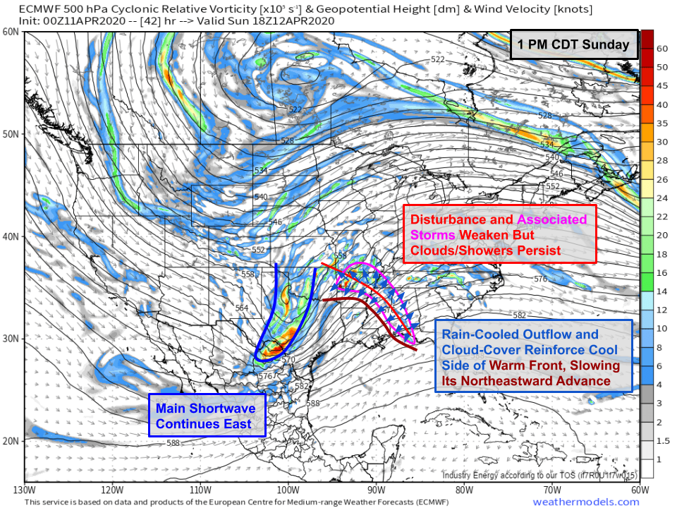
By early Sunday afternoon, the disturbance (and its associated showers/storms) will be moving through AR/MS/AL. The clouds associated with the disturbance will limit the extent to which the atmosphere can destabilize via daytime heating. Additionally, the rain-cooled outflow from these showers and storms will slow the northeastward advance of the system’s warm front by piling cold/dense air up ahead of the front. This will slow the northward advection of deep moisture from the Gulf of Mexico, a process necessary for the formation of intense supercells.
The disturbance and its showers/storms will move quickly into the Ohio Valley by Sunday evening. What happens between that lead disturbance and the main disturbance moving into AR/LA will determine whether we see long-track supercells (and associated strong tornadoes) in addition to a squall line with widespread damaging winds.
One possibility is that the lead shortwave and its associated showers/storms end up on the faster/weaker edge of the range of possible outcomes (and perhaps tracks a bit farther northwest). In this scenario, the window of time where daytime heating could destabilize the atmosphere would be longer which means more fuel would be available for supercells later in the day.
The 12z HRRR forecast looked something like this with the strongest part of the disturbance (core) moving northeast up the Mississippi Valley. The showers and storms moving through central MS/northern AL would end up weaker which would limit how much cold air they dump in front of the warm front. This would allow the warm front to move north much more quickly. Notice by 1 PM CDT, most of central MS is clear of storms and being heated by the strong April sun.
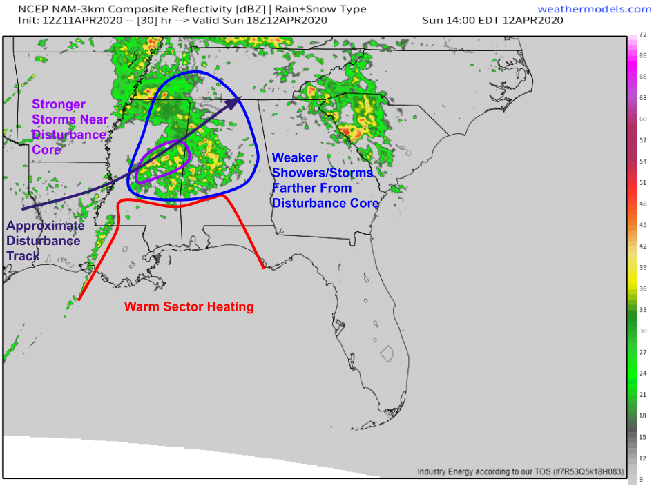
Contrast that scenario with another possibility offered up by the 3km NAM (below).
If the disturbance tracked farther south, the showers and storms moving through central MS/western AL would be stronger. That means they’d dump more cold air ahead of the warm front which in turn would slow the front’s forward motion. This forecast map is valid at the same time as the HRRR shown above but notice the persistent shower activity in Central MS while the warm sector is confined to far southern MS/AL/LA.
Which of these scenarios is more likely? It’s hard for me to see anything in observational data that points strongly in one direction or the other. It’s also hard for model guidance to lock onto one solution or the other when so much depends on how thunderstorms develop/evolve in Texas tonight. While high-resolution models like the NAM and HRRR are good at predicting how thunderstorms might generally evolve, they get easily tripped up with the details. Unfortunately, this is a situation where the details matter a lot.
Even if we assume the first scenario ends up verifying, there’s still no guarantee that we’ll see an outbreak of supercells and associated strong tornadoes. Even if ample instability develops in central MS/western AL, we still need to worry about storm mode (linear vs discrete).
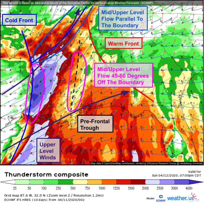
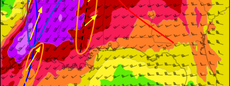
The first stop in any storm mode investigation is the ECMWF’s Thunderstorm Composite forecast map. By overlaying wind profiles (from the surface to the jet stream) with CAPE, we can identify areas where different storm modes might be favored. The first step to this analysis is overlaying surface boundaries on the map. This is mostly done using surface wind vectors with a little help from dew point and CAPE forecasts. This analysis reveals a cold front extending from western Arkansas through western Louisiana while another cold front/outflow boundary extends from SW Arkansas towards the MS River near Memphis. A warm front marks the northeastern extent of southerly flow and deeper instability while a weak pre-frontal trough is visible in Mississippi. The next step is to focus on mid/upper level winds (green = 500mb “mid-level” winds, blue = 300mb “upper-level” winds). Note where these vectors diverge I lean towards the upper level winds.
A first guess at storm mode can be made by noting the orientation of the mid/upper level flow relative to the various boundaries. Where the mid/upper level winds are parallel to the boundary, a linear storm mode is more likely while a perpendicular orientation implies some chance for discrete convection (supercells). Using this method, it’s clear that linear storm modes will be preferred over much of Arkansas while wind profiles will support discrete convection farther south in Louisiana and Mississippi.
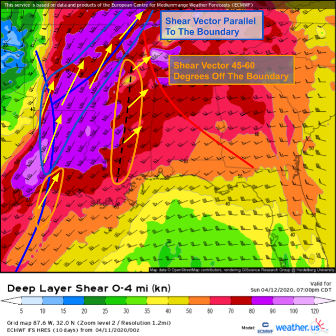
To add forecast confidence and refine our estimates, the same surface boundaries are plotted on the deep layer (0-6km) shear vector analysis. The shear vector is simply a vector drawn from the tip of the surface wind vector to the tip of the 6km wind vector, representing the change in wind speed and direction across this layer. The longer the shear vector (plotted as wind barbs on the map above), the more shear is available for storm organization. The same idea of comparing the shear vector orientation to the orientation of various boundaries applies here. If the shear vector is nearly parallel to the boundary, or if the shear vector points towards the colder side of the boundary, discrete/elevated convection is likely. If the shear vector is oriented somewhat perpendicular to the boundary (and is pointing towards the warm side), the door remains open for discrete convection.
With that in mind, we can have increased confidence that the pre-frontal trough would be a favorable place for supercells while most of the cold front in AR/LA would tend to favor linear convection (especially AR). Wind profiles in far southern LA could go either way (angle between front and shear vector ~20 degrees) but with weaker forcing for ascent in that area, I’d say discrete cells are possible.
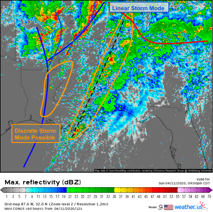
A quick glance at convective allowing model guidance (3km NAM) adds further confidence to the assessment that storms in AR/KY/TN will be linear while any storms that might pop up along the pre-frontal trough have a good chance at remaining discrete. While the model still favors discrete convection in northern LA, I’m not sure I totally buy that given the orientation of the shear vector relative to the boundary in that region.
Even after all that, it’s still not clear that we’ll see a string of supercells in MS/AL tomorrow evening. There’s one more source of uncertainty even assuming abundant instability and favorable wind profiles.
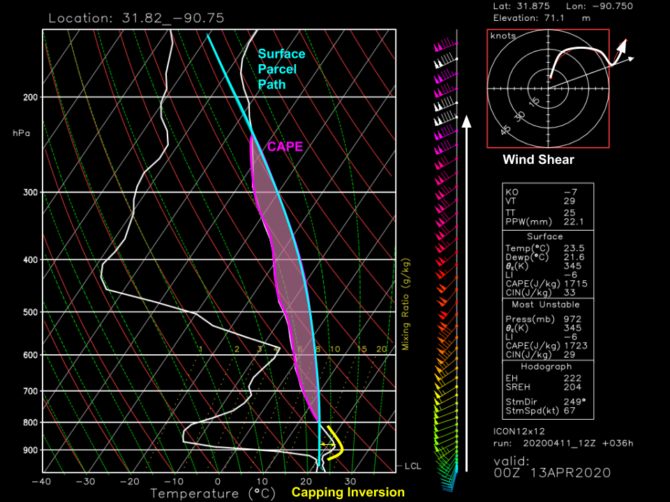
This is a forecast sounding valid at 7 PM CDT tomorrow right along the pre-frontal trough in Mississippi. We’ve already gone over the uncertainty regarding CAPE and storm mode, but we’ll look at this sounding assuming that we have enough instability to support severe convection and that storms in this area will be discrete once they form. The last (but crucially important) source of forecast uncertainty is that we don’t know if any storms will form in this region along the pre-frontal trough. Why isn’t that a foregone conclusion?
The sounding above shows a layer of warm air between ~950mb and ~810mb. In this layer, the environmental air (white line) is warmer than the rising parcel. That means the parcel is negatively buoyant and wants to sink back towards the ground. That obviously isn’t supportive of supercell formation. To break this “cap”, we’ll need a source of strong/focused upward motion.
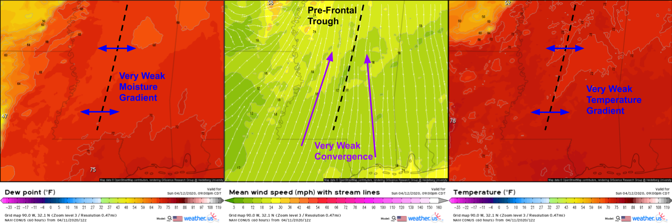
The pre-frontal trough seems like it will struggle to provide the vertical motion necessary for convective initation. There’s almost no density difference across the boundary (i.e. temps and moisture are basically the same on either side) and the near-surface convergence is meager at best. On the other hand, what little upward motion this trough can generate will be greatly assisted by synoptic-scale forcing from divergence aloft and the approaching shortwave trough.
Ultimately, the question of discrete supercell development in MS tomorrow will come down to tiny changes in the track/strength of the lead disturbance, the extent to which destabilization can occur in the warm sector during the late afternoon, and if lifting along the pre-frontal trough will be strong enough to initiate convection. If everything comes together, this has the potential to be a destructive tornado outbreak. That’s the outcome residents in this area should be planning for. Know what you’d do if a tornado warning were issued for your area and have a way of reliably receiving those warnings. That said, there are plenty of “exit ramps” the atmosphere could take to avoid the worst-case scenario.
Even if we do end up avoiding an outbreak of strong, long-track tornadoes, this will still be a dangerous event. Remember that the first off ramp involves a round of strong storms during the early/mid afternoon. Those storms might prevent the development of tornadoes in the evening, but they’d be poised to drop large hail and damaging winds as they move through. The second off ramp involves a preference for linear storm modes instead of discrete storm modes. That solution would lengthen the odds for EF4+ tornadoes, but it would expose a much wider area to damaging winds >70 mph and “weaker” but fast-moving and fast-developing tornadoes that are much harder to issue long lead time warnings for. The third off ramp is that initiation along the pre-frontal trough never ends up happening. As a result, storms developing along the cold front (even if they ended up in the form of a squall line) would have access to a deeper reservoir of fuel in the form of instability that those pre-frontal trough storms would’ve used up.
Hopefully this post has given you a greater appreciation for the uncertainty involved in tomorrow’s forecast. Plan for the worst, hope for the best, and keep an eye on it all with the tracking tools we have at weather.us. I’ll have more updates as we get closer on twitter @WeatherdotUS and @JackSillin.
-Jack
