Dorian Reaches Hurricane Status Near Puerto Rico, Will Threaten Florida By Labor Day
Hello everyone!
The tropical system we’ve been following in the Caribbean, Dorian, has reached hurricane status this evening with peak winds of 80 mph as of the 8 PM EDT NHC advisory. The system has moved much farther east than anticipated, and will not make landfall either in Puerto Rico or Hispaniola as was discussed earlier. Instead, the system will continue intensifying as it passes to the north of both islands. The shift in track means that Dorian will now face fewer obstacles on its way towards the US Mainland. Instead of having its core torn apart by tall mountains, it has a four day journey over warm water ahead. Instead of running into a wall of westerly shear over the Eastern Caribbean, Dorian will find an envelope of tremendous divergence aloft which will only serve to accelerate the storm’s intensification especially once we get closer to the weekend.
This post will outline some of the factors contributing to uncertainty in Dorian’s forecast, but the bottom line is fairly clear: if you live anywhere in Florida, now is the time to begin hurricane preparations.
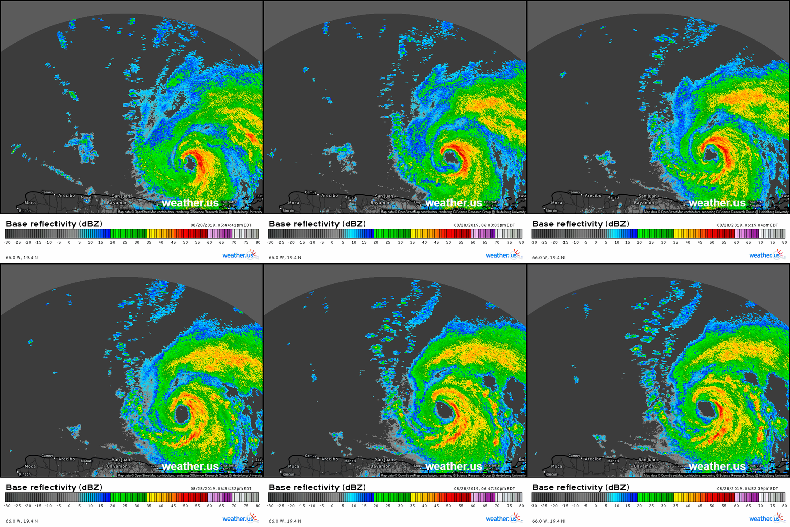
HD radar imagery from San Juan, Puerto Rico shows Dorian developing an eye as it moves northeast of the island this evening. The intensity of thunderstorm imagery near the storm’s core could use some more improvement, but the development of an inner core of any form is a notable improvement since yesterday, or even this morning. The weakest part of the eyewall remains the southwestern quadrant, but this section should fill in over the next few hours. Farther away from the center of the storm, spiral bands can be seen developing in all directions, a sign of a system relatively undisturbed by environmental factors such as dry air or wind shear.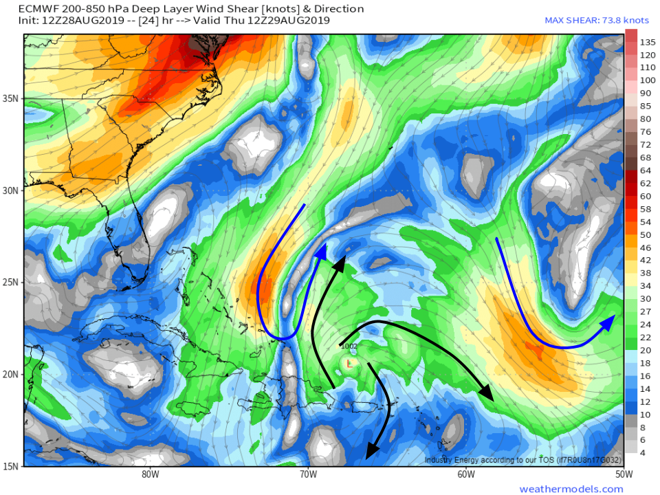
The environment will remain quite favorable for intensification as the storm continues its path northwestward tomorrow. Upper level lows near the Bahamas and out over the open Atlantic (blue arrows) will help establish upper level outflow channels in all directions. Dry air should remain only a minor concern, and water temperatures will be steadily increasing. Expect a continued increase in the system’s intensity as it remains on its northwesterly heading tomorrow through Friday morning. Map via weathermodels.com.
By Friday, all the environmental ingredients for rapid intensification look to be in place surrounding Dorian. Note that this does not mean that RI will occur. The dynamics within the storm’s inner core are crucial to determining whether or not the system can take advantage of the favorable environment, and those dynamics are still not fully understood, let along reliably predicted.
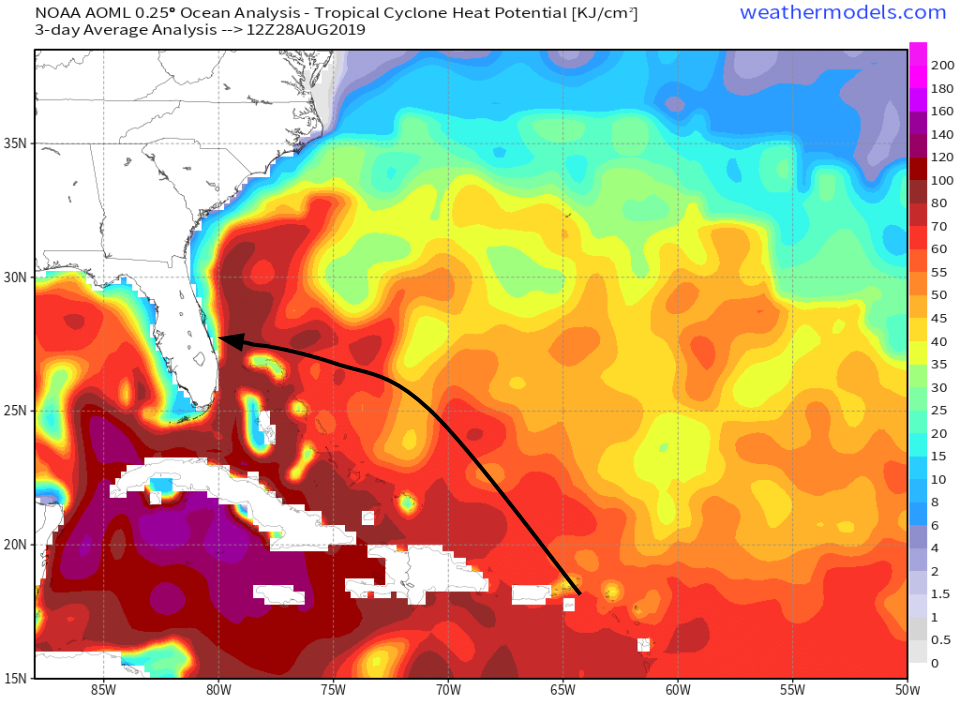
The first important ingredient for rapid intensification is very warm ocean waters. The map above shows one way to measure how much heat the ocean over a given area contains. On that map, I’ve drawn an approximate version of the NHC’s track forecast for Dorian to give a general idea of what ocean conditions the storm might encounter. Unfortunately for the Bahamas and Florida, there is more than enough heat in the ocean under Dorian’s path to support a very strong hurricane. Map via weathermodels.com.
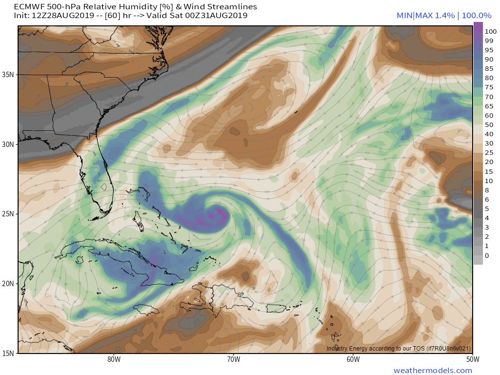
Another factor is the presence of mid level dry air that might get ingested into the system. A look at the 500mb relative humidity forecast for Friday evening shows plenty of moisture-rich air surrounding Dorian with only limited dry air to the system’s northeast and well to the south. The upper level anticyclone mentioned above will continue to follow the storm northwest, which means that the storm should be relatively unconstrained by wind shear. Map via weathermodels.com.
What is expected to happen after the storm continues intensifying on a NW heading between now and Friday?
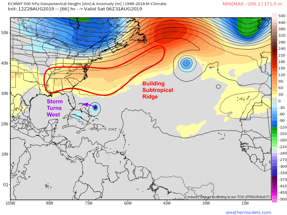
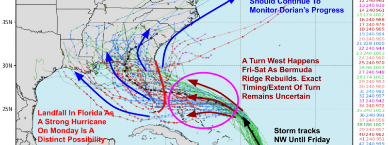
Model guidance is consistently showing a ridge of high pressure building to the north of the storm by Saturday. That ridge will be replacing a trough currently sitting off the East Coast. The result will be a shift in Dorian’s motion towards the west. The exact timing of this turn, and the extent to which the storm does turn, still remain to be seen. Map via weathermodels.com.
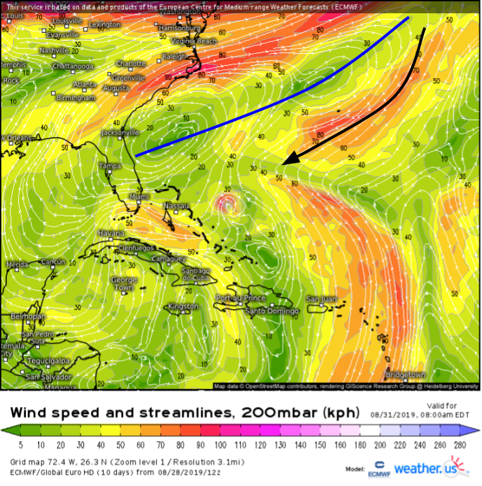
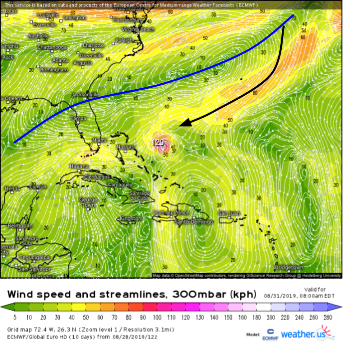
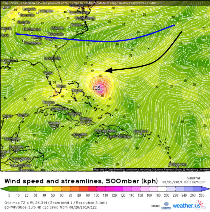
Interestingly, the system’s exact track will be determined in large part by its intensity on Saturday. How does that work? A stronger hurricane will “feel” steering currents higher up in the atmosphere compared to a weaker counterpart. The four maps below show the wind forecast for Saturday morning at four different levels of the atmosphere. Height decreases to the left. I’ve marked the approximate ridge axis in blue and the rough steering currents at each height in black.
In the upper levels (left two images), you can see the ridge is oriented SW-NE with northeasterly steering currents influencing Dorian’s movement. Lower in the atmosphere, the ridge has a more zonal (west to east) orientation with easterly flow pushing on the system. Thus a stronger storm would feel the northerly component of the upper level winds and move farther south while a weaker system would do the opposite.
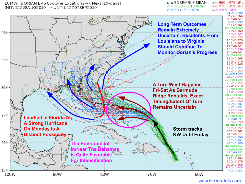
The range of possible outcomes is clearly illustrated in the afternoon EPS spaghetti plot above. Some members take a weaker storm (green lines indicate higher pressures) farther north into the Northern Florida Peninsula while other members take a stronger storm (blue/red lines indicate lower pressures) farther south towards the Miami area. Once the storm passes the Florida peninsula, another trough of low pressure will attempt to turn the system north again, but given that this turn wouldn’t occur for 7-10 days, its timing and magnitude remain a complete unknown at this point. If you live anywhere between Eastern Texas and the Mid Atlantic (this includes inland areas!) please keep a close eye on future forecast updates over the next few days. Map via weathermodels.com.
If you’re looking to see what this range of possible outcomes might mean for your weather, head on over to our Forecast Ensemble page and type your town in. There, you’ll be able to see reasonable best/worst case scenarios for rain and wind, along with a guess at what the more likely outcome might be. Need a more in-depth tutorial? This video provides just that.
Follow us on twitter @WeatherdotUS and @JackSillin for more updates in the coming days.
-Jack
