Disorganized Storm To Bring A Wide Array Of Impacts To The Central US Today
Hello everyone!
Today will feature the development of a disorganized storm system in the center of the country. As this storm slowly wobbles its way out of the Rockies and onto the Plains, we’ll need to watch for some snow in northern areas, as well as heavy rain and severe weather to the south. Given that the storm is expected to be disorganized, none of these impacts are expected to be overly intense, though they will cause some problems nonetheless.
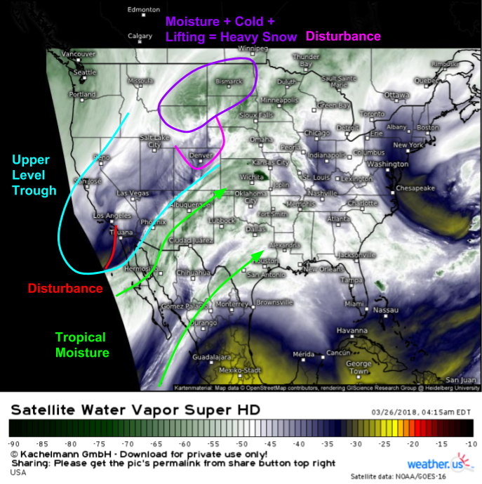
This morning’s GOES-East Water Vapor satellite imagery (what’s that?) shows ingredients moving into place for both snow in the Northern Plains and severe weather in the Southern Plains. Up north, a disturbance is moving east over N CO and S WY. It’s tapping into some tropical Pacific moisture, and plenty of cold air is nearby in Southern Canada. This combination of disturbance (lift), moisture, and cold air is already resulting in bands of moderate snow in this area. This snow will continue and move east today, dropping a stripe of 2-4″ from E MT to N MN. Some parts of E MT and N WY will see higher totals enhanced by terrain influences. Meanwhile to the south, an upper level trough is driving southwesterly flow over Texas and Oklahoma. Surface winds in eastern parts of these states are southeasterly, and are transporting low level moisture from the Gulf of Mexico northwestward. As the sun comes out today, look for destabilization to occur in advance of an upper level disturbance currently moving onshore near the CA/Mexico border.
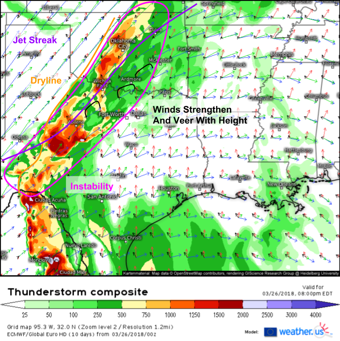
Here’s a look at the severe setup through the lens of the ECMWF’s Thunderstorm Composite product (what’s that?). A large plume of instability is forecast to exist this evening from Central Texas through Central Oklahoma out ahead of a dryline (boundary separating airmasses of different moisture content but similar temperatures). A jet streak exists to the northwest of this area, and will help promote large scale lifting along with the disturbance now moving onshore in CA. Lifting along the dryline will provide the “spark” needed to get storms going. Once they do get going, they will exist in an environment favorable for rotation, as we can see with the vector wind profiles which show winds veering (becoming more westerly) and strengthening with height. While rotating storms don’t always produce tornadoes, they are generally stronger and more prone to producing all types of severe weather.
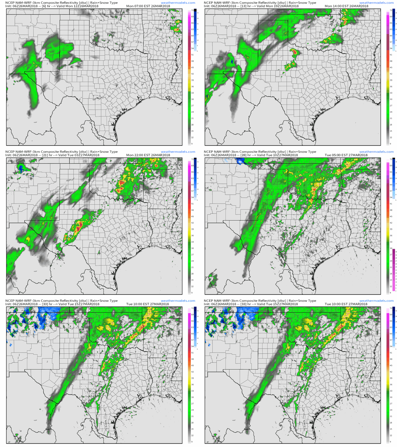
This simulated radar loop from the NAM model shows storms developing along that dryline this evening and moving NNE into the overnight hours. As the night progresses, notice how storms evolve from discrete cells into larger clusters. This will coincide with a transition in threats from large hail/tornadoes towards damaging winds and flooding rains. Lightning is of course a threat with any thunderstorm, severe or not. The best heavy rain dynamics will develop farther northeast into MO, but it only takes one cell to linger over a given area to produce localized flooding even where that’s not the greatest threat today. GIF via weathermodels.com.
Rain won’t stop tonight, as the dryline evolves into a cold front, it will sag southeastward tomorrow and Wednesday with additional rounds of severe storms and torrential rains. This map shows the NWS’s total precipitation forecast through Wednesday evening, and as you can see some places are expecting some fairly hefty totals. Note that this forecast is much broader/smoother than what the actual precipitation distribution will look like. While this map may show an entire county getting 3″, it’s more likely that one half of the county gets 5″ in training heavy thunderstorms, while the other gets 1″ from much lighter showers. I’ll cover tomorrow/Wednesday’s severe weather threats either this evening or tomorrow morning. Map via weathermodels.com.
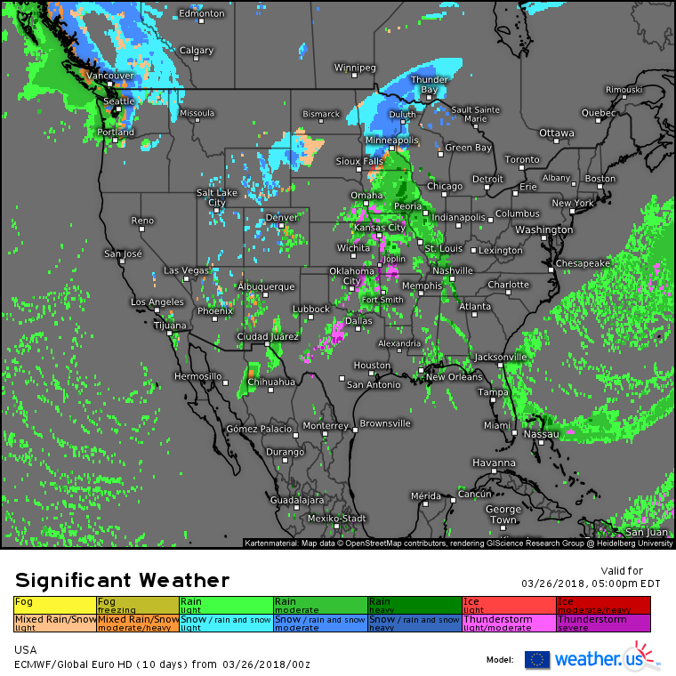
Elsewhere around the country today, the ECMWF’s overview map shows more quiet weather than not outside of the areas discussed above. The one exception to this will be Washington state where rain and mountain snow will develop on the southern fringe of a storm system moving into Canada.
For more details on the weather in your town, check out our new Weather Overview page: https://weather.us/weather/5809844-seattle (to get your town’s forecast, just type it into the search box near the top left). It displays all the most useful weather information for your town in an easy to use interface. For a tutorial on the Weather Overview page: https://blog.weather.us/weather-overview-interface/
For more details on the weather in ME/NH: https://forecasterjack.com/2018/03/26/cool-and-quiet-today-6/
-Jack
