Developing Storm To Bring Snow, Mixed Precip, And Storms To The Center Of The Country Tomorrow
Hello everyone!
Our very active weather pattern is rolling right along tonight as yet another storm system develops over the Plains. This one will focus its active weather in the central third of the country tomorrow, before moving east towards the middle of the upcoming week. As this system develops, look for quiet weather to briefly return to the coasts as New England’s powerful Nor’easter continues to drift slowly south and east away from the area, and the pipeline of Pacific moisture and upper level energy temporarily dries up out west.
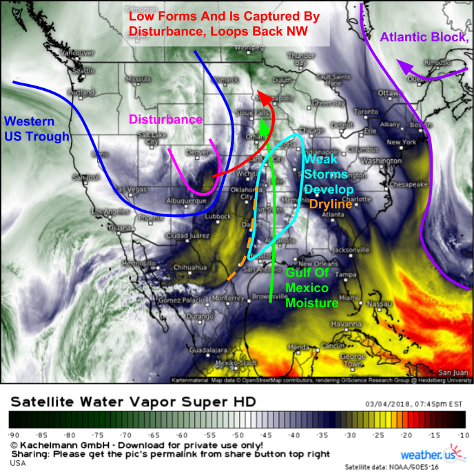
Here’s a look at GOES-East WV satellite imagery (what’s that?) this evening. There are several noteworthy elements on display here, each with their own impact on the developing storm. We have a large trough over the Rockies, and a disturbance pinwheeling out around the front side of it. That disturbance is in the process of forming a surface low pressure system in Eastern Colorado that will track northeast tonight. As the upper level trough attempts to shift east, it will run into strong blocking over the Atlantic which will result in the disturbance capturing the surface low and pulling it northwest, with plenty of SE to NW flow over the Plains. This flow pattern between the trough and the block will result in a stream of moisture moving into a cold Canadian airmass over the Northern Plains. The result of this process will perhaps unsurprisingly be heavy snow.
Here’s a look at the ECMWF’s surface pressure and precipitation type forecast for tomorrow afternoon via weathermodels.com. Notice how the system is tilted from NW to SE as the upper level features encounter the strong blocking over the Atlantic. A strong pipeline of moisture from the Gulf of Mexico will be surging north towards the low and its associated cold air, which will set the stage for a heavy snow event across the Dakotas as well as Montana and Minnesota.
Here’s a look at the system’s evolution over the next couple days according to the high resolution NAM’s forecast via weathermodels.com. Notice how the areas of rain and snow ongoing tonight quickly become much more consolidated as the disturbance and associated surface low eject out of Colorado and onto the Plains by tomorrow morning. As the low loops back to the north west, it stalls due to the blocking allowing bands of heavy snow to persist over the same areas for longer periods of time. Eventually, additional upper level energy arrives from Western Canada which helps kick the system southeast and shuts off the heavy snow in the Dakotas.
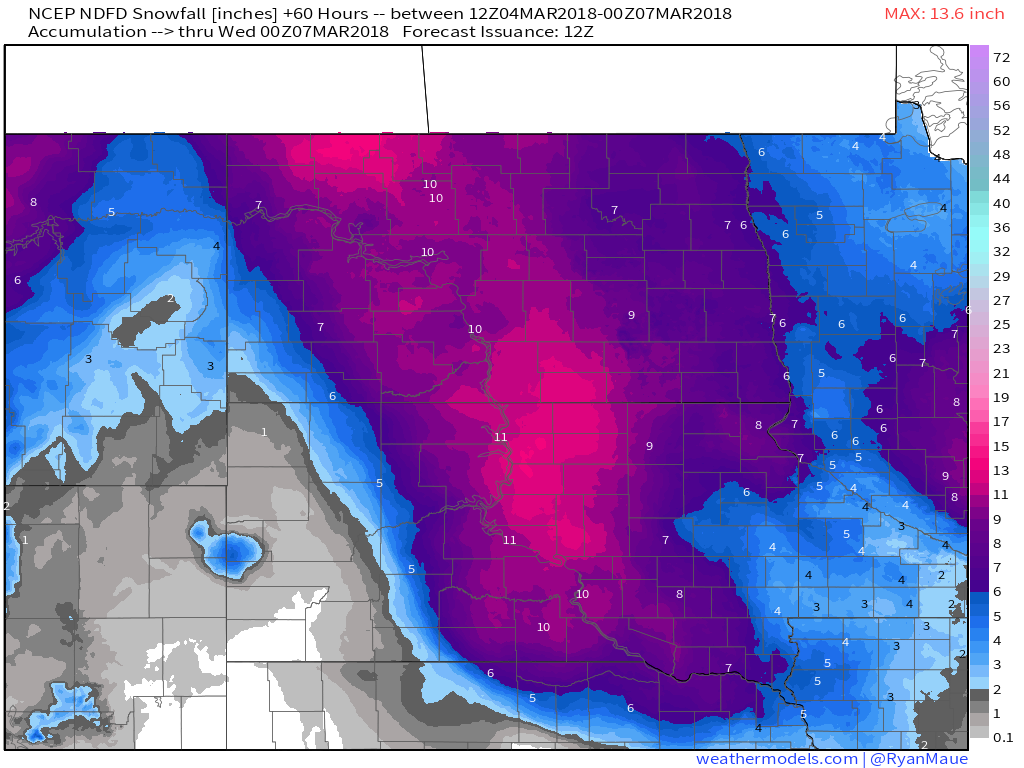
How much snow should you expect from this system? Here’s the National Weather Service’s forecast mapped via weathermodels.com. A general 6-12″ is expected for most of the Dakotas, with similarly high amounts across parts of Minnesota. Some places under the heaviest banding are likely to exceed the 12″ mark, with the most likely place for this being SD.
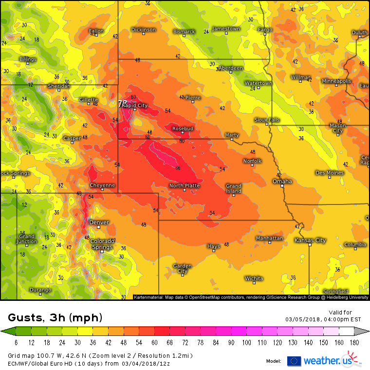
In addition to the heavy snow, high winds will also be a problem as this system gets going. ECMWF guidance shown above points to two areas of enhanced winds: one ahead of the storm in MN/WI/IA, and one just behind the storm in ND and NE. The winds behind the storm will be much stronger than those ahead of it, due to a phenomenon known as a “sting jet” which is an area of enhanced winds located just behind storms that wrap up enough to isolate a pocket of warm air, known as a “warm seclusion”. The sting jet will bring wind gusts over 60 mph to parts of SD and NE, and will blow the snow that falls in these areas into a frenzy, with blizzard conditions and near zero visibility occurring as a result. These winds will also be strong enough to cause scattered damage with power outages and property damage a distinct possibility.
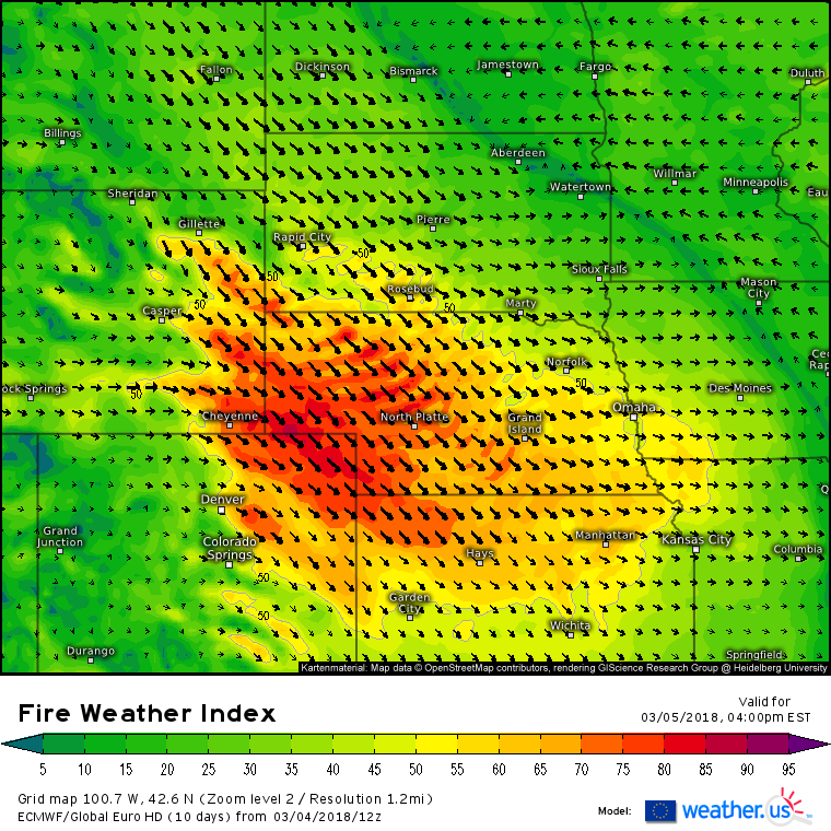
Farther south, away from the snow, the strong winds will pose a different threat: elevated fire danger. Strong winds and very dry air will combine to create conditions very conducive to rapid fire spread in parts of Nebraska and NE Colorado, as shown by the ECMWF’s Fire Weather Index forecast above. Be very careful in these areas, as any small spark could easily ignite a destructive wildfire at any moment.
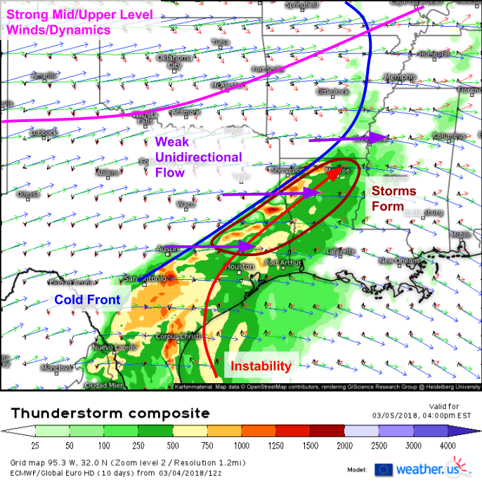
Farther south and east, a cold front will interact with Gulf moisture to produce a thunderstorm threat. The ECMWF’s thunderstorm composite (what’s that?) does a good job breaking down why storms will form, but why they will also not post a major severe weather threat. An axis of instability is noted across Eastern TX and NW LA, as shown by higher CAPE values between 500 and 1,000 J/kg. A cold front is noted both in the shifting winds at the surface (black vectors) and also as a sharp instability gradient. However, a close look at the wind vectors higher up in the atmosphere shows that all the strong mid/upper level winds and dynamics are located much farther to the north, closer to the center of the low itself. This means that winds in the mid/upper levels are fairly weak, and also fairly unidirectional, meaning that winds at the surface are blowing more or less in the same direction as winds aloft. This combination will result in a lack of organization in the storms we do see develop, and thus the severe weather threat, while certainly nonzero, remains relatively low.
This entire system will shift slowly east Tuesday before forming another powerful storm off the Northeast Coast by Wednesday evening. More details on that phase of the system to come.
-Jack
