Developing Storm To Bring Severe Storms To Parts of the Plains and Mississippi Valley
Hello everyone!
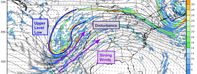
A storm system will slowly develop in the lee of the Rockies over the next few days as an upper level trough moves through the Desert Southwest. Warm moist air will flow north from the Gulf of Mexico ahead of this system while dynamics on the leading edge of the trough will combine with the storm’s frontal features to provide lifting for thunderstorm initiation. Finally, strong southwesterly flow aloft ahead of that trough will produce enough wind shear to support severe weather where storms develop. This post will discuss where severe weather is likely today, tomorrow, and Saturday as the system slowly develops and moves east.
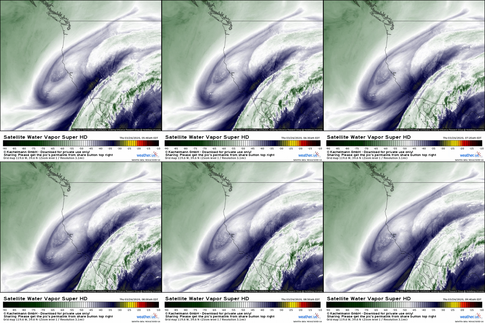
The upper level low we’ll be watching over the coming days is clearly visible just off the California coast near San Francisco. Ahead of that low, hints of rising motion are visible over the Desert Southwest just NW of a moisture plume moving northeast from the Subtropical Pacific. That moisture and lift will support the development of strong/severe storms once the system shifts a bit farther east.
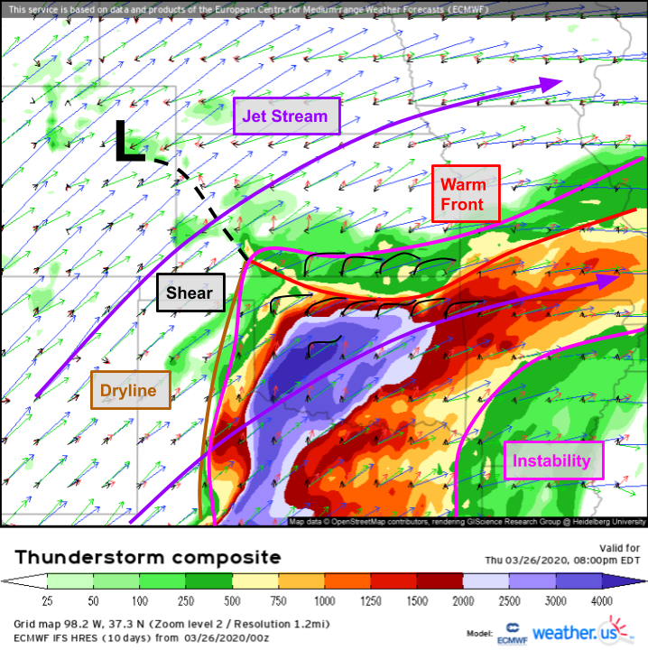
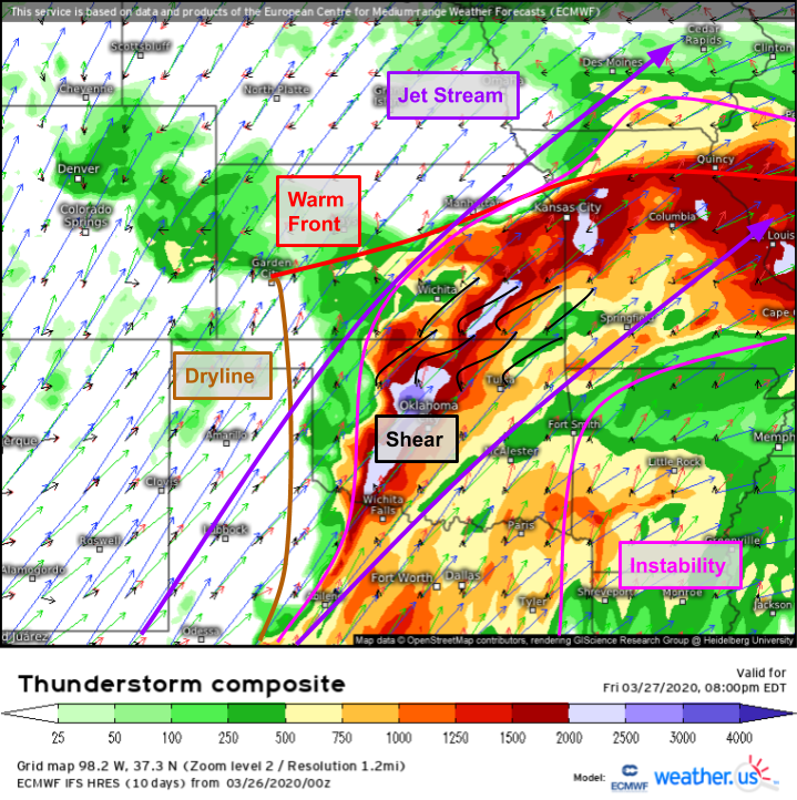
Thunderstorm Composite forecasts suggest that conditions will be favorable for severe thunderstorm development as soon as this afternoon. Ample instability will be present on the south side of a warm front and east of the dryline. Strong SW flow aloft will support strong shear, and the warm front/dryline will provide sources of rising motion for possible thunderstorm initiation. Just looking at this map, it’s easy to pick out Oklahoma as the area seemingly most at-risk for severe storms. There’s lots of instability, plenty of shear, and two sources of lifting. However, there’s a catch.
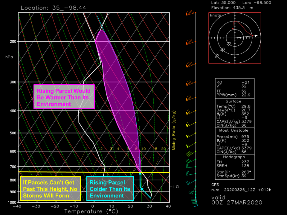
Here’s a forecast sounding for Central Oklahoma valid at 7 PM CDT today. The pink shading highlights the deep layer of the atmosphere where an air parcel forced to rise from the surface would be warmer than its surroundings. In other words, this is the layer where instability is present. However, to get to this layer, a rising air parcel would first need to rise through a ~6,000ft layer where the parcel would be colder than its surroundings. To overcome this resistance, a very strong source of lifting is needed. The dryline won’t quite do the trick and thus Oklahoma is expected to remain storm-free today. Farther north along the warm front, this layer of stable air is a bit shallower and cooler which means less upward motion is needed to produce storms. The warm front, a stronger source of lift than the dryline, should have no problem pushing parcels to the height required for them to rise freely to the tropopause.
That said, it will take a while for the cap to erode. Storms likely won’t develop until later tonight. Once they do, the strong southwesterly flow aloft will push them quickly NE into Kansas and Missouri. These areas are north of the warm front so a thin layer of cool air will be present near the surface. Thus tornadoes are not expected, and damaging winds are unlikely to be widespread. The primary threat will be large hail given very dry air in the mid-levels which will be supportive of evaporational cooling.
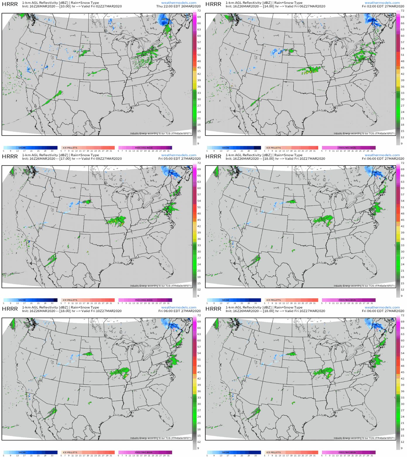
Here’s a short loop of the HRRR’s forecast for what radar imagery might look like late tonight/early tomorrow morning as storms develop in Kansas and move ENE into Missouri and Illinois.
The upper level low will shift east tomorrow which puts the Plains squarely under the best dynamics aloft. Strong divergent flow will be present in the mid/upper levels while efforts by the dryline/cold front/warm front to lift parcels to the level of free convection will be aided by large-scale lifting ahead of the approaching upper level low.
Thunderstorm Composite forecasts for tomorrow evening suggest that a much wider area will be at risk for severe thunderstorms. Southerly winds will push Gulf of Mexico moisture well north into Kansas and Missouri as the warm front lifts slowly north. The arrival of the upper level low over the Southern Rockies means that shear will continue to be more than supportive of severe storms. As with today, the trick will be to get storms forming in the first place. At the moment, that seems most likely in northeastern OK and southeastern KS. Because these storms will be developing in the warm sector, they won’t be sitting atop a layer of near-surface cold air. As a result, all severe hazards (tornadoes, large hail, and damaging winds) will be possible with these storms.
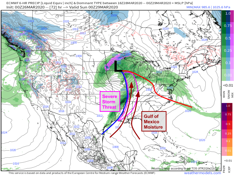
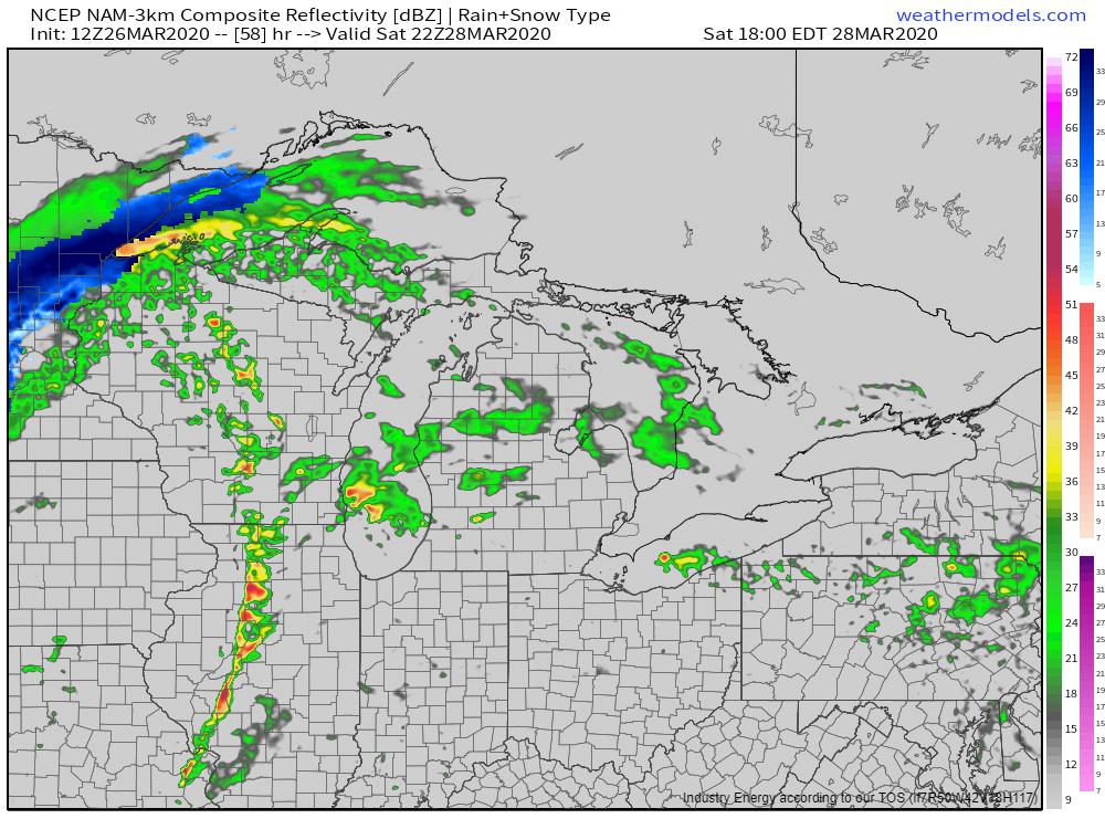
By Saturday, the storm will be in its mature stage over Iowa. Its cold front will be progressing quickly east through the Mississippi Valley where moisture from the Gulf of Mexico will continue to stream northward. Thus conditions will once again become favorable for severe storms to develop on Saturday afternoon. Given that a strong and fast-moving cold front will be the primary forcing mechanism for storms, a linear storm mode is most likely. This means that damaging winds will be the primary threat, though embedded tornadoes can’t be ruled out.
A snapshot of the NAM model’s simulated radar forecast shows a line of storms moving through Illinois on Saturday evening which is consistent with our expectations from above.
This system likely won’t be able to produce much if any severe thunderstorm activity on Sunday as it weakens over Ontario and brings a bout of cold rain/wintry mixed precip to the Northeast.
-Jack
