Developing Storm To Bring Heavy Snow And Severe Weather To Parts Of The Plains
Hello everyone!
After a few quiet days, our weather pattern is about to ramp back up as a storm system develops and intensifies in the lee of the Rockies tomorrow night before moving east on Monday. There are two sides to every storm, and because this one is developing in the center of the country, we’ll have to deal with impacts from both heavy snow and strong to severe thunderstorms.
Overview
Here’s a look at water vapor satellite imagery from this morning (what’s that?) showing several key elements of our storm beginning to organize. The most important feature is a strong disturbance located in Southern California. This energy is what’s going to trigger storm development east of the Rockies tomorrow evening. A strong stream of Pacific moisture is noted out ahead of the disturbance, and as this moisture encounters the Rocky Mountains, rain and high elevation snow is expected today from Northern Arizona through Utah to Wyoming. Downstream of this disturbance, a large ridge of high pressure is noted across the Southeast. This is important for a couple reasons. First, ridges favor warm weather, and this will be no exception. Warm, moisture laden air is already surging north from the Gulf of Mexico, a process that will continue through the next couple days. This will serve two purposes for our sensible weather discussion. First, it will add a strong supply of moisture to our storm, even as the Pacific moisture tap dries out, supporting heavy winter precipitation for a wide swath of the Northern Plains. Second, it will open up discussions of severe thunderstorms as a dryline sets up before the storm pushes a cold front into the warm, moist airmass.
Because it’s January and cold air is still the dominant force in storms like these, the winter weather aspect of the storm will be much more impactful than the severe weather, so that’s what I’ll discuss first. Snow will stretch from Arizona to Maine with this system, and some parts of the Plains could even see near-blizzard conditions as winds begin to pick up in bands of heavy snow.
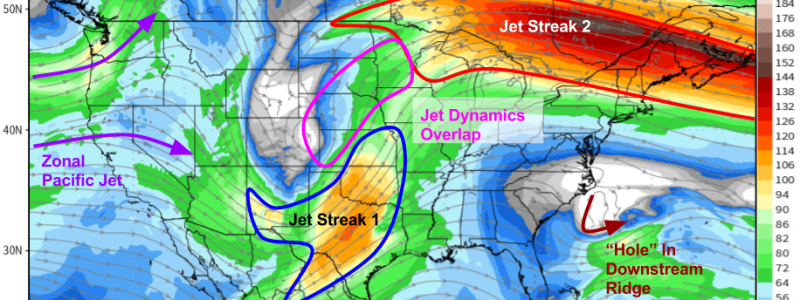
First, though, I’d like to look at the overall setup through the lens of the ECMWF 300mb wind forecast for tomorrow evening.
I’ve noted some of the important features on this map that will play a part in both the storm’s track, and its impacts. Two jet streaks, one located over Texas, and the other over Southern Canada, will play the biggest roles in shaping our storm. The first jet is curved cyclonically (counterclockwise) while the second is curved anticyclonically (clockwise). The left entrance region of the first jet and the right entrance region of the second jet are both known to be favorable for large scale rising motion, and when they overlap, the effect is accentuated. This will result in an area of rising motion from Western Kansas/Eastern Colorado up through Nebraska and into NW Iowa/southern Minnesota. This is the general area favored for heavy snow. I’ll dig into that in more detail below. The other features noted on the map give us important clues as to the storm’s track. There’s a ridge downstream of the storm, so it won’t move due east, but there are three elements that will work together to make sure the storm doesn’t just track NNE right into Central Canada. An upper level low is poking a hole in the aforementioned downstream ridge, which will weaken its steering influence. A zonally (W-E) oriented Pacific jet is noted moving into the West Coast, which means this storm will be a relatively quick mover, and will continue to move more east than north. Finally, an upper level low in Labrador is exerting a bit of a suppressive influence on the jet stream over Eastern North America, a process that will be important to New England’s forecast as it will help drive a cold wedge into the middle of the advancing warmth.
Map from weathermodels.com.
Now let’s dig into each impact in a little more detail.
Southwestern Snow
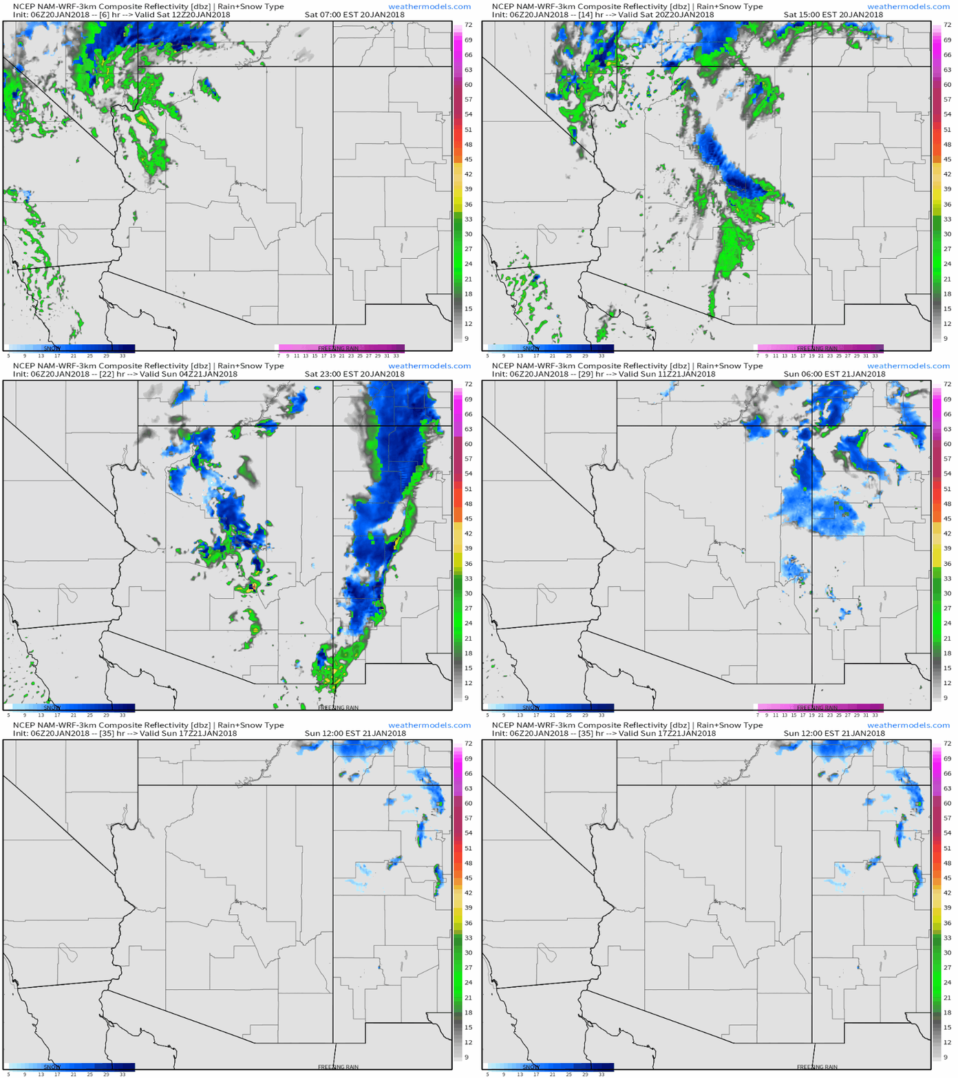
Here’s a simulated radar loop from weathermodels.com. that shows bands of moderate-heavy snow and lower elevation rain moving through Arizona today and tonight as the upper level disturbance discussed above moves east through the area. Snow from this system is already impacting parts of Utah and SE Nevada, as seen on our HD radar products (click to zoom to county level for an even closer look). Snow will continue in those areas as well, with moderate accumulations in the higher elevations.
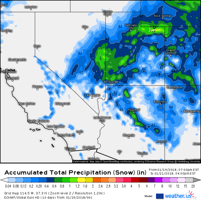
Here’s a look at how much QPF the ECMWF model expects to fall as snow through tomorrow afternoon (more on QPF, this map, and how to interpret/use it). With strong dynamics aloft ahead of the upper level disturbance, and cold air surging south, snow ratios will be a little higher than normal, especially at elevation. This means that areas seeing between .2 and .4″ of QPF (blue shading) will see 3-6″ of snow, areas seeing between .4 and .6″ of QPF (dark blue shading) will see 6-8″ of snow, and areas seeing .6-1.0″ of QPF (green shading) will see 8-12″ of snow. Snow ratios will be lower at lower elevations, so adjust those numbers down a little if you’re looking towards the valley floors where warmer temps will hang on the longest.
Great Plains Snow/Wind
After the disturbance exits the Southwest, it will emerge on to the Great Plains, where it will drive cyclogenesis (the process of storm formation) tomorrow afternoon.
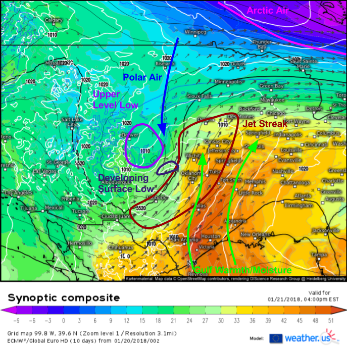
The ECMWF’s synoptic composite tool (what’s that and how do I use/interpret it?) is a great one for analyzing the dynamics behind cyclogenesis. We need two basic ingredients for cyclogenesis: a thermal gradient to provide a supply of baroclinic potential energy, and some sort of disturbance to act as a spark, igniting that potential energy and transforming it into kinetic energy in the form of wind. The synoptic composite map above shows that we have both of those criteria fulfilled. A warm and moisture laden airmass from the Gulf of Mexico will be moving north, running into a southward moving Polar airmass. The bitter cold Arctic air we’ve been dealing with in the past couple weeks will be bottled up well to the north in Canada, so this storm won’t be nearly as strong as some of those that have developed off the East Coast in the past few weeks where we’ve had an even sharper thermal gradient between tropical and Arctic airmasses. However, the tropical/polar gradient will be sufficient for a decently strong storm system to develop as the strong upper level disturbance we saw on WV satellite imagery above moves east and acts as the spark to ignite development.
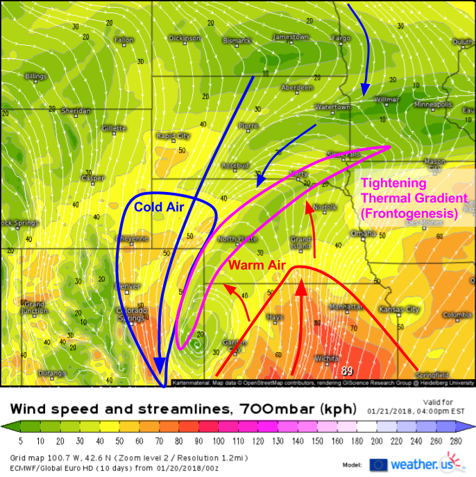
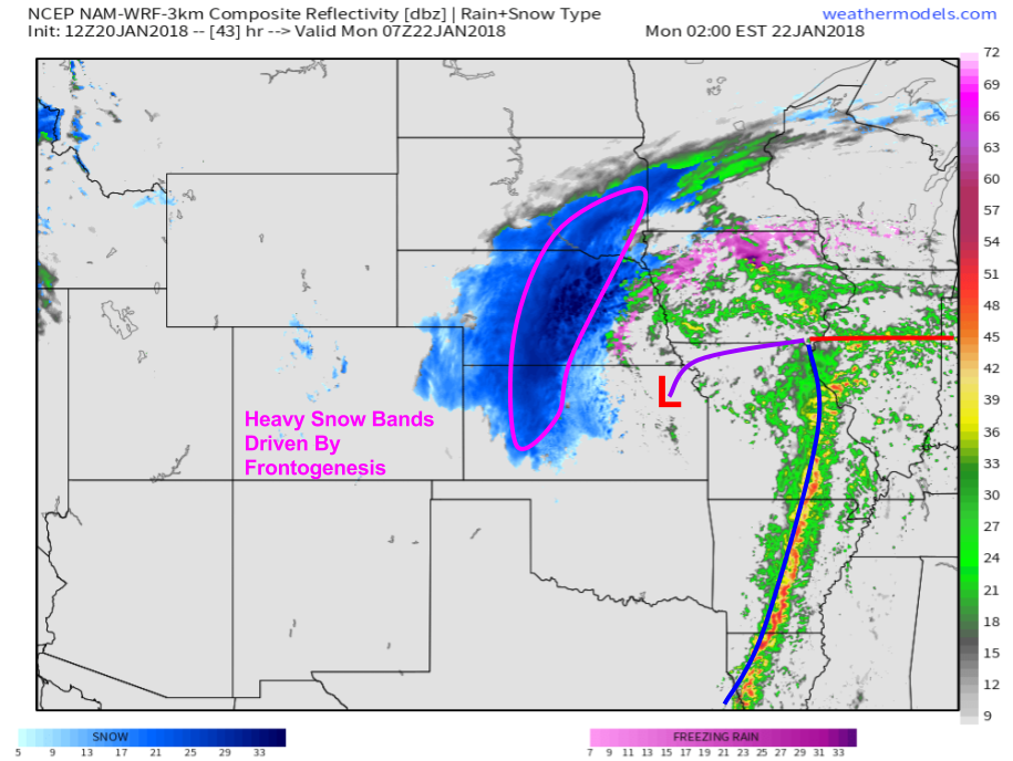
As cyclogenesis occurs, we’ll see a familiar set of events unfold in the mid levels of the atmosphere that will result in the development of heavy snow bands. The wind forecast for 10,000 feet tomorrow afternoon highlights this process, known as frontogenesis, that results in the creation of a front. This process is important for the development of heavy snow bands, because it results in converging airstreams in the low/mid levels. Not only does this contribute to rising air that leads to precipitation, it also strengthens the thermal gradient due to the warm airmass coming in closer proximity to the colder airmass. As each airstream intensifies due to potential energy being converted to kinetic energy (energy of motion, in this case wind), the frontogenesis dynamics and banding will also intensify.
This simulated radar map shows the result of the frontogenesis dynamics discussed above. Notice the band of heavy snow wrapping around the back side of the storm system as it moves east through the Plains early on Monday morning. The storm will be located in NE Kansas, but because the mid level frontogenesis dynamics are located to the NW of the storm system, that’s also where to expect the heavy snow bands. These dynamics will be strong, and snow growth should be strong, but the airmass will only be marginally cold enough for snow so as a result snow to liquid ratios should be right around the typical 10-12:1 range. Snow in the frontogenesis band will fall at rates of 1-3″ per hour, with visibilities dropping to near zero, especially once the wind picks up.
Map from weathermodels.com.
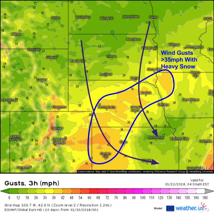
Speaking of wind, here’s the ECMWF’s wind gust forecast for Monday morning. Notice the widespread area of wind gusts above 35mph from NW Kansas through Central Nebraska and into NW Iowa. This is the same place we’re expecting the heavy snow due to the frontogenesis dynamics discussed above. The combination of heavy snow, and blowing snow due to the strong winds will result in blizzard conditions that will reduce visibility to near zero at times. Watch for blowing and drifting snow to continue to cause problems for travel even after the snow stops falling Monday afternoon, as strong winds will linger before tapering off overnight Monday into early Tuesday morning.
Here’s an idea of how much snow to expect in the Plains from this system. As the storm develops, the snow shield will contract and intensify, meaning that there will be a narrower band of heavier snow in places like SE MN and NW IA compared to NE, KS, and CO. There will be sharp cutoffs in this area both to the north where total QPF will be limited, and to the south where snow will begin as rain or mixed precipitation. These areas at the edge of the heavy snow zone are areas of higher than normal forecast uncertainty, as a track change as small as 30 miles would mean the difference between 2″ and 12″ of snow. There’s higher confidence to the southwest where even if the snow shield shifts around a little bit, the same general ideas still apply.
Severe Weather
While areas north and west of the storm’s track deal with heavy snow and blizzard conditions, areas south and east of the storm’s track will deal with the threat of strong to potentially severe thunderstorms as a dryline moves east and interacts with a warm and moisture rich Gulf of Mexico airmass.
The ECMWF’s thunderstorm composite shows a dryline setup in Texas tomorrow evening. A dryline is a boundary between dry and moist airmasses, and often acts as a focus for thunderstorm activity, similarly to a cold front. Remember for severe thunderstorms we need three ingredients: instability, a trigger, and shear. We have 2/3 criteria taken care of with this setup, where the severe threat is conditional upon the sufficient presence of the third. The dryline will provide the trigger and an intense jet streak located over the region (discussed above) will provide the shear. The only thing we may be missing is the instability. The ECMWF forecast shown above indicates a narrow corridor of >500 J/kg of CAPE from the Austin area up towards far SE OK and far SW AR. 500 J/kg is enough to get thunderstorms to develop, but is near the low end of what’s considered supportive of severe weather. However, despite the marginal instability, there’s so much wind energy aloft that even weak thunderstorms may be able to mix down wind gusts capable of low end wind damage.
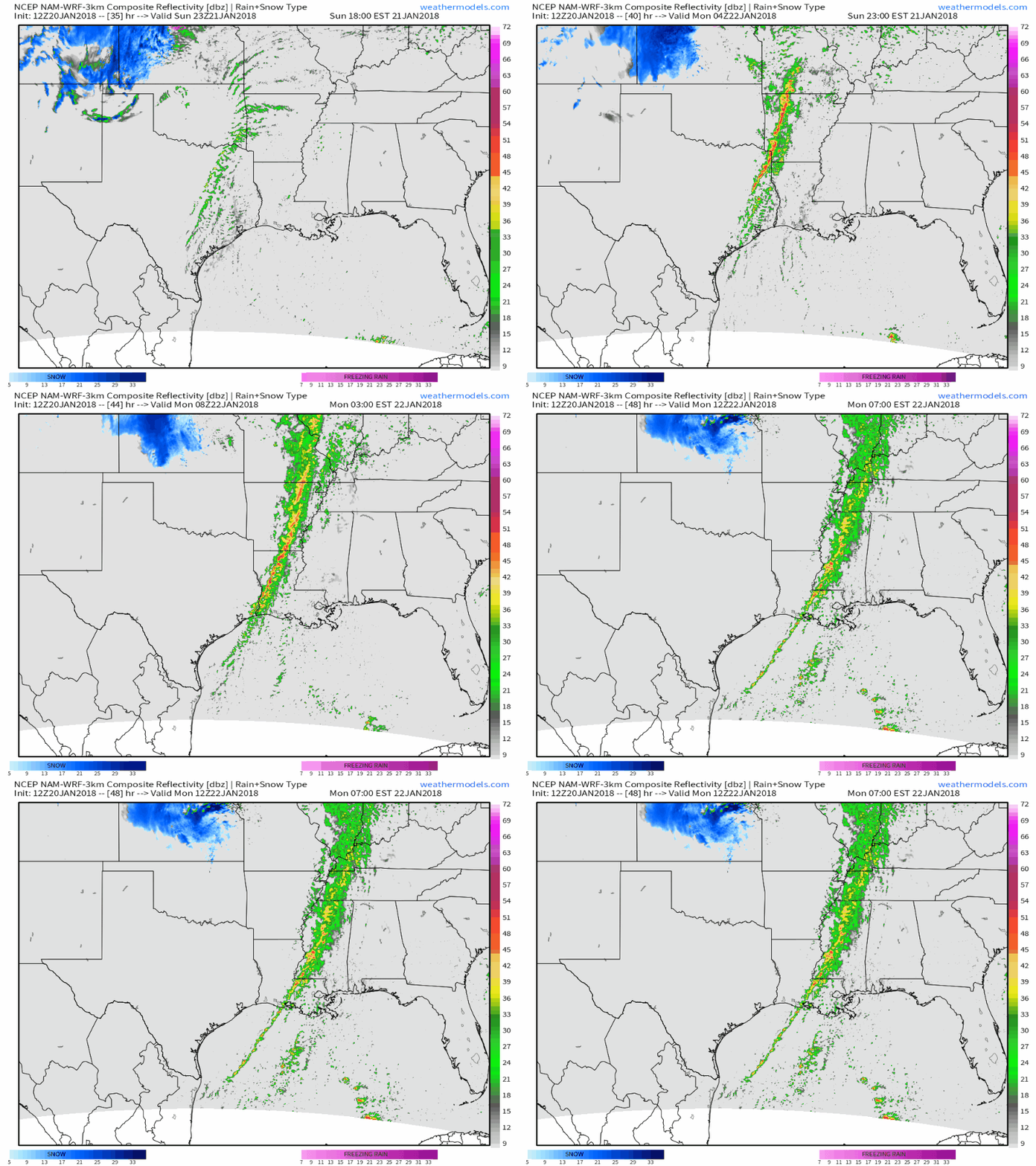
Here’s a short animation of what one model expects the radar to look like overnight Sunday into Monday. The strong forcing that develops as the dryline transitions to a cold front will promote the development of a line of storms that could extend as far north as South-Central Missouri. Damaging winds will be the greatest threat, though a weak tornado or two can’t be ruled out. Storms will weaken as they move east on Monday, though another weaker severe threat is possible in the New Orleans area. More on that tomorrow evening/Monday morning.
Map from weathermodels.com.
Northeast Impacts
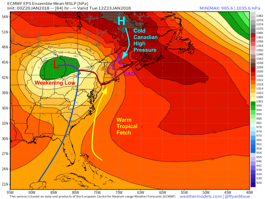
Eventually this storm will reach the Northeast, as nearly all storms that impact the US do. While the track west of the region means the area will be on the warm side of the storm, an intrusion of cold air will sneak in just before the storm arrives, and is likely to cause problems for parts of Northern New England on Tuesday. The phenomenon responsible, known as cold air damming (CAD) occurs when a spindle of high pressure settles in on the east side of a mountain range, such as the Appalachians. Warm air moving in from the southeast, perpendicular to the mountains, will rise up and over the cold air which is too dense to be pushed up the mountains. As a result, the cold air is not displaced, even as warm air is transported into the region. What we end up with is low level cold air that stubbornly remains locked into place as warm air surges in aloft, a recipe for mixed precipitation.
Map from weathermodels.com.
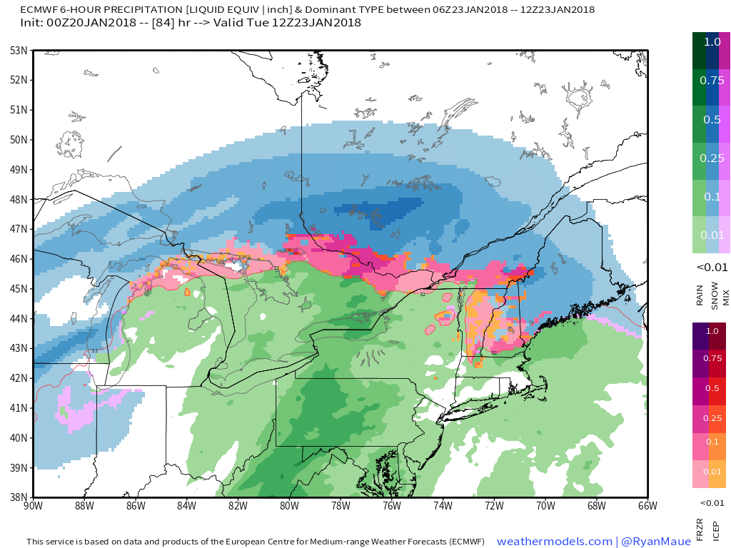
It’s not a surprise then that the ECMWF’s precipitation type forecast for Tuesday morning looks like this. While New York and Southern New England see rain in the warm sector, the cold air is locked into place across Maine, New Hampshire, and Eastern Vermont. Areas farther NE will see cold air deep enough for snow, but that will quickly transition to sleet and freezing rain as warmer air works in aloft. Depending on the exact timing of each changeover, from snow to sleet, then from sleet to ice, then from ice to rain (if that even happens at all) will determine how much snow and ice falls, but at the moment the storm looks to remain more of a nuisance event as opposed to anything capable of serious ice damage. Models are notorious for overestimating temperatures during CAD events, so if you’re in VT, NH, or ME (with the exception of the ME coast NE of Brunswick) take any forecasts of plain rain with a large grain of salt!
Map from weathermodels.com.
I’ll have more details on this part of the storm as we get closer!
Track the storm’s evolution not only with our model data at weather.us and weathermodels.com, but also with our HD radar products and Super HD satellite imagery (more information on how to access/interpret our satellite products) from the brand new GOES-East (formerly GOES-16) satellite. You can click any map to zoom in either to state or even county level for more details! Also be sure to watch current observations to see various aspects of the storm develop. Use this data to keep track of wind gusts in the Northern Plains, moisture return across Texas, and the progress of cold air moving into New England as the storm evolves into the early part of the coming week. To see the latest data, press the refresh button at the top left of each map.
Next blog update will be either tomorrow evening or Monday morning.
-Jack


