Developing Storm To Bring A Stripe Of Snow To The Midwest And Severe Storms In Parts Of The Plains Over The Next Few Days
Hello everyone!
After several days stormy weather on both coasts, the focus today will shift towards the center of the country as the Nor’easter from earlier in the week is now well offshore, and drier air is now pushing onshore in the West. Just because much of California will see the sun today doesn’t mean that the Atmospheric River’s influence is over, but rather that it has shifted farther east. A pipeline of moisture and upper level energy is now pointed at the Northwestern Plains from Colorado up into the Dakotas. This combination of moisture and upper level energy will result in the formation of a storm system in Eastern Colorado this morning, which will move into Kansas this afternoon/evening. Snow is expected north of the low, with severe storms possible to its south and east.
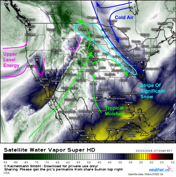
Here’s a look at this morning’s GOES-East water vapor satellite imagery (what’s that?), which shows a number of elements lining up for significant snow from the Dakotas southeastward towards the mountains of the Mid Atlantic. A boundary is noted between warm moist air from the Pacific (at the nose of the atmospheric river) and cold dry air from the Polar regions. This boundary, like all boundaries, is three dimensional, and, like most frontal boundaries, slopes poleward with height. In the WV image above, we’re looking near the top of the atmosphere, which means that we’ll see the boundary near its northernmost extent. Lower down in the atmosphere, the boundary will be farther south. As air parcels are pushed towards the boundary from the south, they will rise as they travel up the frontal surface to the north. This means that anywhere between the surface boundary and the upper level boundary, you’re going to have moisture laden air parcels from the south rising through the atmosphere, a perfect recipe for precipitation. As you move closer to the upper level boundary, you’ll have a deep enough cold airmass to support snow.
The ECMWF’s forecast for tomorrow morning does a good job highlighting what to expect as a result of the front and its dynamics discussed above. The surface boundary is seen as the region where isobars “kink” and change orientation from SW-NE to SE-NW (black annotation line). The upper level boundary is seen as the northeasternmost extent of the precipitation shield, northward of which the Gulf moisture supply runs out. As air parcels are forced to rise through this frontal zone, which slopes upward as you move to the north, precipitation will result, and given the strength of the front, and the depth of the available moisture, this precipitation will be heavy at times. Close to the surface boundary, the cold air will not be deep enough to support snow, and a cold rain is expected. As you head north though, the cold air gradually gets colder and deeper, with a change to snow eventually occurring in Northern parts of Iowa, Illinois, and Indiana. The dynamics associated with rising motion and melting snowflakes just south of the rain/snow line will promote some dynamic cooling, but as the sun comes up tomorrow morning, this may be offset some by the strong rays of the late March sun. Map via weathermodels.com.
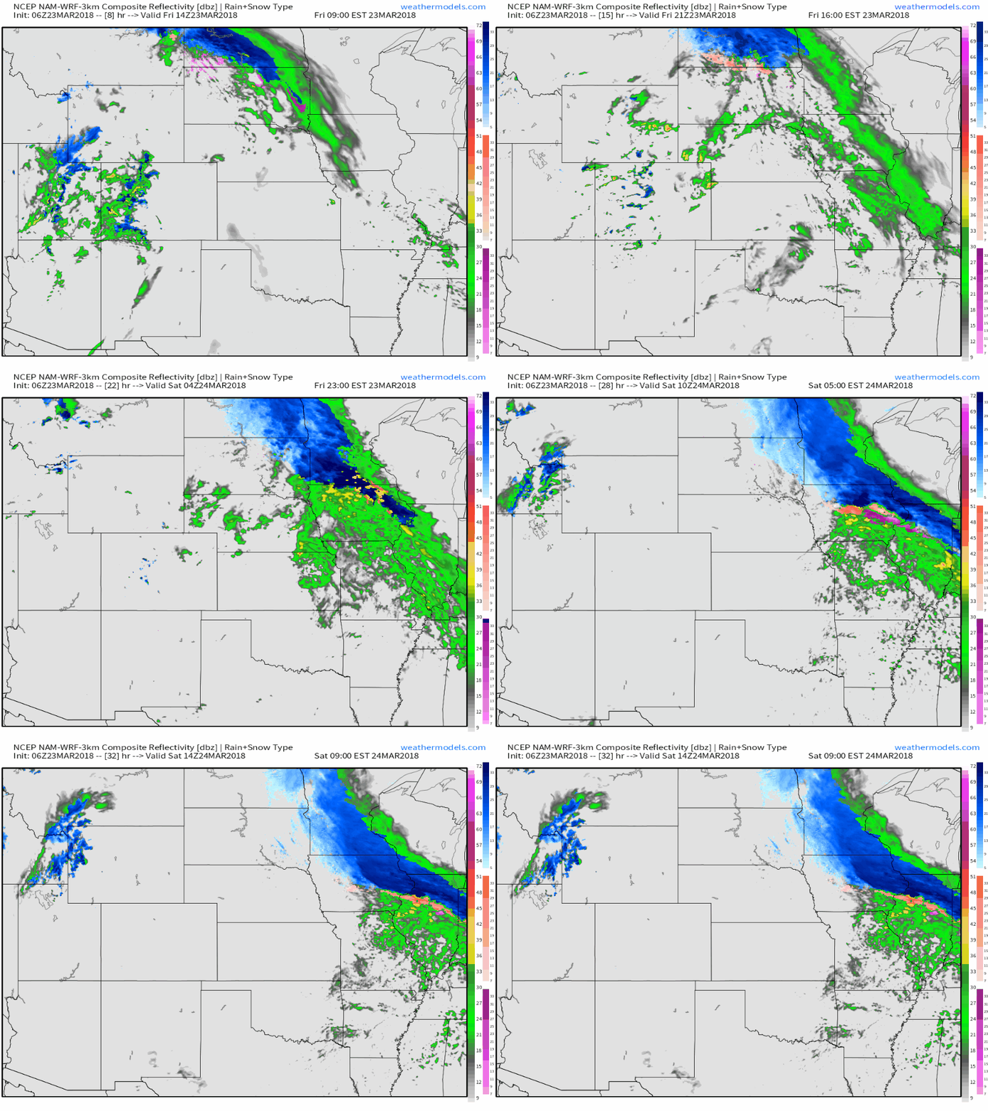
Here’s the NAM model’s simulated radar forecast for today and tonight, showing rain and snow breaking out in the frontal zone extending from North Dakota southeastward through MN, IA, IL, and into IN/OH/KY. You can see that some of the bands forecast to develop will likely be quite heavy, with snowfall rates over 1″/hr possible. Some areas of mixed precipitation may exist near the rain/snow transition as the warm and cold airmasses battle it out. Snow will travel farther southeast tomorrow, reaching the mountains of the Mid Atlantic states by tomorrow evening. GIF via weathermodels.com.
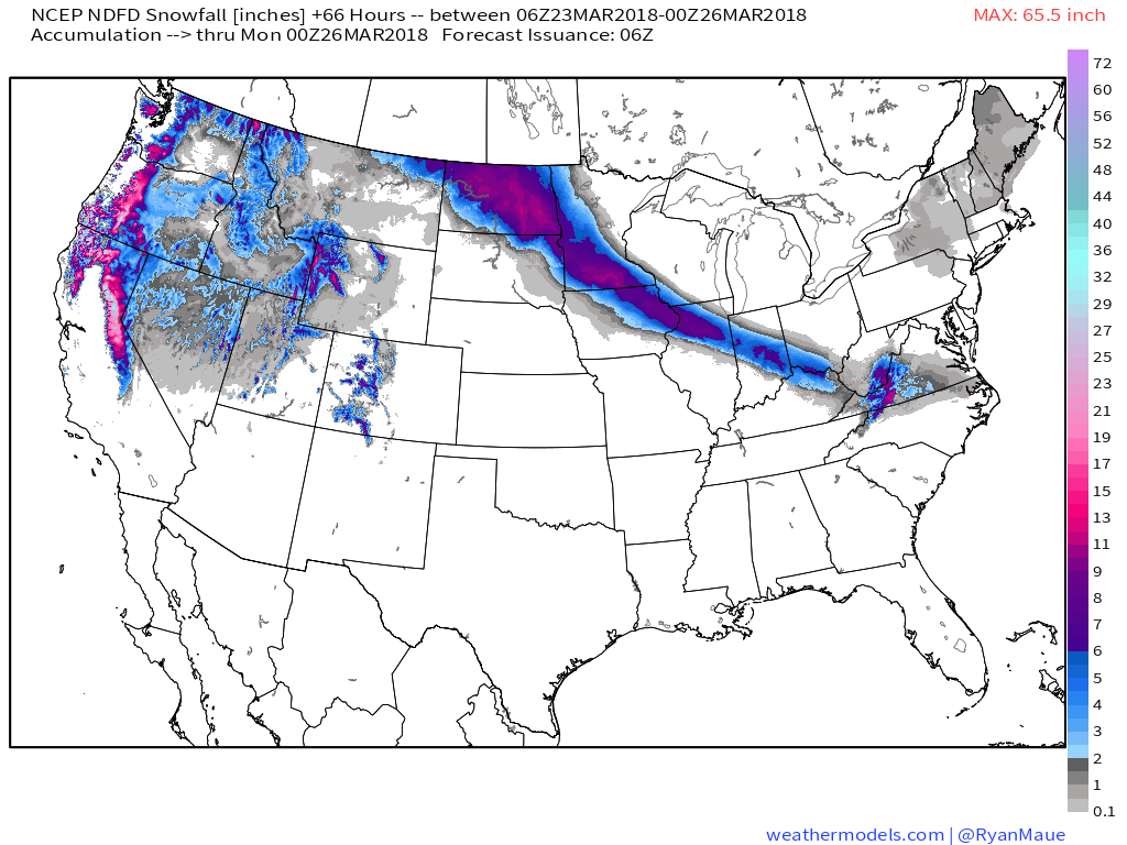
Here’s the NWS’s forecast for how much snow to expect over the next couple days. You can clearly see the stripe of 4-8″ accumulations forecast from this system, with locally higher amounts possible in ND as well as the mountains of VA, NC, and WV, where terrain dynamics will add another layer of forcing to help enhance precipitation. Elsewhere across the country, the continued presence of a trough in the West will result in additional mountain snow accumulations, while a weak upper level disturbance will bring flurries to parts of New England tomorrow night. Map via weathermodels.com.
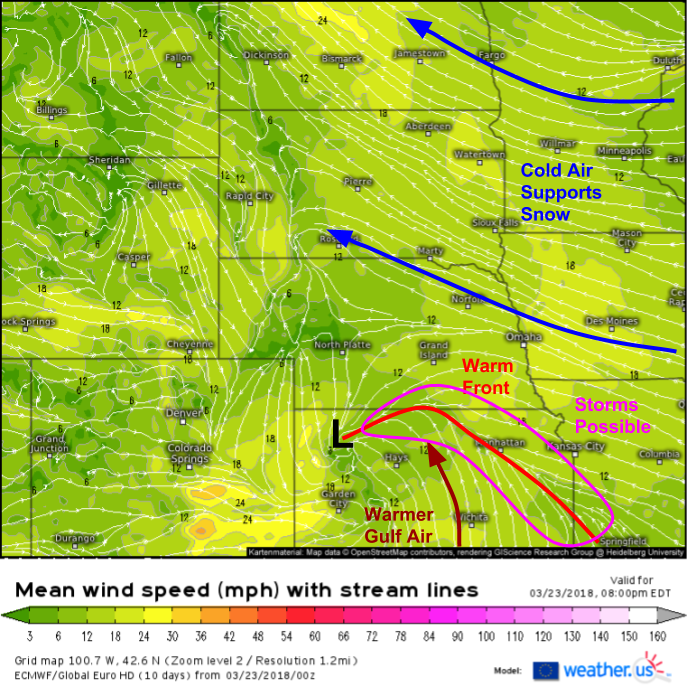
In addition to the snow threat north of the developing surface low, and associated frontal boundary, we also have a severe weather threat from this system today along the surface front itself. ECMWF 1om wind forecasts show warm air flowing north from the Gulf of Mexico through the Southern Plains today, and once it reaches the warm front in Kansas, it will reside under mid level temps sufficiently cool enough for some instability to develop. However, satellite imagery shows abundant cloud cover in this area currently, which will severely limit how much the sun can heat and destabilize the lower levels. While instability will be modest at best, there is a decent amount of shear available, so any storms that do pop up along the warm front (forcing mechanism) will be capable of some hail and damaging winds.
For more information on your local forecast: https://weather.us/. Be sure to check out our new Weather Overview feature, which lets you quickly and easily look at all the weather information you need to plan your day, or your week.
For more information on the local forecast for ME/NH: https://forecasterjack.com/2018/03/23/another-typically-cool-early-spring-day-today/
-Jack


