Developing East Coast Storm To Bring Chilly, Breezy Rain This Weekend
Hello everyone!
A storm system is moving east through the Southern Plains this morning, and it will organize into a stronger system by the time it reaches the East Coast this weekend. No need to get too worried though, an intricate set of atmospheric interactions will prevent this from being a powerhouse nor’easter. Curious to learn how those interactions are working together this week? My blog post from Tuesday, which is all still relevant today, is the place to go. This post will be shorter and more impacts-focused.
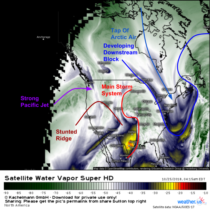
In case you didn’t catch Tuesday’s blog, here’s a quick overview of some of the main features involved in influencing the evolution of our storm courtesy of GOES-East’s WV satellite imagery. The storm itself is currently centered in the mid levels near Kansas City. Ahead of the storm, we have a decent shot of cold air moving into New England. If this was December, we’d be all set for a major winter storm. But alas, it’s October, so even a decent shot of cold air isn’t going to be enough for widespread snow. One other quick note is the departing storm in the Canadian Maritimes, which will help “block” up the flow downstream, allowing the next storm to turn up the coast as opposed to slide out to sea. To the west, a strong Pacific jet has cut down the West Coast ridge, which now exists in dramatically reduced fashion over the Southwest.
Here’s a look at this morning’s national radar composite, which shows rain extending from Canada to the Gulf of Mexico due to our storm system. With no cold air to speak of, fairly weak dynamics aloft, and little in the way of instability, rain will be just about the only impact for the center of the country as this storm moves east today. It won’t be until the storm arrives off the East Coast this weekend that we’ll start to look for somewhat more impactful weather.
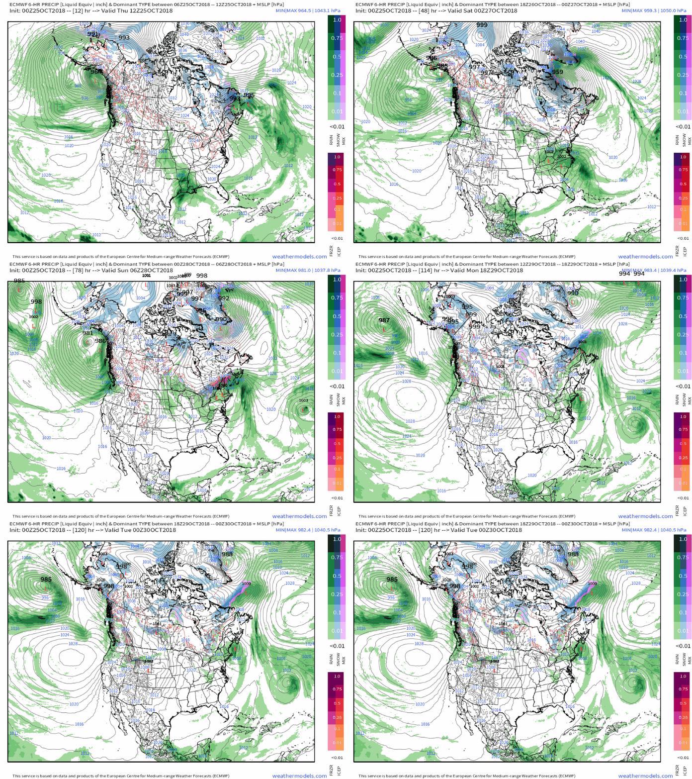
Here’s a quick overview of the evolution of the system through the next few days. Note the rain in the Southeast today becomes a bit heavier as the storm turns up the East Coast. As the storm’s moisture encounters the cold air over New England, rain changes to snow and potentially some mixed precip, but because it’s still October, that’s limited to the higher terrain. Finally, note the second storm trying to develop off the East Coast in the wake of the first. While it likely won’t be all that significant, it’s worth keeping half an eye on. The upper level energy associated with that system is much more compact/well defined. GIF via weathermodels.com.
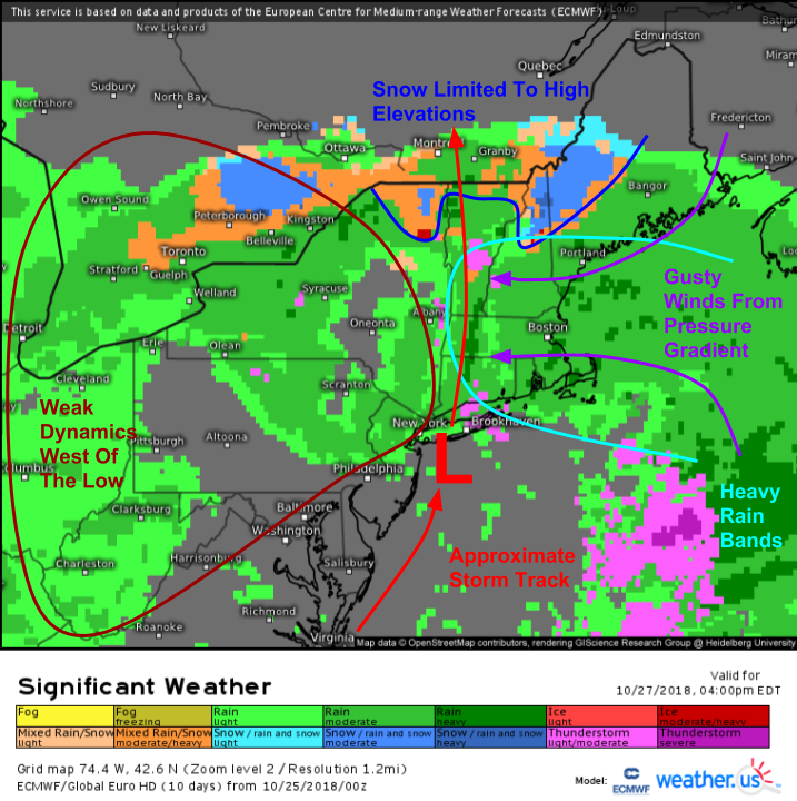
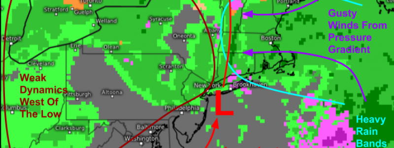
Here’s a look at the ECMWF’s significant weather overview map for Saturday afternoon. The results of all the dynamics discussed both above, and especially in Tuesday’s post, are apparent. Snow will fall due to that cold air injection, but because it’s still October, and the low is tracking near New York City, the frozen precip will be limited to those higher elevations. West of the low, there won’t be much in the way of dynamics because the system’s energy is fairly weak, and spread out over a large area. We won’t have any “wraparound bands” or deformation zone dynamics. Some steadier rain will wrap around into Upstate New York, but otherwise showery precip will be the name of the game as winds shift around from north to west. Meanwhile in Southeastern New England, there will be some heavy rain bands and gusty winds ahead of the low, but the low’s weak overall strength will cap the magnitude of both impacts.
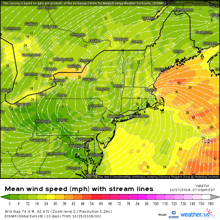
Here’s a closer look at the wind forecast from the ECMWF model for Saturday night. Note that the strongest winds will be limited to the New England coastline, but that in that area, they will be fairly strong. Sustained winds of 30-40 mph from Cape Cod up into Maine is enough to cause some scattered/localized power outage issues, especially when combined with the heavy rain. Farther west though, there’s very little if any wind on the back side of the low. The frontside winds are all pressure-gradient driven as the low pushes strong Canadian high pressure out of the way.
The onshore winds will cause some coastal flooding problems, especially around Saturday afternoon’s astronomically high tide. Typically susceptible areas will see some minor splashover/inundation, but the weak and fast-moving nature of the storm will preclude any significant impacts. Rough surf will also be a concern in terms of beach erosion, but again no overly significant impacts are expected.
Follow the weather.us team on twitter for more updates on this storm in the coming days. We’re @WeatherdotUS, @RyanMaue, and @JackSillin.
-Jack
